 | Polhov Gradec - Tošč (via Grmada)
Tošč, which became the highest peak of the Polhov Gradec Hills decades ago when the Yugoslav army lowered Pasja ravan by 9 metres, is located nor...
2 h 30 min |
 | Polhov Gradec - Tošč (via Mačkov graben)
Tošč, which became the highest peak of the Polhov Gradec Hills decades ago when the Yugoslav army lowered Pasja ravan by 9 metres, is located nor...
1 h 50 min |
 | Gabrje - Tošč
Tošč, which became the highest peak of the Polhov Gradec Hills decades ago when the Yugoslav army lowered Pasja ravan by 9 metres, is located nor...
3 h 5 min |
 | Petačev graben - Tošč (via Sveta Jedert)
Tošč, which became the highest peak of the Polhov Gradec Hills decades ago when the Yugoslav army lowered Pasja ravan by 9 metres, is located nor...
1 h 50 min |
 | Škofja Loka (Vincarje) - Lubnik (ridge path)
Lubnik is a 1025 m high mountain that rises steeply west of Škofja Loka. From the summit, where a mountain hut stands, there is a beautiful view ...
2 h 15 min |
 | Škofja Loka - Lubnik (via Stari grad)
Lubnik is a 1025 m high mountain that rises steeply west of Škofja Loka. From the summit, where a mountain hut stands, there is a beautiful view ...
2 h 15 min |
| Škofja Loka - Lubnik (via Luža)
Lubnik is a 1025 m high mountain that rises steeply west of Škofja Loka. From the summit, where a mountain hut stands, there is a beautiful view ...
2 h |
 | Praprotno - Lubnik
Lubnik is a 1025 m high mountain that rises steeply west of Škofja Loka. From the summit, where a mountain hut stands, there is a beautiful view ...
2 h 15 min |
 | Preserje - Krim
Krim is a 1,107-metre-high mountain rising south of the Ljubljana Marsh. From the summit, where a mountain hut and several transmitters stand, th...
2 h 20 min |
 | Dom v Iškem Vintgarju - Krim
Krim is a 1,107-metre-high mountain rising south of the Ljubljana Marsh. From the summit, where a mountain hut and several transmitters stand, th...
2 h 15 min |
 | Dolenja Brezovica - Krim
Krim is a 1,107-metre-high mountain rising south of the Ljubljana Marsh. From the summit, where a mountain hut and several transmitters stand, th...
2 h 10 min |
 | Iška - Krim
Krim is a 1,107-metre-high mountain rising south of the Ljubljana Marsh. From the summit, where a mountain hut and several transmitters stand, th...
2 h 10 min |
 | Sopota - Kum (Nežina pot)
Kum, at 1,220 metres, is the highest peak in the Posavje Hills. As it rises above the Zasavje region, some call it the Zasavje Triglav. At the su...
2 h |
 | Spodnja Kokra - Javorov vrh
Javorov Vrh (recorded in some sources as Javorjev Vrh) is a 1,434 m high mountain northeast of Preddvor. The summit, with its registration box an...
2 h 20 min |
 | Potoče - Javorov vrh (via Potoška gora)
Javorov Vrh (recorded in some sources as Javorjev Vrh) is a 1,434 m high mountain northeast of Preddvor. The summit, with its registration box an...
2 h 45 min |
| Potoče - Javorov vrh (direct way)
Javorov Vrh (recorded in some sources as Javorjev Vrh) is a 1,434 m high mountain northeast of Preddvor. The summit, with its registration box an...
2 h 30 min |
 | Mače - Javorov vrh (Mačenska pot)
Javorov Vrh (recorded in some sources as Javorjev Vrh) is a 1,434 m high mountain northeast of Preddvor. The summit, with its registration box an...
2 h 55 min |
| Mače - Javorov vrh (via Kozjek)
Javorov Vrh (recorded in some sources as Javorjev Vrh) is a 1,434 m high mountain northeast of Preddvor. The summit, with its registration box an...
3 h 10 min |
 | Gornji Grad - Lepenatka (via Kal)
Lepenatka is a grassy peak located south of the 1557-metre-high Rogatec. From the summit, which has a summit register box and stamp, there is a b...
3 h |
 | Gornji Grad - Lepenatka (on ridge)
Lepenatka is a grassy peak located south of the 1557-metre-high Rogatec. From the summit, which has a summit register box and stamp, there is a b...
3 h |
 | Podbrdo - Kobla
The summit is located in the Lower Bohinj Mountains between Črna prst and Soriška planina. Directly below it is a railway tunnel connecting Bohin...
3 h |
 | Zali Log - Koprivnik
Koprivnik is a 1393-meter-high mountain located between Blegoš and Mladi vrh. From the summit, which has a registration box and a stamp, the view...
2 h 45 min |
 | Golice - Vivodnik
Vivodnik, at 1508 meters, is the highest peak of Menina planina, a plateau rising south of Gornji Grad. From the summit, which has a small observ...
2 h 45 min |
 | Razdrto - Vojkova koča na Nanosu (gentle path)
The Vojkova koča mountain hut is located on the southern edge of the Nanos plateau, directly next to Pleša, a peak clearly visible from the highw...
2 h 20 min |
 | Vrčice - Mirna gora (via Škrilj)
Mirna gora is a 1047 m high, forested peak located on the southeastern edge of Kočevski rog. From the summit, which has a summit register and sta...
2 h 10 min |
| Vrčice - Mirna gora (via Planina)
Mirna gora is a 1047 m high, forested peak located on the southeastern edge of Kočevski rog. From the summit, which has a summit register and sta...
2 h 10 min |
 | Hotovlja - Pasja ravan
Pasja ravan is the second-highest peak in the Polhograjsko hribovje. A few decades ago, at 1029 meters, it was the highest, but in the second hal...
1 h 45 min |
| Ernejčkov graben - Pasja ravan
Pasja ravan is the second-highest peak in the Polhograjsko hribovje. A few decades ago, at 1029 meters, it was the highest, but in the second hal...
3 h 15 min |
 | Potoče - Potoška gora
This forested peak is situated above Preddvor, between Javorov vrh and the Iskra na Jakobu mountain hut. The summit has a bench and a registratio...
2 h |
 | Spodnja Kokra - Potoška gora
This forested peak is situated above Preddvor, between Javorov vrh and the Iskra na Jakobu mountain hut. The summit has a bench and a registratio...
2 h 5 min |
 | Vrtovin - Kucelj (on Čaven)
Kucelj is located on the southern slopes of the Trnovski Forest, northwest of the Vipava Valley. From the bare summit, where a cross stands, ther...
2 h 15 min |
 | Vrtovin - Kucelj (on Čaven) (via Koča na Mali gori)
Kucelj is located on the southern slopes of the Trnovski Forest, northwest of the Vipava Valley. From the bare summit, where a cross stands, ther...
3 h |
 | Vrtovin - Veliki Modrasovec
Veliki Modrasovec is located on the southern part of the Trnovski Forest near Predmeja. On the summit stands an old military building, which we m...
3 h 10 min |
 | Selski most - Babji zob (via Kupljenik)
Babji zob is a viewpoint above the village of Kupljenik near Bled. The precipitous peak, which has a registration box, offers a beautiful view of...
2 h 40 min |
 | Matavun - Vremščica
Vremščica is a mountain range stretching between Senožeče, Pivka and Divača. Its highest peak is Velika Vremščica. The view from the summit exten...
3 h 15 min |
| Podgora - Vremščica
Vremščica is a mountain range stretching between Senožeče, Pivka and Divača. Its highest peak is Velika Vremščica. The view from the summit exten...
2 h |
| Famlje - Vremščica
Vremščica is a mountain range stretching between Senožeče, Pivka and Divača. Its highest peak is Velika Vremščica. The view from the summit exten...
2 h 30 min |
 | Marija Reka (Strgar) - Mrzlica (permanently closed path)
In recent years, Mrzlica has become an extremely popular excursion spot, especially for visitors from Savinjska valley and Zasavje. At 1,122 mete...
2 h 30 min |
 | Matke - Mrzlica (via Počivalnik)
In recent years, Mrzlica has become an extremely popular excursion spot, especially for visitors from Savinjska valley and Zasavje. At 1,122 mete...
2 h 30 min |
| Podmrzlica, Matke - Mrzlica
In recent years, Mrzlica has become an extremely popular excursion spot, especially for visitors from Savinjska valley and Zasavje. At 1,122 mete...
1 h 45 min |
 | Marija Reka (Koritnikov most) - Mrzlica (on logging trail)
In recent years, Mrzlica has become an extremely popular excursion spot, especially for visitors from Savinjska valley and Zasavje. At 1,122 mete...
2 h 45 min |
| Marija Reka (Koritnikov most) - Mrzlica (via Kriška planina)
In recent years, Mrzlica has become an extremely popular excursion spot, especially for visitors from Savinjska valley and Zasavje. At 1,122 mete...
2 h 55 min |
| Matke - Mrzlica (past Kočet and on logging trail)
In recent years, Mrzlica has become an extremely popular excursion spot, especially for visitors from Savinjska valley and Zasavje. At 1,122 mete...
2 h 40 min |
| Matke - Mrzlica (via Kočet and Kriška planina)
In recent years, Mrzlica has become an extremely popular excursion spot, especially for visitors from Savinjska valley and Zasavje. At 1,122 mete...
2 h 50 min |
 | Vrtovin - Mala gora
Mala gora is a plateau on the slope of Čavna. At 1034 meters' altitude, there is a hut. Mala gora is known for its flowers that are unique to thi...
2 h 15 min |
 | Podbrdo - Krevl
Krevl is a 1515-meter-high peak situated south of the Kobla ski area, more precisely between the Kobla peak and Kravja Črna gora. From the summit...
3 h 15 min |
 | Bohinjska Bistrica - Krevl (via Planina za Črno goro)
Krevl is a 1515-meter-high peak situated south of the Kobla ski area, more precisely between the Kobla peak and Kravja Črna gora. From the summit...
2 h 55 min |
 | Gabrje - Trdinov vrh
Trdinov vrh is the highest point in the Gorjanci range. The view from the summit is poor due to the forest, but with good visibility, parts of th...
2 h |
 | Gradišče - Kremžarjev vrh
Kremžarjev vrh is the westernmost thousand-meter peak on Pohorje. It is located northeast of Slovenj Gradec. From the summit, which has a logbook...
1 h 55 min |
| Slovenj Gradec - Kremžarjev vrh
Kremžarjev vrh is the westernmost thousand-meter peak on Pohorje. It is located northeast of Slovenj Gradec. From the summit, which has a logbook...
2 h 15 min |
 | Trojane - Črni vrh (Čemšeniška planina)
Črni vrh is the highest peak of Čemšeniška planina and, at 1,204 m, the second-highest peak in Posavsko hribovje. The summit has a logbook box bu...
2 h 45 min |
| Jelševica - Črni vrh (Čemšeniška planina)
Črni vrh is the highest peak of Čemšeniška planina and, at 1,204 m, the second-highest peak in Posavsko hribovje. The summit has a logbook box bu...
2 h 45 min |
 | Dolina Zaplaninščice - Črni vrh (Čemšeniška planina)
Črni vrh is the highest peak of Čemšeniška planina and, at 1,204 m, the second-highest peak in Posavsko hribovje. The summit has a logbook box bu...
2 h 30 min |
 | Prešnica - Slavnik
Slavnik is a panoramic mountain rising south of Kozina and west of Podgorje. Podgorje is a suitable starting village for the ascent. At the summ...
2 h |
 | Skadanščina - Slavnik (via Mala Vrata)
Slavnik is a panoramic mountain rising south of Kozina and west of Podgorje. Podgorje is a suitable starting village for the ascent. At the summ...
3 h |
 | Slovenska vas - Sveta Trojica
Sveta Trojica is a panoramic peak located southwest of the Javorniki. From the summit, where well-preserved ruins of a former church stand, there...
2 h 15 min |
 | Rakov Škocjan - Veliki Javornik (Javorniki)
Veliki Javornik is a 1,268-meter-high peak of the forested hills named Javorniki. The extensive Javorniki forests stretch from Postojna to Cerkni...
2 h |
 | Cerkno - Bevkov vrh
Bevkov vrh, a control point on the Slovenian Mountain Trail, is located between Cerkno and Spodnja Idrija. The peak is forested, but the stamp is...
2 h 50 min |
 | Bohinjska Bela (Podklanec) - Galetovec (western way)
Galetovec is an indistinct peak on the southeastern part of the Pokljuka plateau. From the summit, which has a logbook, there is a nice view of t...
2 h |
 | Bohinjska Bela - Galetovec (via Turn)
Galetovec is an indistinct peak on the southeastern part of the Pokljuka plateau. From the summit, which has a logbook, there is a nice view of t...
2 h |
 | Zabukovica - Gozdnik
Gozdnik is a hill that rises steeply above the village of Zabukovica. There is no view from the summit due to the forest, but a bivouac has been ...
2 h 5 min |
 | Pongrac (Hostage cemetery) - Gozdnik (past Petelinov vrh)
Gozdnik is a hill that rises steeply above the village of Zabukovica. There is no view from the summit due to the forest, but a bivouac has been ...
2 h |
| Pongrac (Hostage cemetery) - Gozdnik (past Mali Gozdnik)
Gozdnik is a hill that rises steeply above the village of Zabukovica. There is no view from the summit due to the forest, but a bivouac has been ...
2 h 5 min |
 | Jablance - Veliki Javornik (Bohor) (via Koprivnik)
Veliki Javornik, at 1023 meters, is the highest peak of Bohor. Although the summit is unvegetated and there are no higher hills nearby, there is ...
2 h |
 | Podgorje ob Sevnični (Kurja vas) - Veliki Javornik (Bohor)
Veliki Javornik, at 1023 meters, is the highest peak of Bohor. Although the summit is unvegetated and there are no higher hills nearby, there is ...
2 h 40 min |
 | Log - Mariborski razglednik (Cigelnica)
Mariborski razglednik (Cigelnica) is a 1,147-meter-high peak located by the Mariborsko Pohorje ski resort. A lookout tower on the summit offers m...
2 h 50 min |
| Pivola (Reka) - Mariborski razglednik (Cigelnica) (via Petkovo sedlo)
Mariborski razglednik (Cigelnica) is a 1,147-meter-high peak located by the Mariborsko Pohorje ski resort. A lookout tower on the summit offers m...
2 h 40 min |
 | Činžat - Klopni vrh (northern path)
From the northwest, Klopni vrh closes off the lower-lying extensive plateau on eastern Pohorje. The horizontal cross-sectional area at 1300 m is ...
2 h 45 min |
| Činžat - Klopni vrh (eastern path)
From the northwest, Klopni vrh closes off the lower-lying extensive plateau on eastern Pohorje. The horizontal cross-sectional area at 1300 m is ...
2 h 45 min |
| Lovrenc na Pohorju - Klopni vrh (via Spodnji trg and on northern path)
From the northwest, Klopni vrh closes off the lower-lying extensive plateau on eastern Pohorje. The horizontal cross-sectional area at 1300 m is ...
3 h 5 min |
| Lovrenc na Pohorju - Klopni vrh (via Spodnji trg and on eastern path)
From the northwest, Klopni vrh closes off the lower-lying extensive plateau on eastern Pohorje. The horizontal cross-sectional area at 1300 m is ...
3 h 5 min |
| Lovrenc na Pohorju - Klopni vrh (via Zgornji trg and on northern path)
From the northwest, Klopni vrh closes off the lower-lying extensive plateau on eastern Pohorje. The horizontal cross-sectional area at 1300 m is ...
2 h 30 min |
| Lovrenc na Pohorju - Klopni vrh (via Zgornji trg and on eastern path)
From the northwest, Klopni vrh closes off the lower-lying extensive plateau on eastern Pohorje. The horizontal cross-sectional area at 1300 m is ...
2 h 30 min |
 | Kokarje (ŠRC Laze) - Tolsti vrh (Dobrovlje) (via Dom na Farbanci)
Tolsti vrh, together with Šentjoški vrh (1,077 m), is the highest peak of the Dobroveljska planota plateau. From the summit, which has a logbook ...
3 h 15 min |
| Potok (Mostni graben) - Tolsti vrh (Dobrovlje) (via Dom na Farbanci)
Tolsti vrh, together with Šentjoški vrh (1,077 m), is the highest peak of the Dobroveljska planota plateau. From the summit, which has a logbook ...
2 h 50 min |
 | Hotavlje - Ermanovec (via Slajka)
Ermanovec is a 1,026-meter-high peak situated between Cerkno and Gorenja vas, more precisely above Sovodenj and Trebija. Just a few steps from th...
2 h 40 min |
 | Cerkno - Ermanovec (via Kladje)
Ermanovec is a 1,026-meter-high peak situated between Cerkno and Gorenja vas, more precisely above Sovodenj and Trebija. Just a few steps from th...
2 h 55 min |
| Cerkno - Ermanovec (via Planina pri Cerknem)
Ermanovec is a 1,026-meter-high peak situated between Cerkno and Gorenja vas, more precisely above Sovodenj and Trebija. Just a few steps from th...
3 h |
| Dolenji Novaki (Pod Kovkom) - Ermanovec
Ermanovec is a 1,026-meter-high peak situated between Cerkno and Gorenja vas, more precisely above Sovodenj and Trebija. Just a few steps from th...
3 h 15 min |
 | Ljubenske Rastke - Bezovec
Bezovec is a lesser-known peak located in Smrekovško pogorje. From the summit, where a hunting observatory stands, a nice view opens up mainly on...
2 h 15 min |
 | Gotenica - Goteniški Snežnik
At 1,289 meters, Goteniški Snežnik is the highest peak of Goteniška gora. The forested summit offers a somewhat obstructed view. It has a logbook...
2 h 45 min |
| Kočevska Reka - Goteniški Snežnik
At 1,289 meters, Goteniški Snežnik is the highest peak of Goteniška gora. The forested summit offers a somewhat obstructed view. It has a logbook...
2 h 45 min |
 | Vitovlje - Veliki Rob
Veliki Rob is a panoramic peak situated between Kuclj (1237 m) and Čaven (1185 m). From the summit, where there is a cross, there is a nice view ...
3 h |
 | Vrtovin - Veliki Rob
Veliki Rob is a panoramic peak situated between Kuclj (1237 m) and Čaven (1185 m). From the summit, where there is a cross, there is a nice view ...
2 h 50 min |
| Vitovlje - Veliki Rob (via Vitovlje Lake and over Sekulak)
Veliki Rob is a panoramic peak situated between Kuclj (1237 m) and Čaven (1185 m). From the summit, where there is a cross, there is a nice view ...
3 h 10 min |
 | Trdnjava Kluže - Kota 1313
Kota 1313 was an Austro-Hungarian artillery observation post during World War I. From position 1313, located near the indistinct summit of Veliki...
2 h 20 min |
 | Gornji Grad - Špic (via Semprimožnik)
Špic is a 1,499-meter-high peak located right next to the Dom na Menini planini mountain hut. From the summit, near which transmitters are locate...
3 h 15 min |
 | Bezgovica - Cerk
Cerk, at 1,192 meters, is the highest peak of Borovška gora, a range situated between the Kolpa River valley and Goteniški Snežnik. From the summ...
2 h 55 min |
 | Radlje ob Dravi - Kapunar / Kapunerkogel
Kapunar is a 1,051-meter-high peak above Radlje ob Dravi. Just below the summit stands an old customs post and border guardhouse, now used by ama...
2 h 15 min |
 | Radlje ob Dravi - Kapunar / Kapunerkogel (via Župank)
Kapunar is a 1,051-meter-high peak above Radlje ob Dravi. Just below the summit stands an old customs post and border guardhouse, now used by ama...
2 h 30 min |
| Radlje ob Dravi - Kapunar / Kapunerkogel (via old castle)
Kapunar is a 1,051-meter-high peak above Radlje ob Dravi. Just below the summit stands an old customs post and border guardhouse, now used by ama...
2 h 30 min |
 | Rakitnica - Bela stena
Bela stena (also known simply as Stene) is a scenic viewpoint west of Dolenja vas in the Ribniška valley, more precisely above Zadolje village. F...
2 h 10 min |
 | Rakitnica - Rezinski vrh
Rezinski vrh is a 1231 m high mountain located amid the vast forests of Velika gora. The summit has a logbook box and stamp nearby, but offers no...
2 h 40 min |
 | Rakitnica - Turn
Turn is the 1254 m highest peak of the 14 km long Velika gora plateau, rising between Ribniško polje and Liški potok. Despite partial tree cover,...
3 h |
 | Planina Polog - Mrzli vrh above Planina Pretovč
Mrzli vrh is a well-known battlefield from the First World War. Today, the peak is recognised as an open-air museum where numerous caverns, trenc...
2 h 45 min |
 | Beli Potok at Frankolovo - Stenica
Stenica is a 1091-meter-high peak located between Vitanje, Stranice, and Frankolovo. The summit, which features a stamp, logbook, and bench with ...
1 h 45 min |
 | Dolenji Novaki - Medrce
Medrce is a 1,410-meter-high peak located between Porezen and Hum. From the summit, which features an old bunker, there are nice views of Kojca, ...
3 h 15 min |
 | Slovenska vas - Ledenik
Ledenik, at 1,072 meters, is the highest peak of Stojna, a forested ridge situated between Kočevje and Kočevska Reka. On the summit there is a lo...
3 h 15 min |
| Kočevje - Ledenik
Ledenik, at 1,072 meters, is the highest peak of Stojna, a forested ridge situated between Kočevje and Kočevska Reka. On the summit there is a lo...
2 h 15 min |
 | Rovte - Bela peč (Podbliška gora)
Bela peč is situated on the edge of Jelovica above the village Podblica. From the top of the cliff a beautiful view opens up towards the mentione...
2 h 45 min |
 | Ravne na Koroškem - Šteharski vrh (Šteharnikov vrh)
Šteharski vrh (also Šteharnikov vrh or Črneška gora) is a 1,018 m high mountain located in the southeastern part of the Strojna range, between th...
1 h 45 min |
| Dravograd lake - Šteharski vrh (Šteharnikov vrh)
Šteharski vrh (also Šteharnikov vrh or Črneška gora) is a 1,018 m high mountain located in the southeastern part of the Strojna range, between th...
2 h 15 min |
 | Bistriški jarek (border crossing Muta) - Kozji vrh (at Košenjak)
Kozji vrh is a 1,383-meter-high peak located above Pernice; it is also the highest peak in the Municipality of Muta....
2 h 50 min |
| Bistriški jarek (Glasbeni dom) - Kozji vrh (at Košenjak)
Kozji vrh is a 1,383-meter-high peak located above Pernice; it is also the highest peak in the Municipality of Muta....
2 h 45 min |
 | Volča - Malenski vrh
Malenski vrh is a 1,051-meter-high mountain located west of the settlement of Javorje. The summit features a small bench and a cairn, but the vie...
1 h 45 min |
 | Bled (Velika Zaka) - Berjanca
Berjanca is a 1,264 m high peak above the namesake mountain pasture. An abandoned ski lift from the former Zatrnik ski area used to reach the sum...
3 h 10 min |
| Bohinjska Bela (St. Marjeta) - Berjanca
Berjanca is a 1,264 m high peak above the namesake mountain pasture. An abandoned ski lift from the former Zatrnik ski area used to reach the sum...
2 h 55 min |
 | Rein - Mühlbacher Kogel (Hunting path / Jägersteig)
Mühlbacher Kogel is a 1,050 m high mountain in the western part of the Graz Mountains in Styria.It is located above the Mühlbacher Hütte hut.From...
2 h 10 min |
 | Rein - Mühlbacher Kogel (via Hochstein)
Mühlbacher Kogel is a 1,050 m high mountain in the western part of the Graz Mountains in Styria.It is located above the Mühlbacher Hütte hut.From...
2 h 30 min |
 | Oplotnica - Veliki vrh (on Pohorje)
Veliki vrh is a 1344-meter-high peak located above the RTC Jakec - Trije kralji ski slope. The highest point of the peak is in the forest, but ju...
3 h 15 min |
 | Log - Ledinekov kogel
Ledinekov kogel is a 1,182-meter-high peak located north of Mariborska koča. Just below the summit there is a fenced area with a radar tower....
2 h 40 min |
 | Pivola (Reka) - Ledinekov kogel (eastern path)
Ledinekov kogel is a 1,182-meter-high peak located north of Mariborska koča. Just below the summit there is a fenced area with a radar tower....
2 h 40 min |
| Pivola (Reka) - Ledinekov kogel (western path)
Ledinekov kogel is a 1,182-meter-high peak located north of Mariborska koča. Just below the summit there is a fenced area with a radar tower....
2 h 45 min |
 | Frohnleiten - Haneggkogel (panoramic path)
Haneggkogel is a 1089-meter-high hill above the town of Frohnleiten in the northwestern part of the Graz Mountains.On the summit stands a cross a...
2 h |
 | Frohnleiten - Hochtrötsch (Trötsch)
Hochtrötsch, or simply Trötsch, is a 1,239 m high hill and a popular hiking destination above the town of Frohnleiten in the Graz Mountains. In t...
2 h 15 min |
 | Laufnitzdorf - Schiffall
Schiffall is a 1,221 m high peak in the Graz Mountains. Together with the neighboring Kreuzkogel, it rises above the middle Mur Valley north of F...
2 h 15 min |
 | Zlatten - Hochanger
Brucker Hochanger (Hochanger) is a 1308 m high mountain in the Gleinalpe area. Together with Rennfeld and Madereck, it is one of the three local ...
2 h 30 min |
 | Bruck an der Mur - Hochanger (on road)
Brucker Hochanger (Hochanger) is a 1308 m high mountain in the Gleinalpe area. Together with Rennfeld and Madereck, it is one of the three local ...
2 h |
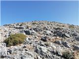 | Kosmadei - Zastano (Samos) (no. 11 / 10)
Zastano (Gr. Ζάστανο), also Zestani (Gr. Ζεστάνι), is at 1,206 m the second-highest mountain on the Greek island of Samos. It is located in the K...
3 h 10 min |
 | Marija Reka (Koritnikov most) - Homič (on logging trail)
Homič is one of the peaks on the Prebold mountain trail, located northwest of the slightly higher and more famous Mrzlica. From the summit, where...
2 h 30 min |
| Marija Reka (Koritnikov most) - Homič (via Kriška planina)
Homič is one of the peaks on the Prebold mountain trail, located northwest of the slightly higher and more famous Mrzlica. From the summit, where...
2 h 40 min |
| Matke - Homič (past Kočet and on logging trail)
Homič is one of the peaks on the Prebold mountain trail, located northwest of the slightly higher and more famous Mrzlica. From the summit, where...
2 h 25 min |
| Matke - Homič (via Kočet and Kriška planina)
Homič is one of the peaks on the Prebold mountain trail, located northwest of the slightly higher and more famous Mrzlica. From the summit, where...
2 h 35 min |