Starting point: Gabrje (400 m)
| Latitude/Longitude: | 45,7778°N 15,2753°E |
| |
Walking time: 2 h
Difficulty: easy marked way
Elevation gain: 778 m
Elevation difference along the route: 778 m
Map: Dolenjska 1:50.000
Recommended equipment (summer):
Recommended equipment (winter):
Views: 94.733
 | 4 people like this post |
Access to starting point:
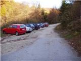
From Novo Mesto or Otočec, drive to the village of Velike Brusnice. Continue following the road towards the village of Gabrje. In the center of Gabrje village (just after the guesthouse), we reach a junction, where we continue straight in the direction of Šumeči potok (street name). At the end of the street, we will notice a large parking lot and next to it signposts for Gorjanci.
Route description:
From the end of the parking lot, continue along the right road towards Gorjanci. After just a few steps, the road reaches the next junction; continue left along the upper road, which becomes increasingly rough and leads us across a meadow into the forest. The road, which in the meantime has turned into a cart track, begins to ascend. During the ascent, the cart track has quite a few forks, so carefully follow the markers that safely lead us upwards. The cart track then gradually turns into a footpath, which a little higher takes us across a scenic meadow from which, with good visibility, we get a view towards the Kamnik and Savinja Alps. The path then ascends more steeply for a short time and leads us over a bridge across a small stream. Only a few dozen steps of walking remain, and the path brings us to the Gospodična spring. Here, continue right along the path, which after a few gentle steps brings us to the mountain hut.
From the hut, continue right along the road, which ascends and after a few dozen steps brings us to another road. Here, continue right for about another minute to the place where the sign for Trdinov vrh directs us left upwards. The path then leads us, with a moderate ascent, to an indistinct side ridge, which the path soon leaves and a little higher brings us to a forest road. The footpath merely crosses this road and continues gently ascending through the forest. Further on, the path descends slightly for a short time and brings us to a forest road. Follow this road for just over 100m to the place where the footpath branches off right upwards. Continue along the fairly steep path, which after just over five minutes brings us to Trdinov vrh.

Photos:
 1
1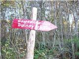 2
2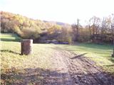 3
3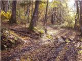 4
4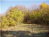 5
5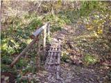 6
6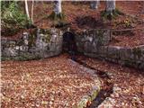 7
7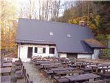 8
8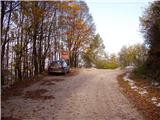 9
9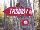 10
10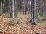 11
11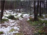 12
12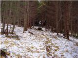 13
13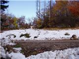 14
14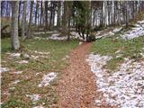 15
15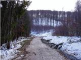 16
16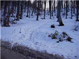 17
17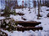 18
18 19
19
Discussion about the trip Gabrje - Trdinov vrh
|
| Gost14. 11. 2007 |
You can extend the trail by about an hour if you descend first past Krvavi kamen to Miklavžev dom and then past Gospodična back to Gabrje.
|
|
|
|
| Parkeljc28. 02. 2010 |
We also reach the mentioned starting point from the Metlika direction, specifically so we don't unnecessarily drive to NM or Otočec, when we start descending from Vahta towards NM, we soon come to the turn-off for DOLŽ. We drive through Vrhe, Dolž, then Pangrč grm, where we follow the sign for Gabrje. In the village Gabrje we reach the priority road, turn right, then follow the sign for Šumeči potok. On Friday I was at Trdinov vrh, where there is still up to half a meter of snow in places. The view towards NM was nice from the top, and the Alps with Ojstrica, Karavanke with Stol, Storžič, Kočna and Kamnik-Savinja Alps were clearly visible. I do not recommend the other two paths (by car), because you don't get far, except with 4x4 drive! The road is plowed to the top, but icy.
|
|
|
|
| rjudnic28. 02. 2010 |
Where is the starting point for the path to Trdinov vrh from Jugorje. And how long does it take and is it marked.
|
|
|
|
| mary3. 11. 2011 |
I'm interested in how long the circular path from the starting point Gabrje to Trdinov vrh past Doma pri Gospodični and then to Sv. Miklavž and Krvavi kamen back to the starting point takes? Thanks, Lp
|
|
|
|
| tisa3. 11. 2011 |
@mary just keep an eye on the path under your feet, the day is still long enough that you'll manage this path. Time is always relative, some walk faster, others slower. In my estimation 4-5 hours.
|
|
|
|
| MEHOVO3. 11. 2011 |
..I fully agree with TISO, it depends on whether you intend to enjoy it nicely, or just want to walk the path, then with good condition it can also be done under 3 hours 
|
|
|
|
| nanica3. 11. 2011 |
For this path it will take approximately 4 hours. Mehovo-under 3 hours for this path would be quite tough, except for you who is carried as if on a jet engine (you have to take this as a compliment, not as teasing)
|
|
|
|
| Kokta17. 12. 2011 |
Today I walked this wonderful path through freshly fallen snow. The path is very well marked despite being snowy. I also have to praise the kitchen and staff at the mountain hut at Gospodični, all 5s. As someone once said....the snowy path to the top of Trdinov vrh imprints itself in your soul ...recommend..lp
|
|
|
|
| sduli27. 02. 2012 |
On Saturday, 25.2.2012 I was at the top. Abnormally high temperature, so snow melting fast, slushy. Otherwise gorgeous sunny day, unique view. Also must mention borovničevec and wild boar goulash at Gospodična, very tasty. Praise to all active in those parts. I'll come again...recommend...
|
|
|
|
| Domch1. 03. 2012 |
On Wednesday 29.02.2012 I was at the top. The path is muddy below Gospodično and also very icy, the same applies to the last part of the path, microspikes are useful in places.
|
|
|
|
| gonzales1. 03. 2012 |
Trail description for Mr. Rjudnic, who is interested in the trail from Jugorje near Metlika towards Trdinov vrh.
You can leave the car right at the Badovinac inn, then walk along the main road to the first path sharply right (less than 100 meters further), then just follow the markers, pay attention to them because they can be sparse in certain places!!
The trail is nicely varied, suitable for this time of year, mainly because there is no greenery yet and the markers are visible from a greater distance. You arrive at a gravel road that leads from Vahta towards the mountain hut Gospodična, then continue along this path for about 500 meters to the direction sign that marks the steep path to the summit!!! Expect to be at the top in under 4 hours, depending on fitness, number of participants, number of stops, bla bla bla......!!
Take sufficient amount of liquid.
Regards
|
|
|
|
| Domch2. 03. 2012 |
As for the stamp at the summit, it's worth all the criticism (PD Krka should fix it), next to Olševa it's the worst stamp I've seen.
|
|
|
|
| lakkon10. 07. 2012 |
If the weather is OK for about 4 hours, I'd go to Trdinov vrh this week for a lighter training before the challenges that the 2000ers offer soon. According to the last post here: will I get a reasonably decent stamp imprint in my new booklet?
|
|
|
|
| Janiel7410. 07. 2012 |
Nicely get an ink pad and carry it with you all the time
|
|
|
|
| rudibr3. 01. 2014 |
Who is actually the organizer of the winter hike or ascent to Trdinov vrh. This year it will be on 4. 1. 2014. Is it PD Novo mesto or someone else?
|
|
|
|
| 75'er3. 11. 2014 |
If anyone from PD RTV reads this, the rubber part of the hiking trail stamp after the transmitters is missing, so it cannot be stamped.
|
|
|
|
| julius9. 11. 2014 |
This part of the stamp has been missing since mid-May, so it's obvious that no one from PD RTV reads this forum.
|
|
|
|
| Pelca17. 09. 2016 |
Today I was at Trdinov vrh, the stamp is acceptable, but you need to bring your own ink pad. But I would praise the service and offer at Dom na Gospodični - top-notch!
|
|
|
|
| anazala26. 11. 2017 |
Trdinov vrh is a nice mountain viewpoint. Nice view. Not a demanding trail. It's for young and older hikers. However, the food has worsened in both huts because of new owners. I'll eat my own snack from the backpack. It was expensive, but it didn't bother me because the food was tasty and service great. Now that's no longer the case. 
|
|
|
|
| potpodnoge30. 11. 2017 |
Just under a month ago (18.10.17) my wife and I took the same trail. The lady serving was friendly and we agreed that upon our return from Trdinov vrh, mushroom soup would wait for us. She only asked us to remind her that the dish was reserved. On the way back we got excellent mushroom soup with really lots of mushrooms. Tasty and good, lady friendly. So we had a really good feeling and a nice day. Of course, I can't judge what others experience, as people's moods aren't always the same. Anyway, we left the mountain hut at Gospodični in very good spirits.
|
|
|
|
| Peter 718. 07. 2022 16:15:36 |
Today my son and I were at Trdinov vrh, it was great, weather great high clouds and low temps for July. But I'm still not okay with it, on the path there was a thrown plastic bottle on the ground, and lots of trampled paths outside the marked trail. Why do you go to the mountains those who don't stick to the marked path? It's not good to destroy the undergrowth in the forest and cause damage, because some of you are not able to walk on the marked path!
|
|
|
To post a comment you must log in:
If you do not yet have a username, you must first
register.