Rakov Škocjan - Veliki Javornik (Javorniki)
Starting point: Rakov Škocjan (550 m)
| Latitude/Longitude: | 45,7886°N 14,2979°E |
| |
Walking time: 2 h
Difficulty: easy marked way
Elevation gain: 718 m
Elevation difference along the route: 718 m
Map: Snežnik 1:50.000
Recommended equipment (summer):
Recommended equipment (winter): ice axe, crampons
Views: 27.330
 | 1 person like this post |
Access to starting point:
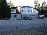
A) From the Ljubljana–Koper motorway, take the Unec exit and continue driving towards Unec. In Unec, signs for Postojna and Rakov Škocjan direct us to the right onto the road, which a little further continues directly alongside the motorway. After a few kilometres from Unec, we arrive at a junction, where signs for Rakov Škocjan direct us left onto a gravel road, along which we then drive to Hotel Rakov Škocjan.
B) From the Koper–Ljubljana motorway, take the Postojna exit, then continue driving along the old road towards Logatec. When Postojna ends, at the hamlet of Ravbarkomanda turn right in the direction of Unec, Rakek and Rakov Škocjan. After crossing the railway track via the overpass, continue left on the main road, then through the underpass under the motorway reach the other side of the motorway. We drive alongside the motorway for some time, then signs for Rakov Škocjan direct us left onto a gravel road, along which we then drive to Hotel Rakov Škocjan.
C) First, drive to Cerknica, from there continue driving towards Unec. In the settlement of Podskrajnik continue left towards Rakov Škocjan, Zelše and the industrial zone. At the unmarked junction in the industrial zone continue straight, then quickly arrive at the settlement of Zelše. When the settlement ends, the asphalt soon ends too, and the road brings us to a junction, where to the right branches a road to the Hunting Lodge LD Cerknica, while we continue straight and drive on to Hotel Rakov Škocjan.
Route description:
At the end of the parking lot, we notice signs for the footpath to Javornik. The path initially runs along the road between individual houses, then the road ends. We continue along a poorly marked cart track in the direction of Veliki Javornik. After a few minutes of walking, the cart track turns into a barely visible path, which after a few minutes of steep ascent brings us to a forest road, which we follow to the left. After less than 100 m of walking along the road, we reach a junction, where we continue sharply right along the road, which ascends gently. After a further 15 minutes of walking, we reach the next junction, where we continue along the left road. We follow this road to the point where a footpath branches off to the right upwards (here the path from Cerknica also joins us).
The path ahead climbs steeply up the slope almost straight upwards and after 10 minutes brings us to a forest road. We follow it to the right for just a minute, then the markers direct us steeply upwards to the left. The path initially climbs straight up the slope, then turns slightly to the right and for a short time climbs even more steeply. The steepness then eases, and the path brings us in a moderate ascent to the summit of Veliki Javornik.
PS: The entire path runs through forest with a large population of brown bears.

Photos:
 1
1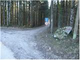 2
2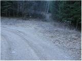 3
3 4
4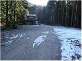 5
5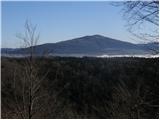 6
6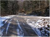 7
7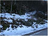 8
8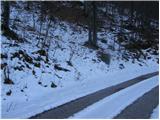 9
9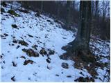 10
10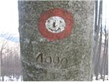 11
11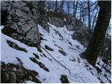 12
12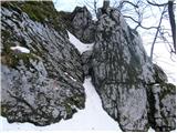 13
13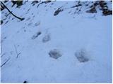 14
14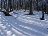 15
15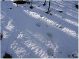 16
16 17
17
Discussion about the trip Rakov Škocjan - Veliki Javornik (Javorniki)
|
| Planinček25. 02. 2008 |
Solitary path without major views. The path is very steep, poles are very useful. I think this path is more suitable in summer by bike, when you can ride along the forest road in pleasant shade to the top.
|
|
|
|
| ulmusglabra21. 12. 2011 |
Yesterday I went up, I really like this hike because it's secluded and there's lots of forest. But there are really many bear tracks!
Not much view, best is a few meters below the summit (at ca. 1100 m), where due to some fallen beeches a "window to the world" opens; you can see Slivnica and Cerkniško jezero, yesterday the mountains and all hills on the Notranjska side looked fantastic. On top approx. 20 cm snow, at 1 pm around -5°C.
This winter it will definitely be my target destination multiple times 
|
|
|
|
| ulmusglabra21. 12. 2011 |
Aha, Planinček, I agree with you; Javorniki are very suitable for cycling in summer, when it's nicely cool and shady here
Forest roads are in very good condition, only on the less used ones there are often stones or even rocks on the track that break off from the steep slope above the road... and caution is needed when descending by bike.
I myself mostly go up from Kalič or Rakov Škocjan, then from Vrh along the ridge or to the Cerkniško, Postojnsko or, most often, Pivška side (Trnje, Palčje)
LP
|
|
|
|
| agadir5. 09. 2015 |
The path from Rakov Škocjan is (was) partially or completely impassable due to the consequences of the ice storm, the markings are also lost and the path needs to be remarked or marked again. But there is also a path from Dolenja vas (near Cerknica) and I can't find it described anywhere, it is also marked
|
|
|
|
| Am Shagar24. 09. 2015 |
Yes there is also a path from Dolenje vas and from Rakek, but question is what condition they are in. Most reliable would be to go by road (gravel turnoff right after as I remember). Definitely recommend using a map. Otherwise best by bike in summer. Road leads past military object below summit from which it's another 5 minutes to the top.
|
|
|
|
| Am Shagar24. 09. 2015 |
After the turnoff for Kalič I forgot to add.
|
|
|
|
| rmitja3. 03. 2025 10:13:21 |
The path is very nicely marked (from Rakov Škocjan), practically impossible to miss. It is true that the second half of the ascent is very steep. Those dangerous climbing sections can also be easily avoided, especially now in winter there is a clearly visible path to the left of the rocks (with even some steps in between).
Rakov Škocjan - Veliki Javornik - Česnovo sedlo - Poljane
|
|
|
To post a comment you must log in:
If you do not yet have a username, you must first
register.