Škofja Loka (Vincarje) - Lubnik (ridge path)
Starting point: Škofja Loka (Vincarje) (356 m)
| Latitude/Longitude: | 46,1698°N 14,2975°E |
| |
Route name: ridge path
Walking time: 2 h 15 min
Difficulty: easy marked way
Elevation gain: 669 m
Elevation difference along the route: 669 m
Map: Škofjeloško in Cerkljansko hribovje, Kod-Kam, Izletniška karta, 1:50.000
Recommended equipment (summer):
Recommended equipment (winter):
Views: 59.219
 | 3 people like this post |
Access to starting point:
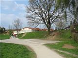
We drive to Škofja Loka and continue driving in the direction towards Selška dolina (or Stara Loka), but only to the beginning of Podlubnik - we drive past the Poden hall and a little after that, at the intersection we turn left into the Podlubnik settlement and look for a parking spot near the Najdihojca kindergarten (Podlubnik 1D), or we drive past this parking lot a little further on the first street to the right and when we notice a turn-off of a narrow path to the left, we turn onto it and drive about 100 m. Just before the path ends before a small bridge (only for pedestrians) over Selška Sora, we will see a small parking lot for about 5 cars on our left side, where we park. If we park near the kindergarten, we go to the end of the path next to it and get to a footpath which leads us a little downhill, a few meters to the mentioned small parking lot.
Before the trip I recommend viewing the location on the map najdi.si or Google Maps.
Officially the marked path from Vincarje starts at the Mini hotel (which from the footpath by Sora we see on a somewhat distant hill above the settlement) and then on the path through a meadow by the edge of the forest descends to Selška Sora, where it joins the path described above.
Route description:
From the parking lot, we go to a few meters distant small bridge over Selška Sora, which we cross and right behind the bridge we turn right onto a footpath which leads by the riverbed. We are on an area named Vincarje. On our left we have at first a meadow and then a field, and soon we notice on the opposite bank of Sora a small hydropower plant, past which we go. We still walk on a footpath and later on a wider path by the riverbed, until we notice on a tree by the path on the right side a signpost for Lubnik already quite bark-covered, which points us uphill to the left. The path, which is moderately ascending, is at the beginning almost invisible (because of the fallen leaves), but it is well marked (blazes on the trees). We walk through a thin forest, after about 15 minutes of walking the path becomes more visible and we soon come to a crossing, where in front of us we see two signposts - right shows the path to Lubnik on the ridge and on the left is written only "Lubnik", and a little ahead on a tree by the footpath in this direction there is a caption "Gabrovo".
We go on the right footpath (Lubnik po grebenu - Lubnik on the ridge), which for some time still moderately ascends through a thin forest and then becomes steep and rocky and on the ridge first brings us to Mali Lubnik, from which we then descend a little and then again ascend to the destination. In the last part of the path our path joins the path which brings to Lubnik from Gabrovo.

Along the route: Mali Lubnik (894m)
Photos:
 1
1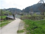 2
2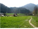 3
3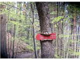 4
4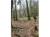 5
5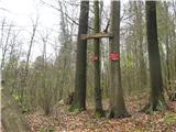 6
6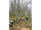 7
7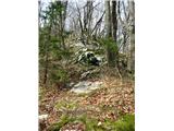 8
8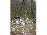 9
9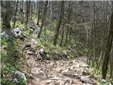 10
10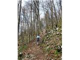 11
11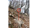 12
12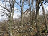 13
13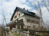 14
14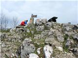 15
15 16
16 17
17
Discussion about the trip Škofja Loka (Vincarje) - Lubnik (ridge path)
|
| omen21. 05. 2010 |
Been up there today...the path is well marked and trodden...just don't know where you got 2h 15 min (maybe family with 5 year old kid) I needed 1h 10 min!
|
|
|
|
| Kriška21. 05. 2010 |
Nice, congratulations. As you can see on the signpost for Lubnik (photo 4), which you see after walking the mentioned path for a while, from that signpost it's still 1 h 40 min along the ridge path to the summit. Also according to the old rule (300 elevation m = 1 h, + distance) the stated times "fit". Of course, individual deviations can always be large everywhere, which is why it has been emphasized several times in many places that the marked times (in these descriptions, on signposts, in books) are orientational; they must of course follow some rule.
|
|
|
|
| Branee22. 07. 2010 |
Hi, It takes me from Škofja Loka (from home in the center to the top less than an hour, it's true I go straight, without any extras). I do the tour without a sip of water and it's extremely easy, I go along the ridges.
|
|
|
|
| Jože.22. 07. 2010 |
I needed 1h 10 min! ; I need from Škofja Loka to the top less than an hour ......( What's the title of this section again? EXCURSIONS or competition )
|
|
|
|
| Kokta31. 12. 2011 |
Well, I started at Loški grad and planned to go past Stari grad to Lubnik. But since there are almost no markers and direction signs at the beginning of the trail, I quickly missed the path. Luckily, friendly locals directed me on another path to the bridge in the valley, where once you enter the forest the trail is well marked. So I ended up on the ridge trail. The trail is quite icy and steep, so I don't recommend returning the same way. At the top there is really a wonderful view and good service at the hut. For the return I decided to take the path past Stari grad. That's the path I wanted to take up. Note for those not from around here: Stari grad is not Loški grad, which can be misleading on the way back. Stick to the path towards Škofja Loka. Also, a direction sign would be welcome closer to Gaberje. And one more thing... when you leave the forest at the end and reach the meadows, there's no sign again. Here you're left to wander again. In short, the lower part of the path past Stari grad is not fully marked. Those responsible for marking in Škofja Loka... please sort this out for visitors who are not from here.
|
|
|
|
| Darxta30. 12. 2012 |
2h 15min is quite realistic time for a normal hiker. I needed almost that much from the center of Loka (slightly longer path), but with my wife it would definitely take that much on the described path.
Otherwise congratulations to all who make it to the top in a good hour!
I would warn that on the ridge path from the Lubnik/Gabrovo junction there are a couple of fallen trees and lots of branches, requiring a bit more effort due to breaking through obstacles and low bushes. If anyone reads this - need to clear the path a bit
|
|
|
|
| darh1. 06. 2013 |
We returned to Škofja Loka via this path today (for the ascent we chose the path via Luža). The markings are definitely more frequent in the ascent direction than descent, but we had no problems with orientation anyway. However, after heavy rain, it's easy to slip: both on rocks and roots in the upper part and on leaves and ground in the lower. Until the terrain dries at least a bit, this path is certainly not an ideal choice for descent. Here you can read the full path description with pictures.
|
|
|
|
| fonko22. 06. 2015 |
Today I walked this trail. As previous ones wrote, the trail is not suitable for descent. At the top there were lots of noisy dogs and children. Congratulations to all who do this trail in one hour and ten minutes. Nice regards.
|
|
|
|
| robi210727. 12. 2015 |
Today we hiked this trail. It's quite steep, but our five-year-old managed it with some help. The trail is well marked and trodden enough to follow without issues. For the entire trail from the parking lot at the kindergarten to the top, we took about 2.5 hours. We descended via Gabrovo, turned left towards Stari grad, then down path ID 403 to Vincarski potok and back to the start. Downhill is also well marked, in places quite steep and especially from the junction for Gabrovo towards Stari grad (section ID 402) also muddy, even though it hasn't rained for a while. There was some fallen wood on this section, but nothing special.
During the ascent I managed to lose an older Nokia phone, black-gray color, a bit battered and with a missing side cover (where it charges). The phone itself is worthless, but I'd appreciate the SIM card for the phone numbers. I ask the honest finder to contact me via ZS.
|
|
|
|
| KarmenT25. 02. 2022 15:24:34 |
The elevation gain listed on the path is not accurate. The ridge or ridges rise and descend slightly several times. Otherwise, the path along the ridges before the trees bud is very beautiful, scenic, somewhat solitary, easy to follow and well marked.
|
|
|
|
| navdušena13. 02. 2023 08:05:34 |
Oh, those time estimates, records etc. Yesterday I walked the path from Najdihojca kindergarten to the hut. Nice, about two hours. The stated time is quite accurate. Jože, Branee with 1 hour or 1 hour 10 minutes - is that a moderate pace? And is it recommended to go on the trail without a sip of water? Kriška, you're right, times are indicative and I'm sure someone could manage the trail maybe in 48 minutes. But not me and many others either!
|
|
|
|
| J.P.29. 10. 2023 18:32:29 |
We always put Lubnik on the list "for bad weather time" and lack of time. We will definitely return several times as the trail really excited us - very nice, steep, uncrowded. For the return we went through Gabrovo, around Stari grad to the starting point at the Najdihojca kindergarten. With this we closed a nice loop, which I recommend especially in wet and slippery conditions. Lp
|
|
|
To post a comment you must log in:
If you do not yet have a username, you must first
register.