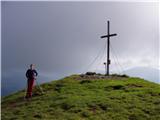
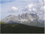
 | Planina Jezerca - Veliki Zvoh (via Dom na Krvavcu)
Veliki Zvoh is the highest point of the Krvavec ski resort. The cable car does not quite reach the summit but stops only a few metres short. A fe...
1 h 40 min |
 | Pri Rupah - Mrežce (direct way)
Mrežce is a panoramic peak near Lipanski vrh, which is visible on the other side of the gully between the two peaks. Since the slopes towards Pok...
1 h 40 min |
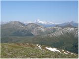
| Rudno polje - Mrežce
Mrežce is a panoramic peak near Lipanski vrh, which is visible on the other side of the gully between the two peaks. Since the slopes towards Pok...
2 h 40 min |
 | Pri Rupah - Lipanski vrh
The panoramic Lipanski vrh is located above the Blejska koča on the Lipanca mountain pasture. From the summit, which drops steeply towards the Kr...
1 h 45 min |
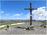
 | Medvedova konta - Debela peč
Debela peč is a 2014 m high mountain that rises steeply above the Krma valley on one side and gently descends towards the expansive Pokljuka fore...
2 h 15 min |
 | Strmec - Debela peč
Debela peč is a 2014 m high mountain that rises steeply above the Krma valley on one side and gently descends towards the expansive Pokljuka fore...
2 h 30 min |
 | Strmec - Debela peč (old path)
Debela peč is a 2014 m high mountain that rises steeply above the Krma valley on one side and gently descends towards the expansive Pokljuka fore...
2 h 15 min |
 | Sviščaki - Snežnik (footpath)
Snežnik, or Veliki Snežnik, at 1796 metres is the highest peak in the near and far surroundings, offering a beautiful view over a large part of S...
2 h |
 | Gašperjev hrib - Snežnik
Snežnik, or Veliki Snežnik, at 1796 metres is the highest peak in the near and far surroundings, offering a beautiful view over a large part of S...
1 h 30 min |
 | Gašperjev hrib - Snežnik
Snežnik, or Veliki Snežnik, at 1796 metres is the highest peak in the near and far surroundings, offering a beautiful view over a large part of S...
1 h 30 min |
 | Sviščaki - Snežnik (variant through forest)
Snežnik, or Veliki Snežnik, at 1796 metres is the highest peak in the near and far surroundings, offering a beautiful view over a large part of S...
2 h |
| Sežanje - Snežnik
Snežnik, or Veliki Snežnik, at 1796 metres is the highest peak in the near and far surroundings, offering a beautiful view over a large part of S...
1 h 40 min |
 | Sviščaki - Snežnik (by road)
Snežnik, or Veliki Snežnik, at 1796 metres is the highest peak in the near and far surroundings, offering a beautiful view over a large part of S...
1 h 55 min |
| Sviščaki - Snežnik (via Mali Snežnik)
Snežnik, or Veliki Snežnik, at 1796 metres is the highest peak in the near and far surroundings, offering a beautiful view over a large part of S...
2 h 15 min |
 | Planina Loka - Velika Raduha
Velika Raduha, at 2062 m, is the highest peak of the Raduha range, which rises steeply east of Robanov Kot. From the summit, with its registratio...
1 h 55 min |
 | Snežna jama - Velika Raduha
Velika Raduha, at 2062 m, is the highest peak of the Raduha range, which rises steeply east of Robanov Kot. From the summit, with its registratio...
1 h 45 min |
 | Križovec - Kahlkogel/Golica (via mountain hut)
Golica is a treeless peak located north of Jesenice. The summit features a registration box and offers a beautiful view of the western Karawanks ...
2 h |
 | end of road on Vogar - Pršivec (direct way)
Pršivec is a panoramic mountain above Lake Bohinj. The view is extensive in all directions: Triglav and the surrounding mountains are clearly vis...
1 h 30 min |
| end of road on Vogar - Pršivec (via planina Viševnik)
Pršivec is a panoramic mountain above Lake Bohinj. The view is extensive in all directions: Triglav and the surrounding mountains are clearly vis...
2 h 20 min |
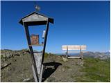
 | Medvedova konta - Brda (west path)
Brda is a panoramic peak situated between Pokljuka and Krma. The summit has a stamp attached to a metal pole and offers a beautiful view towards ...
2 h |
| Medvedova konta - Brda (east path)
Brda is a panoramic peak situated between Pokljuka and Krma. The summit has a stamp attached to a metal pole and offers a beautiful view towards ...
2 h |
 | Pri Rupah - Brda (west path)
Brda is a panoramic peak situated between Pokljuka and Krma. The summit has a stamp attached to a metal pole and offers a beautiful view towards ...
2 h |
 | Pri Rupah - Brda (east path)
Brda is a panoramic peak situated between Pokljuka and Krma. The summit has a stamp attached to a metal pole and offers a beautiful view towards ...
2 h |
 | Planina Dol - Konj
Konj is an 1803 m high peak located between Velika Planina and Presedljaj. From the summit there is a beautiful view of the highest peaks of the ...
1 h 30 min |
 | Kriška planina - Vrh Korena (via Planina Koren)
Vrh Korena is located between Zvoh and Kalški greben near the Krvavec ski resort. The summit offers a beautiful view of the highest peaks in the ...
2 h 15 min |
| Dom na Gospincu - Vrh Korena (via Dolga njiva)
Vrh Korena is located between Zvoh and Kalški greben near the Krvavec ski resort. The summit offers a beautiful view of the highest peaks in the ...
2 h 25 min |
| Planina Jezerca - Vrh Korena (via planina Koren)
Vrh Korena is located between Zvoh and Kalški greben near the Krvavec ski resort. The summit offers a beautiful view of the highest peaks in the ...
2 h 30 min |
 | Kriška planina - Kompotela
Kompotela is a peak near Mokrica and Vrh Korena. The grass- and dwarf pine-covered summit offers a beautiful view towards Grintovec, Skuta, Brana...
2 h 15 min |
| Planina Jezerca - Kompotela
Kompotela is a peak near Mokrica and Vrh Korena. The grass- and dwarf pine-covered summit offers a beautiful view towards Grintovec, Skuta, Brana...
2 h 30 min |
 | Medvedova konta - Debeli vrh above Lipanca
Debeli vrh is a 1962 m high mountain located in the ridge that rises steeply above the Krma valley. From the summit, where a stamp is attached to...
2 h 15 min |
 | Ravne - Rosenkogel/Hruški vrh (direct way)
Hruški vrh is a 1776-metre-high mountain located between Dovška Baba and the lesser-known Klek. From the summit, where there is a small chapel de...
2 h |
 | Planina Ravne - Veliki vrh (Veža) (via Zelene trate)
Veliki Vrh is a 2,110-metre-high mountain located in the central part of the Dleskovec Plateau. From the summit, where there are two registration...
2 h 15 min |
 | Ski hotel Vogel - Šija
Šija is located above the Vogel ski resort in the Lower Bohinj Mountains. From the summit, there is a nice view of the neighboring peaks in the s...
1 h 30 min |
 | Sviščaki - Mali Snežnik
Mali Snežnik is a peak on the western ridge of Snežnik. Covered with dwarf pines, the summit offers beautiful views of the neighboring Veliki Sne...
1 h 50 min |
 | Eisenkappler Hutte - Hochobir (Ojstrc)
Ojstrc (Hochobir) is the highest peak of the smaller Obir range. It is located west of Železna Kapla (Eisenkappel) on the Austrian side of the Ka...
1 h 35 min |
 | Ski hotel Vogel - Vogel (via planina Zadnji Vogel)
Many associate the name Vogel first with the Vogel ski resort near the eponymous peak. From the north, it is recognizable by its pyramidal shape,...
2 h 30 min |
 | Planina Zapleč - Krasji vrh (via Koluji)
Krasji vrh is situated between Bovec and Kobarid on the Polovnik mountain ridge. At 1773 m it is also the highest peak of the mentioned ridge, so...
2 h |
| Planina Zapleč - Krasji vrh (via snežna jama)
Krasji vrh is situated between Bovec and Kobarid on the Polovnik mountain ridge. At 1773 m it is also the highest peak of the mentioned ridge, so...
2 h |
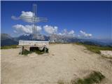
 | Winterleiten parking - Zirbitzkogel
Zirbitzkogel, at 2,396 m, is the highest peak of the Labotniške Alpe / Seetaler Alpen. From the summit, where a cross and a panorama board stand,...
2 h 17 min |
 | Tonnerhütte - Fuchskogel
Fuchskogel is a peak south of Zirbitzkogel in the Seetaler Alpen mountain group. The summit is broad and mostly covered in grass. More precisely,...
2 h 20 min |
 | Winterleiten parking - Scharfes Eck
Scharfes Eck is a peak on which stands an Austrian meteorological radar station. From the summit, there is a beautiful view of the neighbouring p...
2 h |
 | Walischeben - Weißenstein (Packalpe) (Direct way)
Weißenstein is a grassy mountain crisscrossed with wire fences. From its indistinct summit, there is a nice view of the neighboring Ameringkogel ...
1 h 45 min |
 | Walischeben - Ameringkogel (Packalpe) (Direct way)
Ameringkogel is a grassy summit with a cross and summit register. At 2,187 meters, it is the highest peak of the Packalpe. In good visibility, th...
1 h 55 min |
 | Walischeben - Großenberg (Packalpe) (via Ameringkogel)
Großenberg, also known as Größing, is the northernmost two-thousander in the Packalpe mountain group. From its expansive grassy summit, where a t...
2 h 25 min |
| Walischeben - Großenberg (Packalpe) (below the Ameringkogel summit)
Großenberg, also known as Größing, is the northernmost two-thousander in the Packalpe mountain group. From its expansive grassy summit, where a t...
2 h 20 min |
 | Walischeben - Hofalmkogel (Packalpe) (via Weissenstein)
Hofalmkogel is a less distinct peak in the ridge from Großenberg to Speikkogel. The summit is broad and mostly grassy. From the top, there is a b...
2 h 5 min |
 | Walischeben - Hofalmkogel (Packalpe) (past the cross)
Hofalmkogel is a less distinct peak in the ridge from Großenberg to Speikkogel. The summit is broad and mostly grassy. From the top, there is a b...
2 h 5 min |
| Salzstiegelhaus - Hofalmkogel (Packalpe)
Hofalmkogel is a less distinct peak in the ridge from Großenberg to Speikkogel. The summit is broad and mostly grassy. From the top, there is a b...
1 h 50 min |
 | Walischeben - Speikkogel (Packalpe)
Speikkogel is a spacious and grassy summit in the Packalpe mountain group. From the top, there is a beautiful view towards the Slovenian mountain...
2 h |
 | Zadnji travnik - Govca (Olševa)
Govca is the highest peak of the Olševa range, rising above Koprivna, Solčava, and Remšenik (Remšenik/Remschenig is a valley on the Austrian side...
1 h 45 min |
 | Jezerski vrh - Kärntner Storschitz / Pristovški Storžič
Pristovški Storžič (Kärntner Storschitz) is an exceptionally panoramic peak above Jezersko. From it, there are fine views of the northern walls o...
1 h 50 min |
 | Plattner - Gartnerkofel (via Watschiger Alm)
Gartnerkofel is a 2,195-meter-high mountain in the Nassfeld ski area. Its Slovenian name is Krniške skale. From the summit, where a cross stands,...
2 h |
 | Planina Ravne - Velika Zelenica (via Zelene trate)
Velika Zelenica is the highest peak of the Dleskovška plateau, offering panoramic views accordingly. The nearby Ojstrica stands out most prominen...
2 h 15 min |
 | Dolinza Alm/Planina Dolnica - Starhand
Starhand is a panoramic peak in the eastern part of the Carnic Alps near the better-known Ojstrnik. From the top, there are beautiful views of th...
1 h 40 min |
 | Rosstratte - Dobratsch / Dobrač (by road)
Dobrač, or in German Dobratsch and also known as Villacher Alpen, is a 2166-meter-high mountain situated on the far eastern edge of the Gailtal A...
2 h |
 | Waldrast - Großer Speikkogel (Koralpe)
Großer Speikkogel is, at 2,140 meters, the highest peak of Golica/Koralpe, a range east of Volšperk/Wolfsberg. From the summit, where a cross and...
2 h |
 | Ladinger Straße - Speikkogel (Saualpe)
Speikkogel is an indistinct peak in the long ridge of the Svinja mountain pasture / Saualpe. From the spacious summit there is a beautiful view o...
2 h 25 min |
| Ladinger Straße - Speikkogel (Saualpe) (via Offnerhütte)
Speikkogel is an indistinct peak in the long ridge of the Svinja mountain pasture / Saualpe. From the spacious summit there is a beautiful view o...
2 h 35 min |
| Ladinger Straße - Speikkogel (Saualpe) (via Zechhütte)
Speikkogel is an indistinct peak in the long ridge of the Svinja mountain pasture / Saualpe. From the spacious summit there is a beautiful view o...
2 h 20 min |
 | Ladinger Straße - Großer Sauofen (Saualpe)
Großer Sauofen is, due to its location and shorter precipitous southwestern wall, one of the more prominent peaks on the Svinja / Saualpe mountai...
2 h 30 min |
| Ladinger Straße - Großer Sauofen (Saualpe) (via Offnerhütte)
Großer Sauofen is, due to its location and shorter precipitous southwestern wall, one of the more prominent peaks on the Svinja / Saualpe mountai...
2 h 40 min |
| Ladinger Straße - Großer Sauofen (Saualpe) (via Zechhütte)
Großer Sauofen is, due to its location and shorter precipitous southwestern wall, one of the more prominent peaks on the Svinja / Saualpe mountai...
2 h 25 min |
 | Turracher Höhe - Rinsennock (northern way)
Rinsennock is a 2,334 m high peak located in the heart of the Gurktal Alps. From the summit, where a cross stands, there are fine views ranging f...
1 h 45 min |
| Turracher Höhe - Rinsennock (southern way)
Rinsennock is a 2,334 m high peak located in the heart of the Gurktal Alps. From the summit, where a cross stands, there are fine views ranging f...
1 h 45 min |
 | Heidi Alm - Klomnock
Klomnock is the house mountain of the Nockalmstraße alpine road, leading to the Schiestelscharte pass (2,024 m). From the summit, where a cross s...
2 h 15 min |
 | Turracher Höhe - Gruft
Gruft is a grass-covered peak located southeast of the Turracher Höhe pass in the heart of the Gurktal Alps. From its 2,232 m high summit there a...
1 h 45 min |
 | Turracher Höhe - Kaserhöhe
Kaserhöhe is a panoramic peak located in Austrian Carinthia in the heart of the Gurktal Alps. On the spacious summit, which is partly covered in ...
2 h 20 min |
 | Sporthotel Maltatal - Arlhöhe
Arlhöhe is an inconspicuous peak located north of the Kölnbreinspeicher reservoir (above the Maltatal valley). The summit features a panorama boa...
1 h 45 min |
 | Pri Rupah - Okroglež
Okroglež is a peak covered with dwarf pines, located between Debela peč and Brda. From the summit, which has a stamp (no logbook), a nice view op...
1 h 55 min |
 | Bukovnik - Lanež
Lanež is a less distinct peak on the eastern part of Raduha. From the spacious summit a nice view opens on nearby Mala Raduha, Olševa, Peca, Uršl...
2 h 20 min |
 | Mangartska planina - Šober / Monte Sciober Grande (via Stože)
Šober / Monte Sciober Grande is a 1,845 m high peak located between the Remšendol Valley and Jezerska Valley. From the summit there is a fine vie...
2 h 20 min |
 | Planina Podvežak - Mala Ojstrica
Mala Ojstrica is an indistinct peak located between Ojstrica, Molička Planina mountain pasture, and Korošica. From the summit, which features a l...
2 h 30 min |
 | Rifugio Selvapiana I.Lunelli - Belvedere (Creston Popera)
Belvedere is a 2,125-meter peak on the slopes of the Creston Popera ridge, a known battlefield from World War I. The summit features a stone semi...
1 h 40 min |
 | Heidi Alm - Schwarzkofel (ridge path)
Schwarzkofel is a 2168 m high peak located south of the Heidialm pasture. From the summit, where a small cross stands, a fine panorama opens up o...
2 h |
| Heidi Alm - Schwarzkofel (via Falkertscharte)
Schwarzkofel is a 2168 m high peak located south of the Heidialm pasture. From the summit, where a small cross stands, a fine panorama opens up o...
2 h 5 min |
 | Heidi Alm - Rodresnock (ridge path)
Rodresnock is a 2310 m high mountain rising southwest of Lake Falkertsee. From the summit, where a large cairn stands with a cross in its center,...
1 h 30 min |
 | Heidi Alm - Rodresnock (via Falkertscharte)
Rodresnock is a 2310 m high mountain rising southwest of Lake Falkertsee. From the summit, where a large cairn stands with a cross in its center,...
1 h 30 min |
 | Heidi Alm - Falkert (via Falkertscharte)
Falkert is a 2308 m high peak located west of the village and Lake Falkertsee. From the summit, which has a few benches, a summit logbox with sta...
1 h 30 min |
 | Heidi Alm - Falkert (via Hundsfeldscharte)
Falkert is a 2308 m high peak located west of the village and Lake Falkertsee. From the summit, which has a few benches, a summit logbox with sta...
1 h 30 min |
 | Heidi Alm - Mallnock
Mallnock is a 2226 m high peak located north of the settlement St. Oswald in the Krške Alpe. From the summit, where a cross stands, a beautiful v...
2 h 30 min |
 | Ciampac - Sas de Adam
Sas de Adam (also Sass de Dama) is a 2,430-meter-high peak situated north of the alpine valley Val Sen Nicolo. From the top, a nice view opens up...
1 h 40 min |
 | Rifugio Rio Gere - Rifugio Tondi
Rifugio Tondi is situated a few meters below the summit of Monte Ciasadio, the highest point of the Faloria ski slope. From the hut, there is a v...
2 h 15 min |
 | Weinebene - Hühnerstütze (Golica/Koralpe)
Hühnerstütze is a 1989 m high peak in the Golica / Koralpe range. From the indistinct, mostly grassy summit, nice views open up on Großer Speikko...
2 h |
 | parking below Weinebene - Hühnerstütze (Golica/Koralpe) (panoramic path)
Hühnerstütze is a 1989 m high peak in the Golica / Koralpe range. From the indistinct, mostly grassy summit, nice views open up on Großer Speikko...
2 h |
 | Gasthof Pfeifferstocker - Handalm
Handalm is a 1853-meter-high peak located north to northeast of the alpine pass Weinebene. From the grassy summit, which features small granite r...
2 h 15 min |
 | Hebalm (Gasthaus Zur Rehbockhütte) - Weberkogel
Weberkogel is a less prominent peak located north to northwest of the alpine pass Weinebene. On the 1805-meter-high summit stands a medium-sized ...
2 h 35 min |
| Weinebene Straße - Weberkogel
Weberkogel is a less prominent peak located north to northwest of the alpine pass Weinebene. On the 1805-meter-high summit stands a medium-sized ...
1 h 30 min |
| Gasthof Pfeifferstocker - Weberkogel
Weberkogel is a less prominent peak located north to northwest of the alpine pass Weinebene. On the 1805-meter-high summit stands a medium-sized ...
1 h 50 min |
 | Zettersfeld - Goiselemandl
Goiselemandl is a 2,433-meter-high peak in the Schober mountain group. The mountain is fairly well-visited due to its proximity to the cable car....
1 h 30 min |
 | Obertauern - Gamsleitenspitze
Gamsleitenspitze is a 2359-meter-high mountain in the Radstädter Tauern mountain group. From the summit, located above the Obertauern ski center,...
2 h |
 | Zadnji travnik - Obel kamen (Olševa)
Obel kamen is a 1,911-meter-high peak located in the ridge of Olševa. On the summit is a border stone marked RS XXII 1; a cross and summit logboo...
2 h 15 min |
 | Rifugio Fedare - Monte Pore
Monte Pore or Spiz de Poure is a 2,405-meter-high grassy peak located west of the Averau and Nuvolau summits. From the top, where a large cross s...
1 h 30 min |
 | Parking Muritzen - Source of Mur / Murusprung (via Sticklerhütte)
The source of the Mur lies at 1,898 m elevation in the Muhrtal (Murwinkel) valley on the eastern foothills of Mureck mountain (2,402 m) in the An...
2 h 15 min |
 | Klippitztörl - Forstalpe (Saualpe) (via Geierkogel)
Forstalpe is an indistinct peak in the massif of Svinška planina / Saualpe. The stamp for Forstalpe is located in an interesting natural window, ...
2 h 10 min |
| Klippitztörl - Forstalpe (Saualpe)
Forstalpe is an indistinct peak in the massif of Svinška planina / Saualpe. The stamp for Forstalpe is located in an interesting natural window, ...
1 h 40 min |
 | Klippitztörl - Kienberg (Saualpe)
Kienberg is a 2,050-meter-high peak in the massif of Svinška planina / Saualpe. From the grassy summit, a beautiful view opens up over a larger p...
2 h 20 min |
 | Passo Campolongo - Stores
Stores is a 2,185-meter-high peak on the southeastern part of the Pralongia plateau. From the grassy summit where a cross stands, there is a very...
2 h |
 | Wiesser Alm - Mirnock (Path 184)
Mirnock is a 2,110 m high isolated and highly panoramic mountain massif in Carinthia. It is part of the Nockberge group in the Gurktal Alps, loca...
1 h 30 min |
 | parking below Weinebene - Steinmandl (Golica / Koralpe) (via Grünangerhütte)
Steinmandl is a panoramic peak in the Golica/Koralpe range, where numerous stone cairns have been built....
1 h 40 min |
| Glashütten - Steinmandl (Golica / Koralpe)
Steinmandl is a panoramic peak in the Golica/Koralpe range, where numerous stone cairns have been built....
2 h 25 min |
 | Knödelhütte - Hirschegger Alm (southern peak)
The southern peak in the Hirschegger Alm ridge is located west of the settlement of Hirschegg. From the summit, where a cross stands, a beautiful...
1 h 35 min |
 | Knödelhütte - Hirschegger Alm (northern peak)
Hirschegger Alm (northern peak) is a 1,871-meter-high peak in the Packalpe mountain group. From the grassy summit, a beautiful view opens up all ...
2 h 25 min |
| Unterauerlinger Hütte - Hirschegger Alm (northern peak)
Hirschegger Alm (northern peak) is a 1,871-meter-high peak in the Packalpe mountain group. From the grassy summit, a beautiful view opens up all ...
2 h 15 min |
 | Salzstiegelhaus - Peterer Riegel
Peterer Riegel is a panoramic peak above the Peterer Sattel saddle. From the summit, where a cross stands and a bench sits below it, a beautiful ...
1 h 45 min |
 | Knödelhütte - Seinerkreuz
Seinerkreuz is a panoramic peak located above the Saureishütte hut and the settlement of Hirschegg. From the summit, a beautiful view opens up of...
2 h 40 min |
 | Waldrast - Steinschneider (by the edge of the Großes Kar plateau)
Steinschneider is a 2070-meter-high peak in the Golica / Koralpe mountain range, situated northwest of Großer Speikkogel, the highest peak of the...
2 h 20 min |
 | Hebalm (Gasthaus Zur Rehbockhütte) - Barofen
Barofen is a panoramic peak between the Weinebene Pass and the mountain road to Hebalm. On its 1,720 m high summit stands a cross with a summit r...
2 h |
 | Nassfeld - Garnitzenberg / Monte Carnizza (via Auernig Alm)
Krniška gora (Italian Monte Carnizza, German Garnitzenberg) is a 1950-meter-high mountain east of the Mokrine mountain pass. It is located on the...
1 h 50 min |
| Nassfeld - Garnitzenberg / Monte Carnizza (Auernig Höhenweg)
Krniška gora (Italian Monte Carnizza, German Garnitzenberg) is a 1950-meter-high mountain east of the Mokrine mountain pass. It is located on the...
2 h |
 | Kohlebnerstand - Windberg (northern path)
Windberg is a 1903-meter-high peak in the Schneealpe mountain group and, with its elevation, the highest peak of the group. From the summit, wher...
1 h 50 min |
| Kohlebnerstand - Windberg (southern path)
Windberg is a 1903-meter-high peak in the Schneealpe mountain group and, with its elevation, the highest peak of the group. From the summit, wher...
1 h 50 min |
 | Kohlebnerstand - Hoher Klapf
Hoher Klapf is a panoramic pathless peak in the Schneealpe mountain group, located near the group's highest peak, Windberg....
1 h 40 min |
 | Raxalm-Berggasthof (Rax) - Raxgmoahütte (Rax)
Raxgmoahütte is a hut owned by the Austrian mountain rescue service, open year-round as a bivouac or shelter. From the hut on top of a panoramic ...
2 h 15 min |
 | Seebergsattel - Seeleiten
Seeleiten is a panoramic peak with a cross on the Aflenzer Staritzen ridge, which belongs to the Hochschwab mountain group....
1 h 30 min |
 | Ladinger Straße - Sandkogel (via Zechhütte)
Sandkogel is an indistinct panoramic peak rising to 2011 meters in the Svinja range....
2 h 15 min |