Konec ceste na Vogar - Pršivec (direct way)
Starting point: Konec ceste na Vogar (1350 m)
| Latitude/Longitude: | 46,2956°N 13,8412°E |
| |
Route name: direct way
Walking time: 1 h 30 min
Difficulty: easy marked way
Elevation gain: 411 m
Elevation difference along the route: 411 m
Map: Triglav 1:25.000
Recommended equipment (summer):
Recommended equipment (winter): ice axe, crampons
Views: 59.756
 | 4 people like this post |
Access to starting point:
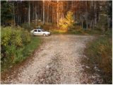
From the Ljubljana - Jesenice motorway, take the Lesce exit and follow the road towards Bled and further towards Bohinjska Bistrica. Continue driving towards Lake Bohinj (Ribčev laz), where we reach a junction, continuing right towards Stara Fužina. In Stara Fužina, at the junction by the chapel, turn sharply left onto the ascending road towards planina Blato, planina Vogar and Voje valley. The road then takes us to the toll and parking fee collection point, but we continue following it to the next junction, where we turn left (right Voje). Then follow the road to the next junction (we drive for quite some time), where we go straight ahead (sharply right planina Blato). Then follow the road past planina Vogar and drive along it to the parking lot at the end of the road.
Route description:
A few meters before the beginning of the parking lot, on the left side of the road (direction of ascent) we will notice a marked mountain path leading from Planina Vogar to Planina Viševnik. We descend a few steps along this path and it quickly brings us to a junction. We continue right towards Pršivec (left downhill Planina Vogar) along a cart track that ascends moderately, only occasionally somewhat steeper. A bit higher, the cart track turns into a footpath that is locally very steep, mostly ascending through dense spruce forest. Higher up the forest becomes sparser, larches increasingly joining the spruces, which with their colors enchant almost every mountaineer in autumn time.
The still steep path gradually passes onto a scenic ridge along which we then ascend. In wet and snow there is a risk of slipping on this section. The path, which offers beautiful views of the Bohinj - Tolmin mountains, sometimes called Lower Bohinj Mountains and central Julians, levels out somewhat and quickly brings us between individual trees to the scenic summit.

Photos:
 1
1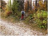 2
2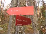 3
3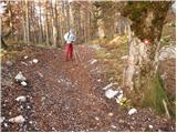 4
4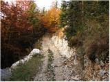 5
5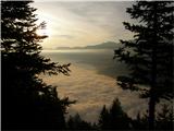 6
6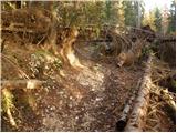 7
7 8
8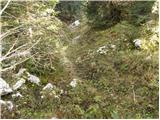 9
9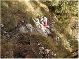 10
10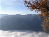 11
11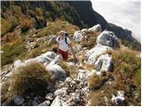 12
12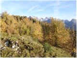 13
13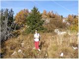 14
14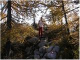 15
15 16
16
Discussion about the trip Konec ceste na Vogar - Pršivec (direct way)
|
| Tadej13. 10. 2008 |
Nice panoramic trail suitable for autumn days. On descent, somewhat greater caution is needed due to wet rocks and roots.
|
|
|
|
| AndrejK18. 07. 2009 |
Last Monday we ascended to Pršivec via planina Viševnik. We missed the direct path. We were enchanted by the wonderful views granted to us that day. We descended via the direct path to the parking lot at the end of the road. The path was dry, so no problems, but considerable caution is needed at some spots because the slope is very steep.
|
|
|
|
| pungi22. 10. 2009 |
Yesterday I had some difficulties descending from the viewpoint below the summit of Pršivec. Only after several returns to the marked path did I find the right descent path, which ran along an overhanging rock.
However, I really enjoyed watching our weekend house in Ukanc from a height of almost two thousanders. If I had a GSM with me, I would have called someone from the weekend house from that height.
|
|
|
|
| hribi22. 10. 2009 |
Maybe it doesn't really belong here, but with all these beautiful pictures and descriptions I often wonder who walks all these paths and then reports to us on this portal.
Congratulations to the editors.
|
|
|
|
| robi149. 05. 2011 |
On Saturday my girlfriend and I were on Pršivec via the direct path.
The path is dry overall, only in depressions there are still some snow patches.
The road is in excellent condition, as is the path to the summit.
In the forest to the top a wild grouse "greeted" me, and plenty of spring flowers with primroses at the fore.
At the top it was divine - peace, views and weather.
On the return we went past planina Viševnik, where on the path to the planina there's still quite some snow that sinks to your butt. On the meadow above planina Viševnik we searched for marmots, which were noisy but successfully hid...
All in all, a wonderful trip!
|
|
|
|
| _d_21. 10. 2012 |
It seems right to emphasize a bit the exposure and steep ascent several tens of meters before the summit itself. Otherwise, in good weather, as we had yesterday with the group, it is indescribably beautiful, but those with vertigo pass the last meters with great caution, even a bit of climbing is needed, poles were superfluous at that moment. We returned via the longer path over planina Viševnik, because vertigo did not "allow" friends to return via the direct one. Safety first! 
|
|
|
|
| lubi22. 10. 2012 |
Unforgettable. Yesterday we did a "loop" with a stop at the duty caretaker on Planina Viševnik. Mrs. Valerija made our day. The view of the lake from this perspective is even more impressive. We'll come again.
|
|
|
|
| lubi22. 10. 2012 |
To avoid misunderstanding; describing the view from Pršivec summit, not from safe high-alpine Planina Viševnik
|
|
|
|
| darh7. 07. 2013 |
On Wednesday we ascended to Viševnik via this trail. The views were truly magnificent, and the final exposed ascent was less problematic than expected, at least for the ascent in dry weather. We still didn't want to descend this way, so we returned via a somewhat less scenic but still nice trail through Planina Viševnik. A more detailed description of our route with photos is available here.
|
|
|
|
| kemator17. 10. 2014 |
Hello.
I'm interested if that exposed steep part along the ridge can be bypassed. Mihelič in the Julijske Alpe guidebook states: "a bit higher (already above the junction to Viševnik, n.n.) our path splits. The left trail clings to the steep, exposed ridge leading straight to the summit, the usual, easier path bypasses this steep section with a turn to the right".
Given that this "turn to the right" is neither mentioned in the path description nor in the comments, I'm wondering if it still exists at all and if it is marked.
Thanks for the answers and best regards.
|
|
|
|
| mornar11. 06. 2018 |
I'm interested in the conditions for the trail from Vogar to Pršivec.
|
|
|
|
| pojoča travica12. 06. 2018 |
The trail is still uncleaned in the lower part, there are still some fallen trees. From the parking lot onwards it is already arranged and normally passable.
|
|
|
|
| zacetnepoti7. 09. 2018 |
Hello!
I'm interested if the path is too steep for ascent with a baby carrier backpack?
Regards
|
|
|
|
| garmont7. 09. 2018 |
At some places you have to crawl under trees, so I think with a baby it will be quite a tough nut to crack.
|
|
|
|
| ND6. 07. 2020 |
I don't know what you consider under the term EASY MARKED PATH on the hribi.net portal, but the direct path to Pršivec (1:30h) is anything but easy. It is marked, that's true. The path is demanding, with sets of 3-4 pegs at three points, and the upper two sections involve exposed terrain. Unsuitable for a child in a backpack, also not suitable for families with small children who are not very experienced in mountains.
|
|
|
|
| pasmšu31. 07. 2020 |
Somewhere halfway along the path, logging and timber extraction is taking place. The path has become a forest skid trail. Walking in this direction is therefore less pleasant and idyllic than it used to be.
|
|
|
|
| lina1228. 07. 2021 13:53:37 |
Thinking it was an easy marked path, I set off for Pršivec in mid-July. The last half hour of this path is practically climbing. Just before the summit, I had to turn back because the terrain was completely exposed and so steep that I didn't dare continue.
|
|
|
|
| turbo29. 07. 2021 09:11:51 |
lina12,
don't take it to heart. We've all turned back already and will again sometime. At the beginning, because it seemed too hard and we lacked experience, later on some pathless terrain because we couldn't find the continuation, and all the time now and then because the weather turned and we fled to the valley or to a hut if it was nearby. This "belongs" to it, unfortunately. Or fortunately, because knowing when to turn back in time is a valuable experience. Just don't give up, the mountains are beautiful, surely there are tons of paths you're up to now and harder ones you'll manage later. Good luck
|
|
|
|
| potpodnoge30. 08. 2022 09:42:22 |
Turbo wrote it nicely, that's spot on. It's not success to reach the goal at any cost, but to be smart enough and know when to turn back. That's not defeat, that's a smart response to the situation one finds oneself in. Many lack that instinct sometimes because they only see the goal, then rescue operations, sick leave or something worse are needed. Mountains are beautiful, paths too, one just has to be aware that you're not in a valley park and know your abilities. No timely turnaround is bad, because mountains will remain, wait for the next visit, a person doesn't always have the luck to repeat the path. So no shame or reproaches when someone is convinced it won't go further, let them be satisfied that they knew to decide correctly and returned without the conquered goal, which will wait for next time.
|
|
|
|
| Kafetarca31. 08. 2022 08:38:17 |
Does anyone have photos of this steep climbing section? It's not noticeable from the description and photos.
|
|
|
|
| turbo31. 08. 2022 09:56:33 |
Photo 12 is somehow the most demanding part of the ascent. Very steep grass (knee-grinder), in wet at least unpleasant, if not dangerous, relatively exposed and definitely quite annoying for those with vertigo, since the lake is somewhere deep below 
|
|
|
|
| Mojca44415. 07. 2024 08:52:31 |
The path to the top of Pršivec is definitely NOT EASY but it is marked. We did a circular route from Planina Blato - Koča na Planini pri Jezeru - Planina Viševnik - Pršivec - Koča na Vogarju. The marking on this website that the Pršivec-Vogar path is easy misled us. What is written in many comments is true. At times a very steep path, admittedly with beautiful views, but not for everyone. I have to thank my companion for guiding me correctly through the harder section and helping me by taking my backpack and poles. It's not so much that it can't be traversed (the rocks were dry), but on a certain section it's just rock and a steep view of Lake Bohinj. No safety gear, if you slip or have fear of heights. I suggest to the website administrator to correct the difficulty rating of the path. It would be an exceptionally beautiful and practical path from Vogar if it were secured on certain harder sections and once the forest regenerates due to logging and work on the path. Good luck to all hikers and use your common sense.
|
|
|
|
| Enka16. 07. 2024 15:46:19 |
The path is not technically demanding, but the short final section just before the summit is somewhat exposed, and you also have to grab the rock twice. In wet conditions, it could be unpleasant. I think it's better to go up this (direct) path to the summit, as you can look at your feet and not into the depths. Then descend via the Viševnik and Pri jezeru pastures back to Vogar.
|
|
|
To post a comment you must log in:
If you do not yet have a username, you must first
register.