Kriška planina - Vrh Korena (via Planina Koren)
Starting point: Kriška planina (1480 m)
| Latitude/Longitude: | 46,2929°N 14,5369°E |
| |
Route name: via Planina Koren
Walking time: 2 h 15 min
Difficulty: easy marked way
Elevation gain: 519 m
Elevation difference along the route: 650 m
Map: Kamniške in Savinjske Alpe 1:50.000
Recommended equipment (summer):
Recommended equipment (winter): ice axe, crampons
Views: 64.999
 | 6 people like this post |
Access to starting point:
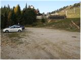
A) From the highway Ljubljana - Jesenice, take the Vodice exit, then continue driving to the first traffic-light intersection in Vodice, where you continue left in the direction of Cerklje na Gorenjskem and Brnik. When you arrive at the main roundabout in Spodnji Brnik, continue driving in the direction of Cerklje and Krvavec ski resort. At the end of the settlement Cerklje na Gorenjskem, leave the main road which continues towards Velesovo and Visoko and continue driving slightly right onto the road in the direction of the Krvavec ski resort. Further on, you arrive at the village Grad, where signs for the settlement Ambrož pod Krvavcem direct you right onto a steep asphalt road (straight ahead: bottom station of the gondola lift to Krvavec and Štefanja Gora). When the gradient on the steep road eases slightly, you will reach an intersection, where you continue left in the direction of the settlement Ambrož pod Krvavcem (straight ahead: settlements Ravne, Apno and Šenturška Gora). A little further, the road temporarily descends slightly, then ascends through occasionally quite scenic slopes. Higher up, you arrive at Ambrož pod Krvavcem, where you bypass the church of St. Ambrož and the tourist farm Pr Ambružarju on the left side. From the tourist farm onwards, the road enters the forest and ascends through it all the way to the mountain pasture Jezerca, where there is a large arranged parking lot. Here the road flattens and turns left, and about 500 m further it brings you to an intersection, where you continue right in the direction of Kriška planina (straight ahead: upper station of the gondola lift and Planinski dom na Gospincu mountain hut). There follows only a short steep ascent and you arrive at the parking lot on the edge of Kriška planina.
Now the road from the mountain pasture Jezerca to Kriška planina is closed to public traffic; this extends the approach by approximately 15 minutes.
B) From the highway Jesenice - Ljubljana, take the Kranj - east exit, then continue driving towards Brnik, Komenda and Mengeš. When you arrive at the main roundabout in Spodnji Brnik, continue driving in the direction of Cerklje and Krvavec ski resort. At the end of the settlement Cerklje na Gorenjskem, leave the main road which continues towards Velesovo and Visoko and continue driving slightly right onto the road in the direction of the Krvavec ski resort. Further on, you arrive at the village Grad, where signs for the settlement Ambrož pod Krvavcem direct you right onto a steep asphalt road (straight ahead: bottom station of the gondola lift to Krvavec and Štefanja Gora). When the gradient on the steep road eases slightly, you will reach an intersection, where you continue left in the direction of the settlement Ambrož pod Krvavcem (straight ahead: settlements Ravne, Apno and Šenturška Gora). A little further, the road temporarily descends slightly, then ascends through occasionally quite scenic slopes. Higher up, you arrive at Ambrož pod Krvavcem, where you bypass the church of St. Ambrož and the tourist farm Pr Ambružarju on the left side. From the tourist farm onwards, the road enters the forest and ascends through it all the way to the mountain pasture Jezerca, where there is a large arranged parking lot. Here the road flattens and turns left, and about 500 m further it brings you to an intersection, where you continue right in the direction of Kriška planina (straight ahead: upper station of the gondola lift and Planinski dom na Gospincu mountain hut). There follows only a short steep ascent and you arrive at the parking lot on the edge of Kriška planina.
Now the road from the mountain pasture Jezerca to Kriška planina is closed to public traffic; this extends the approach by approximately 15 minutes.
Route description:
From the parking lot, head onto the road in the direction of Planina Koren. The road then brings us through the underpass to a quarry, where we leave it. Continue the ascent on a pleasant but otherwise poorly visible mountain path that runs along the edge of the grazing fence. The path, which becomes more visible, then leaves the grazing areas of Kriška planina and enters terrain overgrown with dwarf pines. After a short ascent, the path brings us to a nice vantage point from which a nice view opens onto the Korošica valley. Further on, the path starts to descend more steeply and after a few minutes we are already 60 m lower. The path then levels out and from the right, the path from the previously mentioned valley joins us. Further on, we cross a strip of forest, and the path then starts ascending again. During the ascent, an unmarked path branches off to the left leading to the Razor saddle; we continue on the marked path, which after a further few minutes brings us to the southern part of Planina Koren. The path then descends past the animal watering place to the shepherd's hut on the mountain pasture.
Here our path continues slightly left (slightly right to Planina Košutna) across meadows at the bottom of the valley (the path is initially poorly visible). The path then becomes steeper and after less than 30 minutes of walking brings us to a small puddle, where there is a poorly marked junction. Continue straight ahead (right to Košutna) and follow the gentle path to the next junction, where you continue left in the direction of Vrh Korena (straight ahead to Kompotela). The path ahead starts to ascend more steeply and quickly brings us through karst terrain to the point where we join the path from Veliki Zvoh towards Vrh Korena (Jež ridge). Continue right, and the path brings us in a few steps to the point where the path to Vrh Korena branches off right, which we reach after one more minute of walking.
Kriška planina - Planina Koren 1:15, Planina Koren - Vrh Korena 1:00.

Photos:
 1
1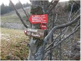 2
2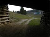 3
3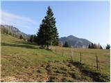 4
4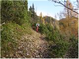 5
5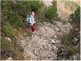 6
6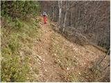 7
7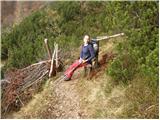 8
8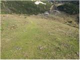 9
9 10
10 11
11 12
12 13
13 14
14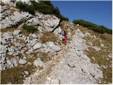 15
15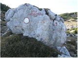 16
16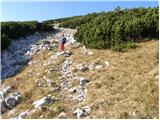 17
17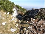 18
18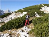 19
19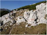 20
20 21
21 22
22 23
23 24
24
Discussion about the trip Kriška planina - Vrh Korena (via Planina Koren)
|
| ROBERT23. 08. 2006 |
one of the most beautiful hikes. suitable for nature admirers. but let me warn you-something special-something very rare in Slovenian mountains-NO ŽIGA!!!
|
|
|
|
| Gost26. 08. 2006 |
robert: stamp collector, missed the summit. Box, book, pencil, stamp. Everything, but some carry ink pads with them to get stamped.
|
|
|
|
| Nickster22. 07. 2008 |
Very nice!
But something bothers me!!!
Just one meter short of 2000!
2000m collectors (me included) would have one more peak.
|
|
|
|
| hajdiga13. 09. 2009 |
Excellent excursion, very beautiful nature and varied path.
|
|
|
|
| vespuci10. 10. 2010 |
Markacists repainted the markers yesterday, thanks on behalf of everyone.
|
|
|
|
| Keki4. 12. 2017 |
Has anyone been to Kompotela and Vrh Korena in the last few days... is the path trodden?
|
|
|
|
| Bandzo4. 12. 2017 |
Yesterday (03.12.2017) my colleague and I headed towards Kompotela. Up to Planina Koren it was trodden and the track fully beaten. From Planina Koren onwards we managed to get a bit past the saddle, where at times we were wading up to our "knees". Beyond the saddle there's a huge amount of wind-blown snow and it collapsed to the waist with every step. Behind us a couple turned back before the saddle, but when we were returning, a freeride skier and his friend with snowshoes followed us, they said they were heading to Košutna. Given their snowshoes and skis, wherever they went further, more treading is needed. From where we turned back, it's probably another 45min of treading to Mokrica. Best, Ben
|
|
|
|
| Keki4. 12. 2017 |
Thanks for the information.
|
|
|
|
| Keki6. 12. 2017 |
Since I'm stubborn, I went to check the conditions anyway. Since there were two fairly nice days in between, I hoped the track would already be well trodden... Well, it's not... up to pl. Koren it's locally blown over, from pl. Koren onwards everything is blown over and crusty snow up to the knees and over, so I turned back a bit below the marker on the rock at the end of the meadow.....Pics on FB.
|
|
|
|
| TinaHefe23. 03. 2019 |
Hello! Does anyone have info if the path is trodden or if there's still a lot of snow? Thanks!
|
|
|
|
| umetnik0077. 06. 2019 |
"Just one meter short of 2000!" If that consoles you - when you're at the top, your head is over 2000
|
|
|
|
| David197724. 10. 2019 |
Today I was on V. Korena and enjoyed the Alps view. I also noticed that the summit book is in disarray, actually a bunch of pages likely ruined by rain.
|
|
|
|
| tjasaam17. 12. 2020 |
Hi! Has anyone been to the summit recently? Is the path trodden? 
|
|
|
|
| Bandzo21. 12. 2020 |
You can get there without issues. Higher up it's still more frozen, lower down it's mushy already in the morning
|
|
|
To post a comment you must log in:
If you do not yet have a username, you must first
register.