Starting point: Gašperjev hrib (1381 m)
| Latitude/Longitude: | 45,591°N 14,4749°E |
| |
Walking time: 1 h 30 min
Difficulty: easy marked way
Elevation gain: 415 m
Elevation difference along the route: 450 m
Map: Snežnik 1:50.000
Recommended equipment (summer):
Recommended equipment (winter): ice axe, crampons
Views: 36.092
 | 2 people like this post |
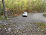
Access to starting point:
A) From Cerknica or Nova vas na Blokah, first we drive to Bloška Polica, from there we continue driving in the direction of Lož and Babno Polje. In the settlement Pudob we turn right in the direction of Snežnik, Ilirska Bistrica, Knežak and nearby settlement Kozarišče. In Kozarišče we continue slightly left in the direction of Snežnik and also in the next crossroads we follow the road in the direction of Snežnik. When Kozarišče ends, the asphalt also ends, and we immediately after the bridge over Mali Obrh continue left in the direction of Mašun and Knežak. There follows a relatively long drive on a macadam road, which we follow approximately 11 km or to Leskova dolina. From Leskova dolina we continue on the main road a little less than 1.5 km or to the spot where signs for Gašperjev hrib 7 km point us left on a somewhat steeper road. After more than 5 km of additional driving we arrive at a marked crossroad, where the inscription on the rock for Gašperjev hrib and Snežnik points us right. We follow this road to a smaller parking lot, by which we notice a mountain signpost for Snežnik.
B) We drive to Pivka, from there we continue driving towards Knežak. In Knežak at the marked crossroad we continue left in the direction of Mašun and settlements Bač and Koritnice. A little further we go right in the direction of Mašun and Koritnice (straight Bač). After Koritnice the road starts to ascend more noticeably, then after 18 km from the main crossroad in Knežak it brings us to Mašun, from where we continue driving right in the direction of Sviščaki. After approximately 2 km of macadam road from Mašun we arrive at a crossroad, where we continue on the left lower road (right road leads towards Sviščaki), on which we drive approximately 4 km, or to the crossroad which is located immediately after the road sign 12 km. At the mentioned crossroad we continue right on the side forest road (straight Kozarišče and Leskova dolina), on which we continue approximately 1.3 km, then we join the road from Leskova dolina. There follows a little less than 4 km of driving, then we arrive at a marked crossroad, where the inscription on the rock for Gašperjev hrib and Snežnik points us right. We follow this road to a smaller parking lot, by which we notice a mountain signpost for Snežnik.
C) First we drive to Ilirska Bistrica, then we continue driving towards Sviščaki (the turn-off is in the middle of Ilirska Bistrica and is marked, perhaps it is a little less noticeable). At first we ascend on an asphalt road, then after a little less than 12 km of ascent the asphalt is replaced by macadam. There follows approximately 7 km of macadam, then we arrive at a crossroad in the immediate vicinity of the mountain hut Planinski dom na Sviščakih, where we continue straight towards the nearby mountain hut on Sviščakih. From the mountain hut we continue driving towards Mašun, where after additional 10 km of macadam we arrive at a crossroad, where we continue sharply right towards Leskova dolina (straight Mašun 2 km). From the crossroad we drive approximately 4 km, or to the crossroad which is located immediately after the road sign 12 km. At the mentioned crossroad we continue right on the side forest road (straight Kozarišče and Leskova dolina), on which we continue approximately 1.3 km, then we join the road from Leskova dolina. There follows a little less than 4 km of driving, then we arrive at a marked crossroad, where the inscription on the rock for Gašperjev hrib and Snežnik points us right. We follow this road to a smaller parking lot, by which we notice a mountain signpost for Snežnik.
Route description:
At the starting point we notice signs for Snežnik, which point us onto a cart track that relatively steeply ascends through the forest. After a few minutes the steepness eases, and the cart track turns into a pleasant footpath that leads us further along and beside an indistinct ridge. The path ahead soon brings us to a vantage point on Snežnik, which then slightly descends and brings us into a belt of dense forest, where it ascends further transversely. Higher up the path brings us to a larger meadow, from which a nice view opens onto the surrounding hills. Further on we continue for some time along the panoramic grassy slope, then the path returns to the forest, where it begins to ascend steeply. From the forest we soon pass among dwarf pines, through which we continue the ascent along an increasingly panoramic slope. There follows a short descent and from the left a less visited path from Grčovca joins us.
We continue in the direction of Snežnik and continue the ascent along the marked path, which brings us from the dwarf pines onto the unvegetated summit slopes of Snežnik. We follow this increasingly panoramic path all the way to the summit, which we reach after a few minutes of further walking.

Photos:
 1
1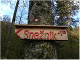 2
2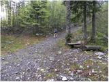 3
3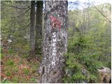 4
4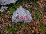 5
5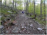 6
6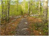 7
7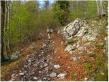 8
8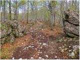 9
9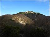 10
10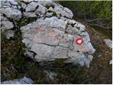 11
11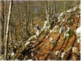 12
12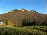 13
13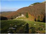 14
14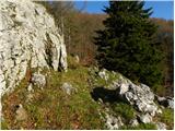 15
15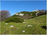 16
16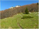 17
17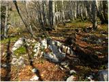 18
18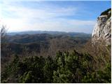 19
19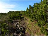 20
20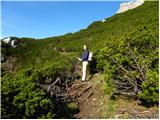 21
21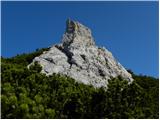 22
22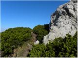 23
23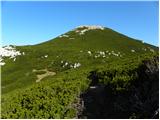 24
24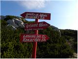 25
25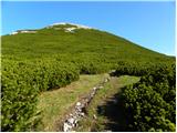 26
26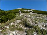 27
27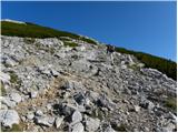 28
28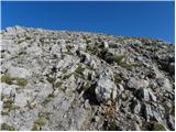 29
29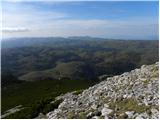 30
30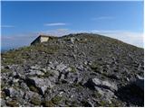 31
31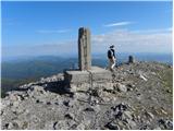 32
32 33
33
Discussion about the trip Gašperjev hrib - Snežnik
|
| vik30. 12. 2011 |
On Wednesday there was a wonderful morning with clear visibility already above Snežnik Castle, while the valleys on the Inner Carniola side remained in fog until the afternoon. Since I managed to drive up high towards Gašperjev hrib early, I decided on a slightly longer hike around Snežnik. First over Gašperjev hrib from the eastern side to the summit, with deep morning views in all directions. No wind, which is rare on Snežnik, all morning. Then down via Mali Snežnik towards Grda Draga, where I turned left uphill into the snow and reached the new (renovated) signpost on the path from Sviščaki, followed it to the summit of Snežnik for the second time. From there I descended south, keeping to the left edge of the scree to the ridge and then down first to the hunting hut, then by road to the car and back to the valley. A full, enjoyable morning in the sun, with beautiful views and sparkling snow, which Snežnik got a fresh layer of yesterday.
|
|
|
|
| šoni13. 03. 2017 |
I'm wondering if this path, in case of very strong bora wind and ice, is also as exposed as the one from Sviščaki, right from the saddle between Snežniks towards the hut, where the bora blows dangerously and it's very dangerous in ice, risk of slipping far.
|
|
|
|
| simon7914. 03. 2017 |
The path is not exposed. In the lower and middle sections it mostly runs through forest, where it is steeply in places (can be dangerous in case of ice, forest partially blocks the bora...), in between it flattens twice or three times across meadows and higher across scrub. The last ascent ca. 20 minutes below the summit is again steep and unsecured - here in winter it could be similar to the saddle between Snežniks, depending on conditions, equipment and hiker's experience.
|
|
|
|
| marco14. 03. 2017 |
Not only is there a high risk of slipping here too, but it's also precipitously close to the saddle.
There is another path, but you have to know it and it's not marked - winter gear is also mandatory.
Good luck!
|
|
|
To post a comment you must log in:
If you do not yet have a username, you must first
register.