Kapelška koča / Eisenkappler Hütte - Hochobir (Ojstrc)
Starting point: Kapelška koča / Eisenkappler Hütte (1553 m)
| Latitude/Longitude: | 46,5019°N 14,5121°E |
| |
Walking time: 1 h 35 min
Difficulty: easy marked way
Elevation gain: 586 m
Elevation difference along the route: 586 m
Map: Karavanke - osrednji del 1:50.000
Recommended equipment (summer):
Recommended equipment (winter): ice axe, crampons
Views: 46.778
 | 1 person like this post |
Access to starting point:
A) From the Ljubljana - Jesenice highway we take the exit Kranj - east and follow the road ahead in the direction of Jezersko. From Zgornje Jezersko we continue driving over the alpine pass Jezerski vrh to Železna Kapla / Bad Eisenkappel, where we turn left in the direction of the settlement Šajda / Zell Schaida. Further, we drive through the valley of the Obirski potok stream, and we follow the road only to the inn Obir Pepi, where we turn right in the direction of the mountain hut Eisenkappler Hütte. The road then starts ascending steeper and brings us higher to Kurnikovo sedlo (997 m), where a road toll is collected. A few more kilometers of driving follow and a quite winding road brings us to a large parking lot at the mountain hut Eisenkappler Hütte.
B) From Štajerska we first drive to Mozirje, then continue driving towards Logarska dolina and later towards Pavličevo sedlo. From Pavličevo sedlo we descend into Bela / Bad Vellach, then continue driving towards Železna Kapla / Bad Eisenkappel, where we turn left in the direction of the settlement Šajda / Zell Schaida. Further, we drive through the valley of the Obirski potok stream, and we follow the road only to the inn Obir Pepi, where we turn right in the direction of the mountain hut Eisenkappler Hütte. The road then starts ascending steeper and brings us higher to Kurnikovo sedlo (997 m), where a road toll is collected. A few more kilometers of driving follow and a quite winding road brings us to a large parking lot at the mountain hut Eisenkappler Hütte.
Route description:
From the parking lot we first walk to the nearby mountain hut, then continue on the marked path in the direction of the summit Ojstrc / Hochobir. The path soon goes above the hut into the forest, through which it then ascends for some time. Higher, the path, along which we notice a larger number of educational-natural history panels, flattens out and brings us out of the forest into the belt of dwarf pines. A few minutes of easy walking follow and the path brings us to benches on the panoramic summit Kraguljše.
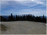
From Kraguljše, from which a nice view of Ojstrc opens up, the path first slightly descends, then brings us past a smaller watering place for animals to a spacious ridge. When we step onto the ridge, the wide marked path turns left and then ascends traversely to the left. After a short ascent we arrive at the saddle "Kalte Quelle", and the path then ascends traversely to the left for some time. Higher, the path turns right and ascends along the edge of a smaller valley to the ruins of the former hut at 2040 m (Rainer Schutzhaus). The path ahead ascends to a smaller saddle in the main ridge of Obirja, where the path from the saddle Šajda / Zell - Schaida joins from the left, and we continue right along and beside the increasingly panoramic ridge, which is mainly dangerous for slipping in snow, to the 2139 m high summit.

Photos:
 1
1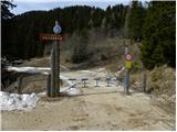 2
2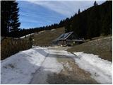 3
3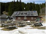 4
4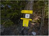 5
5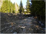 6
6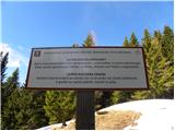 7
7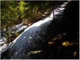 8
8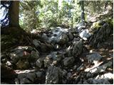 9
9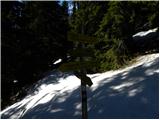 10
10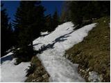 11
11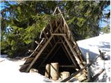 12
12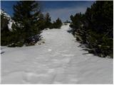 13
13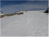 14
14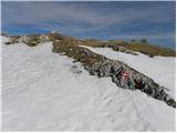 15
15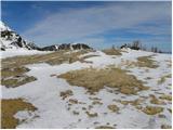 16
16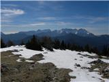 17
17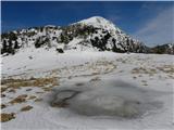 18
18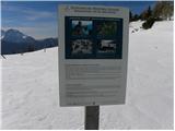 19
19 20
20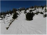 21
21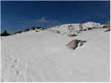 22
22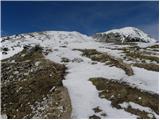 23
23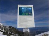 24
24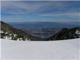 25
25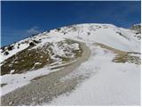 26
26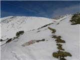 27
27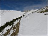 28
28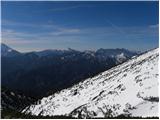 29
29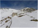 30
30 31
31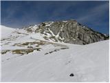 32
32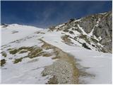 33
33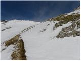 34
34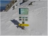 35
35 36
36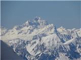 37
37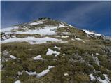 38
38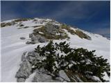 39
39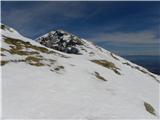 40
40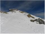 41
41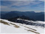 42
42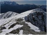 43
43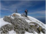 44
44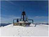 45
45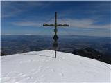 46
46 47
47
Discussion about the trip Kapelška koča / Eisenkappler Hütte - Hochobir (Ojstrc)
|
| matjazvalher9. 06. 2012 |
On the section to the hut they installed an automatic barrier. Toll is 6 euros. Machine accepts only coins.
|
|
|
|
| CarpeDiem24718. 06. 2012 |
Yesterday walked this trail. Interestingly, my buddy and I took quite a few breaks along the way, but we still made it up in an hour and a half. In short, a very nice hike, suitable as an overture to the mountain season. At the end, there was swimming in Lake Klopinjsko. 
|
|
|
|
| wanyola12. 09. 2012 |
On Saturday 8.9. I walked this path with 30 colleagues. The day was wonderful, the path not too strenuous, so even the less "mountaineering" participants managed it. At the top a nice view was offered.
|
|
|
|
| Fulcrum22. 07. 2013 |
Yesterday I climbed to Ojstrc via this path with a small group. The weather was quite foggy, so we couldn't enjoy the view.
The parking meter accepts ONLY COINS.
|
|
|
|
| michael6613. 08. 2013 |
What is the road to the hut like, is there any asphalt??
|
|
|
|
| cawt13. 08. 2013 |
Was there last week. Went from the barrier. To the parking lot before the hut is asphalt, 8 km. Great tour suitable for all generations.
|
|
|
|
| cawt13. 08. 2013 |
And here the full description of the hiked path: http://www.lidija.info/?p=131
|
|
|
|
| lepenatka2. 08. 2014 |
Maybe one useful info, at least for those who don't always carry change with them.
The toll ramp is 1 km lower than the old one with the shortcut, which is no longer valid.
Price is 6 eur in coins from 10 cents upwards.
If you don't have it, back to the valley for change - like me today, and probably I wasn't the only one.
Parking space near the ramp is also very limited.
|
|
|
|
| pemi28. 09. 2014 |
Excellent tour, suitable also for families with children, one correction: Ojstrc is 2142 m above sea level 
|
|
|
|
| obir8. 05. 2018 |
Road open. Hut closed. Path to the summit mostly dry, with some snow patches on the gentle sections.
|
|
|
|
| seinfeld15. 08. 2018 |
We did this path on Monday. Really easy path, nicely laid out, nowhere steep. Phenomenal views, especially on Kamniško-Savinjske and Karavanke, and on Rož and Podjuno.
Access road long, asphalted. Model for our torn-up gravel mountain roads. I'd rather pay 6eur than listen to rattling from the chassis.
|
|
|
|
| Frisvape5. 08. 2023 08:58:33 |
Was there on 29.7. Now 8€ toll for the road, otherwise nice tour, beautiful views, recommend going early in the morning because then it's quite crowded.
|
|
|
|
| Lesicnik21. 09. 2023 14:38:54 |
I can confirm what Frisvape wrote.
Super road up, 8€ toll to be paid in coins, but now there's a change machine next to it (haven't tried it yet).
Definitely better to be up before 10/11, as crowds usually start after that.
Great views, fairly easy tour, definitely worth the hike.
|
|
|
|
| Ales6211. 08. 2024 21:01:14 |
Today visited Ojstrc. Toll still 8 EUR. Payment at the roadside machine with coins, bill-to-coin machine next to the payment machine. In my assessment the road up to the ramp with the payment machine is OK. Then to the next ramp which is always up, the road narrows and is in noticeably worse condition, asphalted but full of patches and in my view very poor condition for Austrian standards, I'd say disastrous, extremely narrow without safety barriers. Frankly since the road is tolled it should be in much better condition, haven't experienced such a bad road in Austria, e.g. road to Dobrač toll 20 EUR but road excellent, plenty of rest spots with benches, huge parking, extremely nice new building with toilets right after the parking, no comparison with Ojstrc.
Oncoming traffic is dangerous or impossible in some places, requires full attention. We were lucky to meet only two cars at once going up and passing wasn't exactly easy or pleasant, for inexperienced drivers maybe critical. Parking large enough, few vehicles around 9 o'clock. To the summit from hut approx. 1:40 with one approx. 10-minute break, path safe but first half to treeline exit quite steep, then gentler without dangerous sections, suitable for families observing basic mountain safety rules. Proper footwear required, recommend poles. View from summit wonderful, especially Drava valley, Klagenfurt, Wörthersee and Keutschacher See, quite a few Slovenians at top, descent approx. 1:10. At the hut rather unfriendly, food nothing special, I'd say below average. Large draft beer 4.90 EUR, soup 6.90 EUR, hot meals 15.90-19.90 EUR, after 1 pm quite crowded at hut.
|
|
|
|
| jprim12. 08. 2024 10:29:47 |
You really elaborated.
Was at Obir some time ago, of course not as comfortably as described, just takes a bit more time, Šajda saddle - Obir summit - hut - Šajda saddle. Yes, lots of distance and elevation.
You comment the road, don't know it since I never drove to the hut.
What about the path and hut themselves?
Few years ago everything super, now unmaintained path - especially above the hut and the hut looks more neglected too. Really could say, for Austria some minuses.
LP!
|
|
|
|
| turbo12. 08. 2024 10:36:16 |
If this road is narrow and dangerous then better start on foot right from the valley  As for the hut, oh well super and friendly As for the hut, oh well super and friendly  Some 25 years ago when we did quite some ski touring there and the hut was already open on spring weekends Some 25 years ago when we did quite some ski touring there and the hut was already open on spring weekends
|
|
|
|
| nejcf25. 08. 2024 20:14:09 |
No, the road is by no means as bad as Aleš wrote. Meeting cars is mostly not problematic, and the slope is not that terribly steep either. I agree that the asphalt quality is very subpar given the 8 EUR toll. Today the machine for changing bills to coins was not working, which caused bad mood among many visitors.
|
|
|
|
| DVas27. 08. 2024 08:31:23 |
Ravenska Kočna costs 10 Eur, and we have to drive on gravel. Something similar at Valvasor too, if I'm not mistaken.
|
|
|
|
| keti121. 05. 2025 13:16:41 |
And does anyone know if the road is open yet? Is it still 8 euros and payment with coins? Any snow on the path?
Thanks for the information.
|
|
|
|
| samuel21. 05. 2025 16:01:40 |
Hello,
status on May 1st: road is open, don't know about the price (came by bike), some snow towards the top, but no problem with cycling shoes and shorts .
click
|
|
|
|
| piotr24. 05. 2025 20:05:43 |
Toll for Obirska cesta is 10€ this year, specifically in coins!
|
|
|
|
| keti110. 10. 2025 11:07:21 |
Does anyone know about the road accessibility and the conditions on the trail (snow?, winter gear needed?)?
|
|
|
To post a comment you must log in:
If you do not yet have a username, you must first
register.