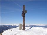
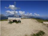
 | Dom na Gospincu - Veliki Zvoh
Veliki Zvoh is the highest point of the Krvavec ski resort. The cable car does not quite reach the summit but stops only a few metres short. A fe...
1 h 25 min |
| Kriška planina - Veliki Zvoh
Veliki Zvoh is the highest point of the Krvavec ski resort. The cable car does not quite reach the summit but stops only a few metres short. A fe...
1 h 25 min |
 | Planina Jezerca - Veliki Zvoh (via Dom na Krvavcu)
Veliki Zvoh is the highest point of the Krvavec ski resort. The cable car does not quite reach the summit but stops only a few metres short. A fe...
1 h 40 min |
 | Rudno polje - Viševnik
Viševnik is a 2050 m high mountain rising northwest of Rudno polje on Pokljuka. From the summit, where there is a stamp, a beautiful view opens o...
2 h |
 | Pri Rupah - Mrežce (direct way)
Mrežce is a panoramic peak near Lipanski vrh, which is visible on the other side of the gully between the two peaks. Since the slopes towards Pok...
1 h 40 min |
 | Planina Zajavornik - Mrežce
Mrežce is a panoramic peak near Lipanski vrh, which is visible on the other side of the gully between the two peaks. Since the slopes towards Pok...
1 h 55 min |
 | Planina Zajavornik - Mrežce (gentle path)
Mrežce is a panoramic peak near Lipanski vrh, which is visible on the other side of the gully between the two peaks. Since the slopes towards Pok...
2 h |
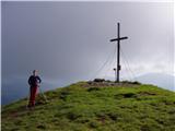
 | Pri Rupah - Lipanski vrh
The panoramic Lipanski vrh is located above the Blejska koča on the Lipanca mountain pasture. From the summit, which drops steeply towards the Kr...
1 h 45 min |
 | Dom pod Storžičem - Tolsti vrh
Tolsti vrh, located west of Storžič, is at 1715 metres also the highest peak of the Kriška gora range, which rises steeply above central Gorenjsk...
2 h |
 | Sviščaki - Snežnik (footpath)
Snežnik, or Veliki Snežnik, at 1796 metres is the highest peak in the near and far surroundings, offering a beautiful view over a large part of S...
2 h |
| Snežniška Grda jama - Snežnik (via Mali Snežnik)
Snežnik, or Veliki Snežnik, at 1796 metres is the highest peak in the near and far surroundings, offering a beautiful view over a large part of S...
1 h 25 min |
 | Gašperjev hrib - Snežnik
Snežnik, or Veliki Snežnik, at 1796 metres is the highest peak in the near and far surroundings, offering a beautiful view over a large part of S...
1 h 30 min |
 | Gašperjev hrib - Snežnik
Snežnik, or Veliki Snežnik, at 1796 metres is the highest peak in the near and far surroundings, offering a beautiful view over a large part of S...
1 h 30 min |
 | Sviščaki - Snežnik (variant through forest)
Snežnik, or Veliki Snežnik, at 1796 metres is the highest peak in the near and far surroundings, offering a beautiful view over a large part of S...
2 h |
| Sežanje - Snežnik
Snežnik, or Veliki Snežnik, at 1796 metres is the highest peak in the near and far surroundings, offering a beautiful view over a large part of S...
1 h 40 min |
 | Sviščaki - Snežnik (by road)
Snežnik, or Veliki Snežnik, at 1796 metres is the highest peak in the near and far surroundings, offering a beautiful view over a large part of S...
1 h 55 min |
| Grda draga - Snežnik (via Mali Snežnik)
Snežnik, or Veliki Snežnik, at 1796 metres is the highest peak in the near and far surroundings, offering a beautiful view over a large part of S...
1 h 55 min |
 | Planina Loka - Velika Raduha
Velika Raduha, at 2062 m, is the highest peak of the Raduha range, which rises steeply east of Robanov Kot. From the summit, with its registratio...
1 h 55 min |
 | Snežna jama - Velika Raduha
Velika Raduha, at 2062 m, is the highest peak of the Raduha range, which rises steeply east of Robanov Kot. From the summit, with its registratio...
1 h 45 min |
 | Križovec - Kahlkogel/Golica (via mountain hut)
Golica is a treeless peak located north of Jesenice. The summit features a registration box and offers a beautiful view of the western Karawanks ...
2 h |
 | end of road on Vogar - Pršivec (direct way)
Pršivec is a panoramic mountain above Lake Bohinj. The view is extensive in all directions: Triglav and the surrounding mountains are clearly vis...
1 h 30 min |
 | Medvedova konta - Brda (west path)
Brda is a panoramic peak situated between Pokljuka and Krma. The summit has a stamp attached to a metal pole and offers a beautiful view towards ...
2 h |
| Medvedova konta - Brda (east path)
Brda is a panoramic peak situated between Pokljuka and Krma. The summit has a stamp attached to a metal pole and offers a beautiful view towards ...
2 h |
 | Pri Rupah - Brda (west path)
Brda is a panoramic peak situated between Pokljuka and Krma. The summit has a stamp attached to a metal pole and offers a beautiful view towards ...
2 h |
 | Pri Rupah - Brda (east path)
Brda is a panoramic peak situated between Pokljuka and Krma. The summit has a stamp attached to a metal pole and offers a beautiful view towards ...
2 h |
 | Ravne - Frauenkogel/Dovška Baba (footpath)
Dovška Baba is a 1891-meter-high peak located on the border ridge between Slovenia and Austria. From the summit, which has a registration box and...
1 h 45 min |
| Ravne - Frauenkogel/Dovška Baba (by road)
Dovška Baba is a 1891-meter-high peak located on the border ridge between Slovenia and Austria. From the summit, which has a registration box and...
1 h 50 min |
 | Planina Dol - Konj
Konj is an 1803 m high peak located between Velika Planina and Presedljaj. From the summit there is a beautiful view of the highest peaks of the ...
1 h 30 min |
 | Ravne - Rosenkogel/Hruški vrh (direct way)
Hruški vrh is a 1776-metre-high mountain located between Dovška Baba and the lesser-known Klek. From the summit, where there is a small chapel de...
2 h |
 | Ski hotel Vogel - Šija
Šija is located above the Vogel ski resort in the Lower Bohinj Mountains. From the summit, there is a nice view of the neighboring peaks in the s...
1 h 30 min |
 | Planina Zapleč - Krasji vrh (via Koluji)
Krasji vrh is situated between Bovec and Kobarid on the Polovnik mountain ridge. At 1773 m it is also the highest peak of the mentioned ridge, so...
2 h |
| Planina Zapleč - Krasji vrh (via snežna jama)
Krasji vrh is situated between Bovec and Kobarid on the Polovnik mountain ridge. At 1773 m it is also the highest peak of the mentioned ridge, so...
2 h |
 | Winterleiten parking - Scharfes Eck
Scharfes Eck is a peak on which stands an Austrian meteorological radar station. From the summit, there is a beautiful view of the neighbouring p...
2 h |
 | Walischeben - Weißenstein (Packalpe) (Direct way)
Weißenstein is a grassy mountain crisscrossed with wire fences. From its indistinct summit, there is a nice view of the neighboring Ameringkogel ...
1 h 45 min |
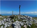
 | Walischeben - Ameringkogel (Packalpe) (Direct way)
Ameringkogel is a grassy summit with a cross and summit register. At 2,187 meters, it is the highest peak of the Packalpe. In good visibility, th...
1 h 55 min |
 | Salzstiegelhaus - Hofalmkogel (Packalpe)
Hofalmkogel is a less distinct peak in the ridge from Großenberg to Speikkogel. The summit is broad and mostly grassy. From the top, there is a b...
1 h 50 min |
 | Walischeben - Speikkogel (Packalpe)
Speikkogel is a spacious and grassy summit in the Packalpe mountain group. From the top, there is a beautiful view towards the Slovenian mountain...
2 h |
 | Salzstiegelhaus - Speikkogel (Packalpe)
Speikkogel is a spacious and grassy summit in the Packalpe mountain group. From the top, there is a beautiful view towards the Slovenian mountain...
1 h 15 min |
 | Zadnji travnik - Govca (Olševa)
Govca is the highest peak of the Olševa range, rising above Koprivna, Solčava, and Remšenik (Remšenik/Remschenig is a valley on the Austrian side...
1 h 45 min |
 | Jezerski vrh - Kärntner Storschitz / Pristovški Storžič
Pristovški Storžič (Kärntner Storschitz) is an exceptionally panoramic peak above Jezersko. From it, there are fine views of the northern walls o...
1 h 50 min |
 | Plattner - Gartnerkofel (via Watschiger Alm)
Gartnerkofel is a 2,195-meter-high mountain in the Nassfeld ski area. Its Slovenian name is Krniške skale. From the summit, where a cross stands,...
2 h |
| Plattner - Gartnerkofel (direct way)
Gartnerkofel is a 2,195-meter-high mountain in the Nassfeld ski area. Its Slovenian name is Krniške skale. From the summit, where a cross stands,...
1 h 15 min |
 | Dolinza Alm/Planina Dolnica - Starhand
Starhand is a panoramic peak in the eastern part of the Carnic Alps near the better-known Ojstrnik. From the top, there are beautiful views of th...
1 h 40 min |
 | Rosstratte - Dobratsch / Dobrač (by road)
Dobrač, or in German Dobratsch and also known as Villacher Alpen, is a 2166-meter-high mountain situated on the far eastern edge of the Gailtal A...
1 h 20 min |
 | Rosstratte - Dobratsch / Dobrač (by road)
Dobrač, or in German Dobratsch and also known as Villacher Alpen, is a 2166-meter-high mountain situated on the far eastern edge of the Gailtal A...
2 h |
 | Waldrast - Großer Speikkogel (Koralpe)
Großer Speikkogel is, at 2,140 meters, the highest peak of Golica/Koralpe, a range east of Volšperk/Wolfsberg. From the summit, where a cross and...
2 h |
 | Turracher Höhe - Rinsennock (northern way)
Rinsennock is a 2,334 m high peak located in the heart of the Gurktal Alps. From the summit, where a cross stands, there are fine views ranging f...
1 h 45 min |
| Turracher Höhe - Rinsennock (southern way)
Rinsennock is a 2,334 m high peak located in the heart of the Gurktal Alps. From the summit, where a cross stands, there are fine views ranging f...
1 h 45 min |
 | Turracher Höhe - Schoberriegel
Schoberriegel is a 2,208 m high peak located between the Turracher Höhe alpine pass and the slightly higher Gruft. From the summit, where a cross...
1 h 20 min |
 | Turracher Höhe - Gruft
Gruft is a grass-covered peak located southeast of the Turracher Höhe pass in the heart of the Gurktal Alps. From its 2,232 m high summit there a...
1 h 45 min |
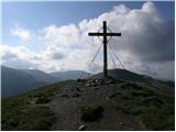
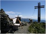
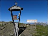
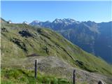
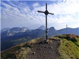
 | Planina Jezerca - Krvavec
Krvavec is a 1,853-meter-high peak located in the heart of the eponymous ski resort. From the summit, which is crisscrossed with cable cars, ther...
1 h 10 min |
 | Pri Rupah - Okroglež
Okroglež is a peak covered with dwarf pines, located between Debela peč and Brda. From the summit, which has a stamp (no logbook), a nice view op...
1 h 55 min |
 | Planina Loka - Lanež (eastern way)
Lanež is a less distinct peak on the eastern part of Raduha. From the spacious summit a nice view opens on nearby Mala Raduha, Olševa, Peca, Uršl...
1 h 25 min |
| Planina Loka - Lanež (via Durce)
Lanež is a less distinct peak on the eastern part of Raduha. From the spacious summit a nice view opens on nearby Mala Raduha, Olševa, Peca, Uršl...
1 h 25 min |
 | Panoramarestaurant Oben - Feistritzer Spitze (past old cotage)
Bistriška špica is a 2113 m high peak located on the Austrian side of Peca. From the summit, which features a cross, there is a fine view of the ...
2 h |
 | Panoramarestaurant Oben - Končnikov vrh (Peca)
Končnikov vrh (German: Knieps) is a 2109 m high peak situated in the central part of Peca. From the grassy summit, there is a beautiful view of t...
1 h 20 min |
 | Panoramarestaurant Oben - Končnikov vrh (Peca) (past old cotage)
Končnikov vrh (German: Knieps) is a 2109 m high peak situated in the central part of Peca. From the grassy summit, there is a beautiful view of t...
1 h 15 min |
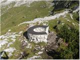 | Rifugio Selvapiana I.Lunelli - Belvedere (Creston Popera)
Belvedere is a 2,125-meter peak on the slopes of the Creston Popera ridge, a known battlefield from World War I. The summit features a stone semi...
1 h 40 min |
 | Heidi Alm - Schwarzkofel (ridge path)
Schwarzkofel is a 2168 m high peak located south of the Heidialm pasture. From the summit, where a small cross stands, a fine panorama opens up o...
2 h |
 | Heidi Alm - Rodresnock (ridge path)
Rodresnock is a 2310 m high mountain rising southwest of Lake Falkertsee. From the summit, where a large cairn stands with a cross in its center,...
1 h 30 min |
 | Heidi Alm - Rodresnock (via Falkertscharte)
Rodresnock is a 2310 m high mountain rising southwest of Lake Falkertsee. From the summit, where a large cairn stands with a cross in its center,...
1 h 30 min |
 | Heidi Alm - Falkert (via Falkertscharte)
Falkert is a 2308 m high peak located west of the village and Lake Falkertsee. From the summit, which has a few benches, a summit logbox with sta...
1 h 30 min |
 | Heidi Alm - Falkert (direct way)
Falkert is a 2308 m high peak located west of the village and Lake Falkertsee. From the summit, which has a few benches, a summit logbox with sta...
1 h 15 min |
 | Heidi Alm - Falkert (via Hundsfeldscharte)
Falkert is a 2308 m high peak located west of the village and Lake Falkertsee. From the summit, which has a few benches, a summit logbox with sta...
1 h 30 min |
 | parking below Weinebene - Hühnerstütze (Golica/Koralpe) (panoramic path)
Hühnerstütze is a 1989 m high peak in the Golica / Koralpe range. From the indistinct, mostly grassy summit, nice views open up on Großer Speikko...
2 h |
 | Gasthof Pfeifferstocker - Weberkogel
Weberkogel is a less prominent peak located north to northwest of the alpine pass Weinebene. On the 1805-meter-high summit stands a medium-sized ...
1 h 50 min |
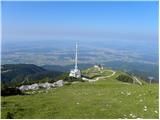
 | Zettersfeld - Goiselemandl
Goiselemandl is a 2,433-meter-high peak in the Schober mountain group. The mountain is fairly well-visited due to its proximity to the cable car....
1 h 30 min |
 | Obertauern - Gamsleitenspitze
Gamsleitenspitze is a 2359-meter-high mountain in the Radstädter Tauern mountain group. From the summit, located above the Obertauern ski center,...
2 h |
 | Iličev rovt / Illitsch Rauth - Kamnica (Komnica) / Ferlacher Spitze
Kamnica is a panoramic mountain on the Austrian side of the Karawanks, more precisely north of Kepa. From the summit, which has a cross, summit r...
1 h 35 min |
 | Rifugio Fedare - Monte Pore
Monte Pore or Spiz de Poure is a 2,405-meter-high grassy peak located west of the Averau and Nuvolau summits. From the top, where a large cross s...
1 h 30 min |
 | Passo Campolongo - Stores
Stores is a 2,185-meter-high peak on the southeastern part of the Pralongia plateau. From the grassy summit where a cross stands, there is a very...
2 h |
 | Wiesser Alm - Mirnock (Path 184)
Mirnock is a 2,110 m high isolated and highly panoramic mountain massif in Carinthia. It is part of the Nockberge group in the Gurktal Alps, loca...
1 h 30 min |
 | Mavros Charakas - Pachnes (Crete)
Pahnes, at 2,453 meters, is the highest mountain in the Lefka Ori range ("White Mountains") on Crete in Greece (Pahnes is Πάχνες in Greek, Lefka ...
1 h 20 min |
 | Salzstiegelhaus - Peterer Riegel
Peterer Riegel is a panoramic peak above the Peterer Sattel saddle. From the summit, where a cross stands and a bench sits below it, a beautiful ...
1 h 45 min |
 | Nassfeld - Garnitzenberg / Monte Carnizza (via Auernig Alm)
Krniška gora (Italian Monte Carnizza, German Garnitzenberg) is a 1950-meter-high mountain east of the Mokrine mountain pass. It is located on the...
1 h 50 min |
| Nassfeld - Garnitzenberg / Monte Carnizza (Auernig Höhenweg)
Krniška gora (Italian Monte Carnizza, German Garnitzenberg) is a 1950-meter-high mountain east of the Mokrine mountain pass. It is located on the...
2 h |
 | Kohlebnerstand - Windberg (northern path)
Windberg is a 1903-meter-high peak in the Schneealpe mountain group and, with its elevation, the highest peak of the group. From the summit, wher...
1 h 50 min |
| Kohlebnerstand - Windberg (southern path)
Windberg is a 1903-meter-high peak in the Schneealpe mountain group and, with its elevation, the highest peak of the group. From the summit, wher...
1 h 50 min |
 | Kohlebnerstand - Hoher Klapf
Hoher Klapf is a panoramic pathless peak in the Schneealpe mountain group, located near the group's highest peak, Windberg....
1 h 40 min |
 | Panoramarestaurant Oben - Križnik (Peca)
Križnik is a 2,109-meter-high peak on Peca, located on the Austrian side of the mountain. From the summit, just a short way above the marked path...
1 h 40 min |
 | Seebergsattel - Seeleiten
Seeleiten is a panoramic peak with a cross on the Aflenzer Staritzen ridge, which belongs to the Hochschwab mountain group....
1 h 30 min |