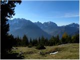
 | Markova raven - Veliki Zvoh (on unmarked path via Razor)
Veliki Zvoh is the highest point of the Krvavec ski resort. The cable car does not quite reach the summit but stops only a few metres short. A fe...
3 h |
 | Uskovnica (Razpotje) - Viševnik (via source of Zlata voda)
Viševnik is a 2050 m high mountain rising northwest of Rudno polje on Pokljuka. From the summit, where there is a stamp, a beautiful view opens o...
2 h 55 min |
 | Uskovnica (Razpotje) - Viševnik (via Gola Ravan)
Viševnik is a 2050 m high mountain rising northwest of Rudno polje on Pokljuka. From the summit, where there is a stamp, a beautiful view opens o...
2 h 50 min |
 | Ljubelj - Vrh Ljubeljščice (Triangel)
Above the Zelenica ski area more precisely above the Triangel ski lift lies a 1704 m high peak that is the highest point of the Ljubeljščica ri...
1 h 50 min |
 | Gozd - Tolsti vrh (Ovčja pot over Kriška gora)
Tolsti vrh, located west of Storžič, is at 1715 metres also the highest peak of the Kriška gora range, which rises steeply above central Gorenjsk...
2 h 30 min |
 | Tominčev slap Waterfall - Dobrča
Dobrča is a 1634-metre mountain located between Begunje and Tržič. From the summit, which has a registration box with a stamp, the view opens onl...
3 h |
 | Grahovše - Veliki Javornik (Ženiklovec)
Veliki Javornik (also known as Ženiklovec) is a 1716 m high peak located between Storžič and Stegovnik. From the grassy summit with its registrat...
2 h 45 min |
 | Dom pod Storžičem - Veliki Javornik (Ženiklovec)
Veliki Javornik (also known as Ženiklovec) is a 1716 m high peak located between Storžič and Stegovnik. From the grassy summit with its registrat...
1 h 50 min |
| Tržiški graben - Veliki Javornik (Ženiklovec)
Veliki Javornik (also known as Ženiklovec) is a 1716 m high peak located between Storžič and Stegovnik. From the grassy summit with its registrat...
2 h 30 min |
| Grahovše - Veliki Javornik (Ženiklovec) (via Rekar)
Veliki Javornik (also known as Ženiklovec) is a 1716 m high peak located between Storžič and Stegovnik. From the grassy summit with its registrat...
2 h 45 min |
 | Leskovica - Blegoš (on unmarked path)
Blegoš is a 1,562-metre-high mountain located between the Selška Sora and Poljanska Sora rivers. From the grassy summit, where there is a stamp a...
2 h 5 min |
 | Križovec - Barentaler Kotschna/Struška (footpath)
Struška is a smaller mountain range located between Stol (or Belščica) and Golica. From its highest peak, Veliki vrh, there is a beautiful view o...
2 h 30 min |
| Križovec - Barentaler Kotschna/Struška (by road)
Struška is a smaller mountain range located between Stol (or Belščica) and Golica. From its highest peak, Veliki vrh, there is a beautiful view o...
2 h 15 min |
 | Planina pod Golico - Barentaler Kotschna/Struška
Struška is a smaller mountain range located between Stol (or Belščica) and Golica. From its highest peak, Veliki vrh, there is a beautiful view o...
3 h |
 | Dom Pristava in Javorniški Rovt - Barentaler Kotschna/Struška (via Dobravske rovte)
Struška is a smaller mountain range located between Stol (or Belščica) and Golica. From its highest peak, Veliki vrh, there is a beautiful view o...
2 h 30 min |
| Dom Pristava in Javorniški Rovt - Barentaler Kotschna/Struška (by road)
Struška is a smaller mountain range located between Stol (or Belščica) and Golica. From its highest peak, Veliki vrh, there is a beautiful view o...
3 h |
 | Planina pod Golico - Kahlkogel/Golica (via Ovčarska koča - eastern way)
Golica is a treeless peak located north of Jesenice. The summit features a registration box and offers a beautiful view of the western Karawanks ...
2 h 45 min |
 | Križovec - Kahlkogel/Golica (on ridge)
Golica is a treeless peak located north of Jesenice. The summit features a registration box and offers a beautiful view of the western Karawanks ...
2 h |
| Dom Pristava in Javorniški Rovt - Kahlkogel/Golica (on ridge)
Golica is a treeless peak located north of Jesenice. The summit features a registration box and offers a beautiful view of the western Karawanks ...
2 h 45 min |
 | Erjavčev rovt - Frauenkogel/Dovška Baba (direct way)
Dovška Baba is a 1891-meter-high peak located on the border ridge between Slovenia and Austria. From the summit, which has a registration box and...
2 h 15 min |
 | Rogarjev rovt - Frauenkogel/Dovška Baba (via Rožca and Hruški vrh)
Dovška Baba is a 1891-meter-high peak located on the border ridge between Slovenia and Austria. From the summit, which has a registration box and...
2 h 30 min |
 | Tinčkova koča - Srednji vrh (above Završnica) (via Zagon)
Srednji vrh is a panoramic mountain covered in dwarf pine, located between Stol, Vrtača and Begunjščica. From the summit, which drops steeply to ...
2 h |
 | Smrečje - Pečovnik (survey point 1668) (by road)
Pečovnik (1668 m) is a 1668-meter-high mountain located between Plešivec (1801 m) and Virnikov Grintovec (1654 m). From its grassy summit on the ...
2 h 45 min |
 | Jezerski vrh - Pečovnik (survey point 1668)
Pečovnik (1668 m) is a 1668-meter-high mountain located between Plešivec (1801 m) and Virnikov Grintovec (1654 m). From its grassy summit on the ...
2 h 45 min |
 | Rateče - Ofen/Peč (western path, past bivouac and on footpath)
Peč (also known as Tromeja; in Italian Monte Forno, in German Dreiländereck or Ofen) is a 1508 m high peak located at the tripoint between Sloven...
2 h 15 min |
| Rateče - Ofen/Peč (western path, past bivouac and on mule track)
Peč (also known as Tromeja; in Italian Monte Forno, in German Dreiländereck or Ofen) is a 1508 m high peak located at the tripoint between Sloven...
2 h 20 min |
 | Polja - Ofen/Peč (via Petelinjek)
Peč (also known as Tromeja; in Italian Monte Forno, in German Dreiländereck or Ofen) is a 1508 m high peak located at the tripoint between Sloven...
2 h 45 min |
| Polja - Ofen/Peč (via Kališje)
Peč (also known as Tromeja; in Italian Monte Forno, in German Dreiländereck or Ofen) is a 1508 m high peak located at the tripoint between Sloven...
2 h 15 min |
 | Javorje - Rodica (via Lepa Suha)
The mountain Rodica is located above Bohinj in the Lower Bohinj Mountains. From the summit there is a beautiful view over the Julian Alps and the...
2 h 30 min |
 | Planina Blato - Ogradi
Ogradi is located between the Laz and Krstenica mountain pastures. The summit is grassy with plenty of space. A small cross stands on the top. Fr...
2 h 45 min |
 | Dom Pristava in Javorniški Rovt - Ptičji vrh
Ptičji vrh is a 1550-metre-high mountain located between Struška and Golica. From the summit, which lies on the border between Slovenia and Austr...
1 h 45 min |
 | Dol - Bukovec
The mountain Bukovec is located between Kozji vrh, Stegovnik, and Virnikov Grintovec. The summit partially emerges from the forest, offering a be...
1 h 40 min |
 | Ravne - Rosenkogel/Hruški vrh (via Dovška Baba)
Hruški vrh is a 1776-metre-high mountain located between Dovška Baba and the lesser-known Klek. From the summit, where there is a small chapel de...
2 h 25 min |
 | Martinčev Rovt - Rosenkogel/Hruški vrh
Hruški vrh is a 1776-metre-high mountain located between Dovška Baba and the lesser-known Klek. From the summit, where there is a small chapel de...
1 h 45 min |
 | Rogarjev rovt - Rosenkogel/Hruški vrh (via Rožca)
Hruški vrh is a 1776-metre-high mountain located between Dovška Baba and the lesser-known Klek. From the summit, where there is a small chapel de...
1 h 40 min |
 | Ravne - Klek (via Hruški vrh)
Klek is a 1753-metre-high mountain located between Hruški vrh and the better-known Golica. The summit, on the border between Slovenia and Austria...
2 h 30 min |
| Planina pod Golico - Klek (via Rožca)
Klek is a 1753-metre-high mountain located between Hruški vrh and the better-known Golica. The summit, on the border between Slovenia and Austria...
2 h 20 min |
 | Planina pod Golico - Klek (via Ovčarska koča)
Klek is a 1753-metre-high mountain located between Hruški vrh and the better-known Golica. The summit, on the border between Slovenia and Austria...
3 h |
 | Log - Vošca
Vošca is a 1737 m high peak located west of Trupejevo poldne. From the grassy summit, there is a beautiful view of the Julian Alps, western Karaw...
2 h 30 min |
| Srednji vrh - Vošca
Vošca is a 1737 m high peak located west of Trupejevo poldne. From the grassy summit, there is a beautiful view of the Julian Alps, western Karaw...
2 h |
 | Srednji Vrh - Vošca (via Zajčnik)
Vošca is a 1737 m high peak located west of Trupejevo poldne. From the grassy summit, there is a beautiful view of the Julian Alps, western Karaw...
2 h 35 min |
| Srednji Vrh - Vošca (via Jureževa planina)
Vošca is a 1737 m high peak located west of Trupejevo poldne. From the grassy summit, there is a beautiful view of the Julian Alps, western Karaw...
2 h 5 min |
 | Srnjak - Vošca
Vošca is a 1737 m high peak located west of Trupejevo poldne. From the grassy summit, there is a beautiful view of the Julian Alps, western Karaw...
2 h 45 min |
 | Srednji vrh - Techantinger Mittagskogel (Trupejevo poldne) (via Železnica)
The mountain is located on the border with Austria above Gozd Martuljek. From the bare summit, there is a beautiful view of the Julian Alps and t...
2 h 30 min |
 | Srednji Vrh - Techantinger Mittagskogel (Trupejevo poldne) (via valley of stream Žlebnica)
The mountain is located on the border with Austria above Gozd Martuljek. From the bare summit, there is a beautiful view of the Julian Alps and t...
2 h 45 min |
 | Srednji Vrh - Kresišče (via Grajšca)
Kresišče is an 1839 m high peak in the main ridge of the Karawanks, specifically between Kepa and Trupejevo poldne. From the summit, where a wood...
2 h 50 min |
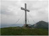
 | Urbas - Weinasch/Vajnež
Vajnež is the highest peak of Belščica, a subrange located west of the better-known Stol. The summit features a cross and both Slovenian and Aust...
2 h 25 min |
 | Okrog pri Motniku - Vivodnik (via Biba planina)
Vivodnik, at 1508 meters, is the highest peak of Menina planina, a plateau rising south of Gornji Grad. From the summit, which has a small observ...
2 h 25 min |
| Okrog pri Motniku - Vivodnik (via Oseke and peak Drč)
Vivodnik, at 1508 meters, is the highest peak of Menina planina, a plateau rising south of Gornji Grad. From the summit, which has a small observ...
2 h 15 min |
 | Javorje - Šija (via Kratki plaz)
Šija is located above the Vogel ski resort in the Lower Bohinj Mountains. From the summit, there is a nice view of the neighboring peaks in the s...
2 h 40 min |
 | Urbas - Potoški Stol
Potoški Stol is located between Stol and Vajnež on the border with Austria. A cross stands just a few metres below the grassy summit. The finest ...
2 h 15 min |
 | Valley of stream Žep - Komen
At 1684 meters, Komen is the highest peak in the Smrekovec mountain range, which borders between Styria and Carinthia. In good weather, the summi...
2 h 30 min |
 | Valley of stream Žep - Veliki Travnik (Turnovka) (via partisan hospital)
Veliki Travnik, also known as Turnovka by the locals, is located on the western edge of the Smrekovec mountain range. From the summit, which has ...
2 h 25 min |
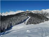
 | Mislinjski graben (Pestotnik) - Rogla (via Ostruščica)
Rogla is a peak in the middle of the eponymous ski resort. The peak is forested with a small clearing on which stands a lookout tower. The tower ...
3 h |
 | Smrečje - Pečovnik (by road)
Pečovnik is a 1640-meter-high peak situated in the ridge of mountains between Košuta and Virnikov Grintovec. From the partly vegetated peak, a ni...
2 h 35 min |
 | Jezerski vrh - Pečovnik
Pečovnik is a 1640-meter-high peak situated in the ridge of mountains between Košuta and Virnikov Grintovec. From the partly vegetated peak, a ni...
2 h 35 min |
 | Rifugio Nordio - Gozman (via Lom)
Gozman is a peak between the Bistrica mountain pasture and the Nordio mountain hut, near Ojstrnik (Osternig) in the Carnic Alps. As the summit is...
1 h 45 min |
| Rifugio Nordio - Gozman (direct way)
Gozman is a peak between the Bistrica mountain pasture and the Nordio mountain hut, near Ojstrnik (Osternig) in the Carnic Alps. As the summit is...
1 h 40 min |
 | Podnar / Bodenbauer - Ovčji vrh (Kozjak) / Geissberg (Kosiak) (via Karweg and southeast path)
Ovčji Vrh or Kozjak, known in German as Geissberg or Kosiak, is a 2024 m high peak located north of the main Karawanks ridge. Rising above Celovš...
2 h 45 min |
 | Rudnik v Topli - Petzen (Kordeschkopf) (Peca (Kordeževa glava)) (via Knipsovo sedlo)
Kordeževa glava, better known as Peca, is the highest peak of the Peca range. It is located on the border with Austria above the Mežiška dolina v...
2 h 45 min |
 | Planina Kuk - Žabiški Kuk (via planina Razor)
Žabiški Kuk is located on the southern side ridge of the Lower Bohinj Mountains near the more renowned Vogel and above Planina Razor. From the su...
3 h |
 | Planina Kuk - Vrh Planje (above Globoko)
Vrh Planje is a less prominent peak in the ridge of the Lower Bohinj Mountains, which has been increasingly visited lately. Vrh Planje (above Glo...
2 h 45 min |
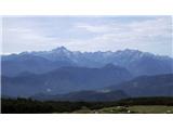
 | Jevšček - Monte Mataiur/Matajur
Matajur is a panoramic mountain located on the border between Slovenia and Italy. From the summit there is a beautiful view of Kobariški or Bregi...
2 h 30 min |
 | NC Planica - Glave (by ski jumping hill)
Glave is an indistinct side ridge of Ponca, rising steeply west of Planica. Maps incorrectly label its highest peak (1,760 m) as Ovčja stran; tha...
2 h 30 min |
| Rateče (Ledine) - Glave
Glave is an indistinct side ridge of Ponca, rising steeply west of Planica. Maps incorrectly label its highest peak (1,760 m) as Ovčja stran; tha...
2 h 50 min |
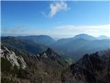
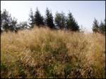
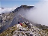
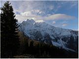
 | Markova raven - Krvavec (on unmarked path via Razor)
Krvavec is a 1,853-meter-high peak located in the heart of the eponymous ski resort. From the summit, which is crisscrossed with cable cars, ther...
2 h 45 min |
 | Podbreg - Logarska peč
Logarska peč is a peak or viewpoint a few meters below the summit, rising steeply above the Logarska Valley. From Logarska peč there is a very ni...
2 h 20 min |
 | Rutarski gozd - Jehlc (Špičasta kupa)
Different maps list various names for Jehlc, which also vary in elevation. Locals call the peak Jehlc (1625 m), while newer maps show Jehelc and ...
2 h |
| Grant - Jehlc (Špičasta kupa)
Different maps list various names for Jehlc, which also vary in elevation. Locals call the peak Jehlc (1625 m), while newer maps show Jehelc and ...
2 h 45 min |
 | Povlje - Grebenc
Grebenc is a lesser-known peak that rises steeply above Mala and Velika Poljana. From this little-visited summit, on a clear day there is a nice ...
2 h 5 min |
| Povlje - Grebenc (by cart track)
Grebenc is a lesser-known peak that rises steeply above Mala and Velika Poljana. From this little-visited summit, on a clear day there is a nice ...
2 h 5 min |
 | Valley of stream Žep - Mali Travnik
Mali Travnik is a lesser-known peak located south of the more famous Veliki Travnik. From the partly vegetated summit, there is a nice view of th...
2 h 5 min |
 | Korensko sedlo - Kamnati vrh/Steinberg (via Jerebikovec)
Kamnati vrh is a 1621 m high mountain located north of Kranjska Gora. From the grassy summit, where a bench stands, there is no view due to the n...
2 h |
 | Ravne - Kleiner Frauenkogel/Koprivnjak
Koprivnjak (Mala Dovška Baba) is a 1754 m high peak on the Austrian side of the Karawanks. From the summit, where a cross and summit logbook stan...
2 h 20 min |
 | 2nd hairpin turn of Vršič road - Visoki Mavrinc (Za Kumlehom)
Visoki Mavrinc (Špica v Sedelcih) is a 1562 m high mountain between Suha, Mala, and Velika Pišnica. From the summit, where a wooden cross and ple...
2 h |
 | Rudnik v Topli - Končnikov vrh (Peca)
Končnikov vrh (German: Knieps) is a 2109 m high peak situated in the central part of Peca. From the grassy summit, there is a beautiful view of t...
2 h 30 min |
 | Rudnik v Topli - Velika glava (Peca)
Velika glava is a peak in the Peca range, located between Kordeževa glava and Končnikov vrh. From the summit, which borders Austria, a beautiful ...
2 h 30 min |
 | Mangartska planina - Šober / Monte Sciober Grande (via Dren)
Šober / Monte Sciober Grande is a 1,845 m high peak located between the Remšendol Valley and Jezerska Valley. From the summit there is a fine vie...
2 h 35 min |
 | Spodnje Danje - Altemaver (Ratitovec)
Altemaver (Ratitovec), at 1,678 meters, is the highest peak of Ratitovec. From its grassy summit, there is a beautiful view of the Julian Alps, J...
2 h 30 min |
 | Ljubelj - Spodnji Plot
Spodnji Plot is a 1,682 m high mountain located south of the slightly higher Vrh Ljubeljščice (Triangel). From the precipitous summit, popular ma...
1 h 45 min |
 | Srednji Vrh - Maloško poldne / Mallestiger Mittagskogel
Maloško poldne, or Mallestiger Mittagskogel in German, is a 1,823-meter-high peak on the border between Slovenia and Austria, precisely between T...
2 h 55 min |
 | Dom Pristava in Javorniški Rovt - Mala Golica
Mala Golica is a less distinct peak located east of Krvavka. From its grassy summit, there is a nice view of the Dravska dolina, Struško, parts o...
2 h 15 min |
 | Planina Blato - Krsteniški Stog (čez Krsteniški preval)
Krsteniški Stog, or Mali Stog, is a 1879 m high mountain rising steeply above the Krstenica mountain pasture. From the summit, where a stone cair...
2 h 25 min |
 | Srednji Vrh - Zajčnik
Zajčnik (also Blekova) is a 1746-meter-high peak situated northeast of Vošca. From the partly vegetated summit, which borders Slovenia and Austri...
2 h 10 min |
 | Makekova Kočna - Visoki vrh above Jezersko (via Javornik)
Visoki vrh is a 1459-meter-high mountain in the ridge between Makekovo Kočna and Ravenska Kočna. From the summit, there is a fine view toward Koč...
2 h 15 min |
 | Kal - Rušni vrh
Rušni vrh is a 1,786-meter-high peak located east of Črna Prst. From the summit, which features a border stone from the old Rapallo border, a bea...
2 h 20 min |
 | Vrh Bače - Rušni vrh
Rušni vrh is a 1,786-meter-high peak located east of Črna Prst. From the summit, which features a border stone from the old Rapallo border, a bea...
3 h |
 | Spodnje Danje - Kremant (Ratitovec)
Kremant is a 1,654 m high peak located on the western part of Ratitovec. From the summit, where a stamp is attached to a metal pole, a nice view ...
2 h 30 min |
 | Srnjak - Grpišca
Grpišca is a 1,676 m high grassy peak located in the main ridge of the Karavanke, more precisely between Kamnati vrh and Vošca. From the summit, ...
2 h |
 | Srnjak - Tamarča
Tamarča is a lesser-known peak located northwest of Vošca. From its summit, surrounded by larch forest, a nice view opens up onto the Martuljek m...
2 h 30 min |
 | Rateče - Monte Coppa
Kopa (Kopje on some maps), or Monte Coppa in Italian, is a 1496-meter-high peak on the Italian side of the Karawanks. The old Rapallo border once...
2 h |
 | Sele pri Cerkvi / Zell - Pfarre - Mejnik
Mejnik is a 1517-meter-high peak on the Austrian side of the Karawanks, more precisely in a side ridge of Košuta. On the forested summit is a bou...
1 h 55 min |
| Ridovc / Ridovcsäge - Mejnik (via valley of Mrzli potok)
Mejnik is a 1517-meter-high peak on the Austrian side of the Karawanks, more precisely in a side ridge of Košuta. On the forested summit is a bou...
2 h 5 min |
 | Šajda / Schaidasattel - Kravji vrh / Kuhberg (via Obirsko sedlo)
Kravji vrh / Kuhberg is a two-thousander on the Obir with two approximately equally high peaks. Apart from dwarf pines, there is nothing on the h...
2 h 45 min |
 | Šajda / Schaidasattel - Kravji vrh / Kuhberg (steep path)
Kravji vrh / Kuhberg is a two-thousander on the Obir with two approximately equally high peaks. Apart from dwarf pines, there is nothing on the h...
2 h 30 min |
 | Podkoren - Visoka Bavha
Visoka Bavha is a 1,650-meter-high peak located on the border ridge of the Karawanks. The view from the summit is better towards the Austrian sid...
2 h |
 | Srednji Vrh - Bele peči (Lepi vrh) (via Železnica)
Bele peči, properly also Peči or Na Pečeh (maps sometimes show Lepi vrh, which is incorrect Lepi vrh is actually a forested shoulder at the 1,47...
2 h 30 min |
| Srednji Vrh - Bele peči (Lepi vrh) (via valley of stream Žlebnica)
Bele peči, properly also Peči or Na Pečeh (maps sometimes show Lepi vrh, which is incorrect Lepi vrh is actually a forested shoulder at the 1,47...
2 h 45 min |
 | Tolminske Ravne - Grušnica (via planina na Kalu)
Grušnica is a 1,570-meter-high peak located between Čadrg, the Tolminka valley, and Tolminske Ravne. From the summit, which drops steeply toward ...
1 h 45 min |
 | Vodel - Gradovec
Gradovec is a 1,692-meter-high peak located north of the ridge of Spodnje Bohinjske gore, specifically above the mountain pasture Poljana. From t...
1 h 55 min |
 | Ambrož pod Krvavcem - Kržišče (Pokovše)
Kržišče, also known as Pokovše, is a panoramic peak located between the Jezerca pasture, Kriška planina, and Osredek pasture. From the top, there...
1 h 40 min |
 | Mislinjski graben (Pestotnik) - Ostruščica
Ostruščica is a 1,498-meter-high peak located west of the ski slopes on Rogla....
2 h 30 min |
 | Trbiž / Tarviso - Florjanka / Monte Florianca (on transport road)
Florjanka is a 1,653-meter-high mountain on the Italian side of the Julian Alps. At or just below the summit is a reservoir for snowmaking on the...
2 h 30 min |
 | Slovenji Plajberk / Windisch Bleiberg - Kosmatica / Kosmatitza
Kosmatica / Kosmatitza is a 1,659-meter-high peak entirely on the Austrian side of the Karawanks, north of Vrtača. From the summit, which is part...
3 h |
 | Bela Peč / Villa Bassa - Črni vrh / Colrotondo
Črni vrh / Colrotondo is a fairly panoramic peak located west to southwest of the Belopeška jezera lakes. From the summit, which features a hunti...
2 h |
 | Dovje - Bela peč (above Dovje)
Bela peč is a lesser-known peak located above the marked trail from Dovje to Dovška Baba. From the summit, there is a beautiful view to the south...
2 h |
| Dovje - Bela peč (above Dovje) (via Blažčeva skala)
Bela peč is a lesser-known peak located above the marked trail from Dovje to Dovška Baba. From the summit, there is a beautiful view to the south...
2 h 15 min |
 | Alpengasthof Scheikl - Hohe Veitsch (up along the southern ridge)
Hohe Veitsch is the highest peak of the Veitsch mountain range, located in the eastern part of the Northern Limestone Alps. From the summit, a be...
2 h 35 min |
 | Aflenz Kurort (Freibad Aflenz) - Schönleitenhaus (Windgrube) (on southern ridge)
The Schönleitenhaus hut is located just a few meters below the Windgrube summit. From the hut or the summit, there is a beautiful view of the sur...
3 h |
| Aflenz Kurort (Bürgergraben) - Schönleitenhaus (Windgrube) (on southern ridge)
The Schönleitenhaus hut is located just a few meters below the Windgrube summit. From the hut or the summit, there is a beautiful view of the sur...
3 h |