Grahovše - Veliki Javornik (Ženiklovec)
Starting point: Grahovše (800 m)
| Latitude/Longitude: | 46,3664°N 14,3518°E |
| |
Walking time: 2 h 45 min
Difficulty: easy unmarked way
Elevation gain: 916 m
Elevation difference along the route: 916 m
Map: Karavanke - osrednji del 1:50.000
Recommended equipment (summer):
Recommended equipment (winter): ice axe, crampons
Views: 15.979
 | 1 person like this post |
Access to starting point:
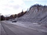
From the Ljubljana - Jesenice motorway take the Ljubelj (Tržič) exit, then continue driving towards Ljubelj. Just before the gas station in Bistrica pri Tržiču leave the main road and continue driving right towards Tržič. We then drive through Tržič towards Dolžanova soteska, and at the end of the town continue right towards Lom pod Storžičem and Grahovše. When we arrive in Grahovše drive along the road to the nearby quarry, next to which there is a marked parking lot.
Route description:
From the parking lot we continue along the road next to which we parked and after a few steps we come to two crossroads. At the first crossroads we continue straight ahead (right across the bridge is the village), at the second we come to the mountain signposts.
Here we turn left onto the upper path marked Javornik, Stegovnik and Bela peč. The road here begins to ascend moderately and leads us in places across panoramic meadows. The road then takes us to the next crossroads where we go left again (right is the Rekar farm).
The road then crosses private land where there is wood and soon after that reaches the next junction. Here we continue along the right road in the direction of Planina Javornik. The road from here onwards runs almost level for a while but then ascends again and takes us to a small hamlet. Here we continue ahead along the road which slowly turns left. Soon after the road makes a right bend and takes us to a signpost where the path to Bela peč branches off to the left.
Here we continue ahead along the road and follow it to the point where it starts to descend. After a few metres of descent we will notice the Pr Zdravc cottage on the right side, to which we have only a few steps left.
From the cottage we continue ahead along the poorer road which descends slightly, following it for just a few minutes to the nearby junction beside which stands a memorial marker.
Here we turn right onto the cart track which begins to ascend. After a few minutes of walking we emerge from the forest and soon reach the Planina Javornik where a few cottages stand.
Ahead we continue straight uphill first along the fence then along a trodden path across the meadow. After less than 30 minutes walking up the moderately steep slope we reach the panoramic summit.
Quarry - cottage Pr Zdravc 2:00, cottage Pr Zdravc - Planina Javornik 15 minutes, Planina Javornik - Veliki Javornik 30 minutes.

Photos:
 1
1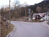 2
2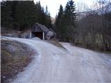 3
3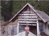 4
4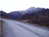 5
5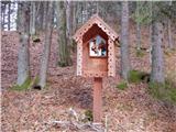 6
6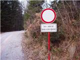 7
7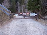 8
8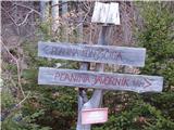 9
9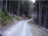 10
10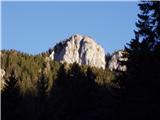 11
11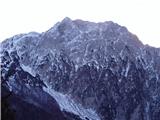 12
12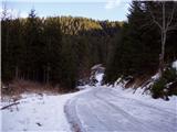 13
13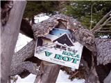 14
14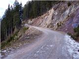 15
15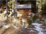 16
16 17
17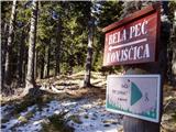 18
18 19
19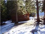 20
20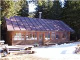 21
21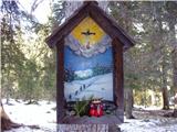 22
22 23
23 24
24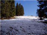 25
25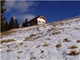 26
26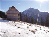 27
27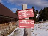 28
28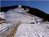 29
29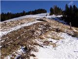 30
30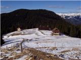 31
31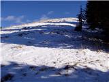 32
32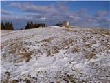 33
33 34
34
Discussion about the trip Grahovše - Veliki Javornik (Ženiklovec)
|
| Gost19. 01. 2007 |
I did this trip two years ago, the view from the top is very nice. Now I have a question because the trail description is not quite clear to me: as I see in the pictures, the road is blocked with a barrier in one section, and before that there's a sign "private road" (?). A bit further in the description I read that the same road leads to a small hamlet. So is the road private property of all the residents of that hamlet, or how? Given the hamlet, I assume there must be a public road leading to it somewhere? Can someone who knows the conditions and was there recently explain how it is?
|
|
|
|
| Gost19. 01. 2007 |
As far as could be seen, it is possible to drive on this road but at your own risk. The gate in the picture can be opened and driving through is not prohibited but it is desirable to leave this area with as little noise as possible. Just a few meters behind this gate there is a municipal sign indicating that the road is open but still at your own risk. So it is possible to reach the hut on Javornik by road.
|
|
|
|
| Gost20. 01. 2007 |
Yes, that's what it says on the sign, but the traffic sign above it means "prohibited for all traffic" (at least a few decades ago when I was taught about it in driving school it was like that  ). On the gate I see the inscription "permitted for landowners and forest management". Since I am neither a landowner nor a forester, but just a somewhat older hill visitor who likes to shorten the paths a bit (especially on roads), because I can no longer manage very long walks, but still love walking in the mountains very much, these peaks around here are becoming a "prohibited area" for me, and I'm a bit sad about that ). On the gate I see the inscription "permitted for landowners and forest management". Since I am neither a landowner nor a forester, but just a somewhat older hill visitor who likes to shorten the paths a bit (especially on roads), because I can no longer manage very long walks, but still love walking in the mountains very much, these peaks around here are becoming a "prohibited area" for me, and I'm a bit sad about that 
|
|
|
|
| Gost20. 01. 2007 |
There is a collection box at the barrier where they collect money for the maintenance of private roads. So why would you put something in the collection box if you shouldn't. Otherwise, it is possible to get to the hut also by another road. From Tržič you drive towards the house under Storžič. When you notice the intersection on the asphalt road in a long right bend, turn left. Further see the map. A few years ago I returned on this road and I got there normally. There is also a sign prohibited for all traffic with a supplementary plate use at own risk.
|
|
|
|
| Gost20. 01. 2007 |
I think that regarding barriers, collection boxes, road maintenance, such and other signs you dear Tržič people should turn to another address. Or will you find a new bone again and inform the whole web how dissatisfied you are with everything. Leave this page to the mountaineers,
|
|
|
|
| Gost21. 01. 2007 |
Does this ramp have a building permit or is it built illegally? Like most others.
|
|
|
|
| Gost21. 01. 2007 |
So there is no misunderstanding - I am the one who asked how it is with the drivability of this road, and with that I didn't mean anything bad, I just wanted to get information and possibly an idea where else one could drive a bit higher (and I got that idea, so for me this discussion is closed). And - I AM NOT A TRŽIČANKA, but a "pure-blooded" Ljubljančanka!
|
|
|
|
| Gost22. 01. 2007 |
Why didn't you go to the hamlet and get info first-hand? You can see you just want to chirp something..... Pure-blooded Ljubljana girl. You don't go to the mountains by car. On foot as much as a person can manage.
|
|
|
|
| Gost24. 01. 2007 |
How beautiful the world would be if there were more tolerance. Then such a debate would be unnecessary. People, let others live as they think is best for them. Whoever thinks they must walk more, let them walk, if someone feels like driving under the mountain, let them drive. There's enough space under this sun for everyone. Who knows why some find it convenient to drive up a bit by car.
|
|
|
|
| Gost24. 01. 2007 |
When I read this debate and the last sentence of the previous post, I can't help but state my opinion on driving to the mountains, supported by several personal experiences. Once I was at the Blejska Koča on Lipanca when 3 people entered - an elderly man supported by two companions on each side so he could walk from the door to the table. They had driven him there because he wanted to see the place one more time where he had hiked all his life. It seemed very nice to me. Another example: On the way back from a medium-high summit, I overtook parents with a child. The father was carrying the about 4 or 5-year-old child in a special backpack. Why? The parents like hiking, the child enjoys it too, but since birth he is so physically impaired that he can't walk (in the valley he uses a wheelchair). Why not solve the problem at least temporarily (while the child is light enough) by driving as high as possible and then enjoying the mid-mountains? There are probably many such or similar cases. I also appreciate the effort of all elderly or somehow physically impaired people who strive to stay active by coming to enjoy a bit higher according to their abilities, even if they drive up some road to a higher starting point. After all, I don't park in Mojstrana when I head to Triglav either...
|
|
|
|
| Gost24. 01. 2007 |
Exactly that was on my mind as the guest behind me described. And it's right that those who have to put in much more effort (even if they do part of the way by car) also enjoy the mountains, compared to someone who is still young and bursting with energy and for whom it's a piece of cake from the bus or train station to the top. In my young years, when cars were rare, we also "ground" asphalt. And it will never be forgotten when we came from the Vrata to Mojstrana for the bus (after descending from Kredarica), it didn't pick us up and we had to walk to the train station in Jesenice in the rain. Despite our youth, it would have been really welcome if someone had taken pity on us and given us a ride. So everyone will hike in the mountains according to their strength and I strongly hope until old age (even if some grandson drives us to the nearest starting point). Good luck and safe travels!
|
|
|
|
| klavdipo15. 11. 2008 |
Is there a stamp at the top too?
|
|
|
|
| ben16. 11. 2008 |
When I was up there in May this year, there was a stamp!
LP
|
|
|
|
| andrej jerina16. 11. 2008 |
Klavdij, the stamp at the top is in the summit log box, but today there was quite a bit of water in it, a soggy book and a very damaged stamp, so you can't use it. LP Andrej
|
|
|
|
| kontiki28. 05. 2017 |
Is the stamp still up there on the summit?
|
|
|
|
| serajko28. 05. 2017 |
kontiki
Check the date of the previous comment
|
|
|
|
| aditaker20. 07. 2018 |
I'm also interested if there's a stamp at the top and if it's still usable?
Best regards, Rok
|
|
|
|
| Acibujl23. 01. 2025 16:23:29 |
19 January 2025: past the parking at the quarry to the last one before the no-entry sign towards Dom pod Storžičem, eazy parking app, 3€/day (poor signal!). Along the road and partly marked trail in the upper part to the hut, less than an hour, medium pace.  From the hut, descend to the gravel road below, red signs and markers already visible.. direction Javorniški preval and planina Javornik. Nicely followable on the track, partly through forest, you can choose, better on the road as it was more slippery in the forest... at the saddle left towards planina Javornik. To it all nicely marked. On the bench rest & schnapps in the sun (inversion) above the planina the summit Veliki Javornik or Ženiklovec? What's correct, with o or a? Footprints sparse, visitors rare (too little snow?) we go a bit off-trail to the summit (about 30 min), which offers wide views: Kočna, Kalški greben, Krvavec, Mali Grintavec, Bašeljski vrh, Storžič, Tolsti vrh, Kriška gora, entire Košute ridge, Julijci with the highest, Vrtača Stol, Begunjščica, Bela peč in the foreground, from planina 1.5 hours marked... Easy orientation, when you reach the planina, look up and see where to go! I imagine what a paradise for ski tourers this summit must be in snow! We two enjoyed the solitude, met only a couple with a dog on the way, in the logbook no one signed since 5 January! Descent back with crampons, why carry them just in the backpack? Hut already closed on return From the hut, descend to the gravel road below, red signs and markers already visible.. direction Javorniški preval and planina Javornik. Nicely followable on the track, partly through forest, you can choose, better on the road as it was more slippery in the forest... at the saddle left towards planina Javornik. To it all nicely marked. On the bench rest & schnapps in the sun (inversion) above the planina the summit Veliki Javornik or Ženiklovec? What's correct, with o or a? Footprints sparse, visitors rare (too little snow?) we go a bit off-trail to the summit (about 30 min), which offers wide views: Kočna, Kalški greben, Krvavec, Mali Grintavec, Bašeljski vrh, Storžič, Tolsti vrh, Kriška gora, entire Košute ridge, Julijci with the highest, Vrtača Stol, Begunjščica, Bela peč in the foreground, from planina 1.5 hours marked... Easy orientation, when you reach the planina, look up and see where to go! I imagine what a paradise for ski tourers this summit must be in snow! We two enjoyed the solitude, met only a couple with a dog on the way, in the logbook no one signed since 5 January! Descent back with crampons, why carry them just in the backpack? Hut already closed on return ... past it following markers to the car. I recommend visiting these places! ... past it following markers to the car. I recommend visiting these places!
|
|
|
|
| Macesna23. 01. 2025 18:29:06 |
Nice tour.
Correct is Ženiklovec. LP
|
|
|
|
| Kafetarca23. 01. 2025 19:20:14 |
Wait, is the parking at Dom pod Storžičem already paid now? 
|
|
|
|
| Daaam23. 01. 2025 19:52:46 |
At Dom pod Storžičem it's still free. But it's paid along the road from Grahovše onwards in the valley until the road starts ascending. I think there are about three parking spots
|
|
|
|
| plaNinaPirsMajcen2. 01. 2026 17:39:48 |
Hi, after a year I returned in winter to this heavenly beautiful place with fascinating views, namely captured sunset from the top of Ženiklovec.
An aesthetic video was created, higher quality than last year's beginner one 😊
https://youtu.be/Jhm-wHLF9Gw?si=iitU4wdrKyMI-llX
Recorded on 29.12.2025
Ženiklovec is a safe choice in winter, crampons recommended.
Best regards, Nina
|
|
|
To post a comment you must log in:
If you do not yet have a username, you must first
register.