 | Polhov Gradec (Božna) - Polhograjska Grmada (via Mačkov graben)
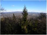
Polhograjska Grmada is an 898 m high peak located in the heart of the Polhograjski Dolomites. From the summit, which has a registration box with ...
1 h 30 min |
 | Žlebe - Sveti Jakob (via Turnice)
The Church of St James is located on a hill north of the village of Topol near Medvode. From the top, where there is a registration box with a st...
2 h |
| Žlebe - Sveti Jakob (via Jeterbenk)
The Church of St James is located on a hill north of the village of Topol near Medvode. From the top, where there is a registration box with a st...
2 h 15 min |
 | Slavkov dom na Golem Brdu - Sveti Jakob
The Church of St James is located on a hill north of the village of Topol near Medvode. From the top, where there is a registration box with a st...
2 h 5 min |
 | Topol - Tošč (direct way)
Tošč, which became the highest peak of Polhograjsko hribovje decades ago when Pasja ravan was lowered by 9 m by the Yugoslav army, is located nor...
2 h |
 | Trnovec - Tošč
Tošč, which became the highest peak of Polhograjsko hribovje decades ago when Pasja ravan was lowered by 9 m by the Yugoslav army, is located nor...
1 h 35 min |
 | Gabrovo - Lubnik
Lubnik is a 1025 m high mountain rising steeply to the west of Škofja Loka. From the summit, on which the mountain lodge stands, you can enjoy a ...
1 h 30 min |
 | Na Poklonu - Lubnik
Lubnik is a 1025 m high mountain rising steeply to the west of Škofja Loka. From the summit, on which the mountain lodge stands, you can enjoy a ...
2 h 15 min |
 | Vače - Zasavska Sveta gora
Zasavska Sveta gora is a popular excursion point located between Litija and Izlaki. From the top, where the parish church of the Nativity of the ...
2 h |
 | Vače - Zasavska Sveta gora (on a slope)
Zasavska Sveta gora is a popular excursion point located between Litija and Izlaki. From the top, where the parish church of the Nativity of the ...
2 h 30 min |
| Vače - Zasavska Sveta gora (on the ridge)
Zasavska Sveta gora is a popular excursion point located between Litija and Izlaki. From the top, where the parish church of the Nativity of the ...
2 h 35 min |
 | Legastja - Jeterbenk
Jeterbenk is a 774 m high peak located between Slavko's home at Gole Brdo and Katarina (Topol village). From the top, where there is a large cros...
1 h 40 min |
 | Zalog - Polhograjska Gora (Sveti Lovrenc) (gentle path)
Polhograjska Gora, also just Gora or Sveti Lovrenc, is an 824 m high hill located north-west of Polhov Gradec. From the top of the hill, where th...
1 h 30 min |
 | Selo - Pasja ravan (via Ostrež)
Pasja ravan is the second highest peak in the Polhograje Hills. A few decades ago, at 1029 m, it was the highest peak, but the Yugoslav army flat...
2 h 15 min |
 | Koroška Bela - Ajdna
Ajdna is a peak with a beautiful view of Hochstuhl, Jelovica, Pokljuka and the Julian Alps. Part of the Gornjesavska valley between Žirovnica and...
1 h 30 min |
 | Blagovica - Limbarska gora
Limbarska gora is located north-east of Moravce. From the top there is a beautiful view of the surrounding peaks and in good weather you can also...
1 h 30 min |
 | Crngrob - Archangel Gabriel (Planica)
Planica is an 824 m high peak located north of Škofja Loka, between Krizna Gora and Planica. From the top, where the Church of St. Gabriel the Ar...
1 h 30 min |
 | Moškrin - Archangel Gabriel (Planica)
Planica is an 824 m high peak located north of Škofja Loka, between Krizna Gora and Planica. From the top, where the Church of St. Gabriel the Ar...
1 h 30 min |
 | Pevno - Archangel Gabriel (Planica)
Planica is an 824 m high peak located north of Škofja Loka, between Krizna Gora and Planica. From the top, where the Church of St. Gabriel the Ar...
1 h 30 min |
 | Gabrče - Vremščica
Vremščica is a mountain chain, stretching between Senožeče, Pivka and Divača. The highest top is also called Vremščica and the view from it is am...
2 h |
| Senožeče - Vremščica
Vremščica is a mountain chain, stretching between Senožeče, Pivka and Divača. The highest top is also called Vremščica and the view from it is am...
1 h 45 min |
 | Volče - Vremščica
Vremščica is a mountain chain, stretching between Senožeče, Pivka and Divača. The highest top is also called Vremščica and the view from it is am...
1 h 30 min |
 | Rovte - Vrh Svetih Treh Kraljev (steep path)
The Church of the Holy Three Kings is situated on a lookout above the village of Vrh Svetih Treh kraljev. From the top, which has an observation ...
1 h 25 min |
| Rovte - Vrh Svetih Treh Kraljev (gentle path)
The Church of the Holy Three Kings is situated on a lookout above the village of Vrh Svetih Treh kraljev. From the top, which has an observation ...
1 h 30 min |
 | Sopot - Vrh Svetih Treh Kraljev
The Church of the Holy Three Kings is situated on a lookout above the village of Vrh Svetih Treh kraljev. From the top, which has an observation ...
1 h 25 min |
 | Žiri - Vrh Svetih Treh Kraljev
The Church of the Holy Three Kings is situated on a lookout above the village of Vrh Svetih Treh kraljev. From the top, which has an observation ...
2 h 30 min |
 | Veliko Trebeljevo - Janče
Janče is a 792-metre-high peak located between the Sava River and the valley of the Besnica Stream. From the top, where the mountain lodge stands...
2 h 15 min |
 | Sveta Trojica - Cicelj
Cicelj is a forested peak located between Moravče and the village of Senožeti. There is no view from the top, which has a bench and a registratio...
1 h 45 min |
 | Zaplana (Prezid) - Ulovka
Ulovka is the peak between Zaplana and the Shelter at Mountain pasture above Vrhnika. From the top, which is reached by ski lifts, there is a nic...
1 h 45 min |
 | Podgorje - Slavnik (gentle path)
Slavnik is a scenic mountain rising south of Kozina and west of Podgorje. Podgorje is a village which is a suitable starting point for ascending ...
1 h 40 min |
 | Skadanščina - Slavnik
Slavnik is a scenic mountain rising south of Kozina and west of Podgorje. Podgorje is a village which is a suitable starting point for ascending ...
1 h 40 min |
 | Katarija - Slivna (Pivkelj)
Slivna or Pivkelj (also Pivkelj turn) as this peak is also called is located south of Limbarska Gora. Pivkelj is also the highest point of the Mo...
1 h 55 min |
 | Kandrše (Trata) - Slivna (Pivkelj) (via Sveti Florjan)
Slivna or Pivkelj (also Pivkelj turn) as this peak is also called is located south of Limbarska Gora. Pivkelj is also the highest point of the Mo...
2 h 20 min |
| Kandrše (Trata) - Slivna (Pivkelj) (via GEOSS)
Slivna or Pivkelj (also Pivkelj turn) as this peak is also called is located south of Limbarska Gora. Pivkelj is also the highest point of the Mo...
2 h |
 | Jablanica - Srednji vrh at Kozlek
Srednji vrh is a scenic mountain located west of Ilirska Bistrica, near the better known Kozlek. From the top there is a beautiful view down to t...
1 h 25 min |
 | Sovodenj - Bevkov vrh (gentle path)
Bevkov vrh, which is a point on the Slovenian mountain trail, is located between Cerkno and Spodnja Idrija. The summit is covered with forest and...
1 h 30 min |
 | Jazne (Lanišar) - Sivka
Sivka is a forested peak located west of Žiri and north of Idrija. On the summit there is a stamp of the Slovenian mountain trail and a registrat...
1 h 30 min |
 | Govejk - Sivka
Sivka is a forested peak located west of Žiri and north of Idrija. On the summit there is a stamp of the Slovenian mountain trail and a registrat...
1 h 40 min |
 | Sovodenj - Sivka
Sivka is a forested peak located west of Žiri and north of Idrija. On the summit there is a stamp of the Slovenian mountain trail and a registrat...
2 h |
 | Zagreben (pri Dikcu) - Malič
Malič is a 936 m high peak located between Celje and Laško, above Spodnja Rečica. There is no better view from the top, where the transmitter, be...
1 h 30 min |
 | Čretvež - Stolpnik (via Grofov štant)
At 1012 m, Stolpnik is the highest peak of the Konjiška Gora, a mountain range stretching south-west from Slovenske Konjice. A 25 m high lookout ...
1 h 35 min |
 | Čretvež - Stolpnik (via Hunting cottage Štepih)
At 1012 m, Stolpnik is the highest peak of the Konjiška Gora, a mountain range stretching south-west from Slovenske Konjice. A 25 m high lookout ...
1 h 25 min |
 | Črešnjice - Stolpnik
At 1012 m, Stolpnik is the highest peak of the Konjiška Gora, a mountain range stretching south-west from Slovenske Konjice. A 25 m high lookout ...
1 h 25 min |
 | Stara Žaga - Skalica (Bohor) (via Možnica)
Skalica is a less known peak in the western part of Bohor. From the summit, which has a registration box, there is a beautiful view to the south ...
1 h 40 min |
 | Planina pri Sevnici - Skalica (Bohor) (via hunting lodge Bohor)
Skalica is a less known peak in the western part of Bohor. From the summit, which has a registration box, there is a beautiful view to the south ...
2 h |
 | Stara Žaga - Veliki Javornik (Bohor) (via Skalica)
Veliki Javornik is the highest peak of Bohor at 1023m. Although the peak is unspoilt and there are no higher hills far around, there is no view f...
2 h 10 min |
 | Šentvid pri Planini - Veliki Javornik (Bohor)
Veliki Javornik is the highest peak of Bohor at 1023m. Although the peak is unspoilt and there are no higher hills far around, there is no view f...
2 h |
 | Planina pri Sevnici - Koprivnik (Bohor)
Koprivnik or Veliki Koprivnik is one of the many peaks in Bohor. It is located between Koča na Bohorju and Veliki Koprivnik. From the top of the ...
2 h |
| Šentvid pri Planini - Koprivnik (Bohor)
Koprivnik or Veliki Koprivnik is one of the many peaks in Bohor. It is located between Koča na Bohorju and Veliki Koprivnik. From the top of the ...
1 h 30 min |
 | Nova Štifta - Koča na Kamnem griču
The cottage is located on Kamný hill, a scenic peak rising south-west of Sodražica. The grassy summit, surrounded by forest, offers a beautiful v...
1 h 35 min |
 | Žlebe - Rog (via Turnice)
The Rog is a 798 m high peak located above the village of Topole, just 10 minutes from St Catherine's Church. From the top of the hill, where a l...
1 h 30 min |
| Žlebe - Rog (via Jeterbenk)
The Rog is a 798 m high peak located above the village of Topole, just 10 minutes from St Catherine's Church. From the top of the hill, where a l...
1 h 40 min |
 | Sovodenj - Ermanovec (razgledna pot)
Ermanovec is a 1026 m high peak located between Cerkno and Gorenjska vasja, specifically above Sovodnje and Trebija. Just a few steps away from t...
2 h |
| Sovodenj - Ermanovec (through Miklavževa grapa)
Ermanovec is a 1026 m high peak located between Cerkno and Gorenjska vasja, specifically above Sovodnje and Trebija. Just a few steps away from t...
1 h 40 min |
 | Sovodenj - Ermanovec (by road)
Ermanovec is a 1026 m high peak located between Cerkno and Gorenjska vasja, specifically above Sovodnje and Trebija. Just a few steps away from t...
1 h 40 min |
 | Skadanščina - Velika Plešivica
Velika Plešivica is a 908 m high peak located between Slavnik and the less known Mala Plešivica. From the top of the summit, where the destroyed ...
2 h 15 min |
 | Velike Lašče - Kamen vrh (via Gornje Retje and Grmada)
Kamen vrh is a scenic peak located on the northern outskirts of Mala Gora. From the top, surrounded by low bushes, there is a beautiful view of p...
2 h 35 min |
 | Ribnica (Lepovče) - Stene svete Ane
Stene svete Ane is a vegetated peak located near the mountain hut at Sveti Anna on Mali gora. A small observation tower stands on the summit, whi...
1 h 35 min |
 | Ortnek - Stene svete Ane
Stene svete Ane is a vegetated peak located near the mountain hut at Sveti Anna on Mali gora. A small observation tower stands on the summit, whi...
2 h 30 min |
 | Suhi Dol - Sivka (through forest)
Sivka is a grassy peak located in the westernmost part of the Polhograje Hills. In good weather, the peak offers a magnificent view from Snežnik ...
1 h 30 min |
| Suhi Dol - Sivka (by road)
Sivka is a grassy peak located in the westernmost part of the Polhograje Hills. In good weather, the peak offers a magnificent view from Snežnik ...
1 h 40 min |
| Ljubljanica - Sivka
Sivka is a grassy peak located in the westernmost part of the Polhograje Hills. In good weather, the peak offers a magnificent view from Snežnik ...
2 h 25 min |
 | Kočevje - Fridrihštajn Castle (Grajska way)
Fridrihštajn Castle, built in the 15th century, is located to the south of Kočevje on a 970m high hill. Today, only the ruins of the castle remai...
1 h 30 min |
 | Veliki Boč (Zgornji Kovač) - Žavcarjev vrh
Žavcarjev vrh is a 915m high mountain located north of the River Drava on the slopes of Kozjak. As the peak is completely overgrown, there is no ...
1 h 25 min |
 | Grčarevec - Grmada (Planinska gora) (Jakobova pot)
Grmada is an 873m high peak rising west of Planinsko Polje. The summit is overgrown, but from the lookout point just below the summit we have a b...
1 h 50 min |
 | Potoška vas - Sveta planina (Partizanski vrh)
Sveta planina, also Partizanski vrh, is a 1011 m high mountain located between Čemšeniška mountain pasture and Mrzlica. From the top, where a sma...
1 h 30 min |
 | Dom pod Reško planino - Sveta planina (Partizanski vrh)
Sveta planina, also Partizanski vrh, is a 1011 m high mountain located between Čemšeniška mountain pasture and Mrzlica. From the top, where a sma...
2 h 5 min |
 | Radeljski prelaz - Kapunar / Kapunerkogel
Kapunar is a 1051 m high peak above Radlje ob Dravi. Just below the peak is an old caravan and border guardhouse, which is now used by radio amat...
1 h 40 min |
 | Sveti Jurij (Remšnik) - Kapunar / Kapunerkogel
Kapunar is a 1051 m high peak above Radlje ob Dravi. Just below the peak is an old caravan and border guardhouse, which is now used by radio amat...
2 h |
 | Stara Fužina - Rudnica (by road)
Rudnica is a scenic mountain located between the Lower and Upper Bohinj Valley. From the top, where there is a registration box with a stamp and ...
1 h 40 min |
 | Jezersko polje - Rudnica
Rudnica is a scenic mountain located between the Lower and Upper Bohinj Valley. From the top, where there is a registration box with a stamp and ...
1 h 45 min |
 | Brod - Rudnica (via Široka polica)
Rudnica is a scenic mountain located between the Lower and Upper Bohinj Valley. From the top, where there is a registration box with a stamp and ...
1 h 25 min |
| Savica - Rudnica (via Široka polica)
Rudnica is a scenic mountain located between the Lower and Upper Bohinj Valley. From the top, where there is a registration box with a stamp and ...
1 h 25 min |
 | Trnovec - Gontarska planina
Gontarska planina is an 894 m high mountain located between Osolnik and Tosce. From the top, where there are two benches, we have a beautiful vie...
1 h 30 min |
 | Trojane - Špilk
Špilk is a 956 m high peak located north of Blagovica. On the summit, which is mostly forested, PD Blagovica has built a small bivouac with a ben...
2 h 30 min |
 | Trojane - Špilk (past the cross Na Kočni)
Špilk is a 956 m high peak located north of Blagovica. On the summit, which is mostly forested, PD Blagovica has built a small bivouac with a ben...
2 h 15 min |
 | Mislinja - Fričev vrh (via Črepič)
Fričev vrh is an 881 m high hill located south of Mislinja Dobrava. There is no view from the top, which has a registration box with a registrati...
1 h 35 min |
 | Mislinja - Fričev vrh (via Završe)
Fričev vrh is an 881 m high hill located south of Mislinja Dobrava. There is no view from the top, which has a registration box with a registrati...
2 h |
 | Zazid - Golič
Golič is a grassy ridge stretching from Kojnik to the Slovenian-Croatian border and continuing to Žbevnica on the Croatian side. Due to the relat...
1 h 30 min |
 | Kopačnica - Štor
Štor is a 1005 m high peak located directly above the Ermanovec Cottage. The peak itself is covered with forest, but from the meadow, which is on...
1 h 25 min |
| Sovodenj - Štor (through Miklavževa grapa)
Štor is a 1005 m high peak located directly above the Ermanovec Cottage. The peak itself is covered with forest, but from the meadow, which is on...
1 h 25 min |
| Sovodenj - Štor (razgledna pot)
Štor is a 1005 m high peak located directly above the Ermanovec Cottage. The peak itself is covered with forest, but from the meadow, which is on...
1 h 45 min |
| Sovodenj - Štor (by road)
Štor is a 1005 m high peak located directly above the Ermanovec Cottage. The peak itself is covered with forest, but from the meadow, which is on...
1 h 35 min |
 | Čepulje - Sveti Mohor (Zabrekve)
The Church of St. Mohor is situated on a 952 m high hill, between Zgornja Besnica and Selce. From the church, or its immediate surroundings, we h...
1 h 30 min |
 | Podblica - Sveti Mohor (Zabrekve)
The Church of St. Mohor is situated on a 952 m high hill, between Zgornja Besnica and Selce. From the church, or its immediate surroundings, we h...
1 h 40 min |
 | Zgornja Besnica (Podrovnik) - Špičasti hrib
Špičasti hrib (Špičasti vrh on maps) is an 837 m high peak located to the west of Sveti Jošto above Kranj. There is no view from the top, which h...
1 h 30 min |
 | Spodnja Besnica (fish farm) - Špičasti hrib
Špičasti hrib (Špičasti vrh on maps) is an 837 m high peak located to the west of Sveti Jošto above Kranj. There is no view from the top, which h...
1 h 30 min |
 | Zazid - Lipnik
Lipnik is an 804 m high peak located above the village of Rakitovec on the Slovenian Croatian border. From the top, where there is a cross and a ...
1 h 40 min |
 | Sveti Mavricij - Sveti Socerb (Artviže)
The Church of St. Socerbo is situated on a hill overloking the village of Artviže, which is the highest peak in Brkina with its 817 m. The church...
2 h 15 min |
 | Dolenji Novaki (Pod Kovkom) - Škofje
Škofje is a 973 m high peak located above the villages of Čeplez, Planina pri Cerknem and Podpleče. The peak itself, on which stands a small conc...
2 h |
 | Ledinsko Razpotje - Loncmanova Sivka (Mrzli Vrh)
Loncmanova Sivka is a scenic peak located above the village of Mrzli Vrh above Žirmi. From the uncultivated peak, in good weather, we can enjoy v...
1 h 25 min |
| Govejk - Loncmanova Sivka (Mrzli Vrh)
Loncmanova Sivka is a scenic peak located above the village of Mrzli Vrh above Žirmi. From the uncultivated peak, in good weather, we can enjoy v...
1 h 40 min |
 | Sovodenj - Loncmanova Sivka (Mrzli Vrh)
Loncmanova Sivka is a scenic peak located above the village of Mrzli Vrh above Žirmi. From the uncultivated peak, in good weather, we can enjoy v...
2 h |
| Jazne (Lanišar) - Loncmanova Sivka (Mrzli Vrh)
Loncmanova Sivka is a scenic peak located above the village of Mrzli Vrh above Žirmi. From the uncultivated peak, in good weather, we can enjoy v...
1 h 30 min |
 | Vinska Gora - Radojč (easy path)
Radojč is a 937 m high peak located north of Vinská Gora. The summit, which has a registration box with a registration book and a stamp, has no v...
1 h 30 min |
 | Krače - Roviškovec (west path)
Roviškovec (also Roviški vrh) is a 930 m high peak located southeast of Zasavska Svatá gora. From the top, which is mostly covered with forest an...
1 h 30 min |
 | Krače - Pleše
Pleše is an 866 m high peak located between the Marela Ski Resort and Zasavska Sveta Gora. From the top, where the NOB monument is located, you h...
1 h 45 min |
 | Šembije - Ahac
Ahac or St. Ahac is a 799 m high peak located east of Ilirska Bistrica. The summit, which is home to a registration box, a cross and the ruins of...
2 h |
 | Tržič - Veliki vrh above Završnik (via Kamnek)
Veliki vrh above Završnik is a 968 m high mountain located in the Pirmance ridge, north to north-east of Tržič. From the grassy summit, where the...
1 h 45 min |
| Tržič - Veliki vrh above Završnik (below Kamnek)
Veliki vrh above Završnik is a 968 m high mountain located in the Pirmance ridge, north to north-east of Tržič. From the grassy summit, where the...
1 h 40 min |
 | Greuth - Große Muschenig (via Maria Elender Alm)
Große Muschenig, or after German. Große Muschenig is a 1021-metre-high peak located on the Austrian side of Karawanks, more precisely between the...
1 h 45 min |
| Greuth - Große Muschenig (via Hasengraben)
Große Muschenig, or after German. Große Muschenig is a 1021-metre-high peak located on the Austrian side of Karawanks, more precisely between the...
1 h 45 min |
 | Dolenja Dobrava - Javorč
Javorč is a 901-metre-high peak located to the north-east of Žiri. The summit, where the registration box with the registration book is located, ...
1 h 30 min |
 | Planina pri Sevnici - Debeli vrh (Bohor)
Debeli vrh is a 921-metre-high peak on Bohor between Veliki Koprivnik and Oslice. It is overgrown with dense forest, so there are no views. There...
2 h 30 min |
| Jablance - Debeli vrh (Bohor)
Debeli vrh is a 921-metre-high peak on Bohor between Veliki Koprivnik and Oslice. It is overgrown with dense forest, so there are no views. There...
1 h 35 min |
| Šentvid pri Planini - Debeli vrh (Bohor)
Debeli vrh is a 921-metre-high peak on Bohor between Veliki Koprivnik and Oslice. It is overgrown with dense forest, so there are no views. There...
2 h |
 | Planina pri Sevnici - Brest (Bohor) (via Škofov travnik)
Brest is a peak on Bohor although it loks more like a saddle. It is an important intersection of the Bohor trails. It lies between Oslica, which ...
2 h 35 min |
| Planina pri Sevnici - Brest (Bohor) (northern path)
Brest is a peak on Bohor although it loks more like a saddle. It is an important intersection of the Bohor trails. It lies between Oslica, which ...
2 h 20 min |
| Jablance - Brest (Bohor) (via Koča na Bohorju)
Brest is a peak on Bohor although it loks more like a saddle. It is an important intersection of the Bohor trails. It lies between Oslica, which ...
1 h 40 min |
| Šentvid pri Planini - Brest (Bohor) (via Škofov travnik)
Brest is a peak on Bohor although it loks more like a saddle. It is an important intersection of the Bohor trails. It lies between Oslica, which ...
2 h 5 min |
| Šentvid pri Planini - Brest (Bohor) (northern path)
Brest is a peak on Bohor although it loks more like a saddle. It is an important intersection of the Bohor trails. It lies between Oslica, which ...
1 h 50 min |
 | Lovrenc na Pohorju - Hlebov vrh (Rdeči Breg)
The Red Bank stretches between the Radoljna Gorge in the east, the Drava River in the north and the Velka Stream in the east. It is separated fro...
2 h 10 min |
 | Janževski Vrh (Uran) - Hlebov vrh (Rdeči Breg)
The Red Bank stretches between the Radoljna Gorge in the east, the Drava River in the north and the Velka Stream in the east. It is separated fro...
1 h 30 min |
| Janževski Vrh (Uran) - Hlebov vrh (Rdeči Breg) (via Brabar)
The Red Bank stretches between the Radoljna Gorge in the east, the Drava River in the north and the Velka Stream in the east. It is separated fro...
1 h 40 min |
 | Travnarjev gozd (Hotenjsko podolje) - Šenčurjev vrh
Šenčurjev vrh is a 725-metre-high hill located above the settlement Žibrše, between Logatec, Hotedršica and Rovtami. At the top, which offers a b...
1 h 50 min |
 | Hunting cottage Budanje - Podrta gora above Ajdovščina
Podrta gora above Ajdovščina, also called the Broke Mountain above Šturje, is a mountain rising above the Vipava valley. Some time ago, a large c...
1 h 35 min |
| Col - Podrta gora above Ajdovščina
Podrta gora above Ajdovščina, also called the Broke Mountain above Šturje, is a mountain rising above the Vipava valley. Some time ago, a large c...
1 h 45 min |
 | Hunting cottage Budanje - Kraguljc
Kraguljc is a mountain located between Podrto gora and Sončnica. A trigonometric point is located on the lookout point, which offers a beautiful ...
1 h 25 min |
| Col - Kraguljc
Kraguljc is a mountain located between Podrto gora and Sončnica. A trigonometric point is located on the lookout point, which offers a beautiful ...
1 h 35 min |
 | 18th hairpin turn of road on Strma Reber - Loška stena
Loška stena is located above the Upper Kolpa Valley, specifically above the villages of Grintovec pri Osilnici, Ložec and Ribjek. From the top of...
2 h 25 min |
 | Terme Topolšica - Lomek (Lom)
Lom, with its highest peak Lomek (884 m), is an peak of karst origin, located above the tourist and health resort of Topolšica. From the top, you...
1 h 50 min |
 | Poljana - Volinjak (via Leše churches and Prapar)
Volinjak (misnamed Volinjek on some maps) is an 886-metre-high peak located between Mežica and Prevalje. From the top, where there is a registrat...
1 h 25 min |
| Poljana - Volinjak (via Leše churches and Hermanko)
Volinjak (misnamed Volinjek on some maps) is an 886-metre-high peak located between Mežica and Prevalje. From the top, where there is a registrat...
1 h 25 min |
 | Sovodenj - Planinska koča Mrzl'k
Planinska koča Mrzl'k is located just a few metres below the summit of Mrzlik. The hut offers a beautiful view of the neighbouring Mrzli vrh (Lon...
1 h 40 min |
| Govejk - Planinska koča Mrzl'k
Planinska koča Mrzl'k is located just a few metres below the summit of Mrzlik. The hut offers a beautiful view of the neighbouring Mrzli vrh (Lon...
1 h 40 min |
| Ledinsko Razpotje - Planinska koča Mrzl'k
Planinska koča Mrzl'k is located just a few metres below the summit of Mrzlik. The hut offers a beautiful view of the neighbouring Mrzli vrh (Lon...
1 h 25 min |
 | Zalog - Planica (Paragliding site Gozd)
Planica is a 926-metre-high peak located above the village of Gozd. From the top, where the JPK Kriška gora hut is located, we have a beautiful v...
1 h 30 min |
 | Dolina Radeljskega potoka (Razdevšek) - Sveti Trije Kralji (above Radlje ob Dravi)
The Church of the Three Kings is situated on an 820-metre-high hill rising above the right bank of the Radlje Stream. The church offers a beautif...
1 h 30 min |
 | Janževski Vrh (Uran) - Janževski vrh
Janževski vrh is a 915-metre-high mountain located above the right bank of the Drava River and the left bank of the Velka Stream. At the top is t...
1 h 30 min |
 | Trebija - Vrhovski grič
Vrhovski grič is a scenic hill located along the marked Trebija - Ermanovec trail. The grassy summit offers a beautiful view of the surrounding h...
1 h 35 min |
 | Trebija - Vrhovski grič (via Sveti Pavel)
Vrhovski grič is a scenic hill located along the marked Trebija - Ermanovec trail. The grassy summit offers a beautiful view of the surrounding h...
1 h 45 min |
 | Hotavlje - Špik (Vranškov grič)
Špik, also known as Vranškov grič on maps, is a 908 m high mountain located west of Hotavlje. The peak is located in a forest, but the grassy for...
1 h 35 min |
 | Lovrenc na Pohorju - Klančnik (Glančnik) (via Kapus)
Klančnik, also known as Glančnik on some maps, is an 877-metre-high peak located above the right bank of the Drava River, just a few minutes away...
2 h |
 | Lovrenc na Pohorju - Klančnik (Glančnik) (via Povh, Brabar and Hudej)
Klančnik, also known as Glančnik on some maps, is an 877-metre-high peak located above the right bank of the Drava River, just a few minutes away...
2 h 25 min |
| Janževski Vrh (Uran) - Klančnik (Glančnik) (via Brabar and Hudej)
Klančnik, also known as Glančnik on some maps, is an 877-metre-high peak located above the right bank of the Drava River, just a few minutes away...
1 h 35 min |
| Janževski Vrh (Uran) - Klančnik (Glančnik) (via Sveti Ignacij)
Klančnik, also known as Glančnik on some maps, is an 877-metre-high peak located above the right bank of the Drava River, just a few minutes away...
2 h |
 | Zreče (Terme Zreče) - Golek
Golek is a 769-metre-high peak located north-west of Zreče. At the top there is a registration box with a registration book, a stamp and a bench,...
1 h 25 min |
| Zreče (Terme Zreče) - Golek (via Bork)
Golek is a 769-metre-high peak located north-west of Zreče. At the top there is a registration box with a registration book, a stamp and a bench,...
1 h 30 min |
| Zreče (Terme Zreče) - Golek (via Tourist farm Ančka)
Golek is a 769-metre-high peak located north-west of Zreče. At the top there is a registration box with a registration book, a stamp and a bench,...
1 h 35 min |
 | Rein - Hochstein (Jägersteig)
Hochstein is a 925 m high mountain in the western part of the Graz Mountains, in Styria, Austria. It is located north-west of the town of Gratwei...
1 h 30 min |
 | Deutschfeistritz - Gamskogel
Gamskogel is an 859m high hill above the town of Deutschfeistritz (German Bistritz) in Styria, Austria. A cross stands at the top. There is no vi...
1 h 30 min |
 | Prelaz Vrhe - Maceljska gora (via source of Sotla)
...
1 h 50 min |
 | Marno - Vrhe (at Gore)
...
1 h 25 min |
 | Kirchdorf - Predigtstuhl
...
1 h 30 min |
 | Rein - Pfaffenkogel
...
1 h 30 min |
 | Straßengel - Generalkogel
...
1 h 30 min |
 | Male Drage - Okrugljak (via Razdrto)
...
2 h 30 min |
| Male Drage - Okrugljak
...
1 h 30 min |
 | Sošice - Ječmište (mimo Planinske koče Vodice)
...
2 h 15 min |
 | Brest - Špičasti vrh (pri Žbevnici) (položna pot)
...
1 h 25 min |