Starting point: Gabrče (575 m)
| Lat/Lon: | 45,7094°N 14,0111°E |
| |
Time of walking: 2 h
Difficulty: easy marked way
Altitude difference: 452 m
Altitude difference po putu: 500 m
Map:
Recommended equipment (summer):
Recommended equipment (winter):
Views: 31.284
 | 1 person likes this post |
Access to the starting point:
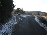
From the motorway Ljubljana - Koper take the exit Senožeče. After leaving the motorway, at the first junction, turn left towards Senožeče. In Senožeče, turn right towards Divača and follow the road until the road to the village of Gabrče turns left. Follow this road through the village and park in a small parking lot in the immediate vicinity of a small crossroads located behind the village.
Path description:
From the parking lot, continue along the worse (marked) road on the left, which after a few minutes' walk begins to climb moderately. After a short climb, you join another wide dirt road, which you follow to the left. This road quickly leads to a crossroads, where you will see the first signposts. Here, continue left up the road, which soon leads you out of the wods and onto the slopes. At a height of 800 m, near the mountain signposts, leave the road and turn right onto a footpath which crosses a short lane pine forest. The path then passes onto the extensive grassy slopes of Vremščica, which offer beautiful views. The trail continues on, occasionally crossing a short lane of forest, but quickly leaving it. The path, which ascends only gently, is mostly followed in a south-easterly direction. After a while, the path from Škocjanski jame joins us from the right and the path from Senožeč joins us from the left just a little further on. After both crossroads, the path climbs for a short time and after 15 minutes of climbing up the ridge leads us to the top of Vremščice.

Pictures:
 1
1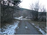 2
2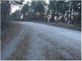 3
3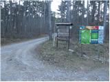 4
4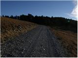 5
5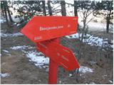 6
6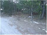 7
7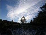 8
8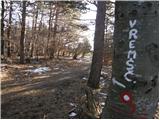 9
9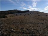 10
10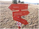 11
11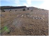 12
12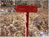 13
13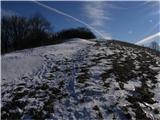 14
14 15
15
Discussion about the trail Gabrče - Vremščica
|
| Benč17. 02. 2008 |
Lep nenaporen nedeljski sprehod kljub malenkost vetrovnemu vremenu. Spomladi pa spet gor, ko bo vse cvetelo 
|
|
|
|
| Biser gora28. 02. 2008 |
Samo pazi, da ne boš izbral vetrovnega vremena. Ko smo bili lani na Vremščici. nas je od močne burje skoraj odpihnilo.
|
|
|
|
| sijoze7. 12. 2008 |
Zelo lep nedeljski izlet. Vremščica je danes ponujala fantastičen razgled. Nizek hrib pa smo videli pol Slovenije ali pač še kaj zraven. Smo pa šli naprej od tabel po cesti mimo ovčje farme dokler nismo prišli do poti, ki je prišla od Škocjanskih jam in gre levo v hrib (malo pozornosti). Na višino 800m se priključi poti ki pride po cesti. Ostalo je isto.
|
|
|
|
| frankosusa16. 10. 2011 |
 tej glupi tipi so oznacli da je na koncu gabrč parikirišč
|
|
|
|
| B21. 11. 2011 |
Pot (markirana), je del VIA ALPINE in sicer Senožeče - Škocjanske jame. Parkirišče v vasi Gabrče, je označeno še iz časov, ko je tu obratovala gostilna... Namesto v Gabrčah lahko parkiramo tudi na križišču makadamskih cest Senožeče - Vreme pri odcepu za Vremščico (slika 3 in 4). Do tam pridemo, če se po glavni cesti od Gabrč naprej peljemo še 500m, kjer je v levo dobro označen odcep makadamske ceste. Od tu gremo po nemarkirani, makadamski cesti levo navkreber in v dobrih 40 minutah pridemo na razgledno čistino, kjer se nam iz desne priključi SPP iz Škocjanskih jam (slika 6). Pri tablicah gremo desno in naprej proti vrhu, kot je v opisu.
|
|
|
|
| natasja27. 03. 2017 |
Na mestu, ki ga prikazuje slika 4 lahko nastane nekaj zmede, namreč markacije nas usmerijo naravnost po makedamski cesti mimo ovčje farme in kmalu markacij zmanjka.
Namesto naravnost se, kot je zapisano v navodilih, usmerimo na pot, ki pelje levo od tabel (na mestu, kjer je leva tabla je sedaj smerokaz za Veterinarsko fakulteto in okrepčevalnico), kjer pa do mesta, ki ga prikazuje slika 6 ni markacij.
|
|
|
|
| B218. 06. 2017 |
Kot sem že napisal leta 2011, je opis planinske poti Gabrče - Vremščica popolnoma napačen. Iz vasi Gabrče na Vremščico ni direktne markirane poti!
Če že hočemo startati v vasi Gabrče, gremo po markiranem kolovozu do mesta na sliki 4 (križišče cest, kraj se imenuje "Na gavgah", tam stojijo tudi planinski smerokazi, nobeden pa ne kaže smeri dostopa na Vremščico) in potem levo po makadamski cesti navkreber (markacij od tu ni, ker to ni planinska pot)dokler po kakih 40 minutah ne pridemo do mesta, ki je na sliki 6 in od tu dalje po markirani planinski poti na vrh.
|
|
|