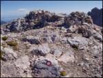
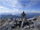
 | Pri Mlinču - Mangart (italijanska pot)
Mangart (also Mangrt, both spellings are grammatically correct) is a mountain that receives a very high number of visitors in summer. Access to t...
4 h 45 min |
 | Aljažev dom v Vratih - Dolkova špica (western way)
Dolkova špica is a 2591 m high mountain located between Stenar and Škrlatica. From the summit, where the registration box is located, you can enj...
5 h 15 min |
 | Vršič - Prisank / Prisojnik (Slovenian way)
Prisank is a 2547 m high mountain located above the valleys of Mlinarica, Krnica and Suha Pišnica. From the top of the peak, where the registrati...
3 h 30 min |
| Erjavčeva koča na Vršiču - Prisank / Prisojnik (Slovenska pot)
Prisank is a 2547 m high mountain located above the valleys of Mlinarica, Krnica and Suha Pišnica. From the top of the peak, where the registrati...
3 h 45 min |
 | The Kot Valley - Rjavina (ridge way)
Rjavina is located between two Alpine valleys. The two valleys are Kot and Krma. From the summit, which has a registration book, there is a very ...
6 h |
| Aljažev dom v Vratih - Rjavina (via Prag)
Rjavina is located between two Alpine valleys. The two valleys are Kot and Krma. From the summit, which has a registration book, there is a very ...
6 h 30 min |
 | Gozdec - Prestreljenik (via dom Petra Skalarja)
Prestreljenik is a 2499 m high mountain located in the heart of the Kanin Mountains. From the top, where the Aljaž Tower-shaped registration box ...
5 h 45 min |
| B station - Prestreljenik (via Krnica)
Prestreljenik is a 2499 m high mountain located in the heart of the Kanin Mountains. From the top, where the Aljaž Tower-shaped registration box ...
4 h 25 min |
| Sella Nevea - Prestreljenik (via Rifugio Gilberti)
Prestreljenik is a 2499 m high mountain located in the heart of the Kanin Mountains. From the top, where the Aljaž Tower-shaped registration box ...
4 h 15 min |
| Sella Nevea - Prestreljenik (via 636)
Prestreljenik is a 2499 m high mountain located in the heart of the Kanin Mountains. From the top, where the Aljaž Tower-shaped registration box ...
3 h 45 min |
 | Ruski križ - Špik (via Kačji graben)
Špik is a 2,472 m high mountain located in the heart of the Martuljek Mountains. From the top, which is clearly visible from the road leading thr...
4 h 50 min |
 | Aljažev dom v Vratih - Begunjski vrh (via Prag)
Begunjski vrh is a 2461 m high mountain located in the heart of the highest mountains in the Julian Alps. From the top, which has a registration ...
5 h |
 | Bodenbauer - Hochstuhl/Stol
At 2236 m, Stol is the highest peak in the Karavanke Mountains. From the summit, which has a registration box and a stamp, we have a beautiful vi...
4 h 30 min |
 | Bodenbauer - Vertatscha/Vrtača
Vertatscha is a 2181 m high peak located to the east of Stol. From the top of the peak, on which stands a large wedge, we have a beautiful view o...
4 h 45 min |
 | Koča pod slapom Rinka - Planjava
Planjava is a small mountain range to the east of Kamnik saddle. It has two peaks, one eastern and one western. There is a marked trail to the ea...
4 h 45 min |
| Planina Podvežak - Planjava (via Srebrno sedlo)
Planjava is a small mountain range to the east of Kamnik saddle. It has two peaks, one eastern and one western. There is a marked trail to the ea...
4 h 15 min |
 | Planina Podvežak - Planjava (via Škarje)
Planjava is a small mountain range to the east of Kamnik saddle. It has two peaks, one eastern and one western. There is a marked trail to the ea...
4 h 45 min |
| Planina Ravne - Planjava (via Dolga trata and Srebrno sedlo)
Planjava is a small mountain range to the east of Kamnik saddle. It has two peaks, one eastern and one western. There is a marked trail to the ea...
5 h 30 min |
| Planina Ravne - Planjava (via Dolga trata and Škarje)
Planjava is a small mountain range to the east of Kamnik saddle. It has two peaks, one eastern and one western. There is a marked trail to the ea...
6 h |
 | Kraljev dol - Planjava (via Srebrno sedlo)
Planjava is a small mountain range to the east of Kamnik saddle. It has two peaks, one eastern and one western. There is a marked trail to the ea...
4 h 30 min |
 | Tržiški graben - Storžič (via Javorniški preval)
Storžič is a 2132 m high mountain located in the western part of the Kamink Savinja Alps. From the top with a cross there are beautiful views of ...
3 h 40 min |
 | Koča pod slapom Rinka - Brana
Brana is a mountain above Kamnik saddle. The view from the spacious summit, which has a registration box and a small cross, is very beautiful. Pl...
3 h 45 min |
 | Erjavčev rovt - Mittagskogel/Kepa
Kepa, also Jepa, or Mittagskogel in German, is a scenic mountain in the western Karawanks, located on the border ridge between Slovenia and Austr...
3 h 50 min |
| Ravne - Mittagskogel/Kepa
Kepa, also Jepa, or Mittagskogel in German, is a scenic mountain in the western Karawanks, located on the border ridge between Slovenia and Austr...
4 h 15 min |
 | Planina Podvežak - Ojstrica (via Kocbekov dom)
Ojstrica, named after its sharp shape, rises steeply above the Korošica River, the Logar Valley and Robanov Kot. From the top, where the registra...
4 h |
 | Planina Ravne - Ojstrica (via Mala Ojstrica)
Ojstrica, named after its sharp shape, rises steeply above the Korošica River, the Logar Valley and Robanov Kot. From the top, where the registra...
4 h 15 min |
| Planina Ravne - Ojstrica (via Dolga trata and Kocbekov dom)
Ojstrica, named after its sharp shape, rises steeply above the Korošica River, the Logar Valley and Robanov Kot. From the top, where the registra...
5 h 15 min |
| Planina Ravne - Ojstrica (via Dolga trata and Mala Ojstrica)
Ojstrica, named after its sharp shape, rises steeply above the Korošica River, the Logar Valley and Robanov Kot. From the top, where the registra...
4 h 45 min |
| Kraljev dol - Ojstrica (via Mala Ojstrica)
Ojstrica, named after its sharp shape, rises steeply above the Korošica River, the Logar Valley and Robanov Kot. From the top, where the registra...
3 h 45 min |
| Kraljev dol - Ojstrica (via Kocbekov dom)
Ojstrica, named after its sharp shape, rises steeply above the Korošica River, the Logar Valley and Robanov Kot. From the top, where the registra...
4 h 15 min |
 | The Kot Valley - Cmir
The mountain is located between two Alpine valleys between Vrata and the lesser-known Za Cmirom valley. From the top you can enjoy a beautiful vi...
6 h |
| Aljažev dom v Vratih - Cmir (via Prag)
The mountain is located between two Alpine valleys between Vrata and the lesser-known Za Cmirom valley. From the top you can enjoy a beautiful vi...
6 h 30 min |
 | Aljažev dom v Vratih - Križ (via Sovatna)
Križ is a 2140 m high mountain located north-east of the Kriški Podi. From the top, where there is a registration box with a stamp, you have a be...
5 h |
 | Podnar / Bodenbauer - Prešernova koča na Stolu
Prešernova koča na Stolu, is located just a few metres below the summit of the 2198 m high Mali Stol. From the hut or the nearby Mali Stol, we ha...
4 h 25 min |
 | Kriška planina - Kalški greben (via Zvoh)
Kalški greben is 2224 m high and is the highest peak of the eponymous ridge. The summit, which has a registration box and a stamp, offers a beaut...
4 h 10 min |
| Dom na Gospincu - Kalški greben (via Zvoh)
Kalški greben is 2224 m high and is the highest peak of the eponymous ridge. The summit, which has a registration box and a stamp, offers a beaut...
4 h 10 min |
| Planina Jezerca - Kalški greben (via Dom na Krvavcu and Zvoh)
Kalški greben is 2224 m high and is the highest peak of the eponymous ridge. The summit, which has a registration box and a stamp, offers a beaut...
4 h 25 min |
 | Aljažev dom v Vratih - Visoka Vrbanova špica (via Prag)
Visoka Vrbanova špica, is located at the extreme south-western part of the ridge rising above the Kot and Vrata valleys, and higher up between th...
4 h 50 min |
 | Aljažev dom v Vratih - Planja (via Sovatna)
The summit is located between two Alpine valleys. On the northern side is the Mlinarica valley and on the southern side is the Zadnjica valley. F...
6 h 15 min |
| Vršič - Planja
The summit is located between two Alpine valleys. On the northern side is the Mlinarica valley and on the southern side is the Zadnjica valley. F...
5 h 45 min |
 | Planina Blato - Veliko Špičje (via Štapce)
Veliko Špičje is the highest peak in the ridge from Travnik to Zasavska hut. From the top there is a very nice view over the plateaus of Komna, t...
5 h 45 min |
 | Aljažev dom v Vratih - Bovški Gamsovec (via Luknja)
Bovški Gamsovec is a 2392m high mountain in the immediate vicinity of Triglava. From the top, you can enjoy a magnificent view of Triglav and its...
4 h 30 min |
| Aljažev dom v Vratih - Bovški Gamsovec (via Sovatna)
Bovški Gamsovec is a 2392m high mountain in the immediate vicinity of Triglava. From the top, you can enjoy a magnificent view of Triglav and its...
4 h 45 min |
 | Plockenpass - Monte Coglians (Hohe Warte) (via Rifugio Marinelli)
At 2780 metres, Monte Coglians is the highest mountain in the Carnic Alps. From the top, where the cross and the bell stand, you have a very nice...
5 h |
| Rifugio Tolazzi - Monte Coglians (Hohe Warte) (via Rifugio Marinelli)
At 2780 metres, Monte Coglians is the highest mountain in the Carnic Alps. From the top, where the cross and the bell stand, you have a very nice...
4 h 25 min |
 | Ravenska Kočna - Velika (Koroška) Baba (via Jenkova planina)
Velika is a 2127 m high mountain on the border ridge above the Ravenská Kočna valley on the Slovenian side and above the Bela valley (Belska Kočn...
3 h 30 min |
 | Sella Nevea - Velika Črnelska špica (on ski track)
Velika Črnelska špica is located in the Kanin Mountains on the border between Itali and Slovenia. From the top, you can enjoy a very nice view of...
4 h 30 min |
| Sella Nevea - Velika Črnelska špica (via 636)
Velika Črnelska špica is located in the Kanin Mountains on the border between Itali and Slovenia. From the top, you can enjoy a very nice view of...
4 h 45 min |
 | Goldberg - Torkofel
Torkofel is the highest peak of the Jauken lookout ridge, which stretches north of the Ziljska valley. From the top with a cross there is a beaut...
3 h 45 min |
 | Reißkofelbad - Reißkofel (via east ridge)
Reißkofel is a 2371 metre high mountain in the Zilj Alps. The summit on which the cross stands also has a registration box. The view from the top...
4 h 45 min |
 | Reißkofelbad - Kleiner Reißkofel
Kleiner Reißkofel is a 2161 metre high mountain east of Reißkofl. From the summit on which the cross stands, you can enjoy a beautiful view of th...
3 h 30 min |
 | Göriach - Scharnock
Scharnock is a scenic peak located in the Schladminger Tauern mountain group. From the summit on which the cross stands, there is a beautiful vie...
3 h 30 min |
 | Göriach - Hochgolling (Normalanstieg)
Hochgolling is a 2863m high peak, according to some data 2862m high, located in the heart of the Schladminger Taueren group. Hochgolling is also ...
4 h |
 | Sella Nevea - Viš/Jof Fuart
Viš is a 2666m high peak in the western Julian Alps. From the top, where the statue of St Mary and the cross stand, you can enjoy a beautiful vie...
5 h |
| Cave del Mole - Viš/Jof Fuart
Viš is a 2666m high peak in the western Julian Alps. From the top, where the statue of St Mary and the cross stand, you can enjoy a beautiful vie...
4 h 30 min |
 | Aljažev dom v Vratih - Pihavec (via Sovatna)
Pihavec is a vast and scenic peak located to the south of the Kriški Podovi. From the summit, which has a registration box and a stamp, there is ...
5 h |
 | Cave del Mole - Koštrunove špice (via Forcella Lavinal dell Orso)
Koštrunove špice is a 2502 m high peak located south-west of Viš (2666 m). The summit offers a beautiful view over most of the western Julian Alp...
4 h |
| Cave del Mole - Koštrunove špice (via Forcella Mose)
Koštrunove špice is a 2502 m high peak located south-west of Viš (2666 m). The summit offers a beautiful view over most of the western Julian Alp...
4 h |
| Sella Nevea - Koštrunove špice (via Forcella Lavinal dell Orso)
Koštrunove špice is a 2502 m high peak located south-west of Viš (2666 m). The summit offers a beautiful view over most of the western Julian Alp...
4 h 30 min |
 | Alba di Canazei - Cima Ombretta (via Passo Ombretta)
Cima Ombretta is a 3011-metre peak in the Marmolada mountain group. The summit on which the cross stands offers the best view of the nearby south...
5 h |
| Malga Ciapela - Cima Ombretta (via Passo Ombretta)
Cima Ombretta is a 3011-metre peak in the Marmolada mountain group. The summit on which the cross stands offers the best view of the nearby south...
4 h 40 min |
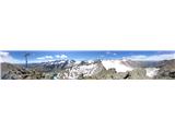
 | Erschbaum - Große Kinigat / Monte Cavallino (western way)
Große Kinigat is a 2,689 metre high peak in Carnic Alpsah. The peak is located in the western part of the Carnic Alps and is one of the few in th...
6 h |
 | Ristorante Pietofana - Cima Formenton
Cima Formenton is a 2830 m high peak in the Tofana mountain group. The mountain is located to the north of the better known Tofana di Dentro, and...
3 h 40 min |
 | Rifugio Pederü - Croda del Beco / Seekofel
Croda del Beco (German: Seekofel, Ladin: Sass dla Porta) is a 2,810-metre-high mountain rising steeply above Lago di Braies (Pragser Wildsee). It...
3 h 45 min |
| Rifugio Ra Stua - Croda del Beco / Seekofel
Croda del Beco (German: Seekofel, Ladin: Sass dla Porta) is a 2,810-metre-high mountain rising steeply above Lago di Braies (Pragser Wildsee). It...
3 h 35 min |
 | Plockenpass - Cima di Mezzo / Keller Warte (via Rifugio Marinelli)
The Cima di Mezzo (German: Keller Warte) is a 2713-metre-high mountain in Carnic Alps on the border between Austria and Itali. There is a small c...
4 h 35 min |
| Rifugio Tolazzi - Cima di Mezzo / Keller Warte (via Rifugio Marinelli)
The Cima di Mezzo (German: Keller Warte) is a 2713-metre-high mountain in Carnic Alps on the border between Austria and Itali. There is a small c...
4 h |
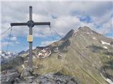
 | Bergheimat - Dachskofel (via Scharnik)
Dachskofel is a 2373m high mountain in Hohe Tauern in Austria above the city of Irschen and near the Lamnitzsee. A wooden cross is placed on the ...
3 h 50 min |
 | Weißenbach - Spitzegel / Negal (via Bodenalm)
Spitzegel or. Negal (in Slovene) is a 2119 m high mountain in Gailtal Alps in Austria.The narrow ridge is a logical continuation of Dobrač / Dobr...
4 h 30 min |
 | Passo di Sant'Antonio - Monte Aiarnola (via normale)
Monte Aiarnola is a mountain in the easternmost part of the Sexten Dolomites group. It offers a fine view of the western Carnic Alps, the Marmaro...
3 h 30 min |
 | Cima Sappada - Creton di Tul
Creton di Tul is a 2288 meter high mountain in a mountain group Pesarina Dolomites in the Carnic Alps in Italy, south of a city of Sappada and ju...
3 h 30 min |
 | Cima Sappada - Creta Forata
Creta Forata is a 2462 meter high mountain in a mountain group of the Pesarina Dolomites in the Carnic Alps in Italy, south of a city of Sappada....
4 h |
 | Oberissalm - Rinnenspitze (običajni pristop mimo Franz-Senn-Hütte)
Rinnerspitze is a beautiful conical mountain rising above the lake of the same name. Although it does not stand out for its height or the difficu...
3 h 45 min |
 | Gschnitz - Kalkwand (zahodni pristop iz Gschnitza preko Pinnisjocha)
Kalkwand is a large mountain in the eastern part of the Habicht group of the central Stubai Alps. Thanks to its attractive views, the low difficu...
3 h 45 min |