 | Topol - Sveti Jakob
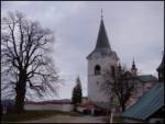
The Church of St. James is located on a scenic hill north of the village of Topol pri Medvodah. From the summit, which features a registration bo...
40 min |
| Topol - Sveti Jakob (via homestead Na Vihri)
The Church of St. James is located on a scenic hill north of the village of Topol pri Medvodah. From the summit, which features a registration bo...
45 min |
 | Javornik - Sveti Jošt above Kranj
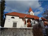
Sveti Jošt above Kranj is a hill located west of the slightly lower Šmarjetna gora. From the summit, where the Church of St Jošt stands alongside...
40 min |
| Čepulje - Sveti Jošt above Kranj
Sveti Jošt above Kranj is a hill located west of the slightly lower Šmarjetna gora. From the summit, where the Church of St Jošt stands alongside...
45 min |
 | Dom na Govejku - Osolnik
Osolnik is an 858-metre-high mountain located south of Škofja Loka and west of Medvode. From the summit, where the Church of St Mohor and Fortuna...
1 h |
 | Rovišče - Zasavska Sveta gora (by road)
Zasavska Sveta Gora is a popular excursion destination located between Litija and Izlake. From the summit, where the parish church of the Nativit...
35 min |
 | Topol - Jeterbenk
Jeterbenk is a 774-meter-high peak located between the Slavkov dom hut on Golo Brdo and Katarina (the village of Topol). From the summit, where t...
45 min |
 | Praproče - Mali vrh
West of Polhov Gradec, between the rivers Mala voda and Velika Božna, lies the 708-meter-high hill known as Mali vrh. From the grassy summit, whi...
35 min |
 | Križna Gora - Archangel Gabriel (Planica)
Planica is an 824-meter-high peak located north of Škofja Loka, more precisely between Križna gora and Planica. From the summit, where the church...
35 min |
 | Čepulje - Archangel Gabriel (Planica)
Planica is an 824-meter-high peak located north of Škofja Loka, more precisely between Križna gora and Planica. From the summit, where the church...
50 min |
 | Smrečje - Vrh Svetih Treh Kraljev (by road)
The Church of the Holy Three Kings stands on a panoramic hill above the village of Vrh Svetih Treh Kraljev. The summit features a panorama board ...
45 min |
 | Smrečje - Vrh Svetih Treh Kraljev (footpath)
The Church of the Holy Three Kings stands on a panoramic hill above the village of Vrh Svetih Treh Kraljev. The summit features a panorama board ...
40 min |
| Smrečje - Vrh Svetih Treh Kraljev (via Jereb)
The Church of the Holy Three Kings stands on a panoramic hill above the village of Vrh Svetih Treh Kraljev. The summit features a panorama board ...
45 min |
| Račevsko jezero - Vrh Svetih Treh Kraljev
The Church of the Holy Three Kings stands on a panoramic hill above the village of Vrh Svetih Treh Kraljev. The summit features a panorama board ...
45 min |
 | Sveta Gora - Vodice
Vodice (according to some records also Sveti Jakob) is a peak on the western part of the Banjška planota plateau. From the summit, which features...
45 min |
 | Tržič - Sveti Jurij above Tržič
The Church of St. Jurij, built in the 15th century, stands on a small hill above Tržič or Bistrica pri Tržiču. Nearby Gutenberg Castle, to which ...
40 min |
 | Grozzana / Gročana - Kokoš
The Koča na Kokoši mountain hut is located on Jirmanec peak, just 5 minutes from the forested Kokoš. From the summit, situated south of Lokavsko ...
40 min |
 | Blečji vrh - Kucelj
Kucelj is a 748-meter-high peak situated north of Višnja gora. From the summit, where there is a small geodetic tower with a nearby stamp, there ...
45 min |
| Veliko Trebeljevo - Kucelj
Kucelj is a 748-meter-high peak situated north of Višnja gora. From the summit, where there is a small geodetic tower with a nearby stamp, there ...
45 min |
 | Leskovec - Obolno
Obolno is a 776-meter-high peak located southwest of the eponymous village. From the grassy summit, by which a radio club hut stands, there is a ...
1 h |
 | Velika vrata - Mala Plešivica
Mala Plešivica, higher than neighboring Velika Plešivica, is a panoramic peak located west of the village Golac near the Croatian border. On clea...
35 min |
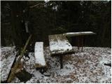
 | Križevska vas - Murovica (circular path)
Murovica is a popular excursion point, accessible from the Posavje side, Domžale, or the Moravška Valley. On the summit there is a bench and a lo...
50 min |
 | Križevska vas - Murovica
Murovica is a popular excursion point, accessible from the Posavje side, Domžale, or the Moravška Valley. On the summit there is a bench and a lo...
45 min |
 | Velika Zaka (Bled) - Mala Osojnica (along Ojstrica)
Mala Osojnica is a 691-meter-high peak rising above Lake Bled near Velika Zaka. It is considered the most popular spot for photographers, as all ...
40 min |
 | Smrečje - Lavrovec
Lavrovec is an 890-meter-high peak located between Horjul and Žiri. From the summit, which hosts a solar irradiance meter (official measuring poi...
40 min |
 | Dom na Govejku - Gontarska planina
Gontarska Planina is a 894-meter-high hill located between Osolnik and Tošč. From the summit, which features two benches, a splendid view opens t...
35 min |
 | Belo - Goljek
Goljek is an 809 m high peak located east of Polhograjska Grmada. From the summit, where remains of a former guard tower on the Italian-German bo...
40 min |
 | Čepulje - Špičasti hrib
Špičasti hrib (known as Špičasti vrh on maps) is an 837-meter-high hill located west of Sveti Jošt above Kranj. The summit, which has a few bench...
40 min |
 | Otlica - Dolski maj
Dolski maj (also Predmejski maj) is a 912-meter-high peak located on the edge of Gora, more precisely between Predmeja and Otlica. From the summi...
1 h |
 | Mrše - Sveti Socerb (Artviže)
The Church of St. Socerb is located on a panoramic hill above the village of Artviže, which at 817 meters is the highest peak of the Brkini. From...
1 h |
 | Podlanišče - Veliki vrh (Lajše)
Veliki vrh is an almost 900-meter-high elevation rising south of Cerkno. From the summit, which features several television and radio transmitter...
40 min |
 | Hunting sports association Vinska Gora - Vinska gora
Vinska gora (marked as the neighboring Temnjak on some maps) is an 806 m high hill located northwest of Dobrna and northeast of Vinska Gora. From...
40 min |
 | Planinski dom pod Ježo - Deveti konfin (survey point 930)
Deveti konfin at survey point 930 is located along the marked path leading from Planinski dom pod Ježo towards Očna. From the meadow a few meters...
55 min |
 | Planinski dom pod Ježo - Deveti konfin (survey point 942)
Deveti konfin at survey point 942 is one of two peaks of Deveti konfin in the Kolovrat range, located between Ježa and Očna. From the summit, whe...
45 min |
 | Srednje - Globočak
Globočak is an 809 m high peak located in the Kanal Kolovrat range. From the summit, which has some remnants from the First World War, there is n...
35 min |
 | Zagorje - Šilentabor
Šilentabor is a 751-meter-high peak just above the village of the same name. From the summit, near which there is a bench and a logbook box, ther...
35 min |
 | Črne njive - Ahac
Ahac (or Sv. Ahac) is a 799-meter-high peak located east of Ilirska Bistrica. The summit hosts a summit logbox, a cross, and ruins of the former ...
40 min |
 | Vrbiški dol - Ahac
Ahac (or Sv. Ahac) is a 799-meter-high peak located east of Ilirska Bistrica. The summit hosts a summit logbox, a cross, and ruins of the former ...
1 h |
 | Dragonoš (Krpesovka) - Japetić
Japetić is the highest peak of the Samoborsko gorje. It is located in its western part and serves as the local mountain for the town of Jastrebar...
45 min |
 | Veliko Trebeljevo - Sveta Marjeta (Prežganje)
The Church of St. Marjeta stands on the hilltop above Prežganje. Next to the church is the Minorite retreat house, and a bit lower down the Marje...
40 min |
 | Travnarjev gozd (Hotenjsko podolje) - Sveta Barbara (Ravnik pri Hotedršici)
The Church of St. Barbara is located on a panoramic rise above the settlement of Ravnik pri Hotedršici. From the church or its immediate surround...
35 min |
 | Možjanca - Apnišče
Apnišče is a 740 m high mountain between Možjanca and Štefanja gora. It is the highest point of the Šenčur municipality. The forested summit offe...
35 min |
 | Ledinsko Razpotje - Sveta Marija Magdalena (Gore) (east path)
The Church of St. Mary Magdalene is located on a hill above the settlement of Gore, which lies above Idrija. From the church or its immediate sur...
1 h |
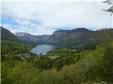 | Jezersko polje - Peč (viewpoint)
The viewpoint is located about 50 vertical meters below the 720-meter-high Peč peak, which separates the Lower from the Upper Bohinj Valley on th...
35 min |
 | Škalske Cirkovce - Skalni vrh (Vodemla)
Skalni vrh is the highest summit of the hill Vodemla, which rises on one side above Paka pri Velenju and on the other above the Velenje Basin. Al...
35 min |
 | Škalske Cirkovce - Lubela (by road)
Lubela is a hill near Velenje that rises to the north above the Šaleška Valley and belongs to the Šentviško Hills or the broader Graška Gora area...
45 min |
 | Zajasovnik - del (Strmce, chapel) - Jasovnik (Motnik tourist trail)
Jasovnik is a hill better known to everyone as the A1 highway tunnel. It lies near Trojane and has two peaks: Mali Jasovnik and Jasovnik. The sum...
45 min |
| Stružnica - Kuželjska stena
Kuželjska stena rises mightily above the village of Kuželj in the Kolpa River valley. It is a hill at a slope break, winding above the upper Kolp...
45 min |
 | Smiljan - Krčmar (on marked path)
Krčmar is a 773-meter-high peak above Smiljan, known for the Nikola Tesla Memorial Center. There is a cross and an HPO stamp on the summit, which...
40 min |
 | Rašpor - Gradina Rašpor (on marked path)
Gradina Rašpor are the ruins of a former castle above the village of Rašpor. Several information boards are by the ruins. Due to the surrounding ...
45 min |
 | Rašpor - Marećica
Marećica is a lesser-known peak located above Buzet. The peak marks a point on the Obiteljska staza Marećica trail. From the summit, there is a b...
1 h |