Starting point: Topol (700 m)
| Latitude/Longitude: | 46,0937°N 14,3695°E |
| |
Walking time: 45 min
Difficulty: easy marked way
Elevation gain: 74 m
Elevation difference along the route: 130 m
Map: Ljubljana-Okolica 1:50.000
Recommended equipment (summer):
Recommended equipment (winter):
Views: 20.371
 | 5 people like this post |
Access to starting point:
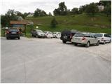
From Medvode we drive to the village Sora, where we head towards the village Topol (Katarina). When the road brings us to the mentioned village we park on a large parking lot.
From Dobrova we drive ahead towards Polhov Gradec. When the signpost for the village Topol points us to the right we turn onto this road and follow it to the crossroads in the village Topol. We continue towards the village Sora, but only to the parking lot, which we see on the right side of the road.
Route description:
From the parking lot, we ascend a few dozen steps on an asphalt road to a crossroads where we notice numerous signposts. We continue left in the direction of St. Katarina, St. Jakob and Jeterbenk. The relatively steep asphalt road brings us, after a few minutes of walking, to a poorly marked crossroads at the chapel, where we continue right towards St. Katarina and Jeterbenk (left St. Jakob). The path then past numerous hiking signs brings us to the church of St. Katarina. We continue straight on a macadam road which starts descending and after a few minutes of additional walking brings us to a junction at the chapel.
We continue straight in the direction of Jeterbenk (left Žlebe, right Slavkov dom) on a wide path, which higher at the weekend cottage changes into a steep footpath, which brings us in about 5 minutes to the summit of Jeterbenk.
Along the route: Sveta Katarina (750m)
Photos:
 1
1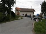 2
2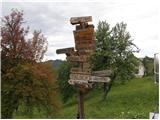 3
3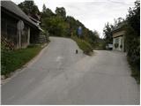 4
4 5
5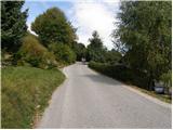 6
6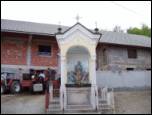 7
7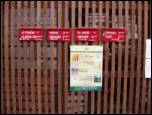 8
8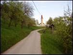 9
9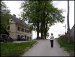 10
10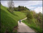 11
11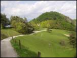 12
12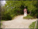 13
13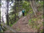 14
14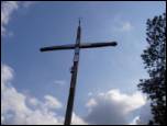 15
15
Discussion about the trip Topol - Jeterbenk
|
| fpetel122. 05. 2006 |
I went some time ago by bus to Medno, then to Slavkov dom, past the Petelinec little church to Jetrbenk. Then to the village Topol and into the valley and towards Vrhovcem. The above description and my excursion are the most beautiful in clear early spring days, when the snow melts. What remained in my memory is mainly the huge cross, beautiful view, and blooming hellebores.
|
|
|
|
| Gost22. 09. 2006 |
Yesterday my sister-in-law and I went from Preska, past Žleb and Sv. Marjeta, to Sv. Katarina, Jeterbenk to Slavkov dom and back to Preska. The views are wonderful! However, the path is VERY POORLY MARKED, in places the marks have faded or are completely missing, at junctions there are no indications either..which way!? We had to ask several times if we met someone, or turn back and go in the "right" direction.
Otherwise we will go to this area again! nice 
|
|
|
|
| Gost2. 11. 2006 |
About a month ago my sister-in-law and I went hiking... this time there were more of us (5)... we went from Sora to Sv. Jakob, to Križ nad Sv. Katarino, to Jeterbenk and to Slavkov dom and further to Preska, where we had the second car parked. This time the markings were clearly visible as they are newly made. All praise !!! Wonderful views Wonderful views 
|
|
|
|
| Gost14. 11. 2006 |
MT-Path from Slavkov dom via Petelinca and (where construction site is now) past the chapel (Podružnica sv. Jakob) along the ridge to the top is wonderful in these autumn days. Along the ridge somewhat steep and slippery in places due to leaves. Nice view from the top towards Julians and Karavanke, towards Ljubljana the viewpoint is unfortunately overgrown. Path time 1h30m to 2h.
|
|
|
|
| mili30. 03. 2012 |
Yesterday on the path a little below the summit I surprised two snakes mating. The logbook says they are two adders. Since there will be more visitors these days due to the flowering of blagajans, I warn hikers to be careful.
|
|
|
|
| Lunatic30. 03. 2012 |
There are always plenty of them on Jeterbenk, I put the dog on a leash and look twice where I sit down 
|
|
|
|
| KARAMELICA8. 02. 2015 |
We left the car at the playground in the village of Trnovec. We went to the village of Topol on asphalt, then past the church at Sv. Katarina and then to Jetrbenk. We returned the same way to the inn at Sv. Katarina but we didn't go back to the valley but past the inn at Sv. Katarina towards Polhograjska grmada and Tošča. But when we reached the foot of Polhograjska grmada we didn't go to the top but right to Gonte and then from there on asphalt to the valley. Great circular path, walk for good three hours. Wonderful day and also excellent pehtranova potica at Gontah. Yummy.
|
|
|
To post a comment you must log in:
If you do not yet have a username, you must first
register.