Škalske Cirkovce - Skalni vrh (Vodemla)
Starting point: Škalske Cirkovce (615 m)
| Latitude/Longitude: | 46,3955°N 15,1364°E |
| |
Walking time: 35 min
Difficulty: easy marked way
Elevation gain: 165 m
Elevation difference along the route: 206 m
Map: Šaleška dolina z okolico 1:50000
Recommended equipment (summer):
Recommended equipment (winter):
Views: 5.904
 | 2 people like this post |
Access to starting point:
From the Ljubljana - Maribor highway, take the Žalec exit, then continue driving in the direction of Velenje. In the main roundabout (2nd roundabout) in Velenje, below the ski jumping hill, continue straight (2nd exit) in the direction of Šoštanj - Mozirje. Then at the traffic-light intersection turn right. Drive straight, over the railway track, uphill to the next roundabout. Take the 3rd exit in the direction of the town stadium. The next roundabout follows, in which take the 1st exit in the direction of Škale - Graška gora.
Drive past Škale Lake to the settlement Škale. A crossroad follows, in which turn right towards Cirkovce. Drive through the settlement Hrastovec to Škalske Cirkovce. At the church of St. Ožbolt turn right and park by the sports field.
Route description:
From the parking lot at the sports field we go right by the branch school Cirkovce and descend on a narrower paved path to the road. A crossroad follows, at which we turn right.
The road rises to the saddle between Vodemla and Stropnica. Then follows a descent to a cross on the left side. We leave the asphalt road and turn right onto the forest road. We walk steeply upwards along the road. In between, a view opens up towards Velenje.
A smaller crossroad of forest paths follows. We turn left. On the nearby tree we see the inscription Skalni vrh. The path is well marked and brings us to the top in less than 10 minutes.
Photos:
 1
1 2
2 3
3 4
4 5
5 6
6 7
7 8
8 9
9 10
10 11
11 12
12 13
13 14
14 15
15 16
16 17
17 18
18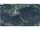 19
19
Discussion about the trip Škalske Cirkovce - Skalni vrh (Vodemla)
To post a comment you must log in:
If you do not yet have a username, you must first
register.