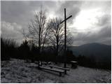
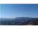
 | Topol - Sveti Jakob
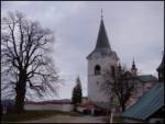
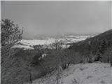
The Church of St. James is located on a scenic hill north of the village of Topol pri Medvodah. From the summit, which features a registration bo...
40 min |
| Topol - Sveti Jakob (via homestead Na Vihri)
The Church of St. James is located on a scenic hill north of the village of Topol pri Medvodah. From the summit, which features a registration bo...
45 min |
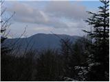
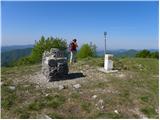
 | Tourist farm Gonte - Tošč
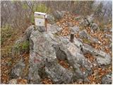
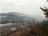
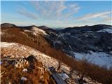
Tošč, which became the highest peak of the Polhov Gradec Hills decades ago when the Yugoslav army lowered Pasja ravan by 9 metres, is located nor...
45 min |
 | Zapotok - Kurešček
Kurešček is an 826 m high peak located south of Ig and southwest of Želimlje. From the summit, where a church stands, there is no view due to the...
45 min |
 | Javornik - Sveti Jošt above Kranj
Sveti Jošt above Kranj is a hill located west of the slightly lower Šmarjetna gora. From the summit, where the Church of St Jošt stands alongside...
40 min |
| Čepulje - Sveti Jošt above Kranj
Sveti Jošt above Kranj is a hill located west of the slightly lower Šmarjetna gora. From the summit, where the Church of St Jošt stands alongside...
45 min |
 | Rovišče - Zasavska Sveta gora (by road)
Zasavska Sveta Gora is a popular excursion destination located between Litija and Izlake. From the summit, where the parish church of the Nativit...
35 min |
 | Križna Gora - Archangel Gabriel (Planica)
Planica is an 824-meter-high peak located north of Škofja Loka, more precisely between Križna gora and Planica. From the summit, where the church...
35 min |
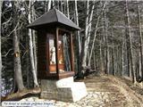
 | Smrečje - Vrh Svetih Treh Kraljev (by road)
The Church of the Holy Three Kings stands on a panoramic hill above the village of Vrh Svetih Treh Kraljev. The summit features a panorama board ...
45 min |
 | Smrečje - Vrh Svetih Treh Kraljev (footpath)
The Church of the Holy Three Kings stands on a panoramic hill above the village of Vrh Svetih Treh Kraljev. The summit features a panorama board ...
40 min |
| Smrečje - Vrh Svetih Treh Kraljev (via Jereb)
The Church of the Holy Three Kings stands on a panoramic hill above the village of Vrh Svetih Treh Kraljev. The summit features a panorama board ...
45 min |
| Račevsko jezero - Vrh Svetih Treh Kraljev
The Church of the Holy Three Kings stands on a panoramic hill above the village of Vrh Svetih Treh Kraljev. The summit features a panorama board ...
45 min |
 | Lanišče - Janče
Janče is a 792-meter-high peak situated between the Sava River and the Besnica stream valley. From the summit, where a mountain hut stands and th...
30 min |
 | Dom na Paškem Kozjaku - Špik (Paški Kozjak)
Špik is the easternmost peak of the relatively long ridge of Paški Kozjak. From the summit, which has a summit register, the view is only towards...
30 min |
 | Ledine - Sivka
Sivka is a forested peak located west of Žiri and north of Idrija. At the summit there is a stamp for the Slovenian Mountain Trail and a logbook ...
45 min |
 | Hunting cottage Prehod - Jelenk
Jelenk is a mountain between the valley of the Idrijca River, above which it rises steeply, and the valley of the Kanomljica River. From the summ...
30 min |
 | Travna Gora - Koča na Kamnem griču
The Koča na Kamnem griču mountain hut is located on Kamni grič, a panoramic hill rising southwest of Sodražica. From the grassy summit surrounded...
45 min |
 | Retjiški gozd - Koča na Kamnem griču
The Koča na Kamnem griču mountain hut is located on Kamni grič, a panoramic hill rising southwest of Sodražica. From the grassy summit surrounded...
25 min |
 | Lom - Koča na Kamnem griču
The Koča na Kamnem griču mountain hut is located on Kamni grič, a panoramic hill rising southwest of Sodražica. From the grassy summit surrounded...
45 min |
 | Hunting cottage Urška - Racna gora
Racna gora is a little-visited peak rising east of Loška dolina. From the summit, which has a logbook box and stamp, there is no view due to the ...
45 min |
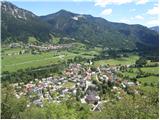
 | Križna jama - Križna gora
Križna gora is a partly panoramic peak located above the villages of Sveta Ana and Podlož. From the summit, where the Church of the Holy Cross st...
35 min |
 | Dule - Kamen vrh
Kamen Vrh is a panoramic hill located on the northern edge of Mala Gora. From the summit, surrounded by low bushes, there are fine views of parts...
45 min |
 | Ortnek - Ortnek Castle
Ortneški Stari Grad is located on the Veliki Žrnovec hill, which rises southwest of the village of Ortnek. Of the castle, built in the 12th centu...
40 min |
 | Jesenice (Ukova) - Kalvarija above Jesenice
Kalvarija is a popular point or peak above the town of Jesenice, known either as a sort of short "pilgrimage" path for the faithful or as a desti...
25 min |
 | Mislinja - Črepič
Črepič is an 798-meter-high peak west of Mislinja. The summit is forested and offers no view, but there is an expansive panorama from a nearby me...
45 min |
 | Begunje - Goli vrh (Cemarovnik)
Goli vrh, also known as Begunjski Cemarovnik, is an 816 m high mountain located on the southeastern part of Menišija. From the summit, where a la...
30 min |
 | Planinski dom Vrhe - Sveta planina (Partizanski vrh)
Sveta planina, also Partizanski vrh, is a 1,011-meter-high mountain located between Čemšeniška planina and Mrzlica. From the summit, where there ...
35 min |
 | Kamen - Mokrc
Mokrc (Mokrec on maps) is a 1,059-meter-high mountain located east of Iški Vintgar. The summit is forested and offers no views.For some views, it...
40 min |
 | Smrečje - Lavrovec
Lavrovec is an 890-meter-high peak located between Horjul and Žiri. From the summit, which hosts a solar irradiance meter (official measuring poi...
40 min |
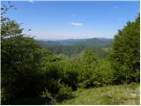
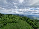
 | Dom na Govejku - Gontarska planina
Gontarska Planina is a 894-meter-high hill located between Osolnik and Tošč. From the summit, which features two benches, a splendid view opens t...
35 min |
 | Belo - Goljek
Goljek is an 809 m high peak located east of Polhograjska Grmada. From the summit, where remains of a former guard tower on the Italian-German bo...
40 min |
| Topol - Goljek (on west ridge)
Goljek is an 809 m high peak located east of Polhograjska Grmada. From the summit, where remains of a former guard tower on the Italian-German bo...
30 min |
 | Rakitna - Rotovc
Rotovc is a 964-meter-high peak situated northeast of Rakitna. From the summit, where a wooden bench stands, a beautiful view opens up toward the...
30 min |
 | Trebež (Jesenice) - Kozjek (on east ridge)
Kozjek is a 766 m high, easily accessible ridge-like secondary peak of Jelenkamen, belonging to the southern Karawanks foothills; it is located a...
30 min |
 | Čepulje - Špičasti hrib
Špičasti hrib (known as Špičasti vrh on maps) is an 837-meter-high hill located west of Sveti Jošt above Kranj. The summit, which has a few bench...
40 min |
 | Podlanišče - Veliki vrh (Lajše)
Veliki vrh is an almost 900-meter-high elevation rising south of Cerkno. From the summit, which features several television and radio transmitter...
40 min |
 | Hunting sports association Vinska Gora - Temnjak
Temnjak (on some maps also written as Vinska gora, the neighboring hill) is a 798 m high peak located north of the village of Prelska pri Vinski ...
25 min |
 | Hunting sports association Vinska Gora - Vinska gora
Vinska gora (marked as the neighboring Temnjak on some maps) is an 806 m high hill located northwest of Dobrna and northeast of Vinska Gora. From...
40 min |
 | Planinski dom pod Ježo - Ježa
Ježa is a 949-meter-high peak located west of Volče, more precisely on the slopes of Kolovrat. From the summit, which has a logbook box with a bo...
30 min |
 | Planinski dom pod Ježo - Deveti konfin (survey point 942)
Deveti konfin at survey point 942 is one of two peaks of Deveti konfin in the Kolovrat range, located between Ježa and Očna. From the summit, whe...
45 min |
 | Solarji - Na gradu
Na gradu is a 1115 m high peak located in the middle of the Kolovrat range, precisely on the border between Slovenia and Italy. From the grassy s...
30 min |
 | Srednje - Globočak
Globočak is an 809 m high peak located in the Kanal Kolovrat range. From the summit, which has some remnants from the First World War, there is n...
35 min |
 | Mojstrana - Grančišče (south path)
Grančišče (also Grančiše) is a small precipitous hill rising west to southwest of Mojstrana. From the summit, where there is a bench and table, a...
25 min |
 | Črne njive - Ahac
Ahac (or Sv. Ahac) is a 799-meter-high peak located east of Ilirska Bistrica. The summit hosts a summit logbox, a cross, and ruins of the former ...
40 min |
 | Dragonoš (Krpesovka) - Japetić
Japetić is the highest peak of the Samoborsko gorje. It is located in its western part and serves as the local mountain for the town of Jastrebar...
45 min |
 | Cenc - Špiček (Špečk)
Špiček (locals call it Špečk) is a peak located north to north-east of Col. A cross on the summit honors St. Hubert and commemorates the first an...
45 min |
 | Poljana (Završnica) - Mali vrh above Završnica
Mali vrh, measuring 863 meters, is one of the peaks on the Brezniške peči ridge (also known as Reber), with the Zavrh valley to the north and the...
35 min |
 | Škalske Cirkovce - Skalni vrh (Vodemla)
Skalni vrh is the highest summit of the hill Vodemla, which rises on one side above Paka pri Velenju and on the other above the Velenje Basin. Al...
35 min |
 | Dražgoše (Jelenšče) - Dražgoška gora
Dražgoška gora is located on the southern slopes of Jelovica and covers a fairly extensive area northwest of Dražgoše. The name Dražgoška gora is...
30 min |
 | border crossing Remšnik - Sveti Pankracij (Radelca)
The Church of St. Pankracij on Radelca lies on the border ridge between Slovenia and Austria; since 1966, following an interstate agreement, it h...
25 min |
 | Škalske Cirkovce - Lubela (by road)
Lubela is a hill near Velenje that rises to the north above the Šaleška Valley and belongs to the Šentviško Hills or the broader Graška Gora area...
45 min |
 | Onek - Lovski vrh
Lovski vrh is an 830-meter-high peak situated above the settlements of Onek and Mačkovec in the Kočevje Municipality. From the top, which has sev...
45 min |
 | Zajasovnik - del (Strmce, chapel) - Jasovnik (Motnik tourist trail)
Jasovnik is a hill better known to everyone as the A1 highway tunnel. It lies near Trojane and has two peaks: Mali Jasovnik and Jasovnik. The sum...
45 min |
| Stružnica - Kuželjska stena
Kuželjska stena rises mightily above the village of Kuželj in the Kolpa River valley. It is a hill at a slope break, winding above the upper Kolp...
45 min |
 | Sedlo nad Lohačo - Špilnik (lower path)
Špilnik is a less visited but very panoramic peak on the southern side of Hrušica, more precisely above the village of Strmec. It holds a central...
30 min |
 | Smiljan - Krčmar (on marked path)
Krčmar is a 773-meter-high peak above Smiljan, known for the Nikola Tesla Memorial Center. There is a cross and an HPO stamp on the summit, which...
40 min |
 | Waldgebiet - Großer Hirschenstein
Großer Hirschenstein is an 862-meter-high peak located west of the slightly higher Geschriebenstein / Írott-kő, the highest point in the Austrian...
30 min |
 | Road on Bjelsko - Stožac
Stožac is a distinct peak situated south of the more famous Klek, above Ogulin. There is no marked trail to the summit itself. Just below the top...
30 min |
 | Rašpor - Gradina Rašpor (on marked path)
Gradina Rašpor are the ruins of a former castle above the village of Rašpor. Several information boards are by the ruins. Due to the surrounding ...
45 min |
 | Sokoli - Sokolske stijene
Sokolske stijene is a lesser-known peak south of the more famous Rudnik, specifically above the hamlet of Sokoli. A monument and summit logbox ar...
45 min |
 | Frbežari - Rudnik (po smučišču)
Rudnik is a peak in the northern part of Gorski Kotar, specifically above the place Tršće, near the Slovenian border. The peak is an HPO point an...
45 min |