 | Preval - Polhograjska Grmada
Polhograjska Grmada is an 898 m high peak located in the heart of the Polhograjski Dolomites. From the summit, where there is a registration box ...
2 h 45 min |
 | Gabrje - Polhograjska Grmada
Polhograjska Grmada is an 898 m high peak located in the heart of the Polhograjski Dolomites. From the summit, where there is a registration box ...
2 h 20 min |
 | Polhov Gradec - Tošč (via Grmada)
Tošč, which became the highest peak of the Polhov Gradec Hills decades ago when the Yugoslav army lowered Pasja ravan by 9 metres, is located nor...
2 h 30 min |
 | Gabrje - Tošč
Tošč, which became the highest peak of the Polhov Gradec Hills decades ago when the Yugoslav army lowered Pasja ravan by 9 metres, is located nor...
3 h 5 min |
 | Poljane nad Škofjo Loko - Lubnik (via Gabrška gora)
Lubnik is a 1025 m high mountain that rises steeply west of Škofja Loka. From the summit, where a mountain hut stands, there is a beautiful view ...
3 h 45 min |
 | Preserje - Krim
Krim is a 1,107-metre-high mountain rising south of the Ljubljana Marsh. From the summit, where a mountain hut and several transmitters stand, th...
2 h 20 min |
 | Razdrto - Vojkova koča na Nanosu (gentle path)
The Vojkova koča mountain hut is located on the southern edge of the Nanos plateau, directly next to Pleša, a peak clearly visible from the highw...
2 h 20 min |
 | Ernejčkov graben - Pasja ravan
Pasja ravan is the second-highest peak in the Polhograjsko hribovje. A few decades ago, at 1029 meters, it was the highest, but in the second hal...
3 h 15 min |
 | Vrtovin - Kucelj (on Čaven) (via Koča na Mali gori)
Kucelj is located on the southern slopes of the Trnovski Forest, northwest of the Vipava Valley. From the bare summit, where a cross stands, ther...
3 h |
 | Selski most - Babji zob (via Kupljenik)
Babji zob is a viewpoint above the village of Kupljenik near Bled. The precipitous peak, which has a registration box, offers a beautiful view of...
2 h 40 min |
 | Matavun - Vremščica
Vremščica is a mountain range stretching between Senožeče, Pivka and Divača. Its highest peak is Velika Vremščica. The view from the summit exten...
3 h 15 min |
| Famlje - Vremščica
Vremščica is a mountain range stretching between Senožeče, Pivka and Divača. Its highest peak is Velika Vremščica. The view from the summit exten...
2 h 30 min |
 | Žiri - Vrh Svetih Treh Kraljev
The Church of the Holy Three Kings stands on a panoramic hill above the village of Vrh Svetih Treh Kraljev. The summit features a panorama board ...
2 h 30 min |
 | Marija Reka (Strgar) - Mrzlica (permanently closed path)
In recent years, Mrzlica has become an extremely popular excursion spot, especially for visitors from Savinjska valley and Zasavje. At 1,122 mete...
2 h 30 min |
 | Matke - Mrzlica (via Počivalnik)
In recent years, Mrzlica has become an extremely popular excursion spot, especially for visitors from Savinjska valley and Zasavje. At 1,122 mete...
2 h 30 min |
 | Matke - Mrzlica (past Kočet and on logging trail)
In recent years, Mrzlica has become an extremely popular excursion spot, especially for visitors from Savinjska valley and Zasavje. At 1,122 mete...
2 h 40 min |
| Matke - Mrzlica (via Kočet and Kriška planina)
In recent years, Mrzlica has become an extremely popular excursion spot, especially for visitors from Savinjska valley and Zasavje. At 1,122 mete...
2 h 50 min |
 | Vitanje - Basališče (Paški Kozjak)
Basališče is the highest peak of Paški Kozjak. A bench and a summit register have been placed on the summit. However, due to the forest, there is...
2 h 30 min |
 | Trojane - Črni vrh (Čemšeniška planina)
Črni vrh is the highest peak of Čemšeniška planina and, at 1,204 m, the second-highest peak in Posavsko hribovje. The summit has a logbook box bu...
2 h 45 min |
| Jelševica - Črni vrh (Čemšeniška planina)
Črni vrh is the highest peak of Čemšeniška planina and, at 1,204 m, the second-highest peak in Posavsko hribovje. The summit has a logbook box bu...
2 h 45 min |
 | Dolina Zaplaninščice - Črni vrh (Čemšeniška planina)
Črni vrh is the highest peak of Čemšeniška planina and, at 1,204 m, the second-highest peak in Posavsko hribovje. The summit has a logbook box bu...
2 h 30 min |
 | Podgorje ob Sevnični (Kurja vas) - Lisca
Lisca is a panoramic peak located north of Sevnica. From the summit, where a meteorological radar station stands, there are fine views of Posavsk...
3 h 40 min |
 | Hrpelje - Slavnik
Slavnik is a panoramic mountain rising south of Kozina and west of Podgorje. Podgorje is a suitable starting village for the ascent. At the summ...
3 h 30 min |
 | Povžane - Slavnik (via planina Jegno)
Slavnik is a panoramic mountain rising south of Kozina and west of Podgorje. Podgorje is a suitable starting village for the ascent. At the summ...
2 h 30 min |
| Skadanščina - Slavnik (via planina Jegno)
Slavnik is a panoramic mountain rising south of Kozina and west of Podgorje. Podgorje is a suitable starting village for the ascent. At the summ...
2 h 25 min |
| Skadanščina - Slavnik (via Mala Vrata)
Slavnik is a panoramic mountain rising south of Kozina and west of Podgorje. Podgorje is a suitable starting village for the ascent. At the summ...
3 h |
 | Moravče - Slivna (Pivkelj)
Slivna, also known as Pivkelj (or Pivkelj turn), lies south of Limbarska gora. Pivkelj is the highest point of the Moravška planinska pot and at ...
2 h 30 min |
 | Hunting cottage Budanje - Sinji vrh (eastern path via Škraplje)
Sinji vrh is a panoramic mountain between Col, Ajdovščina, and Predmeja. It offers views across much of western Slovenia (the sea on clear days)....
3 h 10 min |
| Hunting cottage Budanje - Sinji vrh (west path)
Sinji vrh is a panoramic mountain between Col, Ajdovščina, and Predmeja. It offers views across much of western Slovenia (the sea on clear days)....
3 h |
 | Kopačnica - Bevkov vrh
Bevkov vrh, a control point on the Slovenian Mountain Trail, is located between Cerkno and Spodnja Idrija. The peak is forested, but the stamp is...
3 h 40 min |
 | Žiri - Sivka (via Vrsnik)
Sivka is a forested peak located west of Žiri and north of Idrija. At the summit there is a stamp for the Slovenian Mountain Trail and a logbook ...
2 h 30 min |
 | Divje jezero - Hleviška planina (via Prižnica)
Hleviška planina (also Hleviške planine) is a slightly vegetated but still very panoramic peak. From the summit, the home mountain of Idrija, the...
2 h 30 min |
 | Zgornja Rečica (church of Blessed Anton Martin Slomšek) - Gozdnik
Gozdnik is a hill that rises steeply above the village of Zabukovica. There is no view from the summit due to the forest, but a bivouac has been ...
3 h 25 min |
 | Zgornja Rečica (church of Blessed Anton Martin Slomšek) - Malič
Malič is a 936-meter-high peak situated between Celje and Laško, more precisely above Spodnja Rečica. From the summit, which has a transmitter, b...
2 h 20 min |
 | Žička kartuzija - Stolpnik (via Krniški rob)
Stolpnik, at 1012 meters, is the highest peak of Konjiška gora, a range stretching southwest from Slovenske Konjice. A 25-meter-high observation ...
2 h 30 min |
 | Žička kartuzija - Stolpnik (via Skala and Krniški rob)
Stolpnik, at 1012 meters, is the highest peak of Konjiška gora, a range stretching southwest from Slovenske Konjice. A 25-meter-high observation ...
3 h 15 min |
 | Žička kartuzija - Stolpnik (Žička kartuzija - Stolpnik - Črešnjice)
Stolpnik, at 1012 meters, is the highest peak of Konjiška gora, a range stretching southwest from Slovenske Konjice. A 25-meter-high observation ...
3 h 15 min |
 | Črešnjice - Stolpnik (Črešnjice - Stolpnik - Sojek)
Stolpnik, at 1012 meters, is the highest peak of Konjiška gora, a range stretching southwest from Slovenske Konjice. A 25-meter-high observation ...
2 h 30 min |
 | Stranice - Stolpnik (via Grofov štant)
Stolpnik, at 1012 meters, is the highest peak of Konjiška gora, a range stretching southwest from Slovenske Konjice. A 25-meter-high observation ...
2 h 25 min |
 | Frankolovo - Stolpnik
Stolpnik, at 1012 meters, is the highest peak of Konjiška gora, a range stretching southwest from Slovenske Konjice. A 25-meter-high observation ...
2 h 30 min |
 | Planina pri Sevnici - Skalica (Bohor) (via Veliki Javornik)
Skalica is a lesser-known peak on the western part of Bohor. From the summit, which has a logbook box, there is a nice view to the south and west...
3 h 30 min |
| Jablance - Skalica (Bohor) (via Koča na Bohorju and Veliki Javornik)
Skalica is a lesser-known peak on the western part of Bohor. From the summit, which has a logbook box, there is a nice view to the south and west...
2 h 50 min |
| Podgorje ob Sevnični (Kurja vas) - Skalica (Bohor)
Skalica is a lesser-known peak on the western part of Bohor. From the summit, which has a logbook box, there is a nice view to the south and west...
2 h 20 min |
 | Planina pri Sevnici - Veliki Javornik (Bohor) (via hunting lodge Bohor)
Veliki Javornik, at 1023 meters, is the highest peak of Bohor. Although the summit is unvegetated and there are no higher hills nearby, there is ...
2 h 30 min |
| Planina pri Sevnici - Veliki Javornik (Bohor)
Veliki Javornik, at 1023 meters, is the highest peak of Bohor. Although the summit is unvegetated and there are no higher hills nearby, there is ...
2 h 30 min |
| Podgorje ob Sevnični (Kurja vas) - Veliki Javornik (Bohor)
Veliki Javornik, at 1023 meters, is the highest peak of Bohor. Although the summit is unvegetated and there are no higher hills nearby, there is ...
2 h 40 min |
 | Planina pri Sevnici - Koprivnik (Bohor) (via Hunting lodge Bohor and Veliki Javornik)
Koprivnik, or Veliki Koprivnik, is one of numerous peaks on Bohor. It is located between Koča na Bohorju and Veliki Javornik. From the summit, wh...
3 h 5 min |
| Podgorje ob Sevnični (Kurja vas) - Koprivnik (Bohor)
Koprivnik, or Veliki Koprivnik, is one of numerous peaks on Bohor. It is located between Koča na Bohorju and Veliki Javornik. From the summit, wh...
3 h 15 min |
 | Log - Mariborski razglednik (Cigelnica)
Mariborski razglednik (Cigelnica) is a 1,147-meter-high peak located by the Mariborsko Pohorje ski resort. A lookout tower on the summit offers m...
2 h 50 min |
| Pivola (Reka) - Mariborski razglednik (Cigelnica) (via Petkovo sedlo)
Mariborski razglednik (Cigelnica) is a 1,147-meter-high peak located by the Mariborsko Pohorje ski resort. A lookout tower on the summit offers m...
2 h 40 min |
 | Kokarje (ŠRC Laze) - Tolsti vrh (Dobrovlje) (via Dom na Farbanci)
Tolsti vrh, together with Šentjoški vrh (1,077 m), is the highest peak of the Dobroveljska planota plateau. From the summit, which has a logbook ...
3 h 15 min |
| Potok (Mostni graben) - Tolsti vrh (Dobrovlje) (via Dom na Farbanci)
Tolsti vrh, together with Šentjoški vrh (1,077 m), is the highest peak of the Dobroveljska planota plateau. From the summit, which has a logbook ...
2 h 50 min |
 | Hotavlje - Ermanovec (via Slajka)
Ermanovec is a 1,026-meter-high peak situated between Cerkno and Gorenja vas, more precisely above Sovodenj and Trebija. Just a few steps from th...
2 h 40 min |
 | Dolenji Novaki (Pod Kovkom) - Ermanovec
Ermanovec is a 1,026-meter-high peak situated between Cerkno and Gorenja vas, more precisely above Sovodenj and Trebija. Just a few steps from th...
3 h 15 min |
 | Ribnica (Lepovče) - Grmada on Mala gora (via Stene Svete Ane)
Grmada (also Grmada above Ortnek) is an 887-meter-high peak located above the village of Vrh pri Poljanah in the Mala Gora range. Just a few mete...
3 h 50 min |
 | Podgora - Stene svete Ane (via Grmada)
Stene Svete Ane is a vegetated peak located near the Planinska Koča pri Sveti Ani on Mala Gora. A small observation tower stands on the summit, e...
3 h 40 min |
| Podpeč - Stene svete Ane (via Grmada)
Stene Svete Ane is a vegetated peak located near the Planinska Koča pri Sveti Ani on Mala Gora. A small observation tower stands on the summit, e...
3 h 55 min |
 | Hotovlja - Sivka (via Pasja ravan)
Sivka is a grassy peak at the far western end of Polhograjsko hribovje. On clear days, it offers breathtaking views from Snežnik across Javorniki...
3 h |
 | Vitovlje - Veliki Rob
Veliki Rob is a panoramic peak situated between Kuclj (1237 m) and Čaven (1185 m). From the summit, where there is a cross, there is a nice view ...
3 h |
 | Loke - Sveta planina (Partizanski vrh)
Sveta planina, also Partizanski vrh, is a 1,011-meter-high mountain located between Čemšeniška planina and Mrzlica. From the summit, where there ...
2 h 25 min |
 | Buzet Railway Station - Žbevnica (on IPP)
Žbevnica is a 1,014-meter-high peak situated above the village of Brest, on the Slovenian-Croatian border. From the summit, a beautiful view open...
3 h |
 | Buzet Railway Station - Žbevnica (gentle path)
Žbevnica is a 1,014-meter-high peak situated above the village of Brest, on the Slovenian-Croatian border. From the summit, a beautiful view open...
3 h 15 min |
 | Bezgovica - Cerk
Cerk, at 1,192 meters, is the highest peak of Borovška gora, a range situated between the Kolpa River valley and Goteniški Snežnik. From the summ...
2 h 55 min |
 | Radlje ob Dravi - Kapunar / Kapunerkogel (via Župank)
Kapunar is a 1,051-meter-high peak above Radlje ob Dravi. Just below the summit stands an old customs post and border guardhouse, now used by ama...
2 h 30 min |
| Radlje ob Dravi - Kapunar / Kapunerkogel (via old castle)
Kapunar is a 1,051-meter-high peak above Radlje ob Dravi. Just below the summit stands an old customs post and border guardhouse, now used by ama...
2 h 30 min |
 | Trojane - Špilk
Špilk is a 956 m high peak located north of Blagovica. At the mostly forested summit, PD Blagovica has set up a small bivouac with a bench and ta...
2 h 30 min |
 | Zazid - Golič (via Lipnik)
Golič is a grassy ridge extending from Kojnik to the Slovenian-Croatian border and continuing as the Žbevnica ridge on the Croatian side. Due to ...
2 h 30 min |
 | Zazid - Golič (via Kojnik)
Golič is a grassy ridge extending from Kojnik to the Slovenian-Croatian border and continuing as the Žbevnica ridge on the Croatian side. Due to ...
2 h 30 min |
| Podgorje - Golič (via hunting cottage)
Golič is a grassy ridge extending from Kojnik to the Slovenian-Croatian border and continuing as the Žbevnica ridge on the Croatian side. Due to ...
2 h 40 min |
 | Hotavlje - Štor (via Slajka)
Štor is a 1005 m high peak located directly above the Koča na Ermanovcu hut. The summit itself is forested, but from a meadow just a few dozen me...
2 h 50 min |
| Dolenji Novaki (Pod Kovkom) - Štor
Štor is a 1005 m high peak located directly above the Koča na Ermanovcu hut. The summit itself is forested, but from a meadow just a few dozen me...
3 h |
| Trebija - Štor (via Ermanovec)
Štor is a 1005 m high peak located directly above the Koča na Ermanovcu hut. The summit itself is forested, but from a meadow just a few dozen me...
2 h 20 min |
 | Zazid - Kavčič (via Lipnik)
Kavčič is a grassy peak located above the village Rakitovec on the Slovenian-Croatian border. From the summit, where two crosses stand with a sum...
2 h 30 min |
 | Kopačnica - Veliki vrh (Lajše)
Veliki vrh is an almost 900-meter-high elevation rising south of Cerkno. From the summit, which features several television and radio transmitter...
2 h 50 min |
 | Kopačnica - Škofje (via valley of Podkovščica)
Škofje is a 973-meter-high peak located above the villages of Čeplez, Planina pri Cerknem, and Podpleče. The summit itself, marked by a small con...
2 h 45 min |
| Sovodenj - Škofje (through Miklavževa grapa)
Škofje is a 973-meter-high peak located above the villages of Čeplez, Planina pri Cerknem, and Podpleče. The summit itself, marked by a small con...
2 h 55 min |
| Sovodenj - Škofje (razgledna pot)
Škofje is a 973-meter-high peak located above the villages of Čeplez, Planina pri Cerknem, and Podpleče. The summit itself, marked by a small con...
3 h 15 min |
 | Žiri - Loncmanova Sivka (Mrzli Vrh) (via Vrsnik)
Loncmanova Sivka is a panoramic peak above the village Mrzli Vrh near Žiri. From the bare summit, on clear days, there are views of Golaki, Škofj...
2 h 40 min |
 | Rakitnica - Rezinski vrh
Rezinski vrh is a 1231 m high mountain located amid the vast forests of Velika gora. The summit has a logbook box and stamp nearby, but offers no...
2 h 40 min |
 | Rakitnica - Turn
Turn is the 1254 m highest peak of the 14 km long Velika gora plateau, rising between Ribniško polje and Liški potok. Despite partial tree cover,...
3 h |
 | Mlinše - Pleše (via Zasavska Sveta gora)
Pleše is an 866-meter-high peak situated between the Marela ski slope and Zasavska Sveta gora. From the summit, which features a NOB monument, th...
2 h 30 min |
 | Letuš - Grmada (Dobrovlje)
Grmada is a 898 m high, forest-covered peak located on the southeastern part of the Dobroveljska planota plateau. From the summit, where there is...
2 h 25 min |
 | Matrafüred - Kékestető (red path via Peresberc in Negyeshatar)
Mátra is a hill range located 70 km east of Budapest. It hosts Hungary's two highest peaks: Kékes/Kekes at 1,014 m, the highest point in Hungary,...
2 h 45 min |
 | Planina pri Sevnici - Debeli vrh (Bohor)
Debeli vrh is a 921-meter-high peak on Bohor between Veliki Koprivnik and Oslica. Covered in dense forest, it offers no views. A marked hiking tr...
2 h 30 min |
 | Lovrenc na Pohorju - Hlebov vrh (Rdeči Breg) (via Povh and Brabar)
Rdeči breg stretches between the Radoljna gorge to the east, the Drava to the north, and the Velka stream to the east. It is separated from the m...
2 h 30 min |
| Puščava - Hlebov vrh (Rdeči Breg)
Rdeči breg stretches between the Radoljna gorge to the east, the Drava to the north, and the Velka stream to the east. It is separated from the m...
2 h 55 min |
| Lovrenc na Pohorju - Hlebov vrh (Rdeči Breg) (via Kapus)
Rdeči breg stretches between the Radoljna gorge to the east, the Drava to the north, and the Velka stream to the east. It is separated from the m...
2 h 40 min |
 | Bezgovica - Loška stena
Loška stena rises above Zgornja Kolpska dolina, more precisely above the villages of Grintovec pri Osilnici, Ložec, and Ribjek. From the summit o...
2 h 40 min |
 | Kočevje - Slovenski vrh
Slovenski vrh is a 1,041-meter-high mountain located in the ridge of Stojna, which lies between Kočevska Reka and Kočevje. The peak, a control po...
4 h |
 | Rovte - Bela peč (Podbliška gora)
Bela peč is situated on the edge of Jelovica above the village Podblica. From the top of the cliff a beautiful view opens up towards the mentione...
2 h 45 min |
 | Bistriški jarek (Verdinek) - Bricnik
Bricnik is a 1,017-meter-high peak located in the Kozjak hills above Muta. On the forested summit there is a logbox with logbook and stamp (the K...
3 h 10 min |
 | Radlje ob Dravi - Bricnik
Bricnik is a 1,017-meter-high peak located in the Kozjak hills above Muta. On the forested summit there is a logbox with logbook and stamp (the K...
2 h 30 min |
| Radlje ob Dravi - Bricnik (via Zavetišče Onuk - Glavar)
Bricnik is a 1,017-meter-high peak located in the Kozjak hills above Muta. On the forested summit there is a logbox with logbook and stamp (the K...
2 h 55 min |
| Dolina Radeljskega potoka (Razdevšek) - Bricnik
Bricnik is a 1,017-meter-high peak located in the Kozjak hills above Muta. On the forested summit there is a logbox with logbook and stamp (the K...
2 h 20 min |
| Dolina Radeljskega potoka (Razdevšek) - Bricnik (via Zavetišče Onuk - Glavar)
Bricnik is a 1,017-meter-high peak located in the Kozjak hills above Muta. On the forested summit there is a logbox with logbook and stamp (the K...
2 h 45 min |
 | Radlje ob Dravi - Sveti Pankracij (Radelca) (via Župank and Sveti Urban)
The Church of St. Pankracij on Radelca lies on the border ridge between Slovenia and Austria; since 1966, following an interstate agreement, it h...
4 h |
 | Vuhred - Janževski vrh
Janževski Vrh is a 915-meter-high mountain situated above the right bank of the Drava River and the left bank of the Velka Stream. At the summit ...
4 h |
 | Bled (Velika Zaka) - Berjanca
Berjanca is a 1,264 m high peak above the namesake mountain pasture. An abandoned ski lift from the former Zatrnik ski area used to reach the sum...
3 h 10 min |
| Bohinjska Bela (St. Marjeta) - Berjanca
Berjanca is a 1,264 m high peak above the namesake mountain pasture. An abandoned ski lift from the former Zatrnik ski area used to reach the sum...
2 h 55 min |
 | Rein - Mühlbacher Kogel (via Hochstein)
Mühlbacher Kogel is a 1,050 m high mountain in the western part of the Graz Mountains in Styria.It is located above the Mühlbacher Hütte hut.From...
2 h 30 min |
 | Hotavlje - Vrhovski grič (via Slajka)
Vrhovski Grič is a panoramic hill along the marked trail from Trebija to Ermanovec. From the grassy summit there is a fine view of the surroundin...
2 h 30 min |
 | Rechnitz (Badesee) - Irrotkő / Geschriebenstein
Irrotkő is the highest peak of the Kőszeg Mountains (Kőszegi Hegység) and also the highest peak of western Hungary and the Austrian federal state...
2 h 30 min |
 | Lockenhaus - Irrotkő / Geschriebenstein (via Weidriegel)
Irrotkő is the highest peak of the Kőszeg Mountains (Kőszegi Hegység) and also the highest peak of western Hungary and the Austrian federal state...
2 h 45 min |
| Lockenhaus - Irrotkő / Geschriebenstein (through Marchgraben)
Irrotkő is the highest peak of the Kőszeg Mountains (Kőszegi Hegység) and also the highest peak of western Hungary and the Austrian federal state...
2 h 40 min |
 | Lovrenc na Pohorju - Klančnik (Glančnik) (via Povh, Brabar and Hudej)
Klančnik (Glančnik on some maps) is an 877-meter-high peak situated above the right bank of the Drava River, just a few minutes' walk from the Hu...
2 h 25 min |
 | Deutschfeistritz - Schartnerkogel (via Gamskogel)
Schartnerkogel is a 931-meter-high hill above the town Deutschfeistritz (Nemška Bistrica) in the western part of the Graz Mountains. A cross stan...
3 h |
 | Log - Ledinekov kogel
Ledinekov kogel is a 1,182-meter-high peak located north of Mariborska koča. Just below the summit there is a fenced area with a radar tower....
2 h 40 min |
 | Pivola (Reka) - Ledinekov kogel (eastern path)
Ledinekov kogel is a 1,182-meter-high peak located north of Mariborska koča. Just below the summit there is a fenced area with a radar tower....
2 h 40 min |
| Pivola (Reka) - Ledinekov kogel (western path)
Ledinekov kogel is a 1,182-meter-high peak located north of Mariborska koča. Just below the summit there is a fenced area with a radar tower....
2 h 45 min |
 | Vuzenica - Sedovnikov vrh
Sedovnikov vrh is a forest-covered peak situated above Požarski jarek, in close proximity to the marked path from Vuzenica to Koča Planinc....
2 h 35 min |
 | Planina pri Sevnici - Ješivec
Ješivec (also Ješivc) is a 934-meter-high peak in Posavsko hribovje, from which a beautiful view opens up mainly to the south and west, while for...
3 h 40 min |
| Podgorje ob Sevnični (Kurja vas) - Ješivec
Ješivec (also Ješivc) is a 934-meter-high peak in Posavsko hribovje, from which a beautiful view opens up mainly to the south and west, while for...
2 h 45 min |
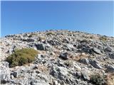 | Kosmadei - Zastano (Samos) (no. 11 / 10)
Zastano (Gr. Ζάστανο), also Zestani (Gr. Ζεστάνι), is at 1,206 m the second-highest mountain on the Greek island of Samos. It is located in the K...
3 h 10 min |
 | Buzet Railway Station - Muzari (via Žbevnica)
Muzari is a grassy peak located between Špičasti vrh and the better-known Žbevnica, specifically on the marked path from Golič to Žbevnica. On th...
3 h 15 min |
| Buzet Railway Station - Muzari (gentle path)
Muzari is a grassy peak located between Špičasti vrh and the better-known Žbevnica, specifically on the marked path from Golič to Žbevnica. On th...
3 h 25 min |
 | Matke - Homič (past Kočet and on logging trail)
Homič is one of the peaks on the Prebold mountain trail, located northwest of the slightly higher and more famous Mrzlica. From the summit, where...
2 h 25 min |
| Matke - Homič (via Kočet and Kriška planina)
Homič is one of the peaks on the Prebold mountain trail, located northwest of the slightly higher and more famous Mrzlica. From the summit, where...
2 h 35 min |
 | Sošice - Ječmište (čez Pliješ)
Ječmište is a grassy summit above Žumberak, near Slovenia, on Žumberačka gora. The summit is an HPO point and part of the Karlovačke obilaznice. ...
2 h 30 min |
 | ŽP Buzet - Špičasti vrh (pri Žbevnici) (čez Žbevnico)
Pointed Peak is a scenic grassy peak along the marked path between Golič and Žbevnica, near the Slovenian border. The peak has a summit book box ...
3 h 30 min |
| ŽP Buzet - Špičasti vrh (pri Žbevnici) (položna pot)
Pointed Peak is a scenic grassy peak along the marked path between Golič and Žbevnica, near the Slovenian border. The peak has a summit book box ...
3 h 40 min |