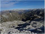
 | Tinčkova koča - Hochstuhl/Stol (via Zagon)
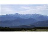
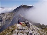
Stol is, at 2,236 m, the highest peak in the Karawanks. From the summit, which has a registration box and stamp, a beautiful view opens onto the ...
3 h 45 min |
| Urbas - Hochstuhl/Stol
Stol is, at 2,236 m, the highest peak in the Karawanks. From the summit, which has a registration box and stamp, a beautiful view opens onto the ...
3 h 15 min |
 | Razpotje Vragovec - Hochstuhl/Stol (via Doslovška planina and hunting cottage)
Stol is, at 2,236 m, the highest peak in the Karawanks. From the summit, which has a registration box and stamp, a beautiful view opens onto the ...
3 h 10 min |
| Tinčkova koča - Hochstuhl/Stol (via hunting cottage above Doslovška planina)
Stol is, at 2,236 m, the highest peak in the Karawanks. From the summit, which has a registration box and stamp, a beautiful view opens onto the ...
3 h 40 min |
 | Markova raven - Veliki Zvoh (on unmarked path via Razor)
Veliki Zvoh is the highest point of the Krvavec ski resort. The cable car does not quite reach the summit but stops only a few metres short. A fe...
3 h |
 | Uskovnica (Razpotje) - Viševnik (via source of Zlata voda)
Viševnik is a 2050 m high mountain rising northwest of Rudno polje on Pokljuka. From the summit, where there is a stamp, a beautiful view opens o...
2 h 55 min |
| Uskovnica (Lom) - Viševnik (via source of Zlata voda)
Viševnik is a 2050 m high mountain rising northwest of Rudno polje on Pokljuka. From the summit, where there is a stamp, a beautiful view opens o...
3 h 15 min |
 | Uskovnica (Lom) - Viševnik (via Gola Ravan)
Viševnik is a 2050 m high mountain rising northwest of Rudno polje on Pokljuka. From the summit, where there is a stamp, a beautiful view opens o...
3 h 10 min |
| Uskovnica (Razpotje) - Viševnik (via Gola Ravan)
Viševnik is a 2050 m high mountain rising northwest of Rudno polje on Pokljuka. From the summit, where there is a stamp, a beautiful view opens o...
2 h 50 min |
 | Križovec - Barentaler Kotschna/Struška (footpath)
Struška is a smaller mountain range located between Stol (or Belščica) and Golica. From its highest peak, Veliki vrh, there is a beautiful view o...
2 h 30 min |
 | Planina pod Golico - Barentaler Kotschna/Struška
Struška is a smaller mountain range located between Stol (or Belščica) and Golica. From its highest peak, Veliki vrh, there is a beautiful view o...
3 h |
 | Dom Pristava in Javorniški Rovt - Barentaler Kotschna/Struška (via Dobravske rovte)
Struška is a smaller mountain range located between Stol (or Belščica) and Golica. From its highest peak, Veliki vrh, there is a beautiful view o...
2 h 30 min |
| Dom Pristava in Javorniški Rovt - Barentaler Kotschna/Struška (footpath)
Struška is a smaller mountain range located between Stol (or Belščica) and Golica. From its highest peak, Veliki vrh, there is a beautiful view o...
3 h 15 min |
| Dom Pristava in Javorniški Rovt - Barentaler Kotschna/Struška (by road)
Struška is a smaller mountain range located between Stol (or Belščica) and Golica. From its highest peak, Veliki vrh, there is a beautiful view o...
3 h |
 | Planina pod Golico - Kahlkogel/Golica (via Ovčarska koča - eastern way)
Golica is a treeless peak located north of Jesenice. The summit features a registration box and offers a beautiful view of the western Karawanks ...
2 h 45 min |
 | Dom Pristava in Javorniški Rovt - Kahlkogel/Golica (on ridge)
Golica is a treeless peak located north of Jesenice. The summit features a registration box and offers a beautiful view of the western Karawanks ...
2 h 45 min |
 | Rogarjev rovt - Frauenkogel/Dovška Baba (via Rožca and Hruški vrh)
Dovška Baba is a 1891-meter-high peak located on the border ridge between Slovenia and Austria. From the summit, which has a registration box and...
2 h 30 min |
 | End of road on Vogar - Slatna (via Griva)
Slatna is a panoramic mountain located between Kreda and Prvi Vogel. From its grassy summit, which is not reached by any marked path, a fine view...
3 h 50 min |
 | Za Loncem - Deska (Veža)
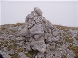
Deska is a panoramic peak located in the heart of the Dleskovška planota plateau, also known as Veža. From the summit, where a large cairn stands...
3 h 30 min |
 | Za Loncem - Tolsti vrh (Veža)
Tolsti vrh is a 1985 m high mountain located in the heart of the Dleskovška planota plateau, known as Veža. From the summit, which is covered wit...
3 h 35 min |
 | Razpotje Vragovec - Prešernova koča na Stolu (via Doslovška planina and hunting cottage)
The Prešernova koča na Stolu mountain hut is located just a few metres below the summit of the 2198 m high Mali Stol. From the hut or the nearby ...
2 h 55 min |
| Tinčkova koča - Prešernova koča na Stolu (via hunting cottage above Doslovška planina)
The Prešernova koča na Stolu mountain hut is located just a few metres below the summit of the 2198 m high Mali Stol. From the hut or the nearby ...
3 h 25 min |
 | Javorje - Rodica (via Lepa Suha)
The mountain Rodica is located above Bohinj in the Lower Bohinj Mountains. From the summit there is a beautiful view over the Julian Alps and the...
2 h 30 min |
 | Planina Blato - Ogradi
Ogradi is located between the Laz and Krstenica mountain pastures. The summit is grassy with plenty of space. A small cross stands on the top. Fr...
2 h 45 min |
| Planina Blato - Ogradi (via Planina Krstenica)
Ogradi is located between the Laz and Krstenica mountain pastures. The summit is grassy with plenty of space. A small cross stands on the top. Fr...
3 h 15 min |
 | Gate (Belca) - Techantinger Mittagskogel (Trupejevo poldne) (by road)
The mountain is located on the border with Austria above Gozd Martuljek. From the bare summit, there is a beautiful view of the Julian Alps and t...
4 h |
| Srednji vrh - Techantinger Mittagskogel (Trupejevo poldne) (via Železnica)
The mountain is located on the border with Austria above Gozd Martuljek. From the bare summit, there is a beautiful view of the Julian Alps and t...
2 h 30 min |
| Srednji vrh - Techantinger Mittagskogel (Trupejevo poldne) (via Grajšca)
The mountain is located on the border with Austria above Gozd Martuljek. From the bare summit, there is a beautiful view of the Julian Alps and t...
4 h |
 | Srednji Vrh - Techantinger Mittagskogel (Trupejevo poldne) (via valley of stream Žlebnica)
The mountain is located on the border with Austria above Gozd Martuljek. From the bare summit, there is a beautiful view of the Julian Alps and t...
2 h 45 min |
 | Gate (Belca) - Kresišče (by road)
Kresišče is an 1839 m high peak in the main ridge of the Karawanks, specifically between Kepa and Trupejevo poldne. From the summit, where a wood...
3 h |
 | Srednji Vrh - Kresišče (via Grajšca)
Kresišče is an 1839 m high peak in the main ridge of the Karawanks, specifically between Kepa and Trupejevo poldne. From the summit, where a wood...
2 h 50 min |
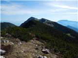
438900.th.jpg) | Gate (Belca) - Visoki vrh (by road)
Visoki vrh (also known as Visoki Kurji vrh) is an 1828 m high mountain located west of the Belca River valley. From the summit, marked by a small...
2 h 55 min |
 | Gate (Belca) - Visoki vrh (via Bašinov breg)
Visoki vrh (also known as Visoki Kurji vrh) is an 1828 m high mountain located west of the Belca River valley. From the summit, marked by a small...
2 h 40 min |
 | Urbas - Weinasch/Vajnež
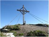
Vajnež is the highest peak of Belščica, a subrange located west of the better-known Stol. The summit features a cross and both Slovenian and Aust...
2 h 25 min |
| Olipova planina - Weinasch/Vajnež (via Hrašenska planina)
Vajnež is the highest peak of Belščica, a subrange located west of the better-known Stol. The summit features a cross and both Slovenian and Aust...
2 h 50 min |
| Dom Trilobit - Weinasch/Vajnež (via Rida)
Vajnež is the highest peak of Belščica, a subrange located west of the better-known Stol. The summit features a cross and both Slovenian and Aust...
4 h |
| Valvasorjev dom pod Stolom - Weinasch/Vajnež
Vajnež is the highest peak of Belščica, a subrange located west of the better-known Stol. The summit features a cross and both Slovenian and Aust...
3 h 30 min |
 | Planina Kuhinja - Vrh nad Peski
Vrh nad Peski is a 2176 m high mountain located east of Krn. From the summit, where there is a summit register box in the shape of a miniature Al...
4 h |
 | Planina Ravne - Veliki vrh (Veža) (via Dleskovec)
Veliki Vrh is a 2,110-metre-high mountain located in the central part of the Dleskovec Plateau. From the summit, where there are two registration...
2 h 45 min |
 | Javorje - Šija (via Kratki plaz)
Šija is located above the Vogel ski resort in the Lower Bohinj Mountains. From the summit, there is a nice view of the neighboring peaks in the s...
2 h 40 min |
 | Olipova planina - Potoški Stol
Potoški Stol is located between Stol and Vajnež on the border with Austria. A cross stands just a few metres below the grassy summit. The finest ...
2 h 40 min |
 | Podnar / Bodenbauer - Ovčji vrh (Kozjak) / Geissberg (Kosiak) (via Karweg and southeast path)
Ovčji Vrh or Kozjak, known in German as Geissberg or Kosiak, is a 2024 m high peak located north of the main Karawanks ridge. Rising above Celovš...
2 h 45 min |
| Podnar / Bodenbauer - Ovčji vrh (Kozjak) / Geissberg (Kosiak) (via Karweg and southwest path)
Ovčji Vrh or Kozjak, known in German as Geissberg or Kosiak, is a 2024 m high peak located north of the main Karawanks ridge. Rising above Celovš...
3 h |
 | Tonnerhütte - Zirbitzkogel (winter path)
Zirbitzkogel, at 2,396 m, is the highest peak of the Labotniške Alpe / Seetaler Alpen. From the summit, where a cross and a panorama board stand,...
2 h 27 min |
 | Tonnerhütte - Scharfes Eck (winter path)
Scharfes Eck is a peak on which stands an Austrian meteorological radar station. From the summit, there is a beautiful view of the neighbouring p...
2 h 45 min |
 | Rudnik v Topli - Petzen (Kordeschkopf) (Peca (Kordeževa glava)) (via Knipsovo sedlo)
Kordeževa glava, better known as Peca, is the highest peak of the Peca range. It is located on the border with Austria above the Mežiška dolina v...
2 h 45 min |
 | Planina Kuk - Žabiški Kuk (via planina Razor)
Žabiški Kuk is located on the southern side ridge of the Lower Bohinj Mountains near the more renowned Vogel and above Planina Razor. From the su...
3 h |
 | Tolminske Ravne - Žabiški Kuk (on mule track)
Žabiški Kuk is located on the southern side ridge of the Lower Bohinj Mountains near the more renowned Vogel and above Planina Razor. From the su...
3 h 45 min |
 | Planina Kuk - Vrh Planje (above Globoko)
Vrh Planje is a less prominent peak in the ridge of the Lower Bohinj Mountains, which has been increasingly visited lately. Vrh Planje (above Glo...
2 h 45 min |
 | Planina Ravne - Velika Zelenica (via Dleskovec)
Velika Zelenica is the highest peak of the Dleskovška plateau, offering panoramic views accordingly. The nearby Ojstrica stands out most prominen...
2 h 45 min |
 | Weissensee - Kopasnock (via Karalm)
Kopasnock is a lesser-known peak in the Latschur group, reached via an unmarked trail. From its grassy summit, there are beautiful views of the G...
4 h |
 | Pecol - Cima di Terrarossa
Špik Hude police is a 2431-meter-high panoramic peak (new LiDAR measurement; this height will also be shown on newer maps, while older maps still...
2 h 45 min |
 | Markova raven - Krvavec (on unmarked path via Razor)
Krvavec is a 1,853-meter-high peak located in the heart of the eponymous ski resort. From the summit, which is crisscrossed with cable cars, ther...
2 h 45 min |
 | Javorje - Raskovec (via Rodica)
Raskovec is a panoramic mountain between the more prominent Rodica and Črna prst. Its seldom-visited summit lacks a logbook or stamp but delivers...
3 h 45 min |
| Rutarski gozd - Raskovec (via Rodica)
Raskovec is a panoramic mountain between the more prominent Rodica and Črna prst. Its seldom-visited summit lacks a logbook or stamp but delivers...
3 h 30 min |
 | Rudnik v Topli - Feistritzer Spitze
Bistriška špica is a 2113 m high peak located on the Austrian side of Peca. From the summit, which features a cross, there is a fine view of the ...
3 h 30 min |
 | Rudnik v Topli - Končnikov vrh (Peca)
Končnikov vrh (German: Knieps) is a 2109 m high peak situated in the central part of Peca. From the grassy summit, there is a beautiful view of t...
2 h 30 min |
 | Rudnik v Topli - Velika glava (Peca)
Velika glava is a peak in the Peca range, located between Kordeževa glava and Končnikov vrh. From the summit, which borders Austria, a beautiful ...
2 h 30 min |
| Koprivna (Kumer) - Velika glava (Peca) (via Knipsovo sedlo)
Velika glava is a peak in the Peca range, located between Kordeževa glava and Končnikov vrh. From the summit, which borders Austria, a beautiful ...
3 h 10 min |
 | Untere Wolayeralm - Mahderkopf (via Wolayerseehütte)
Mahderkopf is a 2,155-meter-high mountain located north of the main ridge of the Carnic Alps. From its grassy summit, there is a beautiful view o...
3 h 45 min |
 | Srednji Vrh - Maloško poldne / Mallestiger Mittagskogel
Maloško poldne, or Mallestiger Mittagskogel in German, is a 1,823-meter-high peak on the border between Slovenia and Austria, precisely between T...
2 h 55 min |
 | Gate (Belca) - Maloško poldne / Mallestiger Mittagskogel (by road)
Maloško poldne, or Mallestiger Mittagskogel in German, is a 1,823-meter-high peak on the border between Slovenia and Austria, precisely between T...
3 h 10 min |
 | Vas na Skali - Čisti vrh
Čisti vrh is a 1875 m high mountain located north of the Špičje ridge, more precisely on a panoramic elevation above the Čez Drt saddle. From the...
3 h 30 min |
 | Planina Blato - Krsteniški Stog (čez Krsteniški preval)
Krsteniški Stog, or Mali Stog, is a 1879 m high mountain rising steeply above the Krstenica mountain pasture. From the summit, where a stone cair...
2 h 25 min |
 | Carbonin - Knollkopf / Col Rotondo dei Canope
The 2204 m high Knollkopf / Col Rotondo dei Canope is located in Fanes-Sennes-Prags Nature Park. Mostly covered in dwarf pines, it features a cro...
3 h |
 | Šajda / Schaidasattel - Kravji vrh / Kuhberg (via Obirsko sedlo)
Kravji vrh / Kuhberg is a two-thousander on the Obir with two approximately equally high peaks. Apart from dwarf pines, there is nothing on the h...
2 h 45 min |
 | Šajda / Schaidasattel - Kravji vrh / Kuhberg (steep path)
Kravji vrh / Kuhberg is a two-thousander on the Obir with two approximately equally high peaks. Apart from dwarf pines, there is nothing on the h...
2 h 30 min |
 | Srednji Vrh - Bele peči (Lepi vrh) (via Železnica)
Bele peči, properly also Peči or Na Pečeh (maps sometimes show Lepi vrh, which is incorrect Lepi vrh is actually a forested shoulder at the 1,47...
2 h 30 min |
| Srednji Vrh - Bele peči (Lepi vrh) (via valley of stream Žlebnica)
Bele peči, properly also Peči or Na Pečeh (maps sometimes show Lepi vrh, which is incorrect Lepi vrh is actually a forested shoulder at the 1,47...
2 h 45 min |
 | Alpengasthof Scheikl - Hohe Veitsch (up along the southern ridge)
Hohe Veitsch is the highest peak of the Veitsch mountain range, located in the eastern part of the Northern Limestone Alps. From the summit, a be...
2 h 35 min |