Pecol - Cima di Terrarossa
Starting point: Pecol (1510 m)
| Latitude/Longitude: | 46,4092°N 13,4376°E |
| |
Walking time: 2 h 45 min
Difficulty: easy unmarked way
Elevation gain: 921 m
Elevation difference along the route: 921 m
Map: Julijske Alpe - zahodni del 1:50.000
Recommended equipment (summer): helmet
Recommended equipment (winter): helmet, ice axe, crampons
Views: 175.789
 | 7 people like this post |
Access to starting point:
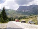
a) From Kranjska Gora we drive across the Rateče border crossing to Trbiž / Tarvisio. In Trbiž we continue left in the direction of Bovec and follow the road to the intersection near Rabeljsko jezero. Here we continue right in the direction of Nevejski preval (Na Žlebeh) / Sella Nevea. When the road already starts descending towards Reklanska dolina, in a sharp left turn a narrow and steep road branches off to the right towards Montaževa visoka planota / Altopiano del Montasio (at the intersection there are signs in Italian). We then follow this road to the large marked parking lot, which is located a few hundred meters before the Pecol cheese dairy (further driving is prohibited).
b) From Bovec we drive to the Predel border crossing, from which we descend to the Italian side. A little after Rabeljsko jezero we arrive at an intersection where we continue left in the direction of Nevejski preval (Na Žlebeh) / Sella Nevea. When the road already starts descending towards Reklanska dolina, in a sharp left turn a narrow and steep road branches off to the right towards Montaževa visoka planota / Altopiano del Montasio (at the intersection there are signs in Italian). We then follow this road to the large marked parking lot, which is located a few hundred meters before the Pecol cheese dairy (further driving is prohibited).
Route description:
In the intersection at the end of the parking lot we continue right towards the "Rifugio di Brazza" hut. We leave the gentle road that climbs across the Pecol plateau at the place where barely visible markings direct us left onto the footpath, which we then follow in moderate ascent to the mountain hut. From the hut we continue in the direction of "Cima di Terrarossa" along the gentle path that ascends across grassy slopes. Just a few dozen steps from the hut we come to an unmarked fork where we continue on the right path (left Montaž). The increasingly scenic path takes us higher to the steep slopes of Špik Hude police. Here, due to the considerable number of ibex that often dislodge rocks, it is wise to put on a helmet. We continue ascending along the old military mule track, which is not marked. The moderately steep path along which we can constantly observe numerous ibex takes us higher to a marked fork where we continue on the left path in the direction of "Terrarossa" (right "Ceria Merlone"). The still unmarked path takes us a little further to the next marked fork, where we continue right (left Montaž). The increasingly rocky path then takes us to a smaller notch in the main ridge. We continue left and then after another good 5 minutes of walking along the scenic summit slope we step onto the summit of Špik Hude police.
The path is not marked but is indicated at the forks, so there are no major orientation difficulties.

Photos:
 1
1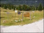 2
2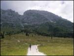 3
3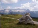 4
4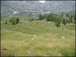 5
5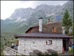 6
6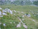 7
7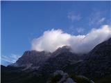 8
8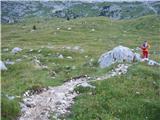 9
9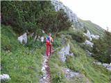 10
10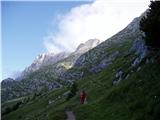 11
11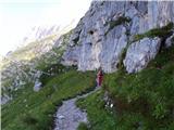 12
12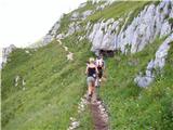 13
13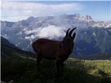 14
14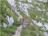 15
15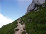 16
16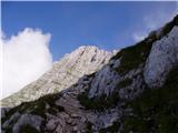 17
17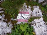 18
18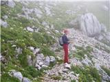 19
19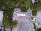 20
20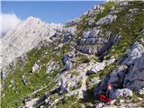 21
21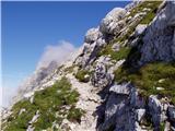 22
22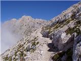 23
23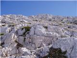 24
24 25
25
Discussion about the trip Pecol - Cima di Terrarossa
Show older messages
|
| majdicst25. 08. 2008 |
Good description. Maybe add that last few meters below summit path quite polished, caution advised. Summit crowded on my visit, sat lower watching chamois stuck north side, took 10 min to safety.
Rockfall main issue - not just chamois but careless hikers too - easy path attracts many.
Up and down sharp marmot whistles, saw some guarding holes, vanishing at danger sign.
Recommend trip for families with kids and via ferrata fearful wanting respectable 2000m peak.
|
|
|
|
| Reny5. 09. 2008 |
That day when I was up there, fog was rolling all the time, so unfortunately I didn't see Montaž, but at least the upper half opened up to views of Viš and surroundings... My partner and I were the only and last ones on the summit that day, it was around 4 pm. I believe everyone crowds the summits in the morning. Since the trip is shorter and really easier, I recommend starting around noon, if the weather is friendly and of course NOT clear. I had no problems crossing under the summit, and no stones were falling down either. Probably due to the worse weather in the afternoon /?/. GREAT trip!
|
|
|
|
| triglavski5. 09. 2008 |
You have to go to the mountains in the morning, not at noon. Given this summer with quite a lot of moisture, even on an otherwise clear day, fog forms on southern slopes around 10 or 11 o'clock and then there's no view. I was up there on 30.8 first of course on Montaž, around 9 o'clock it was beautifully clear, then I descended via vrh Brda to the scree and via A.E. Leva under Špik Hude police, at noon everything was foggy, but huge crowds were still pushing up. What they saw I don't know, probably nothing but fog, well they were on the summit anyway and that counts for something, but the view from there is wonderful, so I recommend morning again. Otherwise of course in winter and in beautiful autumn with perfectly clear days.
|
|
|
|
| Kriška6. 09. 2008 |
In the mountains this rule still holds more or less, but at least in the valley (Gorenjska, approx. 500 m a.s.l.) this year I've noticed a real reversal: worse weather (clouds) in the morning and forenoon, around noon it clears up considerably, clouds dissipate for a few more hours and by evening it's practically clear.
I don't quite understand how and why this change happened and it bothers me a bit, because this year I've already several times been "tricked" even with the usual early morning start to the mountains - I was at the summit in cloudy weather, but on return to the start the sun was shining - yes, even on the summit I visited before. 
|
|
|
|
| geppo7. 09. 2008 |
This case was very noticeable this year also in the Kamnik and Savinja Alps. Fog - clouds were carried at high speed from Gorenjska, and then lingered on the peaks (Skuta, Brana, Planjava, Rinka, Ojstrica..) - usually the peaks Mrzla gora, Olševa, Raduha and the entire visible part of Austria were clear without clouds.
Usually, but this cloudiness cleared after 3 pm and the peaks were in the sun. So, we were also often in the fog on these peaks in the morning - we admired (at moments when it cleared) the listed peaks in the sun! In the afternoon, everything cleared up.
Best regards
|
|
|
|
| zvezdana23. 09. 2008 |
Is there already snow on the mountain?
|
|
|
|
| damijanp25. 08. 2009 |
Very nice trip. Especially the daughters liked it, mainly because of the ibex and one marmot, very much.
Some photos are at the following link:
Špik Hude police
|
|
|
|
| Pujska27. 10. 2009 |
Will I find snow if I go there? Is the trail more southern or more northern in the summit section? I don't have crampons so I wonder if I can go anyway. Thanks.
|
|
|
|
| triglavski27. 10. 2009 |
I'll say in the evening, just now heading to Pecol, best regards
|
|
|
|
| triglavski27. 10. 2009 |
In the summit section of Špik Hude police there is some snow, in the morning this area is in shade, later there is plenty of sun, since it's a fairly wide path, there shouldn't be problems, as the snow melts during the day, of course some section might be frozen. In short, need to check on site. An ice axe isn't superfluous, you can help yourself quite a bit with it. Picture of Špik h.p. will be posted under Current conditions (Strma peč - Monte Cimone). Otherwise, I recommend this one exactly, it's dry throughout.
|
|
|
|
| ania22. 11. 2009 |
hi, I was up there today. beautiful views, warm, no clouds, only disturbed by VERY STRONG wind at the summit  . .
LP A.
|
|
|
|
| benjamin722. 08. 2010 |
Yesterday exceptionally nice day and therefore a very visited summit with many Slovenes, the path excellently laid out. Descent then along part of Ceria Merlone and then direct descent from Škrbina above Tratica on a slightly less trodden path towards Pecol.
|
|
|
|
| benjamin722. 08. 2010 |
Pardon, well-trodden path.
|
|
|
|
| Enka12. 09. 2010 |
Exceptionally beautiful trail, suitable for a family outing - nothing demanding and nothing exposed, just some fitness required. We didn't see marmots (we were too late), but some ibex came very very close to us. Truly fascinating for children. At the top - views you can only dream about. Gorgeous!
|
|
|
|
| Enka12. 09. 2010 |
Oh, one more thing. Even though during the heavy crowd we were probably the only ones who put on helmets, we didn't regret it. We "met" quite a few solid stones, one landed just a meter away from the girl. And it wasn't triggered by ibex.
|
|
|
|
| falcon1. 11. 2010 |
We visited this summit, pure beauty, saw a marmot mother calling her wandering young; when he appeared, he got a slap and mom chased him into the burrow. Higher up we walked among chamois, they act like mountain guides as they walk ahead of you on the trail. Views from the top are unique. This summit is becoming our obligatory annual tour, but there's always something new. Higher up we walked among chamois, they act like mountain guides as they walk ahead of you on the trail. Views from the top are unique. This summit is becoming our obligatory annual tour, but there's always something new.
|
|
|
|
| neph18. 07. 2011 |
Very nice and technically undemanding tour. Marmots and ibex are really constant companions. The path is zigzagged, so there is danger of falling rocks if visitors above us knock something loose. In case of crowds I would therefore recommend a helmet, in any case caution.
|
|
|
|
| ninooos28. 10. 2011 |
Has anyone been walking around here in the last few days? I'm interested in the snow conditions?
|
|
|
|
| Lunatic25. 04. 2012 |
Is the road to pl. Pecol normally drivable with summer tires? Regards.
|
|
|
|
| potepinka25. 04. 2012 |
If you mean these days - on TK Gora it says that snow has fallen even in Neveji (or is it na?), which to me means that the road to Pecol is not exactly clear. I might be wrong, but if you look at the surrounding webcams the snow is quite low.
|
|
|
|
| IgorZlodej25. 04. 2012 |
It's true there is snow in Neveja and the road is snowy too, and it really shows on the cameras, you just have to make a little effort to look . .
|
|
|
|
| Matjaz_656. 08. 2012 |
some photos from the Špik Hude police path - left ferrata - Findenegg glacier - Montaž 
|
|
|
|
| zbil15. 09. 2012 |
Has anyone been to the mountain in the last few days after the snowfall?
|
|
|
|
| valerija11222. 08. 2013 |
Hello! Today we did the route described above. Everything nice written holds true. I recommend it to all who seek beautiful views, flowers, chamois. No pegs and wires, enjoyment 100 per hour.
|
|
|
|
| slavkoo17. 09. 2013 |
Real pleasure, we walked exactly 2 hours and 2 minutes, looking at marmots and ibex our dog - cocker spaniel also enjoyed. Wonderful view, recommend. On descent visit rifugio Brazza.
|
|
|
|
| K821. 03. 2014 |
Does anyone have info on current snow conditions on this path?
|
|
|
|
| IgorZlodej21. 03. 2014 |
From the starting point to the summit everything under snow 
|
|
|
|
| K822. 03. 2014 |
Haha, I know that I was interested if anything is trodden...
|
|
|
|
| IgorZlodej22. 03. 2014 |
It was there up to Pecol, but tomorrow it won't be anymore, when I was on Friday at Škrbina above Tratica there were no visible tracks, possibly someone from Zajzera under Žleb Hude police, from that side it's very rarely walked at this time, great exposure to avalanches, but actually the whole slope is one big avalanche terrain, see Turni-klub-gora, where I posted some photos.
|
|
|
|
| zbil17. 10. 2014 |
What are the current conditions on the path? Is there any snow?
|
|
|
|
| redbull17. 10. 2014 |
when did it snow in the last month?
|
|
|
|
| Janiel7417. 10. 2014 |
It snowed exactly on 25.9.2014.
|
|
|
|
| redbull17. 10. 2014 |
well you see, not in October
|
|
|
|
| redbull17. 10. 2014 |
Sunday would be warmer than August days
|
|
|
|
| andrejp3. 11. 2014 |
Yesterday my better half and I sunbathed up there. To spice up the whole thing even more, on the way back we detoured to ferrata Leva (nicely passable) and then to the valley. There were no such days this summer like the last few.
A
|
|
|
|
| petruša12. 07. 2015 |
Something interests me about this pasture Pecol. Do you go to this pasture in Sella Nevea itself or before. And it's written Pecol or in Italian, because last year we looked for this pasture and didn't find it. Please sensible comments, not offensive ones. Maybe someone has a picture where you turn to this pasture. Best
|
|
|
|
| IgorZlodej12. 07. 2015 |
Actually, it's the High Montasio Plateau, there is no Pecol pasture, but it's Planina Montasio. The road starts at Na Žlebeh in a sharp left turn, impossible to miss, otherwise there are car and hiking maps, GPS and so on, like somehow when Kugy went over Mauria Pass to the Dolomites and saw an interesting mountain, by the road a farmer mowing grass and asked him the name, he learned everything in an instant and the next day already stood on its summit
|
|
|
|
| valerija11212. 07. 2015 |
Petruša, I too last year read the above description poorly and drove straight on, then turned around and read it again. As written above and Igor says, when the road starts descending, there's a sharp left turn (if you reach the end of the settlement, you've already missed it) and a sign for Pl. Montasio. Then just to the end along the narrow asphalt road to the pasture. Go, you won't regret it. Up there is a real mountaineer's paradise, wherever you're heading. Good luck.
|
|
|
|
| VanSims12. 07. 2015 |
Since I was there again yesterday: the junction is just after the top of the Na Žlebeh saddle (Sella Nevea). If you've reached the tunnel, you've probably missed it. The name Igor gave is correct Slovenian but doesn't help you because the sign at the junction is in Italian: "Altopiano del Montasio"
Pecol is only the name of the cheese dairy on this pasture - according to the no-entry sign at the parking lot, which allows further driving only for visitors to the Pecol cheese dairy.
It would be nice if the administrator corrected this so others don't have problems. When I first went there, I had problems too.
|
|
|
|
| petruša13. 07. 2015 |
Thanks everyone, in August when we go on vacation to Bovec area, we'll search for it, if not we'll surely find someone who knows Slovenian. We have a map, but even on it you don't know exactly where to turn right. It helps me that I know how it's written in Italian. Since last year we made it to the Dolomites, we'll try to find this too. Regards
|
|
|
|
| fissh13. 06. 2016 |
Hi, I'm interested in what the current conditions are like?
|
|
|
|
| IgorZlodej13. 06. 2016 |
What are the conditions like?
|
|
|
|
| fissh13. 06. 2016 |
Generally for the tour... snow conditions, if winter gear is needed...?
|
|
|
|
| IgorZlodej13. 06. 2016 |
Today I was on the other side under Vršič, there is one snowfield in the lower part and a few smaller ones higher up, somewhere in the area of the Ceria - Merlone path. Such questions are posted under Forum - Conditions. Otherwise, these days the weather is still okay in the morning, showers in the afternoon, today there were three or four in three hours
|
|
|
|
| smatjaz28. 12. 2016 |
GPS track is in Julijci under
Pecol - Špik Hude police / Cima di Terrarossa
|
|
|
|
| sgabor17. 04. 2017 |
Hi, I plan to go to Špik Hude police this weekend. Is the trail safe enough? Any snow left? Thanks for info. Regards
|
|
|
|
| Pelca25. 04. 2017 |
Is there a stamp at the summit?
|
|
|
|
| gmirko14. 06. 2017 |
Is the stamp perhaps in the hut...?
|
|
|
|
| ljubitelj gora19. 08. 2017 |
Yesterday late afternoon to Špik Hude police, the path is easy and offers beautiful views. Also suitable for families. Met many chamois. Parking at pl.Pecol is large and free, no toll to here up, as there never was one
|
|
|
|
| zavratčan13. 07. 2018 |
Is it possible to take this path with a dog, German Shepherd?
|
|
|
|
| VanSims13. 07. 2018 |
Taking into account all rules for hiking with a dog in the mountains and everything the dog needs to have as 'equipment' for such an endeavor, easily!
|
|
|
|
| turbo13. 07. 2018 |
Definitely. I was up there twice with my little female dog (Parson Russell), which is small anyway, but once at the top I met a husky (maybe it was a malamute  ), so I think there won't be problems. Definitely on a leash, as there are lots of ibex and some graze right next to the path, almost so you can pet them. ), so I think there won't be problems. Definitely on a leash, as there are lots of ibex and some graze right next to the path, almost so you can pet them.
P.S.
those two are also with a dog
https://www.avventurosamente.it/xf/threads/cima-terrarossa.22029/
Good luck!
|
|
|
|
| zavratčan13. 07. 2018 |
The ibex will move away, so there won't be any outbursts from our little female dog
|
|
|
|
| ločanka31. 08. 2018 |
A helmet is definitely recommended. A lady said this week at the summit that she has an acquaintance who was hit by a stone on this very path, triggered by ibex. Apparently she was in treatment for several years.
|
|
|
|
| ločanka31. 08. 2018 |
A helmet is definitely recommended. A lady said this week at the summit that she has an acquaintance who was hit by a stone on this very path, triggered by ibex. Apparently she was in treatment for several years.
|
|
|
|
| Jani33316. 07. 2019 |
Hello,
Is the summit stamp perhaps located in the Brazza hut?
thanks for the reply
|
|
|
|
| mirank16. 07. 2019 |
I think there probably never was a stamp up there, it's true I wasn't paying attention to it either. I don't collect stamps, but since we often go to Italy I notice that summits there - even the more important ones - are rarely equipped with stamps.
|
|
|
|
| gmirko16. 07. 2019 |
There is no summit stamp either at the summit or in the hut, but there is a hut stamp in the hut....
|
|
|
|
| Jani33319. 07. 2019 |
mirank, gmirko... thanks for the reply
|
|
|
|
| Majdag21. 07. 2019 |
20.7.... Špik Hude police. At Pecol around 12:00 everything was blocked with sheet metal. Even further down along the road there were plenty. Queue in the morning and queue back, tiring drive. Otherwise up to the alpine pasture, the last part of the road newly asphalted. The mountain as always, super and views beautiful.
https://jelenkamenmajdag.blogspot.com/2019/07/spik-hude-police.html
|
|
|
|
| Andreja80819. 08. 2019 |
18.8.2019. We left Ljubljana at 6. Followed by just under 2 hours of driving. No traffic on the road. At the parking lot at Pecol there were already quite a few cars. We started the ascent and reached the summit in approximately the described time. On the way we met some hikers, but we could ascend at our own pace and in peace. The sun warmed us along the trail and the magnificent views. Ibex greeted us, posing very close up. Seeing these beautiful animals warmed our hearts. The summit was quite crowded as there is little space and it's quite exposed. Caution in crowds is not superfluous. We enjoyed the views for a while then started descending. It was quite hot, even though mists were already appearing in the valley. On the descent we met a large number of hikers (after 12:30). Upon return to the planina there were tons of cars and more coming. Very nice tour, the ascent is not too demanding, a bit more caution needed at certain spots, especially near the summit, otherwise an easy trail with wonderful views, flowers and ibex. Be early and you'll be rewarded ;-)
|
|
|
|
| simon7911. 10. 2019 |
Has anyone been on this trail in the last week? Is it possibly (slightly) icy anywhere?
|
|
|
|
| Barbara 7520. 06. 2024 18:02:56 |
Hello, could you please give info on how steep the road to the parking lot at Pecol is?
Barbara
Thank you
|
|
|
|
| turbo20. 06. 2024 19:05:01 |
|
|
|
|
| Klinar2722. 06. 2024 01:15:24 |
The biggest problem there are the driving specialists we call Italians
|
|
|
|
| 1muha22. 06. 2024 12:03:04 |
It's steep, in a couple of hairpin turns you need to shift into first and it goes. Car, van, minibus, bus, everything gets up just slowly.
|
|
|
|
| turbo22. 06. 2024 19:30:27 |
|
|
|
|
| Barbara 758. 07. 2024 11:50:54 |
Thanks everyone for the information☺️
|
|
|
|
| natasacraine31. 10. 2024 08:22:13 |
Hello, do you have to pay for parking at Pecol?
Thanks,
N.
|
|
|
|
| mirank31. 10. 2024 17:43:09 |
It's not in Gorenjska
|
|
|
|
| Grega9230. 05. 2025 22:21:44 |
Hello
Has anyone been to Pecol recently, is the road open?
Thanks
|
|
|
|
| Stane731. 05. 2025 07:59:45 |
The road is normally passable, there was still quite a bit of snow visible on the path to the summit. I didn't go up, so I don't know if it's passable.
|
|
|
|
| djimuzl31. 05. 2025 15:45:49 |
From the Brazza hut, which opened today, they report snow on certain sections above 1900 meters in the entire Montaža group, including Špik Hude police.
|
|
|
|
| Acibujl30. 06. 2025 09:40:30 |
28.6.2025
Wonderful summit, reached via a pleasant path, well traceable, surrounded by alpine flowers. Curious chamois kept us company... Heavenly views, a beautiful day in the heart of the most beautiful mountains! From Pecol past the Brazza hut at a moderate pace you are at the summit in three hours, with obligatory stops to take photos and admire the views... helmet highly recommended! Now hit the trail and enjoy the beautiful mountain world.😉
|
|
|
To post a comment you must log in:
If you do not yet have a username, you must first
register.