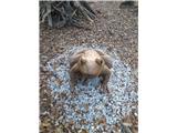
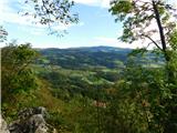
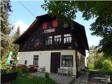
 | Lovska koča Muljava - Mali Petrovac (Petrova gora) (Roman path)
Mali Petrovac is a rather low hill located somewhere on the border between Banja and Kordun, Pannonian Croatia and Gorski Kotar. The top is compl...
1 h |
 | Hunting cottage Muljava - Mali Petrovac (Petrova gora) (via Mali Velebit)
Mali Petrovac is a rather low hill located somewhere on the border between Banja and Kordun, Pannonian Croatia and Gorski Kotar. The top is compl...
1 h 15 min |
 | Rdeči Kal - Ostri vrh (above Globodol) (via Velika raven)
Ostri vrh is a 523 m high peak located between Vrbovec, Rdeči Kal, Gorenji, Sredni and Dolenji Globodol, Dolni and Gorni Ajdovec and Podlipa. The...
1 h 15 min |
 | Ljubljana (Zalog) - Debenji vrh
Debenji vrh, also Debni or Deben vrh, is the highest peak of Kašeljski Hill, a small mountain range located between the valley of Besnica and the...
45 min |
 | Ljubljana (Zalog) - Debenji vrh
Debenji vrh, also Debni or Deben vrh, is the highest peak of Kašeljski Hill, a small mountain range located between the valley of Besnica and the...
45 min |
 | Brezovica pri Ljubljani (Radna) - Gradišče (above Dobrova)
Gradišče is a forested peak located south of Dobrova and north of Brezovica pri Ljubljani. There is no view from the top, where there is a box wi...
45 min |
 | Tremerje - Vipota
Vipota is a 532-metre-high peak south of Celje, above the left bank of the Savinja. Approaches to the summit are possible from several directions...
1 h |
 | Zagrad - Vipota
Vipota is a 532-metre-high peak south of Celje, above the left bank of the Savinja. Approaches to the summit are possible from several directions...
1 h |
 | Zagrad - Vipota (via crossing Ivankovič)
Vipota is a 532-metre-high peak south of Celje, above the left bank of the Savinja. Approaches to the summit are possible from several directions...
1 h 15 min |
 | Zbelovo (railway underpass) - Ljubična gora (via Marijine stopinje)
Ljubična gora is a hill located above Ljubično, Zbelovo and Zbelovo Gora. The hill is hidden in the forest and is not very visible, but the churc...
45 min |
 | Zbelovo (railway underpass) - Ljubična gora
Ljubična gora is a hill located above Ljubično, Zbelovo and Zbelovo Gora. The hill is hidden in the forest and is not very visible, but the churc...
45 min |
 | Zgornje Poljčane - Ljubična gora
Ljubična gora is a hill located above Ljubično, Zbelovo and Zbelovo Gora. The hill is hidden in the forest and is not very visible, but the churc...
1 h 15 min |
 | Velika Kostrevnica - Kožljevec
Kožljevec (also Kožlevec) is a 533 m high hill above Cerovica in the municipality of Šmartno pri Litija. The top, which also has a box with a reg...
1 h 10 min |
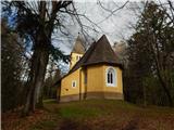
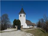 | Naraplje - Church of St. Bolfenk (Jelovice)
The Church of St. Bolfenko is situated on a 537-metre-high hill above Jelovice. From the top, you can enjoy a beautiful view of the Haloze and Bo...
1 h |
| Stogovci (Vabča vas) - Church of St. Bolfenk (Jelovice)
The Church of St. Bolfenko is situated on a 537-metre-high hill above Jelovice. From the top, you can enjoy a beautiful view of the Haloze and Bo...
1 h |
 | Brezje pri Dobrovi - Vrh (Debeli hrib) (via Strmca)
The summit is a 540 m high hill located on the Debeli hrib ridge, a ridge situated between the Ljubljana Marshes and the Horjulščice River valley...
1 h 15 min |
 | Dragomer - Vrh (Debeli hrib) (on Pentlja)
The summit is a 540 m high hill located on the Debeli hrib ridge, a ridge situated between the Ljubljana Marshes and the Horjulščice River valley...
1 h |
 | Okrog (Lazar) - Zaplaz
Zaplaz is a 543-metre-high hill located above Čatež, a village known mainly for the destination of the Levstik Trail (From Litija to Čatež). On t...
1 h 10 min |
| Bridge over Dušica - Zaplaz
Zaplaz is a 543-metre-high hill located above Čatež, a village known mainly for the destination of the Levstik Trail (From Litija to Čatež). On t...
1 h |
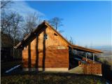
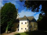
 | Galicija - Planinski dom Šentjungert
The mountain lodge is located just a few metres below the top of Gora, on which the Church of St Kunigunde, built in the 14th century, stands. Th...
45 min |
 | Zagorica pri Dobrniču - Lisec (Liška gora)
Lisec is a 565 m high peak located north to north-east of Žužemberk and south-west of Dobrnice. On the top of the peak stands a metal cross, to w...
1 h |
 | Jakob pri Šentjurju - Rifnik
Rifnik is a 568m high peak located south of Šentjur near Celje. The summit, which is famous for its archaeological site, offers a beautiful view ...
45 min |
| Šentjur - Rifnik
Rifnik is a 568m high peak located south of Šentjur near Celje. The summit, which is famous for its archaeological site, offers a beautiful view ...
45 min |
 | Gorica pri Slivnici - Rifnik
Rifnik is a 568m high peak located south of Šentjur near Celje. The summit, which is famous for its archaeological site, offers a beautiful view ...
1 h 15 min |
| Vezovje (avtobusna postaja Vezovje most) - Rifnik
Rifnik is a 568m high peak located south of Šentjur near Celje. The summit, which is famous for its archaeological site, offers a beautiful view ...
45 min |
 | Žička kartuzija - Babček (via crossing Podgranček)
Babček, an undistinguished peak on the mountain trail between Konjiška Gora and Boč. An asphalt road leads practically under the peak itself. The...
1 h 10 min |
 | Žička kartuzija - Babček
Babček, an undistinguished peak on the mountain trail between Konjiška Gora and Boč. An asphalt road leads practically under the peak itself. The...
1 h 10 min |
 | Sveti Lovrenc (Podčetrtek) - Zavetišče Šmarnica na Mali Rudnici (mimo gradu Podčetrtek)
...
1 h 5 min |
| Sveti Lovrenc (Podčetrtek) - Zavetišče Šmarnica na Mali Rudnici
...
1 h |
 | Trebnje Castle - Trebni vrh (steep path)
Trebni vrh is a 581-metre-high hill located south or south-west of Trebnje. On the top of the forested hill there is a bench, and near it there i...
45 min |
| Trebnje Castle - Trebni vrh (via caves)
Trebni vrh is a 581-metre-high hill located south or south-west of Trebnje. On the top of the forested hill there is a bench, and near it there i...
50 min |
 | Šahovec - Trebni vrh (Baragova pot)
Trebni vrh is a 581-metre-high hill located south or south-west of Trebnje. On the top of the forested hill there is a bench, and near it there i...
1 h 5 min |
| Trebnje Castle - Trebni vrh (steep path via hunting cottage)
Trebni vrh is a 581-metre-high hill located south or south-west of Trebnje. On the top of the forested hill there is a bench, and near it there i...
55 min |
| Trebnje Castle - Trebni vrh (via caves and hunting lodge)
Trebni vrh is a 581-metre-high hill located south or south-west of Trebnje. On the top of the forested hill there is a bench, and near it there i...
1 h |
 | Migojnice - Dom na Bukovici
The Bukovica Mountain House is located just a few metres below the top of the forested Bukovica. From the house, near which there is a large mead...
45 min |
 | Ljubljana (Podutik) - Toško Čelo
Toško Čelo is a 590 m high hill above the village of the same name. From the top, or slightly lower down, you have a beautiful view of part of Lj...
1 h |
 | Bad Gleichenberg (Eichgraben Weg) - Gleichenberger Kogel (via Mühlsteinbruch)
The Gleichenberger Kogel is a 598-metre-high volcanic mountain located above Bad Gleichenberg in Styria, Austria....
1 h 10 min |
| Bad Gleichenberg (Eichgraben Weg) - Gleichenberger Kogel
The Gleichenberger Kogel is a 598-metre-high volcanic mountain located above Bad Gleichenberg in Styria, Austria....
1 h 5 min |
 | Polhov Gradec - Visoki hrib
Visoki hrib is a 602 m high hill located south of Polhov Gradec. The summit, partly covered by forest, offers a beautiful view, especially to the...
1 h 15 min |
 | Oplotnica - Sveti Mohor (Lačna Gora)
The Church of Sts. In front of the church there is a registration box with a registration book and a stamp....
45 min |
 | Šešče pri Preboldu - Dragov dom na Homu (via Lajnarjev hrib)
Drago's home is located on a scenic hill, south of Šempeter. From the top, which is also the Church of St. Magdalene, there is a beautiful view f...
1 h |
| Šešče pri Preboldu - Dragov dom na Homu (Brdovska pot)
Drago's home is located on a scenic hill, south of Šempeter. From the top, which is also the Church of St. Magdalene, there is a beautiful view f...
1 h 15 min |
 | Tremerje - Veliki Slomnik
Veliki Slomnik is a peak located between Košnica pri Celju and Liboje. There is no view from the summit, which has a registration box, due to the...
1 h |
 | Bad Gleichenberg (Sägewerk Weiss) - Stradner Kogel
Stradner Kogel is the highest hill in south-eastern Styria. The hill is of volcanic origin, and its vegetation prevents views in any direction. O...
1 h 15 min |
| Haag - Stradner Kogel
Stradner Kogel is the highest hill in south-eastern Styria. The hill is of volcanic origin, and its vegetation prevents views in any direction. O...
1 h 10 min |
 | Zreče (Terme Zreče) - Golika
Golika is a 609-metre-high peak on Brinjeva Gora, on which the Church of St Neže stands....
50 min |
 | Lovnik - Rančka
...
1 h |
 | Zreče (Terme Zreče) - Brinjeva gora (above Zreče) (on PP1)
Brinjeva gora is a remarkable hill located between Zreče and Oplotnica. Brinjeva gora is famous for its several churches, which are located in a ...
45 min |
| Zreče (Terme Zreče) - Brinjeva gora (above Zreče) (via farm Pudgrošek)
Brinjeva gora is a remarkable hill located between Zreče and Oplotnica. Brinjeva gora is famous for its several churches, which are located in a ...
50 min |
 | Zreče (Terme Zreče) - Brinjeva gora (above Zreče) (via Golika)
Brinjeva gora is a remarkable hill located between Zreče and Oplotnica. Brinjeva gora is famous for its several churches, which are located in a ...
1 h |
 | Puštal (Na Dobravi) - Sveti Andrej (above Zminec)
The Church of St Andrew is located on a hill overloking the village of Sv. The church offers a beautiful view of Škofjeloško and Polhograjsko hri...
1 h 15 min |
 | Sveti Lovrenc (Podčetrtek) - Silavec (Stolp zdravja in veselja na Rudnici) (lažja pot)
...
1 h 15 min |
| Sveti Lovrenc (Podčetrtek) - Silavec (Stolp zdravja in veselja na Rudnici) (težja pot)
...
1 h 15 min |
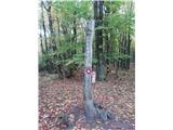
 | Dolenja vas (Kosmulj) - Ključ
Ključ is a forested peak located north of Brezje pri Dobrovi and south of Dolenje vas. There is no view from the top where the registration box w...
1 h 10 min |
 | Sveti Urh - Ključ
Ključ is a forested peak located north of Brezje pri Dobrovi and south of Dolenje vas. There is no view from the top where the registration box w...
1 h |
 | Grgar - Frančiškov hrib
Frančiškov hrib is a less prominent peak located on Skalnica, whose highest peak is the 681-metre Sveta Gora. From the lookout peak, on which the...
1 h 15 min |
 | Rašica - Rašica (Vrh Staneta Kosca) (by road)
Vrh Staneta Kosca, better known as Rašica, is located north of Ljubljana, specifically above the village of Rašica and Dobena. From the top of th...
55 min |
| Rašica - Rašica (Vrh Staneta Kosca) (footpath)
Vrh Staneta Kosca, better known as Rašica, is located north of Ljubljana, specifically above the village of Rašica and Dobena. From the top of th...
55 min |
 | Selo pri Vodicah - Rašica (Vrh Staneta Kosca) (old path)
Vrh Staneta Kosca, better known as Rašica, is located north of Ljubljana, specifically above the village of Rašica and Dobena. From the top of th...
1 h 15 min |
 | Spodnje Dobeno - Rašica (Vrh Staneta Kosca)
Vrh Staneta Kosca, better known as Rašica, is located north of Ljubljana, specifically above the village of Rašica and Dobena. From the top of th...
50 min |
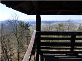
 | Gora - Trstelj
Trstelj is the highest peak in the Black Hills ridge. The view from the vast summit, where the TV transmitters stand, is split in half. From the ...
50 min |
 | Zazid - Jampršnik
Jampršnik is a little-known and even less visited peak located in the mountain chain southwest of Črni Kalo. Despite its modest height, the summi...
1 h |
 | Kozje - Raskože (Bohor) (via Vetrnik)
Raskože is a 650-metre-high peak in the eastern part of Bohor. Some also call this area Vetrnik. The south side of the peak is dominated by fores...
1 h 15 min |
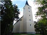
 | Šmartno - Šmarna gora (Šmartinska way)
Šmarna gora is a 669 m high peak located north-west of the capital of Slovenia. The summit, which has a restaurant and a church, offers a beautif...
50 min |
 | Tacen - Šmarna gora (via Spodnja Kuhinja)
Šmarna gora is a 669 m high peak located north-west of the capital of Slovenia. The summit, which has a restaurant and a church, offers a beautif...
55 min |
 | Šmartno - Šmarna gora (Partizanska way)
Šmarna gora is a 669 m high peak located north-west of the capital of Slovenia. The summit, which has a restaurant and a church, offers a beautif...
45 min |
 | Vikrče - Šmarna gora (via Zatrep)
Šmarna gora is a 669 m high peak located north-west of the capital of Slovenia. The summit, which has a restaurant and a church, offers a beautif...
1 h 10 min |
 | Tacen - Šmarna gora (Partizanska steza)
Šmarna gora is a 669 m high peak located north-west of the capital of Slovenia. The summit, which has a restaurant and a church, offers a beautif...
1 h |
| Tacen (Sveti Jurij) - Šmarna gora (Romarska pot)
Šmarna gora is a 669 m high peak located north-west of the capital of Slovenia. The summit, which has a restaurant and a church, offers a beautif...
1 h |
| Tacen (Sveti Jurij) - Šmarna gora (Partizanska steza)
Šmarna gora is a 669 m high peak located north-west of the capital of Slovenia. The summit, which has a restaurant and a church, offers a beautif...
1 h |
| Lipa - Šmarna gora (path via Peski)
Šmarna gora is a 669 m high peak located north-west of the capital of Slovenia. The summit, which has a restaurant and a church, offers a beautif...
55 min |
| Lipa - Šmarna gora (by road)
Šmarna gora is a 669 m high peak located north-west of the capital of Slovenia. The summit, which has a restaurant and a church, offers a beautif...
1 h 5 min |
 | Vikrče - Šmarna gora (Kovačeva steza)
Šmarna gora is a 669 m high peak located north-west of the capital of Slovenia. The summit, which has a restaurant and a church, offers a beautif...
1 h 10 min |
| Spodnje Pirniče - Šmarna gora (Kovačeva steza)
Šmarna gora is a 669 m high peak located north-west of the capital of Slovenia. The summit, which has a restaurant and a church, offers a beautif...
1 h 10 min |
| Spodnje Pirniče - Šmarna gora (learning trail)
Šmarna gora is a 669 m high peak located north-west of the capital of Slovenia. The summit, which has a restaurant and a church, offers a beautif...
1 h 10 min |
 | border crossing Lipica - Kokoš (steep way)
Koča na Kokoši is located at the top of Jirmanec, just 5 minutes away from the forested Kokoša. The summit, located south of the Lokavsko polje a...
50 min |
| border crossing Lipica - Kokoš (by road)
Koča na Kokoši is located at the top of Jirmanec, just 5 minutes away from the forested Kokoša. The summit, located south of the Lokavsko polje a...
1 h |
 | Lipica (Škibini) - Kokoš
Koča na Kokoši is located at the top of Jirmanec, just 5 minutes away from the forested Kokoša. The summit, located south of the Lokavsko polje a...
50 min |
 | Šmartno - Grmada
Grmada is a 676 m high mountain located to the west of the much more visited Šmarna Gora. From the top, where there is a small airstrip, we have ...
55 min |
| Tacen - Grmada (via Spodnja Kuhinja)
Grmada is a 676 m high mountain located to the west of the much more visited Šmarna Gora. From the top, where there is a small airstrip, we have ...
1 h |
 | Vikrče - Grmada (via Zatrep)
Grmada is a 676 m high mountain located to the west of the much more visited Šmarna Gora. From the top, where there is a small airstrip, we have ...
1 h 15 min |
 | Vikrče - Grmada (Mazijeva steza)
Grmada is a 676 m high mountain located to the west of the much more visited Šmarna Gora. From the top, where there is a small airstrip, we have ...
1 h 5 min |
| Tacen - Grmada (Mazijeva steza)
Grmada is a 676 m high mountain located to the west of the much more visited Šmarna Gora. From the top, where there is a small airstrip, we have ...
1 h 10 min |
| Tacen (Sveti Jurij) - Grmada
Grmada is a 676 m high mountain located to the west of the much more visited Šmarna Gora. From the top, where there is a small airstrip, we have ...
1 h 5 min |
 | Vikrče - Grmada (Kovačeva steza)
Grmada is a 676 m high mountain located to the west of the much more visited Šmarna Gora. From the top, where there is a small airstrip, we have ...
1 h 10 min |
 | Lipa - Grmada (path via Peski)
Grmada is a 676 m high mountain located to the west of the much more visited Šmarna Gora. From the top, where there is a small airstrip, we have ...
1 h |
| Lipa - Grmada (by road)
Grmada is a 676 m high mountain located to the west of the much more visited Šmarna Gora. From the top, where there is a small airstrip, we have ...
1 h 10 min |
| Vikrče - Grmada (on Kovačeva steza and over Sedlo)
Grmada is a 676 m high mountain located to the west of the much more visited Šmarna Gora. From the top, where there is a small airstrip, we have ...
1 h 15 min |
| Spodnje Pirniče - Grmada (learning trail)
Grmada is a 676 m high mountain located to the west of the much more visited Šmarna Gora. From the top, where there is a small airstrip, we have ...
1 h 15 min |
| Spodnje Pirniče - Grmada (on Kovačeva steza and over Sedlo)
Grmada is a 676 m high mountain located to the west of the much more visited Šmarna Gora. From the top, where there is a small airstrip, we have ...
1 h 15 min |
 | Skalnica - Sveta Gora (by road)
Sveta Gora is known mainly by the faithful and locals. Sveta Gora is a well-known pilgrimage centre above Nova Gorica. It is visited by believers...
1 h |
 | Skalnica - Sveta Gora (footpath)
Sveta Gora is known mainly by the faithful and locals. Sveta Gora is a well-known pilgrimage centre above Nova Gorica. It is visited by believers...
55 min |
 | Grgar - Sveta Gora (via Po sredi)
Sveta Gora is known mainly by the faithful and locals. Sveta Gora is a well-known pilgrimage centre above Nova Gorica. It is visited by believers...
1 h 15 min |
 | Preska - Sveti Florijan (Tehovec)
The Church of St Florian is a branch church located in the village Tehovec above Medvode. The church, which was first mentioned in 1548, offers a...
1 h 15 min |
| Sora - Sveti Florijan (Tehovec)
The Church of St Florian is a branch church located in the village Tehovec above Medvode. The church, which was first mentioned in 1548, offers a...
1 h 15 min |
 | Belica - Kregovnik
Kregovnik is a lesser known peak located on the south-eastern ridge of the 898 m high Polhograjska Grmada. The summit, which is mostly forested, ...
1 h |
 | Moravče - Gorišca
Gorišca is a 698-metre-high peak located south-west of the Ušte - Žerenk Mountain Lodge. The summit, on which the converter stands, offers no bet...
1 h 15 min |
 | Zvodno - Srebotnik (on Celje mountain trail)
Srebotnik is a lightly vegetated peak located south of Celje and Štore in the Posavje Hills. From the top, which has a registration box and a sma...
1 h 15 min |
 | Bresternica (Šoberjev dvor) - Tojzlov vrh
Tojzlov vrh is a forested hill located in the eastern part of Kozjak. On the top of the hill stands a small stone monument to the National Libera...
1 h 15 min |
 | Šober - Tojzlov vrh
Tojzlov vrh is a forested hill located in the eastern part of Kozjak. On the top of the hill stands a small stone monument to the National Libera...
1 h |
 | Sora - Hom (footpath)
Hom is a 715 m high peak rising steeply south-west of the village of Sora. The summit, which is partly covered with forest, offers a beautiful vi...
50 min |
 | Sora - Hom (by road)
Hom is a 715 m high peak rising steeply south-west of the village of Sora. The summit, which is partly covered with forest, offers a beautiful vi...
1 h 5 min |
 | Sora - Hom (less steep path)
Hom is a 715 m high peak rising steeply south-west of the village of Sora. The summit, which is partly covered with forest, offers a beautiful vi...
55 min |
 | Log - Pečke (steep path)
Pečke is an easily accessible and recently less and less visited peak located north of the main ridge of Pohorje. It receives more visitors only ...
1 h |
 | Gorenja vas - Jermanca (Jermancov grič)
Jermanca, on maps Jermanca hill, is a lookout point above Gorenjska vasje. In good weather, the summit offers a beautiful view of the peaks above...
55 min |
 | Horjul - Koreno (gentle path)
Koreno also Koreno is a 729 m high hill located north of Horjul. From the top, where there is a large cross, the Church of St. Mohorj and Fortuna...
1 h 5 min |
 | Briše - Koreno
Koreno also Koreno is a 729 m high hill located north of Horjul. From the top, where there is a large cross, the Church of St. Mohorj and Fortuna...
50 min |
| Horjul - Koreno (steep path)
Koreno also Koreno is a 729 m high hill located north of Horjul. From the top, where there is a large cross, the Church of St. Mohorj and Fortuna...
1 h |
 | Zaklanec - Koreno
Koreno also Koreno is a 729 m high hill located north of Horjul. From the top, where there is a large cross, the Church of St. Mohorj and Fortuna...
1 h 15 min |
 | Star maln - Koča na Planini nad Vrhniko
Planina above Vrhnika is for hers inhabitants something like Šmarna gora for inhabitants of Ljubljana. It is 733 metres high and is reachable fro...
1 h |
 | Blatni dol - Koča na Planini nad Vrhniko
Planina above Vrhnika is for hers inhabitants something like Šmarna gora for inhabitants of Ljubljana. It is 733 metres high and is reachable fro...
1 h 10 min |
 | Stara Vrhnika - Koča na Planini nad Vrhniko (via Kuren)
Planina above Vrhnika is for hers inhabitants something like Šmarna gora for inhabitants of Ljubljana. It is 733 metres high and is reachable fro...
1 h 15 min |
| Stara Vrhnika - Koča na Planini nad Vrhniko (via Špica)
Planina above Vrhnika is for hers inhabitants something like Šmarna gora for inhabitants of Ljubljana. It is 733 metres high and is reachable fro...
1 h 15 min |
 | Rečica ob Paki - Gora Oljka
Gora Oljka is a hill located east of Šmartno ob Paki. On the top stands the Church of the Holy Cross, which was built in the mid-18th century. Ju...
1 h 15 min |
 | Predgrad - Kozice
Kozice is a 741-metre-high peak with an RTV transmitter located above the left bank of the Kolpa River. From the lookout point on the southern pe...
1 h 15 min |
 | Socka - Kozjek (nad Socko)
Kozjek) is an interesting peak, lying west of the ridge-like Kislica as a kind of pointed extension with precipitous walls on its western side. I...
1 h 10 min |
 | Žička kartuzija - Skala
Skala is a viewpoint on the eastern part of Konjiška Gora. From the viewpoint, which has a table, bench and a registration box, there is a beauti...
1 h |
 | Marno - Dom v Gorah
The mountain lodge in Gora is located east of Hrastnik, just a few metres below the 786m-high peak on which the Church of St George stands. From ...
1 h 15 min |
 | Zreče (cemetery) - Golek
Golek is a 769-metre-high peak located north-west of Zreče. At the top there is a registration box with a registration book, a stamp and a bench,...
1 h 15 min |
 | Krašnja - Limbarska gora
Limbarska gora is located north-east of Moravce. From the top there is a beautiful view of the surrounding peaks and in good weather you can also...
1 h 15 min |
 | Slavkov dom na Golem brdu - Jeterbenk
Jeterbenk is a 774 m high peak located between Slavko's home at Gole Brdo and Katarina (Topol village). From the top, where there is a large cros...
1 h 15 min |
 | Žlebe - Jeterbenk (via Turnice)
Jeterbenk is a 774 m high peak located between Slavko's home at Gole Brdo and Katarina (Topol village). From the top, where there is a large cros...
1 h |
 | Žlebe - Jeterbenk (on ridge)
Jeterbenk is a 774 m high peak located between Slavko's home at Gole Brdo and Katarina (Topol village). From the top, where there is a large cros...
1 h 5 min |