 | Gosteče - Osolnik (via Vidmovec)
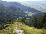
Osolnik is an 858 m high mountain located south of Škofja Loka and west of Medvode. From the top, where the Church of St. Mohor and Fortunatus st...
1 h 30 min |
 | Mlinše - Zasavska Sveta gora
Zasavska Sveta gora is a popular excursion point located between Litija and Izlaki. From the top, where the parish church of the Nativity of the ...
1 h 30 min |
 | Vidrga - Zasavska Sveta gora (on forest footpath)
Zasavska Sveta gora is a popular excursion point located between Litija and Izlaki. From the top, where the parish church of the Nativity of the ...
1 h 30 min |
| Vidrga - Zasavska Sveta gora (on a cart track)
Zasavska Sveta gora is a popular excursion point located between Litija and Izlaki. From the top, where the parish church of the Nativity of the ...
1 h 30 min |
 | Mala voda - Kožljek
Kožljek is a 788 m high peak located to the west of Koreno, specifically above the village of Samotorica. From the top, where there are a few ben...
1 h 15 min |
 | Mala voda - Koreno
Koreno also Koreno is a 729 m high hill located north of Horjul. From the top, where there is a large cross, the Church of St. Mohorj and Fortuna...
1 h 15 min |
 | Water storage Žegnani studenec - Vaško
Vaško is a little-known mountain in the south-eastern ridge of Dobrča. From the top there is a beautiful view towards Jelovica and the Julian Alp...
1 h 5 min |
 | Hotovlja - Bukov vrh (by road)
Bukov vrh, on which the Church of the Sorrowful Mother of God stands, is located in the north-western part of the Polhograje hills. From the top ...
1 h 30 min |
 | Podgorje - Kojnik (via hunting cottage)
Kojnik is a partially vegetated peak located in the southern part of the Podgorje Karst near the Slovenian-Croatian border. From the top of the s...
1 h 30 min |
 | Planina - Petričev hrib
Petričev hrib is the peak north of Postojna and west of Mountain pasture. From the summit, which has a registration box, there is a beautiful vie...
1 h 30 min |
| Planina (Dolnja Planina) - Petričev hrib (via Zavrtniki)
Petričev hrib is the peak north of Postojna and west of Mountain pasture. From the summit, which has a registration box, there is a beautiful vie...
1 h 35 min |
| Planina (Dolnja Planina) - Petričev hrib (via Sv. Duh)
Petričev hrib is the peak north of Postojna and west of Mountain pasture. From the summit, which has a registration box, there is a beautiful vie...
1 h 35 min |
 | Tržič - Kamnek (Milanova pot)
Kamnek (Kamnik on maps, but also Kamnjek) is a scenic peak above Tržič....
1 h 5 min |
 | Tržič (Slap) - Kamnek (via Dobrivc)
Kamnek (Kamnik on maps, but also Kamnjek) is a scenic peak above Tržič....
1 h |
 | Podpeč - Grmada on Mala gora
Grmada (also Grmada nad Ortnek) is an 887 m high peak located above the village of Vrh pri Poljanah in the Mala Gora mountain range. Just a few m...
1 h 35 min |
| Novi Lazi - Livoldski vrh
Livoldski vrh is a forested peak located in the south-eastern part of Stojna. The summit has a registration box and a stamp....
1 h 10 min |
 | Planina - Grmada (Planinska gora)
Grmada is an 873m high peak rising west of Planinsko Polje. The summit is overgrown, but from the lookout point just below the summit we have a b...
1 h |
 | Planina (Dolnja Planina) - Grmada (Planinska gora) (via Zavrtniki)
Grmada is an 873m high peak rising west of Planinsko Polje. The summit is overgrown, but from the lookout point just below the summit we have a b...
1 h 5 min |
| Planina (Dolnja Planina) - Grmada (Planinska gora) (via Sv. Duh)
Grmada is an 873m high peak rising west of Planinsko Polje. The summit is overgrown, but from the lookout point just below the summit we have a b...
1 h 5 min |
 | Olševek - Štefanja gora (via Apnišče)
Štefanja gora on which the Church of St Stephen stands, is located above Cerkly in Gorenjska. Just 10 metres below the summit, the Pr'Mežnarju ex...
1 h 15 min |
 | Preddvor - Štefanja gora (on footpath)
Štefanja gora on which the Church of St Stephen stands, is located above Cerkly in Gorenjska. Just 10 metres below the summit, the Pr'Mežnarju ex...
1 h 20 min |
 | Poljana - Smolnik
Smolnik is a steep 1075 m high peak - a solitary peak below Valvasor's house, rising above the Zavrh (Završnica) valley, with a view of Hochstuhl...
1 h 15 min |
 | Poljana - Smolnik (steep path)
Smolnik is a steep 1075 m high peak - a solitary peak below Valvasor's house, rising above the Zavrh (Završnica) valley, with a view of Hochstuhl...
1 h |
 | Polhov Gradec (Božna) - Mala Grmada (via Sveta Uršula)
Mala Grmada is an 853 m high peak located south-west of the slightly higher Polhograjska Grmada. From the top, you have a beautiful view over the...
1 h 10 min |
 | Bohinjska Češnjica - Rudnica
Rudnica is a scenic mountain located between the Lower and Upper Bohinj Valley. From the top, where there is a registration box with a stamp and ...
1 h 30 min |
| Srednja vas (Senožeta) - Rudnica
Rudnica is a scenic mountain located between the Lower and Upper Bohinj Valley. From the top, where there is a registration box with a stamp and ...
1 h 30 min |
 | Nemilje - Sveti Mohor (Zabrekve)
The Church of St. Mohor is situated on a 952 m high hill, between Zgornja Besnica and Selce. From the church, or its immediate surroundings, we h...
1 h 20 min |
 | Nemilje - Sveti Mohor (Zabrekve) (via Prevoje)
The Church of St. Mohor is situated on a 952 m high hill, between Zgornja Besnica and Selce. From the church, or its immediate surroundings, we h...
1 h 35 min |
 | Njivica - Sveti Primož in Felicijan (Jamnik)
The Church of St. Primož and Felicijan on Jamnik, is situated on a scenic grassy ridge rising between Kropa and Podblica. From the church or its ...
1 h 10 min |
 | Brezovica - Sveti Primož in Felicijan (Jamnik)
The Church of St. Primož and Felicijan on Jamnik, is situated on a scenic grassy ridge rising between Kropa and Podblica. From the church or its ...
1 h 20 min |
| Češnjica pri Kropi - Sveti Primož in Felicijan (Jamnik) (via Berigla)
The Church of St. Primož and Felicijan on Jamnik, is situated on a scenic grassy ridge rising between Kropa and Podblica. From the church or its ...
1 h 20 min |
 | Ribenski most - Tolsti vrh (Talež)
Tolsti vrh is an 883 m high hill located south of Bled, above the Talež Hunting Lodge. The summit, which descends steeply towards the Sava Bohinj...
1 h 15 min |
 | Selski most - Tolsti vrh (Talež)
Tolsti vrh is an 883 m high hill located south of Bled, above the Talež Hunting Lodge. The summit, which descends steeply towards the Sava Bohinj...
1 h 15 min |
 | Trojane - Lipovec
Lipovec is an 848 m high peak located above the pastures of Lipovec. In good weather, the summit offers a view of Posavsko hribovje, Kum, Menino ...
1 h 30 min |
 | Jasen - Ahac
Ahac or St. Ahac is a 799 m high peak located east of Ilirska Bistrica. The summit, which is home to a registration box, a cross and the ruins of...
1 h |
| Vrbovo - Ahac
Ahac or St. Ahac is a 799 m high peak located east of Ilirska Bistrica. The summit, which is home to a registration box, a cross and the ruins of...
1 h |
 | Tržič (Čegelše) - Veliki vrh above Završnik
Veliki vrh above Završnik is a 968 m high mountain located in the Pirmance ridge, north to north-east of Tržič. From the grassy summit, where the...
1 h 20 min |
 | Brezje nad Kamnikom - Vovar (western way)
An obscure hill in front of the Kamnik mountains. Recently covered by storms, it has been covered with wood harvesting tracks.There is also a sma...
1 h |
| Brezje nad Kamnikom - Vovar (northern way)
An obscure hill in front of the Kamnik mountains. Recently covered by storms, it has been covered with wood harvesting tracks.There is also a sma...
1 h |
 | Babni Vrt - Gradišče (Pustinjak) (through forest and past Sveti Lovrenc)
Gradišče or Pustinjak (also Gradišče above Bašlje) is an 871-metre-high peak located above the Belica stream, which in turn is below the 2132-met...
1 h 15 min |
 | Col - Špiček (Špečk)
Špiček (locals call it Špečk) is a peak located north to north-east of Cola. On the summit is a cross in honour of St Hubert and commemorating th...
55 min |
 | Col - Špiček (Špečk) (via Križna gora)
Špiček (locals call it Špečk) is a peak located north to north-east of Cola. On the summit is a cross in honour of St Hubert and commemorating th...
1 h 10 min |
 | Col - Križna gora above Col (via Špiček)
Križna gora is a 957 m high peak located north of Cola. The summit, which is forested on the north side, offers a beautiful view to the east, sou...
1 h 10 min |
 | Col - Križna gora above Col
Križna gora is a 957 m high peak located north of Cola. The summit, which is forested on the north side, offers a beautiful view to the east, sou...
55 min |
 | Adergas - Apnišče (via Šterna)
Apnišče is a 740 m high mountain located between Možjanca and Štefanja gora. It is the highest point of the Šenčur municipality. There is a bench...
1 h |
 | Preddvor - Apnišče (on footpath)
Apnišče is a 740 m high mountain located between Možjanca and Štefanja gora. It is the highest point of the Šenčur municipality. There is a bench...
1 h 15 min |
 | Blejska Dobrava (cemetery) - Hom pri Bledu (via Katarina)
Hom is an 834 m high hill that rises north above the villages Zasip and Podhom near Bled, or south of the village Blejska Dobrava near Jesenice. ...
1 h 25 min |
 | Blejska Dobrava (cemetery) - Hom pri Bledu (on east slope)
Hom is an 834 m high hill that rises north above the villages Zasip and Podhom near Bled, or south of the village Blejska Dobrava near Jesenice. ...
1 h 5 min |
 | Poljane (Spodnje Gorje) - Boršt (by road)
Boršt is a 931 m high vegetated peak located 4 km north-west of Bled, or east of the Mežakla plateau. Between it and the neighbouring peak of Hom...
1 h |
 | Trate (Blejska Dobrava) - Boršt
Boršt is a 931 m high vegetated peak located 4 km north-west of Bled, or east of the Mežakla plateau. Between it and the neighbouring peak of Hom...
1 h |
 | Ukova (Jesenice) - Mirca (via Pekova plan'ca)
Mirca (dialect Merca) is one of the peaks of the southern Karavanke mountain range with an altitude of 1025 m. It rises north above the centre of...
1 h 20 min |
 | Murova - Mirca
Mirca (dialect Merca) is one of the peaks of the southern Karavanke mountain range with an altitude of 1025 m. It rises north above the centre of...
1 h 10 min |
 | Kokra (resting place Kokra-sotočje) - Skutman
Skutman is a lesser-known peak located above the left bank of the Kokra River and north of Štefanje Gora. The summit is marked by a metal sign wi...
1 h 10 min |
 | Bele Vode (Kovač) - Sveti Križ above Bele Vode (on south ridge)
Sveti Križ is a scenic mountain located above Beli Voda. From the top, which is home to a number of church buildings and a conversion tower, we h...
1 h 10 min |
 | Mežica - Andrejev vrh (by cart track)
Andrejev vrh is a forested peak located between Mežica and Lesa. There is a bench on the top and a registration box with a registration book....
1 h 15 min |
| Mežica - Andrejev vrh (past the chapel)
Andrejev vrh is a forested peak located between Mežica and Lesa. There is a bench on the top and a registration box with a registration book....
1 h 20 min |
| Leše - Andrejev vrh (via Leše churches and via chapel)
Andrejev vrh is a forested peak located between Mežica and Lesa. There is a bench on the top and a registration box with a registration book....
1 h 35 min |
| Leše - Andrejev vrh (past Leše churches and on cart track)
Andrejev vrh is a forested peak located between Mežica and Lesa. There is a bench on the top and a registration box with a registration book....
1 h 30 min |
 | Selca - Sleme (Površnica)
Sleme is a scenic peak located between Rudni, Dražgoše and Lajša. The summit, where the transmitters are located, offers a beautiful view of the ...
1 h 35 min |
| Železniki - Sleme (Površnica) (via Štalca)
Sleme is a scenic peak located between Rudni, Dražgoše and Lajša. The summit, where the transmitters are located, offers a beautiful view of the ...
1 h 35 min |
 | Selca - Sveti Križ above Selca
The Sveti Križ above Selca church is situated on a lookout point, which offers a beautiful view over part of the Škofjeloško hribovje....
1 h 15 min |
| Železniki - Sveti Križ above Selca (via Štalca)
The Sveti Križ above Selca church is situated on a lookout point, which offers a beautiful view over part of the Škofjeloško hribovje....
1 h 15 min |
 | Prevalje - Brinjeva gora (above Prevalje) (via Stations of the Cross)
Brinjeva gora is a popular excursion spot for Prevalj inhabitants, located between the Meža River and the Zelenbreški brok. At the top of the hil...
1 h |
| Prevalje - Brinjeva gora (above Prevalje) (south path)
Brinjeva gora is a popular excursion spot for Prevalj inhabitants, located between the Meža River and the Zelenbreški brok. At the top of the hil...
1 h |
| Ravne na Koroškem - Brinjeva gora (above Prevalje)
Brinjeva gora is a popular excursion spot for Prevalj inhabitants, located between the Meža River and the Zelenbreški brok. At the top of the hil...
1 h 10 min |
 | Senično - Planica (Paragliding site Gozd) (gentle path)
Planica is a 926-metre-high peak located above the village of Gozd. From the top, where the JPK Kriška gora hut is located, we have a beautiful v...
1 h 15 min |
| Senično - Planica (Paragliding site Gozd) (steep path)
Planica is a 926-metre-high peak located above the village of Gozd. From the top, where the JPK Kriška gora hut is located, we have a beautiful v...
1 h 10 min |
| Pristava - Planica (Paragliding site Gozd)
Planica is a 926-metre-high peak located above the village of Gozd. From the top, where the JPK Kriška gora hut is located, we have a beautiful v...
1 h 20 min |
 | Rudnik pri Radomljah - Tolsta gora
Tolsta gora is a 734-metre-high mountain located above Vrhpolje near Kamnik. From the top, where cairn stands, there is no better view, thanks to...
1 h 25 min |
 | Rudnik pri Radomljah - Vrtače (via Lancar)
Vrtače is a 758-metre-high peak located above the village of Zgornje Palovče. The peak is covered with forest, but the clearing slightly below th...
1 h 30 min |
 | Dravograd (Meža) - Sveti Danijel (above Trbonje)
The Church of St. Danijel is located on the outskirts of the village of St. Danijel, just above Trbonyi. From the church we have a beautiful view...
1 h 30 min |
 | Škofja Loka - Vrh soteske (Križna gora)
Vrh soteske is a 735 m high peak located in the south-western part of Križna Gora. There is no better view from the top, which is covered by fore...
1 h 25 min |
| Vešter - Vrh soteske (Križna gora)
Vrh soteske is a 735 m high peak located in the south-western part of Križna Gora. There is no better view from the top, which is covered by fore...
1 h 15 min |
 | Šentviška Gora - Črvov vrh
Črvov vrh, also known as Črvov grič, is the highest peak of the Šentviška plateau, rising above the right bank of the Idrijca and the left bank o...
1 h 10 min |
 | Šentviška Gora - Bukovski vrh
Bukovo vrh (918 m) is located above the settlement Bukovo Vrh, more precisely above the homestead at Pircu.From the grassy summit we have a beaut...
1 h 30 min |
 | Hotavlje - Vrh Slajke
Vrh Slajke is a 790-metre-high hill located above Hotavlje, on the right bank of the Kopačnice River. From the top, where the antenna tower stand...
1 h 15 min |
| Hotavlje - Vrh Slajke (via Bela)
Vrh Slajke is a 790-metre-high hill located above Hotavlje, on the right bank of the Kopačnice River. From the top, where the antenna tower stand...
1 h 30 min |
| Podgora - Vrh Slajke
Vrh Slajke is a 790-metre-high hill located above Hotavlje, on the right bank of the Kopačnice River. From the top, where the antenna tower stand...
1 h 25 min |
 | Ledinica - Krog (Ledinski grič)
Krog is a 940 m high peak located on the western part of the Ledinski grič ridge, which is situated between the Jerešča and Ledinščica watercours...
1 h 15 min |
 | Selca - Lepo brdo
Lepo brdo is a 778-metre-high hill located above the settlements of Selca and Studeno....
1 h |
 | Zreče (Terme Zreče) - Golek (steep path)
Golek is a 769-metre-high peak located north-west of Zreče. At the top there is a registration box with a registration book, a stamp and a bench,...
1 h 20 min |
 | Übelbach - Schankkogel
...
1 h 30 min |
 | Übelbach - Schankkogel (strma pot)
...
1 h 30 min |
 | Deutschfeistritz - Parmaseggkogel (čez Kugelberg)
...
1 h 15 min |