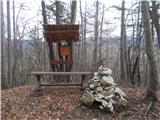
 | Topol - Sveti Jakob
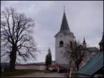
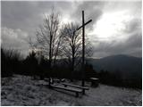
The Church of St James is located on a hill north of the village of Topol near Medvode. From the top, where there is a registration box with a st...
40 min |
| Topol - Sveti Jakob (via homestead Na Vihri)
The Church of St James is located on a hill north of the village of Topol near Medvode. From the top, where there is a registration box with a st...
45 min |
 | Tourist farm Gonte - Tošč
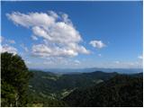
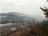
Tošč, which became the highest peak of Polhograjsko hribovje decades ago when Pasja ravan was lowered by 9 m by the Yugoslav army, is located nor...
45 min |
 | Breznica - Lubnik
Lubnik is a 1025 m high mountain rising steeply to the west of Škofja Loka. From the summit, on which the mountain lodge stands, you can enjoy a ...
40 min |
 | Zapotok - Kurešček
Kurešček is an 826 m high peak located south of Ig and south-west of Želimlje. The view from the top, on which the church stands, is not possible...
45 min |
 | Javornik - Sveti Jošt above Kranj
Sveti Jošt above Kranj, is a hill located to the west of the slightly lower Šmarjetna Gora. From the top, where the Church of St. Jošto and the J...
40 min |
| Čepulje - Sveti Jošt above Kranj
Sveti Jošt above Kranj, is a hill located to the west of the slightly lower Šmarjetna Gora. From the top, where the Church of St. Jošto and the J...
45 min |
 | Rovišče - Zasavska Sveta gora (by road)
Zasavska Sveta gora is a popular excursion point located between Litija and Izlaki. From the top, where the parish church of the Nativity of the ...
35 min |
 | Ljubljanica - Kožljek
Kožljek is a 788 m high peak located to the west of Koreno, specifically above the village of Samotorica. From the top, where there are a few ben...
45 min |
 | Praproče - Mali vrh
To the west of Polhov Gradec, between the rivers Mala voda and Velika Božna, is a 708-metre-high hill called Mali vrh. From the grassy summit, wh...
35 min |
 | Gabrje - Limbarska gora (footpath)
Limbarska gora is located north-east of Moravce. From the top there is a beautiful view of the surrounding peaks and in good weather you can also...
45 min |
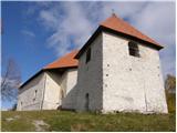
 | Smrečje - Vrh Svetih Treh Kraljev (by road)
The Church of the Holy Three Kings is situated on a lookout above the village of Vrh Svetih Treh kraljev. From the top, which has an observation ...
45 min |
 | Smrečje - Vrh Svetih Treh Kraljev (footpath)
The Church of the Holy Three Kings is situated on a lookout above the village of Vrh Svetih Treh kraljev. From the top, which has an observation ...
40 min |
| Smrečje - Vrh Svetih Treh Kraljev (via Jereb)
The Church of the Holy Three Kings is situated on a lookout above the village of Vrh Svetih Treh kraljev. From the top, which has an observation ...
45 min |
| Račevsko jezero - Vrh Svetih Treh Kraljev
The Church of the Holy Three Kings is situated on a lookout above the village of Vrh Svetih Treh kraljev. From the top, which has an observation ...
45 min |
 | Kuren - Koča na Planini nad Vrhniko
Planina above Vrhnika is for hers inhabitants something like Šmarna gora for inhabitants of Ljubljana. It is 733 metres high and is reachable fro...
45 min |
 | Veliki Ločnik - Sveti Ahac
The Sveti Ahac church is located on a peak called Gora above the villages of Mali and Veliki Ločnik near Turjak. From the top, which has a regist...
30 min |
 | Lanišče - Janče
Janče is a 792-metre-high peak located between the Sava River and the valley of the Besnica Stream. From the top, where the mountain lodge stands...
30 min |
 | Katarija - Sveti Miklavž above Sava
The Church of St Nicholas is situated on a hill south of Moravče. From the top you can enjoy a beautiful view of the nearby Limbarska gora, and t...
45 min |
 | Križevska vas - Cicelj (via farm Buven)
Cicelj is a forested peak located between Moravče and the village of Senožeti. There is no view from the top, which has a bench and a registratio...
45 min |
 | Križevska vas - Cicelj
Cicelj is a forested peak located between Moravče and the village of Senožeti. There is no view from the top, which has a bench and a registratio...
40 min |
 | Ledine - Sivka
Sivka is a forested peak located west of Žiri and north of Idrija. On the summit there is a stamp of the Slovenian mountain trail and a registrat...
45 min |
 | Dobrič (Vedet) - Gora Oljka (via Rogeljšek)
Gora Oljka is a hill located east of Šmartno ob Paki. On the top stands the Church of the Holy Cross, which was built in the mid-18th century. Ju...
40 min |
 | Lom - Koča na Kamnem griču
The cottage is located on Kamný hill, a scenic peak rising south-west of Sodražica. The grassy summit, surrounded by forest, offers a beautiful v...
45 min |
 | Blečji vrh - Kucelj
Kucelj is a 748m high peak located north of Višnja gora. From the top of the peak there is a small geodetic tower with a stamp, which offers a be...
45 min |
 | Velika vrata - Mala Plešivica
Mala Plešivica, which is higher than the neighbouring Velika Plešivica, is a scenic peak located to the west of the village of Golac on the borde...
35 min |
 | Dule - Kamen vrh
Kamen vrh is a scenic peak located on the northern outskirts of Mala Gora. From the top, surrounded by low bushes, there is a beautiful view of p...
45 min |
 | Ortnek - Ortnek Castle
Ortnek Castle is located on the Veliki Žrnovec escarpment, which rises south-west of the village of Ortnek. Today, only ruins remain of the castl...
40 min |
 | Sveta Trojica - Murovica
Murovica is a popular excursion point, accessible from the Posavina side, Domžale or from the Moravška valley. There is a bench and a registratio...
45 min |
 | Križevska vas - Murovica
Murovica is a popular excursion point, accessible from the Posavina side, Domžale or from the Moravška valley. There is a bench and a registratio...
45 min |
 | Zavrate - Govško brdo
Govško brdo is an 811m high hill located west of the village of Huda jama above Laško. From the top of the hill, where the registration box and s...
40 min |
 | Jesenice (Ukova) - Kalvarija above Jesenice
Calvary is a popular point or peak above the town of Jesenice, known either as a kind of short "pilgrimage" route for the faithful, or as a short...
25 min |
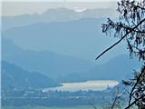
 | Velika Zaka (Bled) - Mala Osojnica (along Ojstrica)
Mala Osojnica is a 691 m high peak rising above Lake Bled near Velika Zaka. It is a favourite spot for photographers, as all the famous panoramas...
40 min |
 | Mislinja - Črepič
Črepič is a 798 m high peak located to the west of Mislinja. As the summit is forested, there is no view from the summit, but it is so extensive ...
45 min |
 | Begunje - Goli vrh (Cemarovnik)
Goli vrh or Begunjski Cemarovnik is an 816 m high mountain located in the south-eastern part of Menišija. From the top, on which stands a large c...
30 min |
 | Smrečje - Lavrovec
Lavrovec is an 890 m high peak located between Horjul and Žirmi. From the top, where the solar irradiance meter is located (official measuring po...
40 min |
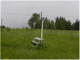
 | Dom na Govejku - Gontarska planina
Gontarska planina is an 894 m high mountain located between Osolnik and Tosce. From the top, where there are two benches, we have a beautiful vie...
35 min |
 | Belo - Goljek
Goljek is an 809 m high peak located east of Polhograjska Grmada. The view from the summit, which is home to the remains of a former watchtower o...
40 min |
| Topol - Goljek (on west ridge)
Goljek is an 809 m high peak located east of Polhograjska Grmada. The view from the summit, which is home to the remains of a former watchtower o...
30 min |
 | Rakitna - Rotovc
Rotovc is a 964 m high peak located northeast of Rakitna. From the top, where a wooden bench stands, we have a beautiful view towards the already...
30 min |
 | Trebež (Jesenice) - Kozjek (on east ridge)
Kozjek is a 766 m high, easily accessible, ridge-like peak of the Jelenkamn fothills, which makes it part of the southern Karavanke fothills, and...
30 min |
 | Čepulje - Špičasti hrib
Špičasti hrib (Špičasti vrh on maps) is an 837 m high peak located to the west of Sveti Jošto above Kranj. There is no view from the top, which h...
40 min |
 | Hunting sports association Vinska Gora - Vinska gora
Vinska gora, marked on some maps as neighbouring Temnjak, is an 806 m high hill located north-west of Dobrnež and north-east of Vinská Gora. The ...
40 min |
 | Planinski dom pod Ježo - Ježa
Ježa is a 949 m high peak located west of Volč, on the slopes of Kolovrat. From the top, where there is a registration box with a registration bo...
30 min |
 | Planinski dom pod Ježo - Deveti konfin (survey point 942)
Deveti konfin is a 930 m high peak in the Kolovrat mountain range, located between Ježa and Očno. There is no view from the summit, where a small...
45 min |
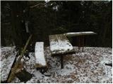
 | Mojstrana - Grančišče (south path)
Grančišče (also Grančiše) is a small precipitous peak rising west to south-west of Mojstrana. From the top, where there is a bench and a table, w...
25 min |
 | Zavrh pri Trojanah - Reber
Reber is an 878 m high peak located south-west of Trojany. On the summit, which has a registration box with a registration book and a stamp, ther...
45 min |
 | Zagorje - Šilentabor
Šilentabor is a 751 m high peak located just above the village of the same name. From the top, near which there is also a bench and a registratio...
35 min |
 | Črne njive - Ahac
Ahac or St. Ahac is a 799 m high peak located east of Ilirska Bistrica. The summit, which is home to a registration box, a cross and the ruins of...
40 min |
 | Prelože pri Lokvi - Veliko Gradišče
Veliko Gradišče is a 742 m high peak located south of the village of Lokev in the Karst and east of Kokoši. From the top, on which stands a concr...
45 min |
 | Bašelj - Gradišče (Pustinjak)
Gradišče or Pustinjak (also Gradišče above Bašlje) is an 871-metre-high peak located above the Belica stream, which in turn is below the 2132-met...
45 min |
 | Možjanca - Apnišče
Apnišče is a 740 m high mountain located between Možjanca and Štefanja gora. It is the highest point of the Šenčur municipality. There is a bench...
35 min |
 | Poljana (Završnica) - Mali vrh above Završnica
Mali vrh, which measures 863 metres, is one of the peaks of the Breznik Peci (also Reber) ridge, with the Zavrh valley to the north and the upper...
35 min |
 | Rebrca / Rechberg - Rokov vrh / Rochusberg
Rokov vrh is an 880 m high peak (according to some data 817 m) located between the settlements of Suha / Zauchen, Rebrca / Rechberg and Podkraj /...
40 min |
 | Škalske Cirkovce - Skalni vrh (Vodemla)
Skalni vrh is the highest peak of Vodemla Hill, rising above Paka pri Velenju on one side and the Velenje basin on the other. On the way along th...
35 min |
 | Lipovnik - Šteharski vrh (Šteharnikov vrh)
Šteharski or Šteharnikov vrh, also Črneška gora, is a 1018-metre-high mountain located in the south-eastern part of Strojna, a mountain range bet...
45 min |
 | border crossing Remšnik - Sveti Pankracij (Radelca)
The Church of St Pancras on Radelca is located on the border ridge between Slovenia and Austria, but since 1966, following an inter-state agreeme...
25 min |
 | Škalske Cirkovce - Lubela (by road)
Lubela is a hill at Velenje, rising north above the Šaleška dolina and belonging to the Šentviška hills or the wider area of the Graška Gora.On t...
45 min |
 | Onek - Lovski vrh
Lovski vrh is a 830 m high peak located above the settlements of Onek and Mačkovec in the municipality of Kočevje. From the top, which is home to...
45 min |
 | Zajasovnik - del (Strmce, chapel) - Jasovnik (Motnik tourist trail)
Jasovnik is a hill better known to all of us as the A1 motorway tunnel. The hill is located near Trojany. It has two peaks: the Little Jasovnik a...
45 min |
| Stružnica - Kuželjska stena
Kuželjska stena rises majestically above the village of Kuželj in the Kolpa valley. It is a rise in a fault that winds above the upper Kolpa vall...
45 min |
 | Sedlo nad Lohačo - Špilnik (lower path)
Špilnik is a less visited but very scenic peak on the south side of Hrušice, specifically above the village of Strmca. It has a central position ...
30 min |
 | Planina pri Sevnici - Sveti Križ (above Planina pri Sevnici) (via Pravljični gozd)
The Church of the Holy Cross is located above Planina pri Sevnici, near the settlement of Šentvid at Mountain pasture. From the top, you have a b...
28 min |
 | Smiljan - Krčmar (Way of the Cross)
...
45 min |
| Smiljan - Krčmar (on marked path)
...
40 min |
 | Road on Bjelsko - Stožac
...
30 min |