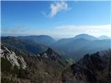
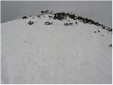
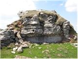
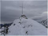
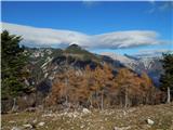
 | Ljubelj - Vrh Ljubeljščice (Triangel)
Above the Zelenica ski area more precisely above the Triangel ski lift lies a 1704 m high peak that is the highest point of the Ljubeljščica ri...
1 h 50 min |
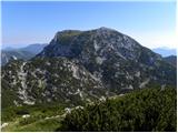
 | Dom pod Storžičem - Veliki Javornik (Ženiklovec)
Veliki Javornik (also known as Ženiklovec) is a 1716 m high peak located between Storžič and Stegovnik. From the grassy summit with its registrat...
1 h 50 min |
| Planina Vetrh - Veliki Javornik (Ženiklovec)
Veliki Javornik (also known as Ženiklovec) is a 1716 m high peak located between Storžič and Stegovnik. From the grassy summit with its registrat...
1 h 30 min |
 | Planina Dol - Rzenik (west path)
Rzenik is a grassy peak surrounded by dwarf pines that drops precipitously into the Kamniška Bela valley. From the summit, in clear weather, a wo...
1 h 40 min |
 | Planina Dol - Rzenik (east path)
Rzenik is a grassy peak surrounded by dwarf pines that drops precipitously into the Kamniška Bela valley. From the summit, in clear weather, a wo...
1 h 40 min |
 | Kališe - Kranjska reber
Kranjska reber, also known as Vrh Kašne planine (1435 m), is a mountain of volcanic origin. From the summit, which has a registration box with a ...
1 h 30 min |
| Volovljek - Kranjska reber (on unmarked path)
Kranjska reber, also known as Vrh Kašne planine (1435 m), is a mountain of volcanic origin. From the summit, which has a registration box with a ...
1 h 15 min |
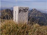
 | Pod Krnico - Plešivec
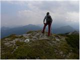
Plešivec is an 1801 m high peak situated south of the eastern part of Košuta. From the summit, where a border marker stands, there is a beautiful...
1 h 20 min |
 | Pod Krnico - Mala Košuta
Mala Košuta (in German: Kleine Koschuta) is a 1740 m high peak located at the far eastern end of the Košuta ridge. From the summit, which drops s...
1 h 15 min |
 | Planina Podvežak - Deska (Veža) (snowy approach)
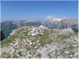
Deska is a panoramic peak located in the heart of the Dleskovška planota plateau, also known as Veža. From the summit, where a large cairn stands...
1 h 30 min |
 | Hunting cottage Na Brežičih - Deska (Veža)
Deska is a panoramic peak located in the heart of the Dleskovška planota plateau, also known as Veža. From the summit, where a large cairn stands...
1 h 30 min |
 | Planina Podvežak - Deska (Veža)
Deska is a panoramic peak located in the heart of the Dleskovška planota plateau, also known as Veža. From the summit, where a large cairn stands...
1 h 30 min |
 | Planina Podvežak - Tolsti vrh (Veža) (snowy approach)
Tolsti vrh is a 1985 m high mountain located in the heart of the Dleskovška planota plateau, known as Veža. From the summit, which is covered wit...
1 h 30 min |
 | Hunting cottage Na Brežičih - Tolsti vrh (Veža) (via Deska)
Tolsti vrh is a 1985 m high mountain located in the heart of the Dleskovška planota plateau, known as Veža. From the summit, which is covered wit...
1 h 45 min |
| Planina Podvežak - Tolsti vrh (Veža)
Tolsti vrh is a 1985 m high mountain located in the heart of the Dleskovška planota plateau, known as Veža. From the summit, which is covered wit...
1 h 30 min |
 | Planina Vetrh - Bela peč (via cottage Pr Zdravc)
The mountain, known mainly among climbers, is located north of Storžič on the slopes of Konjščica. From the summit there is a beautiful view of t...
1 h 15 min |
 | Dom Pristava in Javorniški Rovt - Ptičji vrh
Ptičji vrh is a 1550-metre-high mountain located between Struška and Golica. From the summit, which lies on the border between Slovenia and Austr...
1 h 45 min |
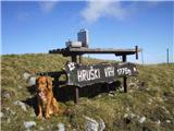
 | Martinčev Rovt - Rosenkogel/Hruški vrh
Hruški vrh is a 1776-metre-high mountain located between Dovška Baba and the lesser-known Klek. From the summit, where there is a small chapel de...
1 h 45 min |
 | Rogarjev rovt - Rosenkogel/Hruški vrh (via Hruška planina)
Hruški vrh is a 1776-metre-high mountain located between Dovška Baba and the lesser-known Klek. From the summit, where there is a small chapel de...
1 h 35 min |
 | Rogarjev rovt - Rosenkogel/Hruški vrh (via Rožca)
Hruški vrh is a 1776-metre-high mountain located between Dovška Baba and the lesser-known Klek. From the summit, where there is a small chapel de...
1 h 40 min |
 | Martinčev Rovt - Klek
Klek is a 1753-metre-high mountain located between Hruški vrh and the better-known Golica. The summit, on the border between Slovenia and Austria...
1 h 35 min |
 | Rogarjev rovt - Klek
Klek is a 1753-metre-high mountain located between Hruški vrh and the better-known Golica. The summit, on the border between Slovenia and Austria...
1 h 30 min |
 | Železnica - Techantinger Mittagskogel (Trupejevo poldne)
The mountain is located on the border with Austria above Gozd Martuljek. From the bare summit, there is a beautiful view of the Julian Alps and t...
1 h 15 min |
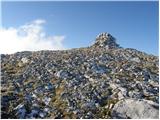 | Planina Ravne - Dleskovec (by southern mountainside)
Dleskovec is a panoramic mountain on the eastern side of the Dleskovška plateau, which is named after it. A very large cairn stands on the summit...
1 h 40 min |
 | Kozarnice - Srednji Golak (unmarked eastern way)
Srednji Golak is located between Mali and Veliki Golak on the plateau of Trnovski gozd above Predmeja. The peak is covered with dwarf pines, and ...
1 h 45 min |
 | Rifugio Nordio - Gozman (via Lom)
Gozman is a peak between the Bistrica mountain pasture and the Nordio mountain hut, near Ojstrnik (Osternig) in the Carnic Alps. As the summit is...
1 h 45 min |
| Rifugio Nordio - Gozman (direct way)
Gozman is a peak between the Bistrica mountain pasture and the Nordio mountain hut, near Ojstrnik (Osternig) in the Carnic Alps. As the summit is...
1 h 40 min |
| Rifugio Nordio - Gozman (via Sella Pleccia)
Gozman is a peak between the Bistrica mountain pasture and the Nordio mountain hut, near Ojstrnik (Osternig) in the Carnic Alps. As the summit is...
1 h 30 min |
 | Zadnji travnik - Govca (Olševa) (hunting path)
Govca is the highest peak of the Olševa range, rising above Koprivna, Solčava, and Remšenik (Remšenik/Remschenig is a valley on the Austrian side...
1 h 45 min |
 | Dolinza Alm / Planina Dolnica - Sagranberg/Monte Sagran
Konjščica / Sagranberg / Monte Sagran is a panoramic mountain with no marked trail leading to the summit. The grassy peak drops steeply southward...
1 h 30 min |
 | Jezero Sobote / Stausee Soboth - Huhnerkogel/Košenjak (on unmarked path)
Košenjak is located north of Dravograd and the Drava River on the border with neighbouring Austria. Access to Košenjak is possible on foot or by ...
1 h 40 min |
 | Planina Lom - Kobilja glava
Kobilja glava is a 1,475-meter-high peak located east of Tolmin. From the summit, where a cross stands, there is a beautiful view of Krn, the ran...
1 h 15 min |
 | Koča na planini Stador - Jalovnik
Jalovnik is a grassy peak located southeast of the slightly higher Kobilja glava. From the summit, which has a summit logbook, there is a nice vi...
1 h 30 min |
| Planina Lom - Jalovnik
Jalovnik is a grassy peak located southeast of the slightly higher Kobilja glava. From the summit, which has a summit logbook, there is a nice vi...
1 h 30 min |
 | Korensko sedlo - Jerebikovec/Rawikautz
Jerebikovec is a 1621 m high mountain rising east of Korensko sedlo. From its partly grassy summit, surrounded by forest, there is no view....
1 h 20 min |
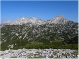
 | Erjavčeva koča na Vršiču - Prednje Robičje
Prednje Robičje is a 1,941-meter-high mountain situated in the ridge between the Mala Pišnica and Velika Pišnica valleys. From the summit, where ...
1 h 10 min |
 | Ljubelj - Spodnji Plot
Spodnji Plot is a 1,682 m high mountain located south of the slightly higher Vrh Ljubeljščice (Triangel). From the precipitous summit, popular ma...
1 h 45 min |
 | Križovec - Mala Golica
Mala Golica is a less distinct peak located east of Krvavka. From its grassy summit, there is a nice view of the Dravska dolina, Struško, parts o...
1 h 30 min |
 | Makekova Kočna - Visoki vrh above Jezersko
Visoki vrh is a 1459-meter-high mountain in the ridge between Makekovo Kočna and Ravenska Kočna. From the summit, there is a fine view toward Koč...
1 h 30 min |
 | Makekova Kočna - Javornik above Jezersko
Javornik is a forested peak between the valleys of Ravenska Kočna and Makekove Kočna. There is no view from the summit due to the trees, but near...
1 h 45 min |
 | Poden / Bodental - Požgani rob
Požgani rob is a 1,513-meter-high mountain north of Rjavca. The summit is surrounded by forest, so there is no good view from it, but a nice pano...
1 h 10 min |
 | Planina Loka - Kup (on Raduha)
Kup is a 1,808-meter-high peak situated on the far northeastern part of Raduha. From the summit, where a cross stands, a beautiful view opens up ...
1 h 20 min |
 | Ski hotel Vogel - Vrh Dlani
Vrh Dlani is a lesser-known peak in the ridge of the Lower Bohinj Mountains, more precisely between Šija and Vogel. From the grassy summit, which...
1 h 40 min |
 | Sele pri Cerkvi / Zell - Pfarre - Mejnik
Mejnik is a 1517-meter-high peak on the Austrian side of the Karawanks, more precisely in a side ridge of Košuta. On the forested summit is a bou...
1 h 55 min |
 | Tolminske Ravne - Grušnica (via planina na Kalu)
Grušnica is a 1,570-meter-high peak located between Čadrg, the Tolminka valley, and Tolminske Ravne. From the summit, which drops steeply toward ...
1 h 45 min |
 | Vodel - Gradovec
Gradovec is a 1,692-meter-high peak located north of the ridge of Spodnje Bohinjske gore, specifically above the mountain pasture Poljana. From t...
1 h 55 min |
| Pod Debelo glavo - Gradovec
Gradovec is a 1,692-meter-high peak located north of the ridge of Spodnje Bohinjske gore, specifically above the mountain pasture Poljana. From t...
1 h 35 min |
| Pod Debelo glavo - Gradovec (via hunting cottage)
Gradovec is a 1,692-meter-high peak located north of the ridge of Spodnje Bohinjske gore, specifically above the mountain pasture Poljana. From t...
1 h 50 min |
 | Korensko sedlo - Petelinjek (above Korensko sedlo) (on Austrian side)
Petelinjek is a smaller ridge located west to southwest of Korensko sedlo. The ridge is mostly on the Slovenian side, with only the highest peak ...
1 h 30 min |
 | Polja - Kališje
Kališje is a lesser-known peak in the western part of the Karawanks. From the summit, where transmitters are located, there are some views toward...
1 h 40 min |
 | Ambrož pod Krvavcem - Kržišče (Pokovše)
Kržišče, also known as Pokovše, is a panoramic peak located between the Jezerca pasture, Kriška planina, and Osredek pasture. From the top, there...
1 h 40 min |
 | Topla (Končnik) - Šoparjev vrh
Šoparjev vrh is a 1,524-meter-high mountain located between Olševa and Peca, more precisely on the ridge separating the Koprivna Valley from the ...
1 h 15 min |
 | Koprivna (Kumer) - Čofatijev vrh (via Šoparjev vrh)
Čofatijev vrh is a panoramic mountain between the Koprivna and Topla valleys. From the top, a beautiful view opens up on the mountains above both...
1 h 45 min |
| Topla (Končnik) - Čofatijev vrh (via Šoparjev vrh)
Čofatijev vrh is a panoramic mountain between the Koprivna and Topla valleys. From the top, a beautiful view opens up on the mountains above both...
1 h 50 min |
 | Belopeška jezera / Lago di Fusine - Črni vrh / Colrotondo
Črni vrh / Colrotondo is a fairly panoramic peak located west to southwest of the Belopeška jezera lakes. From the summit, which features a hunti...
1 h 40 min |
 | Poden / Bodental - Veliki Rob / Großer Rain
Veliki Rob / Großer Rain is a 1,464-meter-high peak located on the Austrian side of the Karawanks, specifically in the ridge above the Poden / Bo...
1 h 50 min |
 | Slovenji Plajberk / Windisch Bleiberg - Rabenberg
Rabenberg is a 1,465 m high peak located in the Žingarica / Singerberg ridge. From the summit, there is a partial view to the northwest, while fo...
1 h 45 min |
| Plajberški graben / Bleiberger Graben - Rabenberg
Rabenberg is a 1,465 m high peak located in the Žingarica / Singerberg ridge. From the summit, there is a partial view to the northwest, while fo...
1 h 45 min |
 | Erjavčev rovt - Bela peč (above Dovje)
Bela peč is a lesser-known peak located above the marked trail from Dovje to Dovška Baba. From the summit, there is a beautiful view to the south...
1 h 15 min |
 | Teichalm (Teichalmsee) - Zachenkreuz
Zachenkreuz is a 1,601-meter-high peak situated above the Teichalm mountain pasture. On the summit, mostly overgrown by sparse forest, stands a w...
1 h 20 min |
| Breitalm - Zachenkreuz
Zachenkreuz is a 1,601-meter-high peak situated above the Teichalm mountain pasture. On the summit, mostly overgrown by sparse forest, stands a w...
1 h 15 min |
 | parking below Weinebene - Moschkogel
Moschkogel is a 1,916-meter-high peak situated between the highest peak of Golica / Koralpe and the Weinebene pass. From the summit, where a cros...
1 h 40 min |
 | Feistritzsattel - Schöberlriegel
Schöberlriegel is a 1,704-meter-high peak situated north of Hochwechsel. From the summit, where a large cairn stands, a beautiful view opens up o...
1 h 40 min |
 | Brneško sedlo - Mala Kopa
Mala Kopa is a 1,524-meter-high peak in the western part of the Pohorje. From the summit, where part of the Kope ski resort is also located, a be...
1 h 35 min |
| Koča Planinc - Mala Kopa
Mala Kopa is a 1,524-meter-high peak in the western part of the Pohorje. From the summit, where part of the Kope ski resort is also located, a be...
1 h 35 min |