Zadnji travnik - Govca (Olševa) (hunting path)
Starting point: Zadnji travnik (1382 m)
| Latitude/Longitude: | 46,4601°N 14,6907°E |
| |
Route name: hunting path
Walking time: 1 h 45 min
Difficulty: easy unmarked way
Elevation gain: 547 m
Elevation difference along the route: 555 m
Map: Koroška 1:50.000
Recommended equipment (summer):
Recommended equipment (winter): ice axe, crampons
Views: 3.640
 | 1 person like this post |
Access to starting point:
A) We drive to Črna na Koroškem, then we follow the signs for Koprivna. At turn-offs where roads branch off towards Podpece, Topla, Logarska dolina, at the next crossroads we follow the signs for Olševa. Higher up the asphalt finally ends, and we continue the ascent on the forest road, which we follow to the signposts at Zadnji travnik, where we park.
B) We drive to Solčava, then we follow the signs for Črna na Koroškem. There follows an ascent to the pass Spodnje Sleme, from there a descent towards Črna na Koroškem and Koprivna. When we arrive in the valley at the crossroads with the road which leads from Koprivna towards Črna na Koroškem, we continue left, at the next crossroads we follow the signs for Olševa. Higher up the asphalt finally ends, and we continue the ascent on the forest road, which we follow to the signposts at Zadnji travnik, where we park.
Route description:
From the starting point signs for Olševa direct us onto a gently sloping cart track, along which we walk a few minutes, then blazes direct us onto a footpath which ascends through the forest. Higher up we return to the cart track, at the junctions we follow the blazes. When the cart track turns a little to the right, blazes direct us slightly to the left onto a path which starts to ascend more steeply through the forest. There follows a few minutes of ascent through the forest, then we reach the hunting bivouac Foršnerca, where we leave the marked path.
Right of the hut we notice a beaten footpath which for a short time continues quite gently, then brings us below the cliffs, where the footpath turns right and crosses a smaller scree. After the scree the path returns into the forest, still ascending diagonally towards the right. During the crossing we also cross two overgrown gullies, then the path splits.
The made hunting path continues straight, we continue left on a poorly beaten but initially still mostly followable footpath which starts ascending through the forest. Higher the footpath starts to vanish, but soon we step out of the forest where we notice a hunting observatory. We ascend to the observatory, then continue the diagonal ascent towards the right. The worse footpath through an abandoned pasture leads us diagonally towards the right, where the footpath again becomes nicely followable. Higher we pass into a belt of dwarf pines, where the footpath turns right again, then on an occasionally overgrown path we ascend to the ridge of Olševa, where we join the marked path Sveti Duh - Olševa.
We follow the path to the left, and in a few minutes of panoramic walking we arrive at the top of Govca, the highest peak of Olševa.
Zadnji travnik - hunting bivouac 0:40, hunting bivouac - Govca 1:05.
Description and pictures refer to the condition in the year 2018 (July).

Along the route: Lovski bivak Foršnerca (1550m)
Photos:
 1
1 2
2 3
3 4
4 5
5 6
6 7
7 8
8 9
9 10
10 11
11 12
12 13
13 14
14 15
15 16
16 17
17 18
18 19
19 20
20 21
21 22
22 23
23 24
24 25
25 26
26 27
27 28
28 29
29 30
30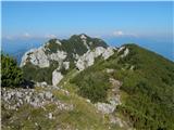 31
31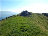 32
32 33
33
Discussion about the trip Zadnji travnik - Govca (Olševa) (hunting path)
To post a comment you must log in:
If you do not yet have a username, you must first
register.