Planina Ravne - Dleskovec (by southern mountainside)
Starting point: Planina Ravne (1500 m)
| Latitude/Longitude: | 46,3493°N 14,6997°E |
| |
Route name: by southern mountainside
Walking time: 1 h 40 min
Difficulty: easy unmarked way
Elevation gain: 465 m
Elevation difference along the route: 465 m
Map: Kamniške in Savinjske Alpe 1:50.000
Recommended equipment (summer):
Recommended equipment (winter): ice axe, crampons
Views: 29.918
 | 2 people like this post |
Access to starting point:
A) First, we drive to Kamnik, and then we continue driving towards Stahovica and the mountain pass Črnivec. A few hundred meters before the mountain pass Črnivec we leave the main road which leads towards Gornji Grad and we continue driving sharply left in the direction of the mountain pass Volovljek (Kranjski Rak). From the mentioned mountain pass we continue straight (left road which leads to Velika planina, right Štajerski Rak) and start descending towards Luče. Lower down, the road flattens a little and brings us into the Podvolovljek valley. Further on, at first we drive past the turn-off of the road which leads into the Lučka Bela valley, after that also past the bar pri Gamsu. After the bar, we need to pay attention, because only a few hundred meters further the road which leads towards the mountain pasture Podvežak and Ravne and farm Planinšek branches off to the left (by the spot where we leave the main road, there is a road sign approximately 11 km). Further, we drive on at first still asphalt road which then ascends towards the Dleskovška planota plateau. Higher, the road towards Planinšek branches off to the right, and here we continue on the left upper road, which a little further brings us to the next crossroad, where we continue straight in the direction of the mountain pasture Ravne (left mountain pasture Podvežak). Further on a somewhat rougher road, which we follow to the beginning of the mountain pasture Ravne, where we park on an appropriate place by the road.
From the main road to the mountain pasture Ravne is approximately 10 km.
B) First, we drive to Luče, and then we continue driving towards Kamnik. When by the road we notice a road sign which shows 10.5 km, we need to pay attention to the right turn-off, because only a little further to the right the road towards the mountain pasture Podvežak and Ravne and farm Planinšek branches off. Further, we drive on at first still asphalt road which then ascends towards the Dleskovška planota plateau. Higher, the road towards Planinšek branches off to the right, and here we continue on the left upper road, which a little further brings us to the next crossroad, where we continue straight in the direction of the mountain pasture Ravne (left mountain pasture Podvežak). Further on a somewhat rougher road, which we follow to the beginning of the mountain pasture Ravne, where we park on an appropriate place by the road.
Route description:
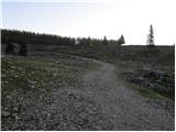
At the beginning of the mountain pasture Ravne (also Ravni) we notice wooden mountain signposts for Veliki vrh, Korošica, Molička peč or Molička planina and Dolge Trate, which point us to the left towards the nearby cottage, which is situated on the edge of the mountain pasture. We bypass the cottage on the left side, and then we pass into a narrow lane of forest, where blazes lead left. The path ahead leads us through the clearing, through which it ascends diagonally into the forest. Further, we are ascending through the forest, where we soon cross a grazing fence. Higher, the forest starts to get thinner, or changing into a lane of dwarf pines. On some spots a little worse beaten, but all the time easy to follow footpath higher flattens and brings us to the bottom edge of pastures of Dolge Trate. Here the path entirely flattens and in a few dozen strides of additional walking brings us to the shepherd hut on Dolge Trate.
At shepherd hut, where there is a smaller marked junction we continue right in the direction of Dleskovec (left mountain pasture Molička planina, Veliki vrh and Korošica). Further unmarked footpath on the left side bypasses the nearby cross and passes into dwarf pines through which it starts moderately ascending. From the cross ahead for some time we follow beaten and partly cut path, after that when it flattens and it brings us to a smaller sinkhole, it suddenly almost entirely vanishes. Here we continue on the left side of the sinkhole and we ascend among dwarf pines on the left and rocky rubble on the right. Steep part quickly ends and "path" then quickly brings us to a panoramic peak.
Planina Ravne - Dolga Trata 1:15, Dolga Trata - Dleskovec 25 minutes.

Photos:
 1
1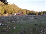 2
2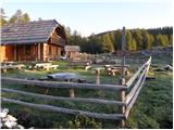 3
3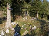 4
4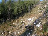 5
5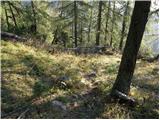 6
6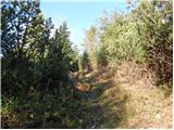 7
7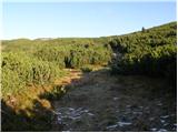 8
8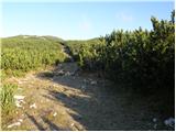 9
9 10
10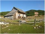 11
11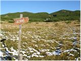 12
12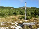 13
13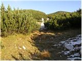 14
14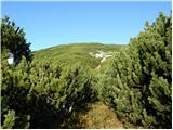 15
15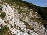 16
16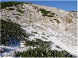 17
17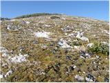 18
18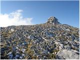 19
19
Discussion about the trip Planina Ravne - Dleskovec (by southern mountainside)
|
| fpetel115. 10. 2008 |
The trail from Ravne is wide and easy to follow. In addition to double red lines marking the parcels, old markings leading to Sedelce are visible in many places. Towards the summit of Dleskovec (I went from the summit) the trail goes through dwarf pines for a while, which doesn't hinder us too much because the trail is still quite wide and the passage doesn't last long.
|
|
|
|
| grega_p13. 09. 2009 |
In pleasant company I did a partial night hike along the described path, which is an adventure in its own right. Especially because I wasn't exactly confident about the path's condition (lots of brush and other small trails). Anyway, after an hour of panting under countless stars and interesting night sounds, we reached Dolge Trate, where we overnighted provisionally in a room (huge thanks to the owner/caretaker - chocolate left as a treat) and the next day amid fog and sun (just enough to see :-) somehow conquered Dleskovec through the brush. Really, you need to be careful and a bit brave when ascending from the hut along the gully, as the path isn't entirely easy to follow. And definitely left at the small saddle, I chose right and conquered some other "small" hillock with a figure on top.
If descending to the north side, you'll also need some ingenuity before reaching the marked path from pl. Ravne. A bit by feel, a bit groping through the brush.
Yes, looking at this landscape up there, it's not hard to say that there's something special about this high-karst area of the Kamnik Alps. We'll be back.
Grega and Anja
|
|
|
|
| Rokovnjacica11. 08. 2014 |
I was on Dleskovec via the above-described path. I also first conquered the right summit (like Grega) and from that smaller summit I quickly spotted the real one and climbed up to it too. The views are really beautiful, the paths inviting, so I'll surely come back to the Styrian parts soon.
|
|
|
|
| ločanka3. 05. 2019 |
Yesterday on this path. Really wonderful trip. It's worth doing a circular tour, descending over the summit towards Sedlec and returning via the northern slopes. At this time there is still snow on these slopes. Best to follow in the footsteps of the predecessor Of course, if you're lucky Of course, if you're lucky
|
|
|
To post a comment you must log in:
If you do not yet have a username, you must first
register.