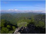
 | Dvor - Polhograjska Grmada (Dvor - Grmada - Belica)
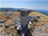
Polhograjska Grmada is an 898 m high peak located in the heart of the Polhograjski Dolomites. From the summit, which has a registration box with ...
2 h 10 min |
 | Dvor - Polhograjska Grmada (via Mala Grmada)
Polhograjska Grmada is an 898 m high peak located in the heart of the Polhograjski Dolomites. From the summit, which has a registration box with ...
1 h 45 min |
 | Gabrje - Polhograjska Grmada
Polhograjska Grmada is an 898 m high peak located in the heart of the Polhograjski Dolomites. From the summit, which has a registration box with ...
2 h 20 min |
 | Dvor - Polhograjska Grmada
Polhograjska Grmada is an 898 m high peak located in the heart of the Polhograjski Dolomites. From the summit, which has a registration box with ...
1 h 45 min |
 | Preska - Sveti Jakob
The Church of St James is located on a hill north of the village of Topol near Medvode. From the top, where there is a registration box with a st...
1 h 45 min |
| Sora - Sveti Jakob
The Church of St James is located on a hill north of the village of Topol near Medvode. From the top, where there is a registration box with a st...
1 h 45 min |
 | Preska - Sveti Jakob (via Turnice)
The Church of St James is located on a hill north of the village of Topol near Medvode. From the top, where there is a registration box with a st...
3 h |
 | Gabrje - Tošč
Tošč, which became the highest peak of Polhograjsko hribovje decades ago when Pasja ravan was lowered by 9 m by the Yugoslav army, is located nor...
3 h 5 min |
 | Škofja Loka (Vincarje) - Lubnik (ridge path)
Lubnik is a 1025 m high mountain rising steeply to the west of Škofja Loka. From the summit, on which the mountain lodge stands, you can enjoy a ...
2 h 15 min |
 | Škofja Loka - Lubnik (via Stari grad)
Lubnik is a 1025 m high mountain rising steeply to the west of Škofja Loka. From the summit, on which the mountain lodge stands, you can enjoy a ...
2 h 15 min |
| Škofja Loka - Lubnik (via Luža)
Lubnik is a 1025 m high mountain rising steeply to the west of Škofja Loka. From the summit, on which the mountain lodge stands, you can enjoy a ...
2 h |
 | Pirman - Kurešček
Kurešček is an 826 m high peak located south of Ig and south-west of Želimlje. The view from the top, on which the church stands, is not possible...
1 h 45 min |
| Želimlje - Kurešček
Kurešček is an 826 m high peak located south of Ig and south-west of Želimlje. The view from the top, on which the church stands, is not possible...
1 h 50 min |
 | Sora - Osolnik (via Hom)
Osolnik is an 858 m high mountain located south of Škofja Loka and west of Medvode. From the top, where the Church of St. Mohor and Fortunatus st...
1 h 50 min |
 | Puštal - Osolnik
Osolnik is an 858 m high mountain located south of Škofja Loka and west of Medvode. From the top, where the Church of St. Mohor and Fortunatus st...
2 h 15 min |
| Puštal (Na Dobravi) - Osolnik
Osolnik is an 858 m high mountain located south of Škofja Loka and west of Medvode. From the top, where the Church of St. Mohor and Fortunatus st...
2 h |
 | Preska - Jeterbenk (on ridge)
Jeterbenk is a 774 m high peak located between Slavko's home at Gole Brdo and Katarina (Topol village). From the top, where there is a large cros...
2 h 15 min |
 | Puštal (Na Dobravi) - Sveti Ožbolt (above Zminec)
Sveti Ožbolt is located on a scenic peak in the north of the Polhograjske Dolomites. It has a beautiful view of the Škofjeloško hribovje and part...
2 h 15 min |
 | Škofja Loka - Archangel Gabriel (Planica)
Planica is an 824 m high peak located north of Škofja Loka, between Krizna Gora and Planica. From the top, where the Church of St. Gabriel the Ar...
2 h 5 min |
 | Besnica - Janče
Janče is a 792-metre-high peak located between the Sava River and the valley of the Besnica Stream. From the top, where the mountain lodge stands...
2 h 15 min |
 | Jevnica - Janče
Janče is a 792-metre-high peak located between the Sava River and the valley of the Besnica Stream. From the top, where the mountain lodge stands...
1 h 45 min |
 | Laze pri Dolskem - Janče
Janče is a 792-metre-high peak located between the Sava River and the valley of the Besnica Stream. From the top, where the mountain lodge stands...
2 h 15 min |
 | Kamnica - Sveti Miklavž above Sava (via Velika vas)
The Church of St Nicholas is situated on a hill south of Moravče. From the top you can enjoy a beautiful view of the nearby Limbarska gora, and t...
2 h 5 min |
 | Kamnica - Cicelj (via farm Buven)
Cicelj is a forested peak located between Moravče and the village of Senožeti. There is no view from the top, which has a bench and a registratio...
1 h 45 min |
 | Stomaž - Mala gora
Mala gora is a plateau on the slope of the Chavn. A hut is located at an altitude of 1034 metres. Mala gora is known for its flowers, which are u...
2 h |
 | Kamnje - Mala gora
Mala gora is a plateau on the slope of the Chavn. A hut is located at an altitude of 1034 metres. Mala gora is known for its flowers, which are u...
2 h |
 | Vrtovin - Mala gora
Mala gora is a plateau on the slope of the Chavn. A hut is located at an altitude of 1034 metres. Mala gora is known for its flowers, which are u...
2 h 15 min |
 | Breg (Liški potok) - Lisca
Lisca is a scenic peak located north of Sevnica. From the top of the peak, where the meteorological radar station stands, there is a beautiful vi...
2 h 5 min |
| Krakovo (Mastnak wine cellar) - Lisca (via Skalce)
Lisca is a scenic peak located north of Sevnica. From the top of the peak, where the meteorological radar station stands, there is a beautiful vi...
1 h 50 min |
| Krakovo (Mastnak wine cellar) - Lisca (Pastirčkova pot)
Lisca is a scenic peak located north of Sevnica. From the top of the peak, where the meteorological radar station stands, there is a beautiful vi...
1 h 55 min |
| Krakovo (Mastnak wine cellar) - Lisca (past Sveti Jošt)
Lisca is a scenic peak located north of Sevnica. From the top of the peak, where the meteorological radar station stands, there is a beautiful vi...
1 h 55 min |
 | Rimske Toplice - Dom v Gorah (via Ogeški potok)
The mountain lodge in Gora is located east of Hrastnik, just a few metres below the 786m-high peak on which the Church of St George stands. From ...
2 h 40 min |
| Rimske Toplice (Šmarjeta) - Dom v Gorah (via Lurd)
The mountain lodge in Gora is located east of Hrastnik, just a few metres below the 786m-high peak on which the Church of St George stands. From ...
2 h 40 min |
 | Source of Hubelj - Sinji vrh (via Otliško okno)
Sinji vrh is a scenic mountain located between Col, Ajdovščina and Predmeja. From the top, you can enjoy a beautiful view over most of western Sl...
2 h 15 min |
 | Jamce - Sinji vrh (eastern path via Škraplje)
Sinji vrh is a scenic mountain located between Col, Ajdovščina and Predmeja. From the top, you can enjoy a beautiful view over most of western Sl...
2 h 55 min |
 | Cerkno - Bevkov vrh
Bevkov vrh, which is a point on the Slovenian mountain trail, is located between Cerkno and Spodnja Idrija. The summit is covered with forest and...
2 h 50 min |
| Straža - Želin - Bevkov vrh
Bevkov vrh, which is a point on the Slovenian mountain trail, is located between Cerkno and Spodnja Idrija. The summit is covered with forest and...
2 h 45 min |
 | Idrija - Hleviška planina (hunting path)
Hleviška planina (also Hleviška planina) is a slightly overgrown but still very scenic peak. From the top, which is the house mountain of Idrija,...
1 h 45 min |
 | Divje jezero - Hleviška planina (via Prižnica)
Hleviška planina (also Hleviška planina) is a slightly overgrown but still very scenic peak. From the top, which is the house mountain of Idrija,...
2 h 30 min |
 | Idrija - Hleviška planina (via Kodrov rovt)
Hleviška planina (also Hleviška planina) is a slightly overgrown but still very scenic peak. From the top, which is the house mountain of Idrija,...
2 h |
 | Stoperce - Donačka gora
Donačka gora is a peak located north of Rogatec. The peak, which geographically belongs to Karawanks, offers a beautiful view of the surrounding ...
2 h 5 min |
 | Zidani Most - Veliko Kozje
Veliko Kozje is a peak located west of Zidanega Most. From the summit, which has a registration box, there is a beautiful view of Zasavska and Po...
2 h 30 min |
 | Gračnica - Veliko Kozje
Veliko Kozje is a peak located west of Zidanega Most. From the summit, which has a registration box, there is a beautiful view of Zasavska and Po...
2 h |
 | Polzela - Gora Oljka (via Vimperk)
Gora Oljka is a hill located east of Šmartno ob Paki. On the top stands the Church of the Holy Cross, which was built in the mid-18th century. Ju...
2 h 15 min |
 | Prebold - Reška planina (via Tolsti vrh and Strnik)
Reška planina is a peak in Posavsko hribovje, located southwest of Prebold. The marked trail does not lead to the summit, but to a nearby viewpoi...
3 h |
 | Prebold - Golava
Golava is a peak located north of Mrzlica. From the summit, on which a small bivouac (Blaž's bivouac) stands, there is a beautiful view towards t...
1 h 45 min |
 | Zabukovica - Gozdnik
Gozdnik is a hill rising steeply above the village of Zabukovica. There is no view from the top, due to the forest, but there is a bivouac on it,...
2 h 5 min |
 | Pongrac (Hostage cemetery) - Gozdnik (past Petelinov vrh)
Gozdnik is a hill rising steeply above the village of Zabukovica. There is no view from the top, due to the forest, but there is a bivouac on it,...
2 h |
| Pongrac (Hostage cemetery) - Gozdnik (past Mali Gozdnik)
Gozdnik is a hill rising steeply above the village of Zabukovica. There is no view from the top, due to the forest, but there is a bivouac on it,...
2 h 5 min |
 | Laško - Dom na Šmohorju
Dom na Šmohorju is located between Laško, Liboje and Zabukovica. From the house, or from the Church of St. Mohorj, a few minutes away, there is a...
2 h |
 | Spodnja Rečica - Malič (via Tolsto)
Malič is a 936 m high peak located between Celje and Laško, above Spodnja Rečica. There is no better view from the top, where the transmitter, be...
2 h 15 min |
| Laško - Malič
Malič is a 936 m high peak located between Celje and Laško, above Spodnja Rečica. There is no better view from the top, where the transmitter, be...
2 h 15 min |
 | Tremerje - Malič (on western ridge of Malič)
Malič is a 936 m high peak located between Celje and Laško, above Spodnja Rečica. There is no better view from the top, where the transmitter, be...
2 h |
| Zgornja Rečica (church of Blessed Anton Martin Slomšek) - Malič
Malič is a 936 m high peak located between Celje and Laško, above Spodnja Rečica. There is no better view from the top, where the transmitter, be...
2 h 20 min |
 | Gradišče - Gradiška Tura (via Plaz)
Gradiška Tura is a peak located on the western side of the Nanoška plateau. From the top, which is reached by a well-maintained climbing route an...
2 h |
 | Zamedveje - Korada
Korada is a scenic peak located to the west of the Soča River and to the north or on the northern edge of Goriško Brda. From the summit, which ha...
2 h 30 min |
 | Zagrad - Tolsti vrh above Celjska koča (eastern way)
Tolsti, according to some records also Tovsto vrh, is located above the Celjska koča ski resort. The summit, which has a registration box and a s...
1 h 45 min |
 | Štore - Tolsti vrh above Celjska koča (via Žlajfa)
Tolsti, according to some records also Tovsto vrh, is located above the Celjska koča ski resort. The summit, which has a registration box and a s...
2 h 15 min |
 | Štore - Tolsti vrh above Celjska koča (via Bojanski graben)
Tolsti, according to some records also Tovsto vrh, is located above the Celjska koča ski resort. The summit, which has a registration box and a s...
2 h 30 min |
 | Štore - Tolsti vrh above Celjska koča (via Marija)
Tolsti, according to some records also Tovsto vrh, is located above the Celjska koča ski resort. The summit, which has a registration box and a s...
2 h |
 | Zvodno - Tolsti vrh above Celjska koča (via Srebotnik on CPP)
Tolsti, according to some records also Tovsto vrh, is located above the Celjska koča ski resort. The summit, which has a registration box and a s...
2 h 15 min |
| Hayrack (Laška vas - Pečovje) - Tolsti vrh above Celjska koča (via Srebotnik on CPP)
Tolsti, according to some records also Tovsto vrh, is located above the Celjska koča ski resort. The summit, which has a registration box and a s...
2 h 15 min |
| Teharje - Tolsti vrh above Celjska koča (via Srebotnik on CPP)
Tolsti, according to some records also Tovsto vrh, is located above the Celjska koča ski resort. The summit, which has a registration box and a s...
3 h |
 | Slovenske Konjice - Stolpnik (via castle)
At 1012 m, Stolpnik is the highest peak of the Konjiška Gora, a mountain range stretching south-west from Slovenske Konjice. A 25 m high lookout ...
2 h 15 min |
 | Slovenske Konjice - Stolpnik (Zmajčkova pot)
At 1012 m, Stolpnik is the highest peak of the Konjiška Gora, a mountain range stretching south-west from Slovenske Konjice. A 25 m high lookout ...
1 h 45 min |
 | Podgorje ob Sevnični (Kurja vas) - Skalica (Bohor)
Skalica is a less known peak in the western part of Bohor. From the summit, which has a registration box, there is a beautiful view to the south ...
2 h 20 min |
 | Kozje - Veliki Javornik (Bohor) (via Koprivnik)
Veliki Javornik is the highest peak of Bohor at 1023m. Although the peak is unspoilt and there are no higher hills far around, there is no view f...
2 h 45 min |
 | Podgorje ob Sevnični (Kurja vas) - Veliki Javornik (Bohor)
Veliki Javornik is the highest peak of Bohor at 1023m. Although the peak is unspoilt and there are no higher hills far around, there is no view f...
2 h 40 min |
 | Podgozd - Sveti Peter
Sveti Peter is a partially vegetated peak in the Dry Krajina above the village of Dvor. On the top there is a small shelter (usually open on Sund...
1 h 50 min |
 | Preska - Rog (via Turnice)
The Rog is a 798 m high peak located above the village of Topole, just 10 minutes from St Catherine's Church. From the top of the hill, where a l...
2 h 30 min |
| Preska - Rog (via Jeterbenk)
The Rog is a 798 m high peak located above the village of Topole, just 10 minutes from St Catherine's Church. From the top of the hill, where a l...
2 h 45 min |
 | Radeče - Nebeška gora
Nebeška gora is the highest peak of the municipality of Radeče on the Sava River. There is a registration book and a stamp on the top, as well as...
2 h 45 min |
| Zidani Most - Nebeška gora (eastern path)
Nebeška gora is the highest peak of the municipality of Radeče on the Sava River. There is a registration book and a stamp on the top, as well as...
2 h 40 min |
| Zidani Most - Nebeška gora (western path)
Nebeška gora is the highest peak of the municipality of Radeče on the Sava River. There is a registration book and a stamp on the top, as well as...
2 h 45 min |
 | Cerkno - Ermanovec (via Kladje)
Ermanovec is a 1026 m high peak located between Cerkno and Gorenjska vasja, specifically above Sovodnje and Trebija. Just a few steps away from t...
2 h 55 min |
| Cerkno - Ermanovec (via Planina pri Cerknem)
Ermanovec is a 1026 m high peak located between Cerkno and Gorenjska vasja, specifically above Sovodnje and Trebija. Just a few steps away from t...
3 h |
 | Hrastnik - Klobuk (via Ravne)
Klobuk is a scenic peak located northeast of Hrastnik. The summit, which has a registration box and a stamp, offers a beautiful view of the valle...
2 h 25 min |
| Dol pri Hrastniku - Klobuk
Klobuk is a scenic peak located northeast of Hrastnik. The summit, which has a registration box and a stamp, offers a beautiful view of the valle...
2 h 10 min |
 | Hrastnik - Kal (Kalski hrib) (via Klobuk)
Kal is a 985m high peak located between the more famous Mrzlica and the lesser known Klobuk. From the top where the bench stands, there is no bet...
2 h 25 min |
| Hrastnik - Kal (Kalski hrib) (via Ravne)
Kal is a 985m high peak located between the more famous Mrzlica and the lesser known Klobuk. From the top where the bench stands, there is no bet...
2 h 25 min |
 | Dol pri Hrastniku - Kal (Kalski hrib)
Kal is a 985m high peak located between the more famous Mrzlica and the lesser known Klobuk. From the top where the bench stands, there is no bet...
2 h 10 min |
| Hrastnik - Kal (Kalski hrib) (via Blate)
Kal is a 985m high peak located between the more famous Mrzlica and the lesser known Klobuk. From the top where the bench stands, there is no bet...
2 h 20 min |
 | Gorjuša - Murovica (via Dobovlje)
Murovica is a popular excursion point, accessible from the Posavina side, Domžale or from the Moravška valley. There is a bench and a registratio...
2 h 40 min |
 | Senožeti - Murovica (via Vrh pri Dolskem)
Murovica is a popular excursion point, accessible from the Posavina side, Domžale or from the Moravška valley. There is a bench and a registratio...
2 h 5 min |
| Senožeti - Murovica (via farm Buven)
Murovica is a popular excursion point, accessible from the Posavina side, Domžale or from the Moravška valley. There is a bench and a registratio...
1 h 55 min |
 | Laško (cemetery Laško) - Govško brdo
Govško brdo is an 811m high hill located west of the village of Huda jama above Laško. From the top of the hill, where the registration box and s...
2 h 35 min |
 | Bistra - Mali Trebelnik
Mali Trebelnik is an 807 m high peak rising above the south-western part of the Ljubljana Marshes. Partly grassy and partly surrounded by forest,...
1 h 45 min |
 | Socka - Špicasti vrh (Kislica)
Špičasti vrh aka Kislica (the name of a small ridge south of Mala gora and the town of Vitanje) is a 994 m hill situated between Vojnik and Stran...
2 h 15 min |
 | Trbovlje - Sveta planina (Partizanski vrh)
Sveta planina, also Partizanski vrh, is a 1011 m high mountain located between Čemšeniška mountain pasture and Mrzlica. From the top, where a sma...
2 h |
 | Cerkno - Štor (via Kladje)
Štor is a 1005 m high peak located directly above the Ermanovec Cottage. The peak itself is covered with forest, but from the meadow, which is on...
2 h 40 min |
| Cerkno - Štor (via Planina pri Cerknem)
Štor is a 1005 m high peak located directly above the Ermanovec Cottage. The peak itself is covered with forest, but from the meadow, which is on...
2 h 45 min |
 | Cerkno - Veliki vrh (Lajše)
Veliki vrh is an almost 900 m high peak rising south of Cerkno. From the top, where there are several television and radio transmitters covering ...
2 h |
 | Cerkno - Škofje
Škofje is a 973 m high peak located above the villages of Čeplez, Planina pri Cerknem and Podpleče. The peak itself, on which stands a small conc...
1 h 45 min |
 | Izlake - Pleše (via Grobovščica)
Pleše is an 866 m high peak located between the Marela Ski Resort and Zasavska Sveta Gora. From the top, where the NOB monument is located, you h...
2 h 15 min |
 | Izlake - Pleše (via Vežnica)
Pleše is an 866 m high peak located between the Marela Ski Resort and Zasavska Sveta Gora. From the top, where the NOB monument is located, you h...
1 h 45 min |
 | Braslovško jezero - Grmada (Dobrovlje)
Grmada is an 898 m high forested peak located in the south-eastern part of the Dobrovlje plateau. The summit, on which the stamp is located, is n...
2 h 25 min |
| Letuš - Grmada (Dobrovlje)
Grmada is an 898 m high forested peak located in the south-eastern part of the Dobrovlje plateau. The summit, on which the stamp is located, is n...
2 h 25 min |
| Žovneško jezero - Grmada (Dobrovlje)
Grmada is an 898 m high forested peak located in the south-eastern part of the Dobrovlje plateau. The summit, on which the stamp is located, is n...
2 h 5 min |
 | Zagreb (Šestine) - Sljeme (path HPD (path 52))
...
2 h 15 min |
 | Matrafuered - Kékestető (pot modri križ)
Matra is a mountain range located 70 km east of Budapest. The two highest peaks in Hungary are Kékestető, which is the highest peak in Hungary at...
2 h |
 | Matrafuered - Kékestető (Marijina pot)
Matra is a mountain range located 70 km east of Budapest. The two highest peaks in Hungary are Kékestető, which is the highest peak in Hungary at...
2 h |
 | Matrafüred - Kékestető (red path via Peresberc in Negyeshatar)
Matra is a mountain range located 70 km east of Budapest. The two highest peaks in Hungary are Kékestető, which is the highest peak in Hungary at...
2 h 45 min |
 | Matrafüred - Kékestető (pot modri trikotnik)
Matra is a mountain range located 70 km east of Budapest. The two highest peaks in Hungary are Kékestető, which is the highest peak in Hungary at...
2 h |
 | Matrafüred - Kékestető (zelena pot)
Matra is a mountain range located 70 km east of Budapest. The two highest peaks in Hungary are Kékestető, which is the highest peak in Hungary at...
2 h 15 min |
 | Lesično - Oslica (Bohor)
Oslica is one of the peaks of Bohor. It is located in the eastern part of the mountain range. Unlike some of the higher peaks of Bohor, such as V...
1 h 45 min |
 | Kozje - Oslica (Bohor) (via Vetrnik)
Oslica is one of the peaks of Bohor. It is located in the eastern part of the mountain range. Unlike some of the higher peaks of Bohor, such as V...
2 h 10 min |
 | Lesično - Debeli vrh (Bohor)
Debeli vrh is a 921-metre-high peak on Bohor between Veliki Koprivnik and Oslice. It is overgrown with dense forest, so there are no views. There...
1 h 45 min |
 | Kozje - Debeli vrh (Bohor) (via Vetrnik)
Debeli vrh is a 921-metre-high peak on Bohor between Veliki Koprivnik and Oslice. It is overgrown with dense forest, so there are no views. There...
2 h 35 min |
 | Kozje - Brest (Bohor) (via Vetrnik)
Brest is a peak on Bohor although it loks more like a saddle. It is an important intersection of the Bohor trails. It lies between Oslica, which ...
2 h |
 | Štore - Veliki vrh above Svetina (via Marija and over Svetina)
Veliki vrh is located south-west of Svetina above Štorá. It is inhabited mainly from the south and one of the homesteads is directly below the pe...
2 h 30 min |
 | Štore - Veliki vrh above Svetina (via Žlajfa and via Svetina)
Veliki vrh is located south-west of Svetina above Štorá. It is inhabited mainly from the south and one of the homesteads is directly below the pe...
2 h 15 min |
 | Štore - Veliki vrh above Svetina (through Bojanski graben and over Svetina)
Veliki vrh is located south-west of Svetina above Štorá. It is inhabited mainly from the south and one of the homesteads is directly below the pe...
2 h 30 min |
 | Studenice - Plešivec (at Boč)
Peace, silence, rugged terrain... the characteristics of a peak at the "crossroads" of many routes between the Maribor, Celje and Ptuj areas. Ple...
2 h |
 | Studenice - Plešivec (at Boč) (final part on forest road)
Peace, silence, rugged terrain... the characteristics of a peak at the "crossroads" of many routes between the Maribor, Celje and Ptuj areas. Ple...
2 h |
 | Podvelka - Hlebov vrh (Rdeči Breg) (via Viltužnik)
The Red Bank stretches between the Radoljna Gorge in the east, the Drava River in the north and the Velka Stream in the east. It is separated fro...
2 h |
 | Puščava - Hlebov vrh (Rdeči Breg)
The Red Bank stretches between the Radoljna Gorge in the east, the Drava River in the north and the Velka Stream in the east. It is separated fro...
2 h 55 min |
| HE Ožbalt - Hlebov vrh (Rdeči Breg)
The Red Bank stretches between the Radoljna Gorge in the east, the Drava River in the north and the Velka Stream in the east. It is separated fro...
2 h 50 min |
 | Zidani Most - Sveta Marija (Ključevica)
The Church of St Mary is located on a hill called Ključevica, which rises 1067 metres above sea level. From the top, which is partly covered with...
2 h 30 min |
| Dolina Sopote (Zagrad) - Sveta Marija (Ključevica)
The Church of St Mary is located on a hill called Ključevica, which rises 1067 metres above sea level. From the top, which is partly covered with...
2 h 35 min |
 | Nakovana - Sveti Ilija (Pelješac)
Sv. Ilija, also known as Zmija's Bumblebee, is a 961-metre-high mountain and the highest peak on the Pelješac peninsula. From the top, you can en...
2 h 45 min |
 | Dravograd lake - Šteharski vrh (Šteharnikov vrh)
Šteharski or Šteharnikov vrh, also Črneška gora, is a 1018-metre-high mountain located in the south-eastern part of Strojna, a mountain range bet...
2 h 15 min |
 | Muta (Spodnja Muta) - Bricnik
Bricnik is a 1017-metre-high peak located in the Kozjak Mountains, above Muta. On the top, which is covered by forest, there is a registration bo...
1 h 50 min |
 | Brezno - Sveti Pankracij (Radelca) (by Remšniški potok)
The Church of St Pancras on Radelca is located on the border ridge between Slovenia and Austria, but since 1966, following an inter-state agreeme...
2 h 50 min |
 | Muta (Spodnja Muta) - Sveti Trije Kralji (above Radlje ob Dravi)
The Church of the Three Kings is situated on an 820-metre-high hill rising above the right bank of the Radlje Stream. The church offers a beautif...
2 h 30 min |
 | Dravograd (Meža) - Golarjev vrh
Golarjev vrh is an 843 m high forested peak located south to south-east of the Cvitrško saddle, between Otiški Vrh and Sveti Danijel....
1 h 50 min |
 | Dravograd (Meža) - Anski vrh (above Pameče)
Anski vrh is a lookout point above Pameče, on which the Church of St Anne stands. From the church or the surrounding area, we have a beautiful vi...
3 h |
 | Zia - Dikeos (Kos)
Dikeos (846 m) is the highest mountain on the Kos island, the third-largest Dodecanese island in the southeastern Aegean sea in Greece (after Rho...
1 h 50 min |
 | Velem - Irrotkő / Geschriebenstein (path blue plus)
Irrotkő is the highest peak of the Kőszegi Hegység (Kőszegi Mountains) and also the highest peak in western Hungary and the Austrian state of Bur...
1 h 45 min |
 | Rechnitz (Badesee) - Irrotkő / Geschriebenstein
Irrotkő is the highest peak of the Kőszegi Hegység (Kőszegi Mountains) and also the highest peak in western Hungary and the Austrian state of Bur...
2 h 30 min |
 | Lockenhaus - Irrotkő / Geschriebenstein (via Weidriegel)
Irrotkő is the highest peak of the Kőszegi Hegység (Kőszegi Mountains) and also the highest peak in western Hungary and the Austrian state of Bur...
2 h 45 min |
| Lockenhaus - Irrotkő / Geschriebenstein (through Marchgraben)
Irrotkő is the highest peak of the Kőszegi Hegység (Kőszegi Mountains) and also the highest peak in western Hungary and the Austrian state of Bur...
2 h 40 min |
 | Ožbalt - Sršenov vrh
Sršenov vrh is a 963-metre-high peak located in the Kozjak Mountains, specifically between Ožbalt and Zgornja Kapla. The peak itself does not off...
2 h 45 min |
 | Puščava - Klančnik (Glančnik)
Klančnik, also known as Glančnik on some maps, is an 877-metre-high peak located above the right bank of the Drava River, just a few minutes away...
2 h 15 min |
| HE Ožbalt - Klančnik (Glančnik)
Klančnik, also known as Glančnik on some maps, is an 877-metre-high peak located above the right bank of the Drava River, just a few minutes away...
2 h 10 min |
 | Podvelka - Klančnik (Glančnik) (via Sveti Ignacij)
Klančnik, also known as Glančnik on some maps, is an 877-metre-high peak located above the right bank of the Drava River, just a few minutes away...
2 h 30 min |
 | Rimske Toplice - Vrhe (at Gore) (via Ogeški potok)
...
2 h 50 min |
| Rimske Toplice (Šmarjeta) - Vrhe (at Gore) (via Lurd)
...
2 h 50 min |
 | Rechnitz (Badesee) - Großer Hirschenstein
...
2 h |
 | Vuzenica - Sedovnikov vrh
...
2 h 35 min |
 | Selnica ob Dravi - Kranjčeva pečina
...
2 h 10 min |
 | Podgorje ob Sevnični (Kurja vas) - Ješivec
...
2 h 45 min |
 | Prebold - Strtnik (Strnik) (via Tolsti vrh)
...
1 h 55 min |
 | Podgorje ob Sevnični (Kurja vas) - Zaloška gora
...
1 h 55 min |
 | Prebold - Homič (on logging trail)
...
2 h 55 min |
| Prebold - Homič (via Kriška planina)
...
3 h 5 min |
| Marija Reka (Koritnikov most) - Homič (on logging trail)
...
2 h 30 min |
| Marija Reka (Koritnikov most) - Homič (via Kriška planina)
...
2 h 40 min |
| Trbovlje - Homič
...
2 h 15 min |
 | Majkovi - Neprobić
...
3 h |
 | Žabče (road to Tolminske Ravne) - Poloje
...
2 h |