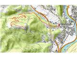
 | Deutschfeistritz - Schartnerkogel (on road)
Schartnerkogel is a 931m high hill above the town of Deutschfeistritz (German Bistritz) in the western part of the Graz mountain range. A cross s...
2 h |
 | Ernejčkov graben - Sivka
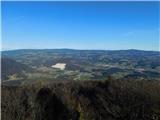
Sivka is a grassy peak located in the westernmost part of the Polhograje Hills. In good weather, the peak offers a magnificent view from Snežnik ...
2 h |
 | Zgornja Besnica (Podrovnik) - Sveti Mohor (Zabrekve)
The Church of St. Mohor is situated on a 952 m high hill, between Zgornja Besnica and Selce. From the church, or its immediate surroundings, we h...
1 h 45 min |
 | Selca - Miklavška gora (footpath)
Miklavška gora is a lookout located south of Železniki and Selce. From the top of the hill on which the Church of St Nicholas stands, we have a b...
1 h 25 min |
 | Blagovica - Špilk
Špilk is a 956 m high peak located north of Blagovica. On the summit, which is mostly forested, PD Blagovica has built a small bivouac with a ben...
1 h 30 min |
 | Trojane - Špilk
Špilk is a 956 m high peak located north of Blagovica. On the summit, which is mostly forested, PD Blagovica has built a small bivouac with a ben...
2 h 30 min |
 | Hotavlje - Vrhovski grič (via Slajka)
Vrhovski grič is a scenic hill located along the marked Trebija - Ermanovec trail. The grassy summit offers a beautiful view of the surrounding h...
2 h 30 min |
 | Trebija - Vrhovski grič
Vrhovski grič is a scenic hill located along the marked Trebija - Ermanovec trail. The grassy summit offers a beautiful view of the surrounding h...
1 h 35 min |
| Trebija - Vrhovski grič (via Sveti Pavel)
Vrhovski grič is a scenic hill located along the marked Trebija - Ermanovec trail. The grassy summit offers a beautiful view of the surrounding h...
1 h 45 min |
 | Hunting cottage Budanje - Kovk
Kovk is a scenic peak located to the west of Cola, on a jagged ridge rising steeply above the Vipava valley. From the top with a cross, we have a...
1 h 30 min |
 | Ribnica (Lepovče) - Stene svete Ane
Stene svete Ane is a vegetated peak located near the mountain hut at Sveti Anna on Mali gora. A small observation tower stands on the summit, whi...
1 h 35 min |
 | Tržič - Veliki vrh above Završnik (via Kamnek)
Veliki vrh above Završnik is a 968 m high mountain located in the Pirmance ridge, north to north-east of Tržič. From the grassy summit, where the...
1 h 45 min |
 | Kočevje - Fridrihštajn Castle (Grajska way)
Fridrihštajn Castle, built in the 15th century, is located to the south of Kočevje on a 970m high hill. Today, only the ruins of the castle remai...
1 h 30 min |
 | Vinska Gora - Ramšakov vrh (easy path)
Ramšakov vrh is the highest point of the circular route around Vinská Gora. On the 970 m high summit, besides the bench, there is a registration ...
2 h |
 | Vinska Gora - Ramšakov vrh (via farm Vodošek)
Ramšakov vrh is the highest point of the circular route around Vinská Gora. On the 970 m high summit, besides the bench, there is a registration ...
2 h |
 | Ledinica - Planinska koča Mrzl'k
Planinska koča Mrzl'k is located just a few metres below the summit of Mrzlik. The hut offers a beautiful view of the neighbouring Mrzli vrh (Lon...
1 h 45 min |
| Žiri - Planinska koča Mrzl'k
Planinska koča Mrzl'k is located just a few metres below the summit of Mrzlik. The hut offers a beautiful view of the neighbouring Mrzli vrh (Lon...
2 h |
 | Ledinica - Planinska koča Mrzl'k (via Jarčja Dolina)
Planinska koča Mrzl'k is located just a few metres below the summit of Mrzlik. The hut offers a beautiful view of the neighbouring Mrzli vrh (Lon...
1 h 45 min |
 | Cerkno - Škofje
Škofje is a 973 m high peak located above the villages of Čeplez, Planina pri Cerknem and Podpleče. The peak itself, on which stands a small conc...
1 h 45 min |
| Dolenji Novaki (Pod Kovkom) - Škofje
Škofje is a 973 m high peak located above the villages of Čeplez, Planina pri Cerknem and Podpleče. The peak itself, on which stands a small conc...
2 h |
 | Stubenbergsee - Kulm (via Kulmkögerl)
Kulm is a 975-metre-high lookout peak located a short walk from Weiz. From the top, where there are several religious buildings, you can enjoy a ...
2 h |
 | Planina pri Sevnici - Koprivnik (Bohor)
Koprivnik or Veliki Koprivnik is one of the many peaks in Bohor. It is located between Koča na Bohorju and Veliki Koprivnik. From the top of the ...
2 h |
 | Ledinica - Loncmanova Sivka (Mrzli Vrh)
Loncmanova Sivka is a scenic peak located above the village of Mrzli Vrh above Žirmi. From the uncultivated peak, in good weather, we can enjoy v...
1 h 35 min |
 | Žiri - Loncmanova Sivka (Mrzli Vrh)
Loncmanova Sivka is a scenic peak located above the village of Mrzli Vrh above Žirmi. From the uncultivated peak, in good weather, we can enjoy v...
1 h 40 min |
 | Paka pri Velenju - Visoko
Visoko is an easily accessible grassy plateau located south of Paško Kozjak. On the top stands a monument to the fallen fighters of the 14th NOV ...
1 h 45 min |
 | Kočevje - Livoldski vrh (Grajska way)
Livoldski vrh is a forested peak located in the south-eastern part of Stojna. The summit has a registration box and a stamp....
1 h 45 min |
 | Socka - Špicasti vrh (Kislica)
Špičasti vrh aka Kislica (the name of a small ridge south of Mala gora and the town of Vitanje) is a 994 m hill situated between Vojnik and Stran...
2 h 15 min |
 | Trpčane - Koča na Kozleku
The hut is located south-west of Ilirska Bistrica, just a few metres below the top of Kozlek. From the top, the view is only to the south and wes...
1 h 45 min |
| Jablanica - Koča na Kozleku
The hut is located south-west of Ilirska Bistrica, just a few metres below the top of Kozlek. From the top, the view is only to the south and wes...
1 h 45 min |
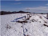
 | Frohnleiten - Gschwendt (Gschwendtberg)
Gschwendt or Gschwendtberg is a 1000m high hill above the town of Frohnleiten in the eastern part of the Graz mountain range. Gschwendt has 2 pea...
1 h 45 min |
 | Kopačnica - Štor
Štor is a 1005 m high peak located directly above the Ermanovec Cottage. The peak itself is covered with forest, but from the meadow, which is on...
1 h 25 min |
| Hotavlje - Štor (by road)
Štor is a 1005 m high peak located directly above the Ermanovec Cottage. The peak itself is covered with forest, but from the meadow, which is on...
2 h 15 min |
| Trebija - Štor (via Ermanovec)
Štor is a 1005 m high peak located directly above the Ermanovec Cottage. The peak itself is covered with forest, but from the meadow, which is on...
2 h 20 min |
 | Ledinica - Sivka
Sivka is a forested peak located west of Žiri and north of Idrija. On the summit there is a stamp of the Slovenian mountain trail and a registrat...
1 h 50 min |
| Žiri - Sivka
Sivka is a forested peak located west of Žiri and north of Idrija. On the summit there is a stamp of the Slovenian mountain trail and a registrat...
2 h |
 | Žiri - Sivka (via Vrsnik)
Sivka is a forested peak located west of Žiri and north of Idrija. On the summit there is a stamp of the Slovenian mountain trail and a registrat...
2 h 30 min |
 | Kočevje - Požgani hrib (Kalan way)
Požgani hrib is a 1009m high peak located in the heart of the vast forests of Stojna. As the peak is mostly covered by forest, it offers some vie...
2 h |
| Kočevje - Požgani hrib (Grajska way)
Požgani hrib is a 1009m high peak located in the heart of the vast forests of Stojna. As the peak is mostly covered by forest, it offers some vie...
1 h 50 min |
 | Loke - Sveta planina (Partizanski vrh)
Sveta planina, also Partizanski vrh, is a 1011 m high mountain located between Čemšeniška mountain pasture and Mrzlica. From the top, where a sma...
2 h 25 min |
 | Slovenske Konjice - Stolpnik (via castle)
At 1012 m, Stolpnik is the highest peak of the Konjiška Gora, a mountain range stretching south-west from Slovenske Konjice. A 25 m high lookout ...
2 h 15 min |
 | Slovenske Konjice - Stolpnik (Zmajčkova pot)
At 1012 m, Stolpnik is the highest peak of the Konjiška Gora, a mountain range stretching south-west from Slovenske Konjice. A 25 m high lookout ...
1 h 45 min |
 | Črešnjice - Stolpnik
At 1012 m, Stolpnik is the highest peak of the Konjiška Gora, a mountain range stretching south-west from Slovenske Konjice. A 25 m high lookout ...
1 h 25 min |
 | Žička kartuzija - Stolpnik (via Krniški rob)
At 1012 m, Stolpnik is the highest peak of the Konjiška Gora, a mountain range stretching south-west from Slovenske Konjice. A 25 m high lookout ...
2 h 30 min |
 | Črešnjice - Stolpnik (Črešnjice - Stolpnik - Sojek)
At 1012 m, Stolpnik is the highest peak of the Konjiška Gora, a mountain range stretching south-west from Slovenske Konjice. A 25 m high lookout ...
2 h 30 min |
 | Stranice - Stolpnik (via Grofov štant)
At 1012 m, Stolpnik is the highest peak of the Konjiška Gora, a mountain range stretching south-west from Slovenske Konjice. A 25 m high lookout ...
2 h 25 min |
 | Stranice - Stolpnik (via hunting cottage Štepih)
At 1012 m, Stolpnik is the highest peak of the Konjiška Gora, a mountain range stretching south-west from Slovenske Konjice. A 25 m high lookout ...
2 h 15 min |
| Spodnje Stranice (graves of hundred hostages) - Stolpnik (via hunting cottage Štepih)
At 1012 m, Stolpnik is the highest peak of the Konjiška Gora, a mountain range stretching south-west from Slovenske Konjice. A 25 m high lookout ...
2 h |
| Spodnje Stranice (graves of hundred hostages) - Stolpnik (via Grofov štant)
At 1012 m, Stolpnik is the highest peak of the Konjiška Gora, a mountain range stretching south-west from Slovenske Konjice. A 25 m high lookout ...
2 h 10 min |
 | Frankolovo - Stolpnik
At 1012 m, Stolpnik is the highest peak of the Konjiška Gora, a mountain range stretching south-west from Slovenske Konjice. A 25 m high lookout ...
2 h 30 min |
 | Matrafuered - Kékestető (pot modri križ)
Matra is a mountain range located 70 km east of Budapest. The two highest peaks in Hungary are Kékestető, which is the highest peak in Hungary at...
2 h |
 | Matrafuered - Kékestető (Marijina pot)
Matra is a mountain range located 70 km east of Budapest. The two highest peaks in Hungary are Kékestető, which is the highest peak in Hungary at...
2 h |
 | Matrafüred - Kékestető (pot modri trikotnik)
Matra is a mountain range located 70 km east of Budapest. The two highest peaks in Hungary are Kékestető, which is the highest peak in Hungary at...
2 h |
 | Muta (Spodnja Muta) - Bricnik
Bricnik is a 1017-metre-high peak located in the Kozjak Mountains, above Muta. On the top, which is covered by forest, there is a registration bo...
1 h 50 min |
 | Radlje ob Dravi - Bricnik
Bricnik is a 1017-metre-high peak located in the Kozjak Mountains, above Muta. On the top, which is covered by forest, there is a registration bo...
2 h 30 min |
| Dolina Radeljskega potoka (Razdevšek) - Bricnik
Bricnik is a 1017-metre-high peak located in the Kozjak Mountains, above Muta. On the top, which is covered by forest, there is a registration bo...
2 h 20 min |
 | Ravne na Koroškem - Šteharski vrh (Šteharnikov vrh)
Šteharski or Šteharnikov vrh, also Črneška gora, is a 1018-metre-high mountain located in the south-eastern part of Strojna, a mountain range bet...
1 h 45 min |
| Dravograd lake - Šteharski vrh (Šteharnikov vrh)
Šteharski or Šteharnikov vrh, also Črneška gora, is a 1018-metre-high mountain located in the south-eastern part of Strojna, a mountain range bet...
2 h 15 min |
 | Hotovlja - Pasja ravan
Pasja ravan is the second highest peak in the Polhograje Hills. A few decades ago, at 1029 m, it was the highest peak, but the Yugoslav army flat...
1 h 45 min |
 | Polhov Gradec - Tošč (via Grmada)
Tošč, which became the highest peak of Polhograjsko hribovje decades ago when Pasja ravan was lowered by 9 m by the Yugoslav army, is located nor...
2 h 30 min |
 | Polhov Gradec - Tošč (via Mačkov graben)
Tošč, which became the highest peak of Polhograjsko hribovje decades ago when Pasja ravan was lowered by 9 m by the Yugoslav army, is located nor...
1 h 50 min |
| Trnovec - Tošč
Tošč, which became the highest peak of Polhograjsko hribovje decades ago when Pasja ravan was lowered by 9 m by the Yugoslav army, is located nor...
1 h 35 min |
 | Petačev graben - Tošč (via Sveta Jedert)
Tošč, which became the highest peak of Polhograjsko hribovje decades ago when Pasja ravan was lowered by 9 m by the Yugoslav army, is located nor...
1 h 50 min |
 | Jablance - Veliki Javornik (Bohor) (via Koprivnik)
Veliki Javornik is the highest peak of Bohor at 1023m. Although the peak is unspoilt and there are no higher hills far around, there is no view f...
2 h |
 | Stara Žaga - Veliki Javornik (Bohor) (via Skalica)
Veliki Javornik is the highest peak of Bohor at 1023m. Although the peak is unspoilt and there are no higher hills far around, there is no view f...
2 h 10 min |
 | Planina pri Sevnici - Veliki Javornik (Bohor) (via hunting lodge Bohor)
Veliki Javornik is the highest peak of Bohor at 1023m. Although the peak is unspoilt and there are no higher hills far around, there is no view f...
2 h 30 min |
| Planina pri Sevnici - Veliki Javornik (Bohor)
Veliki Javornik is the highest peak of Bohor at 1023m. Although the peak is unspoilt and there are no higher hills far around, there is no view f...
2 h 30 min |
| Jablance - Veliki Javornik (Bohor) (via Koča na Bohorju)
Veliki Javornik is the highest peak of Bohor at 1023m. Although the peak is unspoilt and there are no higher hills far around, there is no view f...
1 h 50 min |
 | Škofja Loka (Vincarje) - Lubnik (ridge path)
Lubnik is a 1025 m high mountain rising steeply to the west of Škofja Loka. From the summit, on which the mountain lodge stands, you can enjoy a ...
2 h 15 min |
 | Škofja Loka - Lubnik (via Stari grad)
Lubnik is a 1025 m high mountain rising steeply to the west of Škofja Loka. From the summit, on which the mountain lodge stands, you can enjoy a ...
2 h 15 min |
| Škofja Loka - Lubnik (via Luža)
Lubnik is a 1025 m high mountain rising steeply to the west of Škofja Loka. From the summit, on which the mountain lodge stands, you can enjoy a ...
2 h |
 | Praprotno - Lubnik
Lubnik is a 1025 m high mountain rising steeply to the west of Škofja Loka. From the summit, on which the mountain lodge stands, you can enjoy a ...
2 h 15 min |
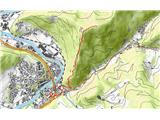
 | Kopačnica - Ermanovec
Ermanovec is a 1026 m high peak located between Cerkno and Gorenjska vasja, specifically above Sovodnje and Trebija. Just a few steps away from t...
1 h 40 min |
 | Gabrče - Vremščica
Vremščica is a mountain chain, stretching between Senožeče, Pivka and Divača. The highest top is also called Vremščica and the view from it is am...
2 h |
| Senožeče - Vremščica
Vremščica is a mountain chain, stretching between Senožeče, Pivka and Divača. The highest top is also called Vremščica and the view from it is am...
1 h 45 min |
 | Gornje Ležeče - Vremščica
Vremščica is a mountain chain, stretching between Senožeče, Pivka and Divača. The highest top is also called Vremščica and the view from it is am...
1 h 40 min |
 | Podgora - Vremščica
Vremščica is a mountain chain, stretching between Senožeče, Pivka and Divača. The highest top is also called Vremščica and the view from it is am...
2 h |
| Famlje - Vremščica
Vremščica is a mountain chain, stretching between Senožeče, Pivka and Divača. The highest top is also called Vremščica and the view from it is am...
2 h 30 min |
 | Podgorje - Slavnik (gentle path)
Slavnik is a scenic mountain rising south of Kozina and west of Podgorje. Podgorje is a village which is a suitable starting point for ascending ...
1 h 40 min |
 | Prešnica - Slavnik
Slavnik is a scenic mountain rising south of Kozina and west of Podgorje. Podgorje is a village which is a suitable starting point for ascending ...
2 h |
 | Vrtovin - Mala gora
Mala gora is a plateau on the slope of the Chavn. A hut is located at an altitude of 1034 metres. Mala gora is known for its flowers, which are u...
2 h 15 min |
 | Kočevje - Mestni vrh (Kalan way)
Mestni vrh is a 1034m high mountain located to the east of the hut at Jelenov Studenec. There is no view from the top where the registration box ...
1 h 30 min |
| Kočevje - Mestni vrh (Grajska way)
Mestni vrh is a 1034m high mountain located to the east of the hut at Jelenov Studenec. There is no view from the top where the registration box ...
1 h 40 min |
 | Slovenska vas - Slovenski vrh
Slovenski vrh is a 1041 metre high mountain located in the Stojna Ridge, a ridge located between the Kočevje River and Kočevje. The summit, which...
1 h 30 min |
 | Podbrdo - Kup
Kup is a 1046 m high peak located between Petrovy Brdo and Podbrdo. From the top, where there is a cross and a few transmitters, we have a beauti...
1 h 35 min |
 | Vrčice - Mirna gora (via Škrilj)
Mirna gora is a 1047 m high, forested peak located on the south-eastern edge of the Kočevje Horn. The summit, which has a registration box and a ...
2 h 10 min |
| Vrčice - Mirna gora (via Planina)
Mirna gora is a 1047 m high, forested peak located on the south-eastern edge of the Kočevje Horn. The summit, which has a registration box and a ...
2 h 10 min |
 | Rein - Mühlbacher Kogel (Hunting path / Jägersteig)
Mühlbacher Kogel is a 1050m high mountain in the western part of the Graz mountain range in Styria, Austria. It is located above the Mühlbacher H...
2 h 10 min |
 | Rein - Mühlbacher Kogel (via Hochstein)
Mühlbacher Kogel is a 1050m high mountain in the western part of the Graz mountain range in Styria, Austria. It is located above the Mühlbacher H...
2 h 30 min |
 | Radlje ob Dravi - Kapunar / Kapunerkogel
Kapunar is a 1051 m high peak above Radlje ob Dravi. Just below the peak is an old caravan and border guardhouse, which is now used by radio amat...
2 h 15 min |
 | Radlje ob Dravi - Kapunar / Kapunerkogel (via Župank)
Kapunar is a 1051 m high peak above Radlje ob Dravi. Just below the peak is an old caravan and border guardhouse, which is now used by radio amat...
2 h 30 min |
| Radlje ob Dravi - Kapunar / Kapunerkogel (via old castle)
Kapunar is a 1051 m high peak above Radlje ob Dravi. Just below the peak is an old caravan and border guardhouse, which is now used by radio amat...
2 h 30 min |
 | Volča - Malenski vrh
Malenski vrh is a 1051 m high mountain located west of Javorje. A small bench and cairn are located at the top, and the view of the surrounding h...
1 h 45 min |
 | Kočevje - Ledenik
At 1072 metres, Ledenik is the highest peak of Stojna, a forested ridge located between Kočevje and Kočevsko Rijeka. On the summit there is a reg...
2 h 15 min |
 | Gotenica - Kameni zid
Kameni zid are steep rocky cliffs descending steeply from Gotenická Gora. From the top of Kameni zid, we have a beautiful view towards Stojna, Ko...
1 h 30 min |
 | Frohnleiten - Haneggkogel (panoramic path)
...
2 h |
 | Zabukovica - Gozdnik
Gozdnik is a hill rising steeply above the village of Zabukovica. There is no view from the top, due to the forest, but there is a bivouac on it,...
1 h 45 min |
 | Beli Potok at Frankolovo - Stenica
Stenica is a 1091 m high peak located between Vitanje, Stranice and Frankolovi. There is no view from the top, which has a stamp with a registrat...
1 h 45 min |
 | Slovenska vas - Sveta Trojica
Sveta Trojica is a scenic peak located south-west of Javorniki. From the top, where the ruins of the former church are well preserved, you can en...
2 h 15 min |
 | Preserje - Krim
Krim is a 1107 m high mountain rising south of the Ljubljana Marshes. From the top of the mountain, where the mountain lodge and a number of tran...
2 h 20 min |
 | Dom v Iškem Vintgarju - Krim
Krim is a 1107 m high mountain rising south of the Ljubljana Marshes. From the top of the mountain, where the mountain lodge and a number of tran...
2 h 15 min |
 | Dolenja Brezovica - Krim
Krim is a 1107 m high mountain rising south of the Ljubljana Marshes. From the top of the mountain, where the mountain lodge and a number of tran...
2 h 10 min |
 | Iška - Krim
Krim is a 1107 m high mountain rising south of the Ljubljana Marshes. From the top of the mountain, where the mountain lodge and a number of tran...
2 h 10 min |
 | Cerknica - Slivnica
Slivnica is a 1114 m high peak located north of Cerknica polje. The view from the summit, where the entry box is located, is rather limited due t...
1 h 40 min |
 | Marija Reka (Strgar) - Mrzlica
Mrzlica has become an extremely popular excursion point in the last few years, especially for visitors from the Savinjska Valley and Zasavje. At ...
2 h 30 min |
| Matke - Mrzlica
Mrzlica has become an extremely popular excursion point in the last few years, especially for visitors from the Savinjska Valley and Zasavje. At ...
2 h 30 min |
| Podmrzlica, Matke - Mrzlica
Mrzlica has become an extremely popular excursion point in the last few years, especially for visitors from the Savinjska Valley and Zasavje. At ...
1 h 45 min |
 | Begunje (Krpin) - Smokuški vrh (by ski slope and via Sankaška koča)
Smokuški vrh is a scenic mountain located on a ridge between the Završnice valley and the Gorenjska plain. From the top of the hill, where there ...
1 h 40 min |
| Begunje (PGD Begunje) - Smokuški vrh (Petrova pot)
Smokuški vrh is a scenic mountain located on a ridge between the Završnice valley and the Gorenjska plain. From the top of the hill, where there ...
1 h 40 min |
 | Rakitnica - Bela stena
Bela stena (also just Stene) is a lookout point located west of Dolenje vas in the Ribnica valley, specifically above the village of Zadolje. Fro...
2 h 10 min |
 | Vrhnika pri Ložu - Racna gora
Racna gora is a little-visited peak rising east of the Loška dolina valley. There is no view from the summit, which has a registration box and a ...
1 h 45 min |
 | Gabrje - Trdinov vrh
Trdinov vrh is the highest point in the Gorjance mountain range. The view from the top is poor due to the forest, but you can still see part of t...
2 h |
 | Dolina Zaplaninščice - Črni vrh (Čemšeniška planina)
Črni vrh is the highest peak of Čemšeniška mountain pasture and with a height of 1204 m it is the second highest peak in the Posavje - Zasavje hi...
2 h 30 min |
 | Sopota - Kum (Nežina pot)
At 1220 metres, Kum is the highest peak of Posavsko hribovje. Because it rises above Zasavje, some people call it the Zasavje Triglav. On the sum...
2 h |
 | Laufnitzdorf - Schiffall
...
2 h 15 min |
 | Vrtovin - Kucelj na Čavnu
Kucelj is located on the southern slopes of Trnovo Forest, north-west of the Vipava valley. From the uncultivated summit on which the cross stand...
2 h 15 min |
 | Frohnleiten - Hochtrötsch (Trötsch)
...
2 h 15 min |
 | Razdrto - Vojkova koča na Nanosu (gentle path)
Vojkova koča is located on the southern edge of the Nanoše plateau, close to Pleše, a peak that is clearly visible from the motorway. From the hu...
2 h 20 min |
 | Veliko Ubeljsko - Vojkova koča na Nanosu
Vojkova koča is located on the southern edge of the Nanoše plateau, close to Pleše, a peak that is clearly visible from the motorway. From the hu...
1 h 45 min |
 | Bohinjska Bela (Podklanec) - Galetovec (western way)
Galetovec is an undistinguished peak in the south-eastern part of the Pokljuka plateau. From the summit, which has a registration box, there is a...
2 h |
 | Bohinjska Bela - Galetovec (via Turn)
Galetovec is an undistinguished peak in the south-eastern part of the Pokljuka plateau. From the summit, which has a registration box, there is a...
2 h |
 | Rakov Škocjan - Veliki Javornik (Javorniki)
Veliki Javornik is a 1,268-metre-high peak in the forested hills called the Javorniki. The vast forests of the Javorniki stretch from Postojna to...
2 h |
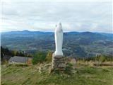
 | Vitanje - Basališče (Paški Kozjak)
Basališče is the highest peak of Paško Kozjak. There is a bench and a registration box at the top. Due to the forest, there is no view....
2 h 30 min |
 | Potoče - Potoška gora
The forested peak is located above Preddvor between Javorov vrh and the Iskra mountain lodge on Jakob. The summit has a bench and a registration ...
2 h |
 | Spodnja Kokra - Potoška gora
The forested peak is located above Preddvor between Javorov vrh and the Iskra mountain lodge on Jakob. The summit has a bench and a registration ...
2 h 5 min |
 | Bruck an der Mur - Hochanger (po cesti)
...
2 h |
 | Trdnjava Kluže - Kota 1313
Kota 1313 was the location of the Austro-Hungarian artillery observation post during the First World War. From position 1313, which is located in...
2 h 20 min |
 | Ljubenske Rastke - Bezovec
Bezovec is a lesser known peak located in the Smrekov Mountains. From the top of the peak, where the hunting observatory stands, we have a beauti...
2 h 15 min |