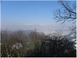
 | Trnovec - Polhograjska Grmada
Polhograjska Grmada is an 898 m high peak located in the heart of the Polhograjski Dolomites. From the summit, which has a registration box with ...
1 h 15 min |
 | Šmartno - Šmarna gora (Šmartinska way)
Šmarna gora is a 669 m high peak located north-west of Slovenia's capital. From the summit, which has a restaurant and a church, there is a beaut...
50 min |
 | Tacen - Šmarna gora (via Spodnja Kuhinja)
Šmarna gora is a 669 m high peak located north-west of Slovenia's capital. From the summit, which has a restaurant and a church, there is a beaut...
55 min |
 | Vikrče - Šmarna gora (via Zatrep)
Šmarna gora is a 669 m high peak located north-west of Slovenia's capital. From the summit, which has a restaurant and a church, there is a beaut...
1 h 10 min |
 | Tacen - Šmarna gora (Partizanska steza)
Šmarna gora is a 669 m high peak located north-west of Slovenia's capital. From the summit, which has a restaurant and a church, there is a beaut...
1 h |
| Tacen (Sveti Jurij) - Šmarna gora (Romarska pot)
Šmarna gora is a 669 m high peak located north-west of Slovenia's capital. From the summit, which has a restaurant and a church, there is a beaut...
1 h |
| Tacen (Sveti Jurij) - Šmarna gora (Partizanska steza)
Šmarna gora is a 669 m high peak located north-west of Slovenia's capital. From the summit, which has a restaurant and a church, there is a beaut...
1 h |
| Lipa - Šmarna gora (path via Peski)
Šmarna gora is a 669 m high peak located north-west of Slovenia's capital. From the summit, which has a restaurant and a church, there is a beaut...
55 min |
| Lipa - Šmarna gora (by road)
Šmarna gora is a 669 m high peak located north-west of Slovenia's capital. From the summit, which has a restaurant and a church, there is a beaut...
1 h 5 min |
 | Vikrče - Šmarna gora (Kovačeva steza)
Šmarna gora is a 669 m high peak located north-west of Slovenia's capital. From the summit, which has a restaurant and a church, there is a beaut...
1 h 10 min |
| Vikrče - Šmarna gora (learning trail)
Šmarna gora is a 669 m high peak located north-west of Slovenia's capital. From the summit, which has a restaurant and a church, there is a beaut...
1 h 20 min |
| Spodnje Pirniče - Šmarna gora (Kovačeva steza)
Šmarna gora is a 669 m high peak located north-west of Slovenia's capital. From the summit, which has a restaurant and a church, there is a beaut...
1 h 10 min |
| Spodnje Pirniče - Šmarna gora (learning trail)
Šmarna gora is a 669 m high peak located north-west of Slovenia's capital. From the summit, which has a restaurant and a church, there is a beaut...
1 h 10 min |
 | Legastja - Sveti Jakob
The Church of St James is located on a hill north of the village of Topol near Medvode. From the top, where there is a registration box with a st...
1 h 10 min |
 | Legastja - Sveti Jakob (north path)
The Church of St James is located on a hill north of the village of Topol near Medvode. From the top, where there is a registration box with a st...
1 h |
 | Jablje Castle - Rašica (Vrh Staneta Kosca)
Vrh Staneta Kosca, better known as Rašica, is located north of Ljubljana, specifically above the villages of Rašica and Dobeno. From the top of t...
1 h 20 min |
| Loka - Rašica (Vrh Staneta Kosca)
Vrh Staneta Kosca, better known as Rašica, is located north of Ljubljana, specifically above the villages of Rašica and Dobeno. From the top of t...
1 h 20 min |
 | Selo pri Vodicah - Rašica (Vrh Staneta Kosca) (old path)
Vrh Staneta Kosca, better known as Rašica, is located north of Ljubljana, specifically above the villages of Rašica and Dobeno. From the top of t...
1 h 15 min |
 | Selo pri Vodicah - Rašica (Vrh Staneta Kosca) (by road)
Vrh Staneta Kosca, better known as Rašica, is located north of Ljubljana, specifically above the villages of Rašica and Dobeno. From the top of t...
1 h 20 min |
 | Rakovica - Sveti Jošt above Kranj
Sveti Jošt above Kranj, is a hill located to the west of the slightly lower Šmarjetna Gora. From the top, where the Church of St. Jošto and the J...
1 h 20 min |
 | Pševo - Sveti Jošt above Kranj (Sodarjeva pot, past the chapel)
Sveti Jošt above Kranj, is a hill located to the west of the slightly lower Šmarjetna Gora. From the top, where the Church of St. Jošto and the J...
50 min |
| Tičnica - Sveti Jošt above Kranj (Pot prijateljev Sv. Jošta, on stairs)
Sveti Jošt above Kranj, is a hill located to the west of the slightly lower Šmarjetna Gora. From the top, where the Church of St. Jošto and the J...
1 h 15 min |
| Tičnica - Sveti Jošt above Kranj (Pot prijateljev Sv. Jošta, na klopca)
Sveti Jošt above Kranj, is a hill located to the west of the slightly lower Šmarjetna Gora. From the top, where the Church of St. Jošto and the J...
1 h 15 min |
| Tičnica - Sveti Jošt above Kranj (Pot prijateljev Sv. Jošta, past the chapel)
Sveti Jošt above Kranj, is a hill located to the west of the slightly lower Šmarjetna Gora. From the top, where the Church of St. Jošto and the J...
1 h 20 min |
 | Trnovec - Osolnik (by road)
Osolnik is an 858 m high mountain located south of Škofja Loka and west of Medvode. From the top, where the Church of St. Mohor and Fortunatus st...
1 h 20 min |
 | Trnovec - Osolnik (via Mavški graben)
Osolnik is an 858 m high mountain located south of Škofja Loka and west of Medvode. From the top, where the Church of St. Mohor and Fortunatus st...
1 h 15 min |
| Trnovec - Osolnik (via Govejski graben)
Osolnik is an 858 m high mountain located south of Škofja Loka and west of Medvode. From the top, where the Church of St. Mohor and Fortunatus st...
1 h 15 min |
 | Polhov Gradec (Blagajev grad) - Polhograjska Gora (Sveti Lovrenc)
Polhograjska Gora, also just Gora or Sveti Lovrenc, is an 824 m high hill located north-west of Polhov Gradec. From the top of the hill, where th...
1 h 5 min |
 | Polhov Gradec (Blagaj Castle) - Polhograjska Gora (Sveti Lovrenc) (via castle water catchment)
Polhograjska Gora, also just Gora or Sveti Lovrenc, is an 824 m high hill located north-west of Polhov Gradec. From the top of the hill, where th...
1 h 10 min |
| Polhov Gradec (Blagaj Castle) - Polhograjska Gora (Sveti Lovrenc) (by cart track)
Polhograjska Gora, also just Gora or Sveti Lovrenc, is an 824 m high hill located north-west of Polhov Gradec. From the top of the hill, where th...
1 h 15 min |
 | Vrzdenec - Kožljek
Kožljek is a 788 m high peak located to the west of Koreno, specifically above the village of Samotorica. From the top, where there are a few ben...
1 h 5 min |
 | Preval Prosca - Koreno (gentle path)
Koreno also Koreno is a 729 m high hill located north of Horjul. From the top, where there is a large cross, the Church of St. Mohorj and Fortuna...
1 h 15 min |
 | Preval Prosca - Koreno (steep path)
Koreno also Koreno is a 729 m high hill located north of Horjul. From the top, where there is a large cross, the Church of St. Mohorj and Fortuna...
1 h |
 | Horjul - Koreno (gentle path)
Koreno also Koreno is a 729 m high hill located north of Horjul. From the top, where there is a large cross, the Church of St. Mohorj and Fortuna...
1 h 5 min |
 | Briše - Koreno
Koreno also Koreno is a 729 m high hill located north of Horjul. From the top, where there is a large cross, the Church of St. Mohorj and Fortuna...
50 min |
| Horjul - Koreno (steep path)
Koreno also Koreno is a 729 m high hill located north of Horjul. From the top, where there is a large cross, the Church of St. Mohorj and Fortuna...
1 h |
 | Zaklanec - Koreno
Koreno also Koreno is a 729 m high hill located north of Horjul. From the top, where there is a large cross, the Church of St. Mohorj and Fortuna...
1 h 15 min |
 | Srednja vas - Koreno
Koreno also Koreno is a 729 m high hill located north of Horjul. From the top, where there is a large cross, the Church of St. Mohorj and Fortuna...
1 h 20 min |
 | Sora - Hom (footpath)
Hom is a 715 m high peak rising steeply south-west of the village of Sora. The summit, which is partly covered with forest, offers a beautiful vi...
50 min |
 | Sora - Hom (by road)
Hom is a 715 m high peak rising steeply south-west of the village of Sora. The summit, which is partly covered with forest, offers a beautiful vi...
1 h 5 min |
 | Sora - Hom (less steep path)
Hom is a 715 m high peak rising steeply south-west of the village of Sora. The summit, which is partly covered with forest, offers a beautiful vi...
55 min |
 | Skalnica - Sveta Gora (by road)
Sveta Gora is known mainly by the faithful and locals. Sveta Gora is a well-known pilgrimage centre above Nova Gorica. It is visited by believers...
1 h |
 | Skalnica - Sveta Gora (footpath)
Sveta Gora is known mainly by the faithful and locals. Sveta Gora is a well-known pilgrimage centre above Nova Gorica. It is visited by believers...
55 min |
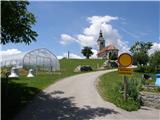
 | Šmartno - Grmada
Grmada is a 676 m high mountain located to the west of the much more visited Šmarna Gora. From the top, where there is a small airstrip, we have ...
55 min |
| Tacen - Grmada (via Spodnja Kuhinja)
Grmada is a 676 m high mountain located to the west of the much more visited Šmarna Gora. From the top, where there is a small airstrip, we have ...
1 h |
 | Vikrče - Grmada (via Zatrep)
Grmada is a 676 m high mountain located to the west of the much more visited Šmarna Gora. From the top, where there is a small airstrip, we have ...
1 h 15 min |
 | Vikrče - Grmada (Mazijeva steza)
Grmada is a 676 m high mountain located to the west of the much more visited Šmarna Gora. From the top, where there is a small airstrip, we have ...
1 h 5 min |
| Tacen - Grmada (Mazijeva steza)
Grmada is a 676 m high mountain located to the west of the much more visited Šmarna Gora. From the top, where there is a small airstrip, we have ...
1 h 10 min |
| Tacen (Sveti Jurij) - Grmada
Grmada is a 676 m high mountain located to the west of the much more visited Šmarna Gora. From the top, where there is a small airstrip, we have ...
1 h 5 min |
 | Vikrče - Grmada (Kovačeva steza)
Grmada is a 676 m high mountain located to the west of the much more visited Šmarna Gora. From the top, where there is a small airstrip, we have ...
1 h 10 min |
 | Lipa - Grmada (path via Peski)
Grmada is a 676 m high mountain located to the west of the much more visited Šmarna Gora. From the top, where there is a small airstrip, we have ...
1 h |
| Lipa - Grmada (by road)
Grmada is a 676 m high mountain located to the west of the much more visited Šmarna Gora. From the top, where there is a small airstrip, we have ...
1 h 10 min |
| Vikrče - Grmada (on Kovačeva steza and over Sedlo)
Grmada is a 676 m high mountain located to the west of the much more visited Šmarna Gora. From the top, where there is a small airstrip, we have ...
1 h 15 min |
| Vikrče - Grmada (learning trail)
Grmada is a 676 m high mountain located to the west of the much more visited Šmarna Gora. From the top, where there is a small airstrip, we have ...
1 h 20 min |
| Spodnje Pirniče - Grmada (learning trail)
Grmada is a 676 m high mountain located to the west of the much more visited Šmarna Gora. From the top, where there is a small airstrip, we have ...
1 h 15 min |
| Spodnje Pirniče - Grmada (on Kovačeva steza and over Sedlo)
Grmada is a 676 m high mountain located to the west of the much more visited Šmarna Gora. From the top, where there is a small airstrip, we have ...
1 h 15 min |
 | Polhov Gradec (Blagaj Castle) - Mali vrh
To the west of Polhov Gradec, between the rivers Mala voda and Velika Božna, is a 708-metre-high hill called Mali vrh. From the grassy summit, wh...
1 h 20 min |
 | Krašnja - Limbarska gora
Limbarska gora is located north-east of Moravce. From the top there is a beautiful view of the surrounding peaks and in good weather you can also...
1 h 15 min |
 | Praprotno - Archangel Gabriel (Planica)
Planica is an 824 m high peak located north of Škofja Loka, between Krizna Gora and Planica. From the top, where the Church of St. Gabriel the Ar...
1 h 20 min |
 | Star maln - Koča na Planini nad Vrhniko
Planina above Vrhnika is for hers inhabitants something like Šmarna gora for inhabitants of Ljubljana. It is 733 metres high and is reachable fro...
1 h |
 | Blatni dol - Koča na Planini nad Vrhniko
Planina above Vrhnika is for hers inhabitants something like Šmarna gora for inhabitants of Ljubljana. It is 733 metres high and is reachable fro...
1 h 10 min |
 | Vrhnika - Koča na Planini nad Vrhniko (via bukev)
Planina above Vrhnika is for hers inhabitants something like Šmarna gora for inhabitants of Ljubljana. It is 733 metres high and is reachable fro...
1 h 5 min |
 | Vrhnika - Koča na Planini nad Vrhniko (via Špica)
Planina above Vrhnika is for hers inhabitants something like Šmarna gora for inhabitants of Ljubljana. It is 733 metres high and is reachable fro...
1 h |
 | Stara Vrhnika - Koča na Planini nad Vrhniko (via Kuren)
Planina above Vrhnika is for hers inhabitants something like Šmarna gora for inhabitants of Ljubljana. It is 733 metres high and is reachable fro...
1 h 15 min |
| Stara Vrhnika - Koča na Planini nad Vrhniko (via Špica)
Planina above Vrhnika is for hers inhabitants something like Šmarna gora for inhabitants of Ljubljana. It is 733 metres high and is reachable fro...
1 h 15 min |
 | Kuren - Ulovka
Ulovka is the peak between Zaplana and the Shelter at Mountain pasture above Vrhnika. From the top, which is reached by ski lifts, there is a nic...
50 min |
 | Hotovlja - Bukov vrh (footpath)
Bukov vrh, on which the Church of the Sorrowful Mother of God stands, is located in the north-western part of the Polhograje hills. From the top ...
1 h |
 | Dolenja vas (Kosmulj) - Ključ
Ključ is a forested peak located north of Brezje pri Dobrovi and south of Dolenje vas. There is no view from the top where the registration box w...
1 h 10 min |
 | Podgorje - Kojnik (steep path)
Kojnik is a partially vegetated peak located in the southern part of the Podgorje Karst near the Slovenian-Croatian border. From the top of the s...
1 h |
 | Zazid - Kojnik
Kojnik is a partially vegetated peak located in the southern part of the Podgorje Karst near the Slovenian-Croatian border. From the top of the s...
1 h 20 min |
 | Širje - Dom v Gorah
The mountain lodge in Gora is located east of Hrastnik, just a few metres below the 786m-high peak on which the Church of St George stands. From ...
1 h 20 min |
| Krnice - Dom v Gorah
The mountain lodge in Gora is located east of Hrastnik, just a few metres below the 786m-high peak on which the Church of St George stands. From ...
1 h 5 min |
 | Marno - Dom v Gorah
The mountain lodge in Gora is located east of Hrastnik, just a few metres below the 786m-high peak on which the Church of St George stands. From ...
1 h 15 min |
 | Kekec - Škabrijel
Škabrijel is an peak north-east of the town of Gorizia. Since the vegetation has been cleared and a tall metal lookout tower erected at the top, ...
50 min |
 | Prevala - Škabrijel (via Veliki hrib)
Škabrijel is an peak north-east of the town of Gorizia. Since the vegetation has been cleared and a tall metal lookout tower erected at the top, ...
1 h 5 min |
| Prevala - Škabrijel
Škabrijel is an peak north-east of the town of Gorizia. Since the vegetation has been cleared and a tall metal lookout tower erected at the top, ...
50 min |
| Prevala - Škabrijel (via Hungarian pyramid)
Škabrijel is an peak north-east of the town of Gorizia. Since the vegetation has been cleared and a tall metal lookout tower erected at the top, ...
1 h |
 | Dobrič - Gora Oljka
Gora Oljka is a hill located east of Šmartno ob Paki. On the top stands the Church of the Holy Cross, which was built in the mid-18th century. Ju...
50 min |
 | Rečica ob Paki - Gora Oljka
Gora Oljka is a hill located east of Šmartno ob Paki. On the top stands the Church of the Holy Cross, which was built in the mid-18th century. Ju...
1 h 15 min |
| Podgora - Gora Oljka (Martin way)
Gora Oljka is a hill located east of Šmartno ob Paki. On the top stands the Church of the Holy Cross, which was built in the mid-18th century. Ju...
1 h 20 min |
 | Dobrič (Vedet) - Gora Oljka (via Brezovec)
Gora Oljka is a hill located east of Šmartno ob Paki. On the top stands the Church of the Holy Cross, which was built in the mid-18th century. Ju...
50 min |
 | Matke - Golava
Golava is a peak located north of Mrzlica. From the summit, on which a small bivouac (Blaž's bivouac) stands, there is a beautiful view towards t...
1 h 15 min |
 | Zvodno - Srebotnik (on Celje mountain trail)
Srebotnik is a lightly vegetated peak located south of Celje and Štore in the Posavje Hills. From the top, which has a registration box and a sma...
1 h 15 min |
 | Žička kartuzija - Skala
Skala is a viewpoint on the eastern part of Konjiška Gora. From the viewpoint, which has a table, bench and a registration box, there is a beauti...
1 h |
 | Gabrje - Rog
The Rog is a 798 m high peak located above the village of Topole, just 10 minutes from St Catherine's Church. From the top of the hill, where a l...
1 h 20 min |
 | Legastja - Rog
The Rog is a 798 m high peak located above the village of Topole, just 10 minutes from St Catherine's Church. From the top of the hill, where a l...
1 h 15 min |
 | Tržič - Kamnek (Radetzky way)
Kamnek (Kamnik on maps, but also Kamnjek) is a scenic peak above Tržič....
1 h |
 | Podgora - Kamen vrh
Kamen vrh is a scenic peak located on the northern outskirts of Mala Gora. From the top, surrounded by low bushes, there is a beautiful view of p...
1 h |
 | Podpeč - Kamen vrh
Kamen vrh is a scenic peak located on the northern outskirts of Mala Gora. From the top, surrounded by low bushes, there is a beautiful view of p...
50 min |
 | Podgora - Grmada on Mala gora
Grmada (also Grmada nad Ortnek) is an 887 m high peak located above the village of Vrh pri Poljanah in the Mala Gora mountain range. Just a few m...
1 h 20 min |
 | Bresternica (Šoberjev dvor) - Tojzlov vrh
Tojzlov vrh is a forested hill located in the eastern part of Kozjak. On the top of the hill stands a small stone monument to the National Libera...
1 h 15 min |
 | Šober - Tojzlov vrh
Tojzlov vrh is a forested hill located in the eastern part of Kozjak. On the top of the hill stands a small stone monument to the National Libera...
1 h |
 | Kamnica - Murovica
Murovica is a popular excursion point, accessible from the Posavina side, Domžale or from the Moravška valley. There is a bench and a registratio...
1 h 20 min |
 | Zgornja Rečica (church of Blessed Anton Martin Slomšek) - Govško brdo
Govško brdo is an 811m high hill located west of the village of Huda jama above Laško. From the top of the hill, where the registration box and s...
1 h 15 min |
 | Adergas - Štefanja gora (via benches)
Štefanja gora on which the Church of St Stephen stands, is located above Cerkly in Gorenjska. Just 10 metres below the summit, the Pr'Mežnarju ex...
1 h |
 | Adergas - Štefanja gora (via šterna)
Štefanja gora on which the Church of St Stephen stands, is located above Cerkly in Gorenjska. Just 10 metres below the summit, the Pr'Mežnarju ex...
1 h |
 | Olševek - Štefanja gora
Štefanja gora on which the Church of St Stephen stands, is located above Cerkly in Gorenjska. Just 10 metres below the summit, the Pr'Mežnarju ex...
55 min |
 | Velesovo - Štefanja gora (via benches)
Štefanja gora on which the Church of St Stephen stands, is located above Cerkly in Gorenjska. Just 10 metres below the summit, the Pr'Mežnarju ex...
1 h 10 min |
| Velesovo - Štefanja gora (via Šterna)
Štefanja gora on which the Church of St Stephen stands, is located above Cerkly in Gorenjska. Just 10 metres below the summit, the Pr'Mežnarju ex...
1 h 10 min |
 | Belica - Kregovnik
Kregovnik is a lesser known peak located on the south-eastern ridge of the 898 m high Polhograjska Grmada. The summit, which is mostly forested, ...
1 h |
 | Polhov Gradec (Božna) - Mala Grmada (via Setnica)
Mala Grmada is an 853 m high peak located south-west of the slightly higher Polhograjska Grmada. From the top, you have a beautiful view over the...
1 h 15 min |
 | Ljubljanica - Sveti Andrej (Planina above Horjul)
The Church of St Andrew is situated on a lookout hill just above the Mountain pasture above Horjul. The church, which was built in 1659, offers a...
1 h 15 min |
 | Preska - Sveti Florijan (Tehovec)
The Church of St Florian is a branch church located in the village Tehovec above Medvode. The church, which was first mentioned in 1548, offers a...
1 h 15 min |
| Sora - Sveti Florijan (Tehovec)
The Church of St Florian is a branch church located in the village Tehovec above Medvode. The church, which was first mentioned in 1548, offers a...
1 h 15 min |
 | Legastja - Sveti Florijan (Tehovec)
The Church of St Florian is a branch church located in the village Tehovec above Medvode. The church, which was first mentioned in 1548, offers a...
50 min |
 | Kropa - Sveti Primož in Felicijan (Jamnik)
The Church of St. Primož and Felicijan on Jamnik, is situated on a scenic grassy ridge rising between Kropa and Podblica. From the church or its ...
1 h 10 min |
 | Rovte - Sveti Primož in Felicijan (Jamnik)
The Church of St. Primož and Felicijan on Jamnik, is situated on a scenic grassy ridge rising between Kropa and Podblica. From the church or its ...
1 h 15 min |
 | Češnjica pri Kropi - Sveti Primož in Felicijan (Jamnik)
The Church of St. Primož and Felicijan on Jamnik, is situated on a scenic grassy ridge rising between Kropa and Podblica. From the church or its ...
1 h 15 min |
 | Prelska - Vinska gora
Vinska gora, marked on some maps as neighbouring Temnjak, is an 806 m high hill located north-west of Dobrnež and north-east of Vinská Gora. The ...
1 h 20 min |
 | Kolovrat - Reber
Reber is an 878 m high peak located south-west of Trojany. On the summit, which has a registration box with a registration book and a stamp, ther...
1 h |
 | Narin - Šilentabor
Šilentabor is a 751 m high peak located just above the village of the same name. From the top, near which there is also a bench and a registratio...
1 h |
 | Krvavi Potok - Veliko Gradišče
Veliko Gradišče is a 742 m high peak located south of the village of Lokev in the Karst and east of Kokoši. From the top, on which stands a concr...
1 h |
 | Log - Pečke (steep path)
Pečke is an easily accessible and recently less and less visited peak located north of the main ridge of Pohorje. It receives more visitors only ...
1 h |
 | Loka pri Žusmu (Žamerk) - Žusem
Žusem is a 669-metre-high hill with a colourful history and great potential for the future. It represents the northern edge of the Kozjansko regi...
1 h 20 min |
 | Velesovo - Apnišče (via Šterna)
Apnišče is a 740 m high mountain located between Možjanca and Štefanja gora. It is the highest point of the Šenčur municipality. There is a bench...
1 h 10 min |
 | Hunting cottage Budanje - Sončnica (Reber)
Sončnica is a paragliding airstrip on the outskirts of the Gora plateau or Reber Ridge. There are a few benches, an automatic weather station Kov...
1 h 10 min |
 | Poljana - Volinjak (via Stovčnik)
Volinjak (misnamed Volinjek on some maps) is an 886-metre-high peak located between Mežica and Prevalje. From the top, where there is a registrat...
1 h 15 min |
| Leše - Volinjak (via Hermanko)
Volinjak (misnamed Volinjek on some maps) is an 886-metre-high peak located between Mežica and Prevalje. From the top, where there is a registrat...
1 h 5 min |
| Leše - Volinjak (via Prapar)
Volinjak (misnamed Volinjek on some maps) is an 886-metre-high peak located between Mežica and Prevalje. From the top, where there is a registrat...
1 h 5 min |
 | Mežica - Volinjak
Volinjak (misnamed Volinjek on some maps) is an 886-metre-high peak located between Mežica and Prevalje. From the top, where there is a registrat...
1 h 10 min |
 | Gorenja vas - Jermanca (Jermancov grič)
Jermanca, on maps Jermanca hill, is a lookout point above Gorenjska vasje. In good weather, the summit offers a beautiful view of the peaks above...
55 min |
 | Križe - Planica (Paragliding site Gozd)
Planica is a 926-metre-high peak located above the village of Gozd. From the top, where the JPK Kriška gora hut is located, we have a beautiful v...
1 h 20 min |
| Tržič - Planica (Paragliding site Gozd)
Planica is a 926-metre-high peak located above the village of Gozd. From the top, where the JPK Kriška gora hut is located, we have a beautiful v...
1 h 20 min |
 | Moravče - Gorišca
Gorišca is a 698-metre-high peak located south-west of the Ušte - Žerenk Mountain Lodge. The summit, on which the converter stands, offers no bet...
1 h 15 min |
 | Jablance - Grmada (Bohor)
The Grmada Peak is located on the slope of Bohor. The summit is not scenic, but it is easily accessible. There is a partisan hospital nearby....
1 h 20 min |
 | Škale - Lubela (via hunting lodge)
Lubela is a hill at Velenje, rising north above the Šaleška dolina and belonging to the Šentviška hills or the wider area of the Graška Gora.On t...
1 h 15 min |
 | Predgrad - Kozice
Kozice is a 741-metre-high peak with an RTV transmitter located above the left bank of the Kolpa River. From the lookout point on the southern pe...
1 h 15 min |
 | Socka - Kozjek (above Socka)
Kozjek) is an interesting peak, lying west of the ridge-like Kislica as a kind of pointed extension with precipitous walls on its western side. I...
1 h 10 min |
 | Jablance - Plešivec (Bohor)
Plešivec, also known as Špic hill on some maps, is a 915 m high peak in Bohor, located southeast of the Bohor Cottage....
1 h 5 min |
 | Zreče (cemetery) - Golek
Golek is a 769-metre-high peak located north-west of Zreče. At the top there is a registration box with a registration book, a stamp and a bench,...
1 h 15 min |
 | Stubenbergsee - Kulmkögerl (Kulmgipfel)
Kulmkögerl is an 866-metre-high peak located above Lake Stubenbergsee. A wooden cross and a registration box stand at the top....
1 h 20 min |
 | Straßengel - Frauenkogel
...
1 h 10 min |
| Šentjanž - Leskovški hrib
...
1 h |
 | Radegunda (Žekovec) - Sveta Radegunda (Radegunda)
...
1 h 15 min |