Starting point: Sora (360 m)
| Lat/Lon: | 46,1414°N 14,3703°E |
| |
Name of path: footpath
Time of walking: 50 min
Difficulty: easy marked way
Altitude difference: 355 m
Altitude difference po putu: 355 m
Map: Ljubljana - okolica 1:50.000
Recommended equipment (summer):
Recommended equipment (winter):
Views: 21.355
 | 4 people like this post |
Access to the starting point:
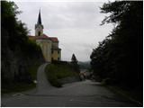
a) First drive to Medvode, then leave the main road at the Špar shop and continue towards the railway station and Sora. In Sora, the road to Katarina turns first left, and a little further on to Osolnik. Take the road to Osolnik and after a short climb park in the parking lot below St Stephen's Church. You can also park a little further down in the parking lot next to the parish church.
b) From Kranj, drive towards Škofja Loka, and from the outskirts of Škofja Loka follow the signs for Gorenjska vas. Before the Sten tunnel, take the exit from the roundabout towards Sora. Continue through Hosta, Pungert, Gosteče and Draga to Sora, where you turn right towards Osolnik and then, after a short climb, park in the parking lot below St Stephen's Church. You can also park a little further down in the parking lot next to the parish church.
c) From Poljanska dolina, drive towards Škofja Loka and then take the ring road and go through the Sten tunnel. Turn right after the tunnel and follow the signs for Sora. Continue through Hosta, Pungert, Gosteče and Draga to Sora, where you turn right towards Osolnik and then, after a short climb, park in the parking lot under St Stephen's Church. You can also park a little further down in the parking lot next to the parish church.
Path description:
From the parking lot at St Stephen's Church, continue along the asphalted road, which climbs moderately and, after a short ascent, leads to a sharp left-hand bend. Just slightly above the bend, a marked footpath branches off the road sharply to the right, leading to Hom and Osolnik. Take the above-mentioned path, which goes into a dense forest and starts to climb steeply. Higher up, the path briefly flattens out and comes fully close to the road to Osolnik.
Continue slightly to the right on the marked mountain path, which splits into two parts a little higher up. Continue right again in the direction of Homa (slightly to the left Osolnik - a path which bypasses the summit of Homa on the left) on an increasingly steep path. The path is higher, and then in a few minutes of further walking leads us to the top of Homa, from which we open a beautiful view towards Gorenjska.
We can extend the trip to the following destinations: Osolnik (1 h)
Pictures:
 1
1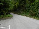 2
2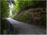 3
3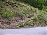 4
4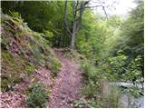 5
5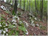 6
6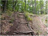 7
7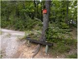 8
8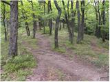 9
9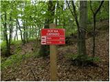 10
10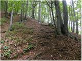 11
11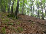 12
12 13
13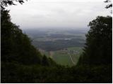 14
14
Discussion about the trail Sora - Hom (footpath)
|
| Guest27. 11. 2007 |
Iz Homa nadaljujemo pot na razgleden Osolnik (45 min.),od tod pa čez Gontarsko planino na Tošč in na Grmado. Pridni hodci pa lahko gredo naprej na Katarino, Sv.Jakob in naprej po robu nazaj v Soro. Taka pot traja okrog 7 ur, je zelo lepa, z pogledi enkrat na Gorenjsko s Grintovci, pa na Škofjo Loko,proti Ljubljani. Pot lahko končamo prej, saj več označenih poti pelje v dolino Ločnice in na izhodišče.Zelo lepe poti tudi za zimski čas.ki prihaja.
|
|
|
|
| mcatar14. 11. 2010 |
S kolegom in otroci smo imeli prav lep izlet. Pot je na posameznih delih kar strma, zgornji del pod vrhom je kar malce prestrm za naša šestletnika, ne preveč vajena hribov. V dolino smo se spustili po drugi strani hriba (držali smo se leve markirane poti in ne desne proti Osolniku). Po nekaj deset metrih spusta smo se na razpotju obrnili nazaj proti Sori. Spust po zahodni strani Homa je precej položnejši in ga lahko uporabite tudi za vzpon. GPS sled izleta lahko dobite na: http://www.everytrail.com/view_trip.php?trip_id=884004
|
|
|
|
| KristinaG14. 11. 2010 |
GSP sledi ne morem videti, ker je "privat", po opisu si pa bolj težko predstavljam kje ste šli. Predvidevam pa da ste šli gor po krajši poti (označba Hom 15 minut). Za otroke je lepše, če tu ne bi zavili desno, ampak bi se držali leve. In potem višje gor, pri označbi zavili desno. Je pa tudi tu potka morda na enem delu malo strma (za otroke).
|
|
|
|
| Alias989814. 07. 2017 |
Lušten hrib in luštna pot. So pa zadnji metri res občutno bolj strmi in skoraj malo presenetijo. Če so otroci vajeni ni težave, če pa ne, pa se malo popazi, da ne pristanejo na kolenih in je čisto v redu. Razgled je čudovit, najmanj zato se splača 
|
|
|
|
| di9. 04. 2025 17:55:57 |
Osvojeni so bili hribi:
Brezje, Hom, Žebnik
|
|
|