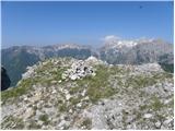
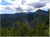
 | Križe - Tolsti vrh (Ovčja pot over Kriška gora)
Tolsti vrh, located to the west of Storžič, is also the highest peak of the Kriška Gora, a mountain range rising steeply above the central Gorenj...
3 h 45 min |
 | Tominčev slap Waterfall - Dobrča
Dobrča is a 1634 m high mountain located between Begunje and Tržič. From the top, where the registration box with the stamp is located, we can se...
3 h |
 | Draga - Dobrča (via Ledena trata)
Dobrča is a 1634 m high mountain located between Begunje and Tržič. From the top, where the registration box with the stamp is located, we can se...
3 h |
 | Grahovše - Veliki Javornik (Ženiklovec)
Veliki Javornik or Ženiklovec is a 1716 m high peak located between Storžič and Stegovnik. From the grassy summit, where the registration box is ...
2 h 45 min |
 | Grahovše - Veliki Javornik (Ženiklovec) (via Rekar)
Veliki Javornik or Ženiklovec is a 1716 m high peak located between Storžič and Stegovnik. From the grassy summit, where the registration box is ...
2 h 45 min |
 | Kraljev hrib - Rzenik (west path)
Rzenik is a grassy peak surrounded by dwarf pines, which descends precipitously towards the Kamniška Bela valley. From the top, in fine weather, ...
3 h 40 min |
 | Spodnja Kokra - Srednji vrh (via Baba)
Srednji vrh is an 1853 m high mountain located to the east of Storžič. From the top, where there is a bench, a registration box and a stamp, we h...
4 h 10 min |
 | Potoče - Javorov vrh (via Sveti Jakob, below Potoška gora and over Baba)
Javorov vrh (also Javorjev vrh according to some records) is a 1434 m high mountain located northeast of Preddvor. From the top, which has a regi...
2 h 55 min |
 | Mače - Bašeljski vrh (via valley of Suha and via Kališče)
Bašeljski vrh is a 1744 m high mountain located between Mali Grintovec and Storžič. From the top, where there is a bench and a registration box w...
3 h 15 min |
 | Rosenbach - Frauenkogel/Dovška Baba (via Hruški vrh)
Frauenkogel is an 1891 m high peak located on the border ridge between Slovenia and Austria. The summit, which has a registration box and a stamp...
4 h 40 min |
| Rosenbach - Frauenkogel/Dovška Baba (via Koprivnjak)
Frauenkogel is an 1891 m high peak located on the border ridge between Slovenia and Austria. The summit, which has a registration box and a stamp...
4 h 30 min |
| Dovje - Frauenkogel/Dovška Baba (via Blažčeva skala)
Frauenkogel is an 1891 m high peak located on the border ridge between Slovenia and Austria. The summit, which has a registration box and a stamp...
3 h 15 min |
 | Smrečje - Pečovnik (survey point 1668) (by road)
Pečovnik) is a 1668 m high mountain located between Plešivec (1801 m) and Virnik's Grintovec (1654 m). The grassy peak, located on the border bet...
2 h 45 min |
 | Smrečje - Plešivec (by road)
Plešivec is an 1801 m high peak located south of the eastern part of Košuta. The summit, on which the border signpost stands, offers a beautiful ...
3 h 30 min |
 | Rosenbach - Klek
Klek is a 1753 m high mountain located between Rosenkogel and the more famous Golica. The summit, which borders between Slovenia and Austria, off...
3 h 40 min |
 | Kraljev hrib - Koritni vrh (Velika planina)
Koritni vrh is a 1648 m high mountain located in the northern part of Velika planina. From the top, on which stands a small cross, a beautiful vi...
3 h |
 | Bela Peč - Vivodnik (past peak Seduc)
At 1508 m, Vivodnik is the highest peak of the Menina mountain pasture, a plateau rising south of Gornji Grad. From the top, where there is a sma...
4 h 20 min |
| Bela Peč - Vivodnik (via Ovčje jame)
At 1508 m, Vivodnik is the highest peak of the Menina mountain pasture, a plateau rising south of Gornji Grad. From the top, where there is a sma...
4 h 25 min |
 | Mojstrana - Drobeče Sleme
The summit is located in the same ridge as the better known Sleme. There is also a registration box with a registration book on the lookout point...
4 h 15 min |
 | Mojstrana - Vrtaški vrh (old path)
Vrtaški vrh is a scenic mountain overloking the Vrata valley. From the grassy summit, which is covered around and around with dwarf pines, there ...
3 h 30 min |
 | Javorje (Mala Črna) - Komen (via Hlipovec)
At 1684m, Komen is the highest peak of the Smrekov Mountains, a mountain range bordering Styria and Carinthia. From the top, in good weather, we ...
4 h 20 min |
 | Javorje (Mala Črna) - Veliki Travnik (Turnovka) (strma pot)
Veliki Travnik, or Turnovka as the locals call it, is located on the western edge of the Smrekov Mountains. From the top of the hill, where a woo...
4 h 25 min |
 | Potoče - Cjanovca (via Sveti Jakob, below Potoška gora and over Baba)
Cjanovca is the peak east of Storžič and south of Sredni vrh. It is a peak that can be seen from Kranj and the surrounding area. The southern slo...
4 h 30 min |
| Spodnja Kokra - Cjanovca (via Baba)
Cjanovca is the peak east of Storžič and south of Sredni vrh. It is a peak that can be seen from Kranj and the surrounding area. The southern slo...
3 h 55 min |
 | Ivarčko jezero - Uršlja gora (Plešivec) (Grofovska pot)
Uršlja gora or Plešivec is a lookout mountain between Slovenj Gradec and Črna na Koroškem. On the top or just below it stands the Church of St Ur...
2 h 50 min |
 | Trbiž / Tarviso - Svete Višarje / Monte Lussari (on transport road)
Svete Višarje is a pilgrimage site for Slavs, Germans and Romans. As early as the 16th century, the mountain was called the God's Way of the Thre...
3 h 25 min |
 | Kneške Ravne - Vrh Planje (above Globoko)
Vrh Planje is a less distinct peak in the ridge of the Lower Bohinj Mountains, which has recently become more and more visited. Vrh Planje (above...
4 h 30 min |
| Ukanc - Vrh Planje (above Globoko) (via Globoko)
Vrh Planje is a less distinct peak in the ridge of the Lower Bohinj Mountains, which has recently become more and more visited. Vrh Planje (above...
4 h |
 | Bohinjska Bistrica - Krevl (on ski track)
Krevl is a 1515 m high peak located to the south of the Kobla ski area, more precisely between Koble Peak and Kravje Črna Gora. From the summit, ...
2 h 45 min |
 | Podljubelj / Unterloibl - Singerberg / Žingarica
Singerberg is a peak located on the Austrian side of Karawanks above the village of Slovenji Plajberk / Windisch Bleiberg. The summit, which is p...
3 h |
 | Draga - Šentanski vrh (via Ledena trata)
Šentanski vrh, located in the Dobrča mountain range, only 5 minutes away from the main peak, offers a beautiful view of the central Karawanks, th...
3 h 5 min |
 | Rateče (Ledine) - Glave
Glave are an undistinguished side ridge of the Ponce, rising steeply to the west of Planica. The highest peak of Glav, which measures 1760m, is c...
2 h 50 min |
 | Grant - Jehlc (Špičasta kupa)
For Jehlc we will get different names on different maps, which also differ in height. The locals call the peak Jehlc (1625 m), but on more recent...
2 h 45 min |
| Stržišče - Jehlc (Špičasta kupa)
For Jehlc we will get different names on different maps, which also differ in height. The locals call the peak Jehlc (1625 m), but on more recent...
3 h 30 min |
 | Koča pri Savici - Vrh Škrli
Vrh Škrli is a 1926 m high mountain located above the Lower Komna plateau. The grassy peak, which once was the site of the national border, offer...
4 h 35 min |
 | Stara Fužina - Krsteniški Stog
Krsteniški or Little Stog is a 1879 m high mountain rising steeply above mountain pasture Krstenica. From the top, on which stands a stone cairn,...
4 h |
 | Podbrdo - Rušni vrh
Rušni vrh is a 1786 m high peak located to the east of Črna prsti. From the summit, which is the boundary stone of the old Rapallo border, we hav...
3 h 5 min |
 | Petrovo Brdo - Rušni vrh
Rušni vrh is a 1786 m high peak located to the east of Črna prsti. From the summit, which is the boundary stone of the old Rapallo border, we hav...
4 h 30 min |
| Bohinjska Bistrica - Rušni vrh (via Planina za Črno goro)
Rušni vrh is a 1786 m high peak located to the east of Črna prsti. From the summit, which is the boundary stone of the old Rapallo border, we hav...
3 h 50 min |
 | Kosmačev preval - Lengarjeva glava
Lengarjeva glava is a 1498 m high peak located between the valleys of Vrata and Kot. From the partially vegetated summit, we have a beautiful vie...
3 h 30 min |
 | Luče - Kup (on Raduha)
Jelovec is a 1808 m high peak located at the extreme north-eastern part of Raduha. From the top, on which the cross stands, we have a beautiful v...
4 h 5 min |
 | Radovna - Vošni vrh
Vošni vrh is a 1621 metre high mountain located in the ridge of mountains starting at Radovna and ending at Tosc. The peak itself is located in a...
3 h |
 | Ribčev Laz - Hunting cottage Na Glinu
Hunting cottage Na Glinu is located on a lookout between the mountains Suha and Poljana. The hut offers a beautiful view of Triglav and most of t...
3 h 30 min |
 | Kneške Ravne - Grušnica (via Planina na Kalu)
Grušnica is a 1570 m high peak located between Čadrg, the Tolmin valley and Tolminski Ravne. From the top, which descends steeply towards the riv...
4 h 30 min |
 | Jasna - Visoka peč (via Mojčin dom)
Visoka peč is a 1,749-metre-high mountain located south-west of Ciprnik. From the top, which descends steeply towards Planica and on which a smal...
3 h 30 min |
| Kranjska Gora - Visoka peč (via Bedančev dom)
Visoka peč is a 1,749-metre-high mountain located south-west of Ciprnik. From the top, which descends steeply towards Planica and on which a smal...
3 h 25 min |
 | Dom v Lepeni - Velika Montura
Velika Montura is a scenic peak located between Velika Baba, Lanževica, Bogatin and Veliki Šmohorje. Just below the summit are old Italian carava...
3 h 55 min |
 | Rebrca / Rechberg - Stara gora / Altberg (via Bukovnik)
Stara gora is a 1552 m high peak located north-east of Hochobir, the highest peak of the Obir. A wooden cross and a bench are placed on the summi...
2 h 50 min |
| Rebrca / Rechberg - Stara gora / Altberg (via Rokov vrh)
Stara gora is a 1552 m high peak located north-east of Hochobir, the highest peak of the Obir. A wooden cross and a bench are placed on the summi...
3 h 10 min |
 | Tržič - Robič (via Kamnek and Zavetišče na Kalu)
Robič is a 1384 m high peak located between the valley of Tržiška Bistrica and the ridge of Košuta. The summit offers a beautiful view, especiall...
3 h 35 min |
| Tržič (Čegelše) - Robič (via Zavetišče na Kalu)
Robič is a 1384 m high peak located between the valley of Tržiška Bistrica and the ridge of Košuta. The summit offers a beautiful view, especiall...
2 h 55 min |
 | Bistrica v Rožu / Feistritz im Rosental - Rabenberg
Rabenberg is a 1465 m high peak located in the Singerberg / Singerberg ridge. The summit offers some views to the north-west, but the view is blo...
3 h 20 min |
 | Spodnja Trenta - Na Glavi
Na Glavi or Na Glavi is a 1666-metre-high peak above Stari Utr. From the top, which is covered with dwarf pines, there is a very beautiful view o...
3 h 25 min |
 | Ombrico - Monte Gosadon
Monte Gosadon is a slightly less visited peak in the Naborjeta group. There are also a number of World War I remains in the vicinity of the peak....
3 h 40 min |
 | Unternberg - Schöberlriegel (via Kampstein)
...
4 h 20 min |
| St. Corona am Wechsel - Schöberlriegel
...
4 h 20 min |
 | Unternberg - Umschussriegel (via Kampstein)
...
4 h 20 min |
| St. Corona am Wechsel - Umschussriegel
...
4 h 40 min |
 | parking lot Hoyer (Neuhofgraben) - Speikkogel (Gleinalpe) (via Kreuzsattel)
...
4 h 10 min |
 | parking lot Hoyer (Neuhofgraben) - Lenzmoarkogel (Gleinalpe) (via Kreuzsattel)
...
4 h 25 min |
 | Aflenz Kurort (Freibad Aflenz) - Hochstein (at Mitteralm) (via Windgrube)
...
3 h 35 min |
 | Aflenz Kurort (Freibad Aflenz) - Schönleitenhaus (Windgrube) (on southern ridge)
...
3 h |
 | parking lot Hoyer (Neuhofgraben) - Lärchkogel (Gleinalpe) (via Kreuzsattel)
...
3 h 15 min |