 | Brezje pri Tržiču - Dobrča (on path Po robu and via Lešanska planina)
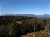
Dobrča is a 1634 m high mountain located between Begunje and Tržič. From the top, where the registration box with the stamp is located, there ope...
2 h 35 min |
 | Brezje pri Tržiču - Dobrča (via koča na Dobrči)
Dobrča is a 1634 m high mountain located between Begunje and Tržič. From the top, where the registration box with the stamp is located, there ope...
3 h |
| Brezje pri Tržiču - Dobrča (Po robu)
Dobrča is a 1634 m high mountain located between Begunje and Tržič. From the top, where the registration box with the stamp is located, there ope...
2 h 30 min |
 | Zadnja vas - Dobrča
Dobrča is a 1634 m high mountain located between Begunje and Tržič. From the top, where the registration box with the stamp is located, there ope...
3 h |
| Hudi Graben - Dobrča (via Koča na Dobrči)
Dobrča is a 1634 m high mountain located between Begunje and Tržič. From the top, where the registration box with the stamp is located, there ope...
3 h |
| Slatna - Dobrča
Dobrča is a 1634 m high mountain located between Begunje and Tržič. From the top, where the registration box with the stamp is located, there ope...
3 h |
 | Begunje (Preska) - Dobrča
Dobrča is a 1634 m high mountain located between Begunje and Tržič. From the top, where the registration box with the stamp is located, there ope...
3 h |
 | Brezje pri Tržiču - Dobrča (by road)
Dobrča is a 1634 m high mountain located between Begunje and Tržič. From the top, where the registration box with the stamp is located, there ope...
2 h 45 min |
 | Tuškov Grič - Blegoš (via Črni vrh)
Blegoš is a 1562 m high mountain located between Selška and Poljane Sora. From the grassy summit, on which there is a stamp and a registration bo...
2 h 45 min |
 | Petrovo Brdo - Možic (via Vrh Bače)
Možic is a 1602 m high peak located west of Soriška mountain pasture. It is at the highest point of the peak that there is an old military bunker...
2 h 30 min |
| Petrovo Brdo - Možic (via Lajnar)
Možic is a 1602 m high peak located west of Soriška mountain pasture. It is at the highest point of the peak that there is an old military bunker...
2 h 30 min |
 | Petrovo Brdo - Porezen
Porezen is a 1630 m high mountain located between Davča and Baška Grapa. From the top, where a large NOB monument stands, we have a beautiful vie...
2 h 30 min |
 | Tuškov Grič - Porezen (by road)
Porezen is a 1630 m high mountain located between Davča and Baška Grapa. From the top, where a large NOB monument stands, we have a beautiful vie...
3 h 5 min |
 | Raspet - Porezen (on ridge of Cimprovka)
Porezen is a 1630 m high mountain located between Davča and Baška Grapa. From the top, where a large NOB monument stands, we have a beautiful vie...
2 h 45 min |
 | Poče - Porezen (steep path)
Porezen is a 1630 m high mountain located between Davča and Baška Grapa. From the top, where a large NOB monument stands, we have a beautiful vie...
2 h 30 min |
| Poče - Porezen (gentle path)
Porezen is a 1630 m high mountain located between Davča and Baška Grapa. From the top, where a large NOB monument stands, we have a beautiful vie...
2 h 45 min |
 | Jesenica - Porezen
Porezen is a 1630 m high mountain located between Davča and Baška Grapa. From the top, where a large NOB monument stands, we have a beautiful vie...
2 h 55 min |
 | Jesenica - Porezen (via Dom na Poreznu)
Porezen is a 1630 m high mountain located between Davča and Baška Grapa. From the top, where a large NOB monument stands, we have a beautiful vie...
3 h |
| Preval Vrh Ravni - Porezen
Porezen is a 1630 m high mountain located between Davča and Baška Grapa. From the top, where a large NOB monument stands, we have a beautiful vie...
2 h 30 min |
| Preval Vrh Ravni - Porezen (via Dom na Poreznu)
Porezen is a 1630 m high mountain located between Davča and Baška Grapa. From the top, where a large NOB monument stands, we have a beautiful vie...
2 h 35 min |
 | Poče - Porezen (via Labinjske lehe)
Porezen is a 1630 m high mountain located between Davča and Baška Grapa. From the top, where a large NOB monument stands, we have a beautiful vie...
3 h 15 min |
| Poče - Porezen (winter way)
Porezen is a 1630 m high mountain located between Davča and Baška Grapa. From the top, where a large NOB monument stands, we have a beautiful vie...
3 h 25 min |
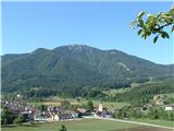
 | Grahovše - Bela peč (via Boršt)
The mountain, which is known mainly by climbers, is located north of Storžič on the slopes of Konjščice. From the top there is a beautiful view o...
2 h 30 min |
 | Grahovše - Bela peč (via rot)
The mountain, which is known mainly by climbers, is located north of Storžič on the slopes of Konjščice. From the top there is a beautiful view o...
2 h 30 min |
 | Grahovše - Bela peč (via Rekar)
The mountain, which is known mainly by climbers, is located north of Storžič on the slopes of Konjščice. From the top there is a beautiful view o...
2 h 30 min |
 | Mojstrana - Jerebikovec
The peak is slightly overgrown and is situated above Mojstrana and Radovna. From the top there is a beautiful view towards Karawanks and the moun...
2 h 20 min |
 | Preval - Koprivnik
Koprivnik is a 1393 m high mountain located between Blegoš and Mladi vrh. The view from the summit, which has a registration box and a stamp, is ...
3 h 15 min |
| Javorje - Koprivnik (via Brdo)
Koprivnik is a 1393 m high mountain located between Blegoš and Mladi vrh. The view from the summit, which has a registration box and a stamp, is ...
2 h 20 min |
 | Lipa - Vivodnik
At 1508 m, Vivodnik is the highest peak of the Menina mountain pasture, a plateau rising south of Gornji Grad. From the top, where there is a sma...
3 h 30 min |
 | Andrejev dom na Slemenu - Smrekovec
Smrekovec is a volcanic mountain on the eastern edge of the Smrekov Mountains. The extensive grassy summit, on which stands a pyramid with a regi...
3 h 30 min |
 | Javorje (Mala Črna) - Smrekovec (via Bukov stan)
Smrekovec is a volcanic mountain on the eastern edge of the Smrekov Mountains. The extensive grassy summit, on which stands a pyramid with a regi...
3 h 15 min |
| Javorje (Mala Črna) - Smrekovec (po cesti)
Smrekovec is a volcanic mountain on the eastern edge of the Smrekov Mountains. The extensive grassy summit, on which stands a pyramid with a regi...
3 h 15 min |
 | Valley of stream Žep - Veliki Travnik (Turnovka)
Veliki Travnik, or Turnovka as the locals call it, is located on the western edge of the Smrekov Mountains. From the top of the hill, where a woo...
2 h 45 min |
 | Bistra - Veliki Travnik (Turnovka)
Veliki Travnik, or Turnovka as the locals call it, is located on the western edge of the Smrekov Mountains. From the top of the hill, where a woo...
3 h 45 min |
 | Predmeja (Gorjanka) - Mali Golak
Mali Golak is the highest of the Golaks. It was named not because it was the smallest but because it had the smallest mountain pasture. On the ma...
2 h 25 min |
 | Gorenje pri Zrečah - Rogla
Rogla is the peak in the middle of the ski resort of the same name. The summit is woded with a small clearing on which stands a lookout tower. Th...
2 h 35 min |
 | Mašun - Mali Snežnik
Mali Snežnik is a peak on the west ridge of Snežnika. Vrh, which is covered with dwarf pines, has a fine view of the neighbouring Veliki Snežnik ...
3 h 35 min |
 | Poštarski dom pod Plešivcem - Uršlja gora (Plešivec) (via Kozarnica)
Uršlja gora or Plešivec is a lookout mountain between Slovenj Gradec and Črna na Koroškem. On the top or just below it stands the Church of St Ur...
2 h 30 min |
| Poštarski dom pod Plešivcem - Uršlja gora (Plešivec) (via Kal)
Uršlja gora or Plešivec is a lookout mountain between Slovenj Gradec and Črna na Koroškem. On the top or just below it stands the Church of St Ur...
2 h 45 min |
 | Ciganija - Uršlja gora (Plešivec) (winter way)
Uršlja gora or Plešivec is a lookout mountain between Slovenj Gradec and Črna na Koroškem. On the top or just below it stands the Church of St Ur...
2 h 30 min |
 | Ivarčko jezero - Uršlja gora (Plešivec) (Železarska pot)
Uršlja gora or Plešivec is a lookout mountain between Slovenj Gradec and Črna na Koroškem. On the top or just below it stands the Church of St Ur...
2 h 45 min |
 | Ivarčko jezero - Uršlja gora (Plešivec) (via Kozji hrbet)
Uršlja gora or Plešivec is a lookout mountain between Slovenj Gradec and Črna na Koroškem. On the top or just below it stands the Church of St Ur...
3 h |
 | Andrejev dom na Slemenu - Uršlja gora (Plešivec)
Uršlja gora or Plešivec is a lookout mountain between Slovenj Gradec and Črna na Koroškem. On the top or just below it stands the Church of St Ur...
2 h 45 min |
 | Sveti Danijel (Zgornji Razbor) - Uršlja gora (Plešivec)
Uršlja gora or Plešivec is a lookout mountain between Slovenj Gradec and Črna na Koroškem. On the top or just below it stands the Church of St Ur...
3 h 15 min |
 | Petrovo Brdo - Krevl
Krevl is a 1515 m high peak located to the south of the Kobla ski area, more precisely between Koble Peak and Kravje Črna Gora. From the summit, ...
2 h 30 min |
 | Ravne - Krevl
Krevl is a 1515 m high peak located to the south of the Kobla ski area, more precisely between Koble Peak and Kravje Črna Gora. From the summit, ...
2 h 20 min |
 | Avsa - Monte Mataiur/Matajur
Monte Mataiur is a scenic mountain located on the border between Slovenia and Itali. From the top, you have a beautiful view of the Kobarid or Br...
2 h 30 min |
 | Masseris - Monte Mataiur/Matajur
Monte Mataiur is a scenic mountain located on the border between Slovenia and Itali. From the top, you have a beautiful view of the Kobarid or Br...
2 h 30 min |
 | Avsa - Monte Mataiur/Matajur (old path)
Monte Mataiur is a scenic mountain located on the border between Slovenia and Itali. From the top, you have a beautiful view of the Kobarid or Br...
2 h 30 min |
| Livek - Monte Mataiur/Matajur
Monte Mataiur is a scenic mountain located on the border between Slovenia and Itali. From the top, you have a beautiful view of the Kobarid or Br...
3 h |
 | Slovenji Plajberk / Windisch Bleiberg - Singerberg / Žingarica (via saddle Albink / Halbingsattel)
Singerberg is a peak located on the Austrian side of Karawanks above the village of Slovenji Plajberk / Windisch Bleiberg. The summit, which is p...
2 h 20 min |
| Plajberški graben / Bleiberger Graben - Singerberg / Žingarica
Singerberg is a peak located on the Austrian side of Karawanks above the village of Slovenji Plajberk / Windisch Bleiberg. The summit, which is p...
2 h 20 min |
 | Podmeja - Črni vrh (Čemšeniška planina)
Črni vrh is the highest peak of Čemšeniška mountain pasture and with a height of 1204 m it is the second highest peak in the Posavje - Zasavje hi...
3 h 30 min |
| Dom pod Reško planino - Črni vrh (Čemšeniška planina)
Črni vrh is the highest peak of Čemšeniška mountain pasture and with a height of 1204 m it is the second highest peak in the Posavje - Zasavje hi...
3 h |
 | Črni vrh - Javornik above Črni vrh (via Šajsna Ravan)
Javornik is a forested peak located southeast of Črnji Vrho. In 1972, a lookout tower was erected on the summit, which reaches above the treetops...
2 h 30 min |
 | Jeršiče - Veliki Javornik (Javorniki)
Veliki Javornik is a 1,268-metre-high peak in the forested hills called the Javorniki. The vast forests of the Javorniki stretch from Postojna to...
2 h 20 min |
 | Šmartno na Pohorju - Žigartov vrh (via Bojtina)
At 1346m, Žigartov vrh is the highest peak in the eastern part of Pohorje. An "observation" tower used to stand on the summit, but was erected on...
3 h 15 min |
 | Platak - Veliki Risnjak
At 1528m, Veliki Risnjak is the highest peak in the Risnjak National Park. From the summit, which has a registration box and a stamp, there is a ...
3 h 30 min |
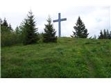
 | Zadnja vas - Šentanski vrh
Šentanski vrh, located in the Dobrča mountain range, only 5 minutes away from the main peak, offers a beautiful view of the central Karawanks, th...
3 h 5 min |
| Hudi Graben - Šentanski vrh (via Koča na Dobrči)
Šentanski vrh, located in the Dobrča mountain range, only 5 minutes away from the main peak, offers a beautiful view of the central Karawanks, th...
3 h 5 min |
| Slatna - Šentanski vrh
Šentanski vrh, located in the Dobrča mountain range, only 5 minutes away from the main peak, offers a beautiful view of the central Karawanks, th...
3 h 5 min |
 | Begunje (Preska) - Šentanski vrh
Šentanski vrh, located in the Dobrča mountain range, only 5 minutes away from the main peak, offers a beautiful view of the central Karawanks, th...
3 h 5 min |
| Brezje pri Tržiču - Šentanski vrh (by road)
Šentanski vrh, located in the Dobrča mountain range, only 5 minutes away from the main peak, offers a beautiful view of the central Karawanks, th...
2 h 50 min |
 | Brezje pri Tržiču - Šentanski vrh (Po robu)
Šentanski vrh, located in the Dobrča mountain range, only 5 minutes away from the main peak, offers a beautiful view of the central Karawanks, th...
2 h 35 min |
| Brezje pri Tržiču - Šentanski vrh (on path Po robu and via Lešanska planina)
Šentanski vrh, located in the Dobrča mountain range, only 5 minutes away from the main peak, offers a beautiful view of the central Karawanks, th...
2 h 40 min |
 | Strane - Suhi vrh (Nanos) (gentle path)
At 1313m, Suhi vrh is the highest peak of the karst plateau of Nanos. From the summit, which has a registration box and a stamp (the stamp is cur...
2 h 30 min |
 | Furlanovo zavetišče pri Abramu - Suhi vrh (Nanos) (steep path)
At 1313m, Suhi vrh is the highest peak of the karst plateau of Nanos. From the summit, which has a registration box and a stamp (the stamp is cur...
3 h 40 min |
| Furlanovo zavetišče pri Abramu - Suhi vrh (Nanos) (gentle path)
At 1313m, Suhi vrh is the highest peak of the karst plateau of Nanos. From the summit, which has a registration box and a stamp (the stamp is cur...
3 h 55 min |
| Hunting cottage Vojkovo - Suhi vrh (Nanos) (gentle path)
At 1313m, Suhi vrh is the highest peak of the karst plateau of Nanos. From the summit, which has a registration box and a stamp (the stamp is cur...
3 h 25 min |
| Hunting cottage Vojkovo - Suhi vrh (Nanos) (steep path)
At 1313m, Suhi vrh is the highest peak of the karst plateau of Nanos. From the summit, which has a registration box and a stamp (the stamp is cur...
3 h 10 min |
 | Forestry cottage Rovtarica - Gladki vrh (Ratitovec)
Gladki vrh is the most visited peak in the Ratitovec mountain range with an altitude of 1667 m. The uncultivated summit, on which the viewing pla...
3 h 35 min |
 | Bitenjska planina - Gladki vrh (Ratitovec)
Gladki vrh is the most visited peak in the Ratitovec mountain range with an altitude of 1667 m. The uncultivated summit, on which the viewing pla...
2 h 25 min |
 | Forestry cottage Rovtarica - Altemaver (Ratitovec)
Altemaver is the highest peak of Ratitovec at 1678 m. The grassy peak offers a beautiful view of Julian Alps, Jelovica, Karawanks, Kamnik Savinja...
3 h 40 min |
 | Bitenjska planina - Altemaver (Ratitovec)
Altemaver is the highest peak of Ratitovec at 1678 m. The grassy peak offers a beautiful view of Julian Alps, Jelovica, Karawanks, Kamnik Savinja...
2 h 30 min |
 | Rotek - Altemaver (Ratitovec)
Altemaver is the highest peak of Ratitovec at 1678 m. The grassy peak offers a beautiful view of Julian Alps, Jelovica, Karawanks, Kamnik Savinja...
2 h 30 min |
 | Montemaggiore - Punta di Montemaggiore
Punta di Montemaggiore or Italian. Punta di Montemaggiore is a 1613 m high mountain located above the source of the River Nadija, on the Italian ...
3 h |
 | Zrmanja Railway Station - Poštak
Poštak (also "Kečina kosa") is a picturesque mountain at the crossroads of Lika and Dalmatia. It belongs to the Lika Plješivica mountain range as...
2 h 30 min |
 | Rotek - Kremant (Ratitovec)
Kremant is a 1654 m high peak located in the western part of Ratitovec. From the top, where a stamp is attached to a metal pole, we have a beauti...
2 h 30 min |
 | Poče - Medrce (winter way)
Medrce is a 1410 m high peak located between Porezno and Hum. From the top, where the old bunker is located, we have a beautiful view of Kojca, P...
2 h 40 min |
| Poče - Medrce (via Labinjske lehe)
Medrce is a 1410 m high peak located between Porezno and Hum. From the top, where the old bunker is located, we have a beautiful view of Kojca, P...
2 h 30 min |
 | Poče - Kopa (Cimprovka) (winter way)
Kopa is a 1360 m high peak or viewing pier from which we can enjoy a beautiful view of Cerkno, the hills surrounding the above-mentioned place, R...
2 h 25 min |
 | Žabnice / Camporosso in Valcanale - Florjanka / Monte Florianca
Florjanka is a 1,653-metre-high mountain on the Italian side of the Julian Alps. At the top or just below it, there is a reservoir for snowmaking...
2 h 30 min |
 | Poden / Bodental - Kosmatica / Kosmatitza
Kosmatica is a 1659 m high peak located entirely on the Austrian side of Karawanks, north of Vrtača. The summit, which is partly covered by fores...
2 h 40 min |
 | Veliko Tinje - Veliki vrh (on Pohorje)
Veliki vrh is a 1344-metre-high peak located above the RTC Jakec - Trije kralji ski resort. The highest point of the peak is located in the fores...
2 h 30 min |
| Šmartno na Pohorju - Veliki vrh (on Pohorje)
Veliki vrh is a 1344-metre-high peak located above the RTC Jakec - Trije kralji ski resort. The highest point of the peak is located in the fores...
2 h 45 min |
 | Mariensee - Steinerne Stiege (red trail)
Steinerne Stiege is a less prominent peak in the Wechsell mountain range....
2 h 25 min |
 | Mönichkirchen - Niederwechsel (via Steinerne Stiege)
Niederwechsel is a scenic peak in the Wechsel massif. The view from the top is spectacular, reaching far in all directions, as there are no highe...
2 h 25 min |
| Mariensee - Niederwechsel (red trail)
Niederwechsel is a scenic peak in the Wechsel massif. The view from the top is spectacular, reaching far in all directions, as there are no highe...
3 h 15 min |
 | Rettenegg - Grazer Stuhleck (past Roseggerhaus)
...
2 h 40 min |
| Rettenegg - Grazer Stuhleck (via Schwarzriegel)
...
2 h 40 min |
 | Rettenegg - Geiereck (past Roseggerhaus)
...
2 h 25 min |
| Rettenegg - Geiereck (via Schwarzriegel)
...
2 h 55 min |
 | Rettenegg - Peter-Bergner-Warte (Pretul) (via Schwarzriegel)
...
3 h 5 min |
 | Rettenegg - Amundsenhöhe (past Roseggerhaus)
...
2 h 25 min |
| Rettenegg - Amundsenhöhe (via Schwarzriegel)
...
3 h 20 min |
 | Sankt Ilgen (Der Bodenbauer) - Buchbergkogel
...
2 h 30 min |
 | Zelovo - Svilaja (past Umac)
...
3 h |
 | Seetal - Voisthalerhütte
...
2 h 50 min |
 | Unternberg - Arabichl (via Kampstein)
...
3 h 45 min |
| St. Corona am Wechsel - Arabichl
...
3 h 15 min |
 | Gasen - Plankogel (by learning trail)
...
2 h 35 min |
 | Laufnitzgraben - Bei den drei Pfarren
...
2 h 30 min |
 | Niklasdorfgraben (parking lot Mugel) - Rosseck (via Mugel)
...
2 h 30 min |
 | Mazinski preval - Kremen
...
2 h 30 min |
 | Alpl (Waldschulle Alpl) - Steinriegel
...
3 h 10 min |