Žabnice / Camporosso in Valcanale - Florjanka / Monte Florianca
Starting point: Žabnice / Camporosso in Valcanale (858 m)
| Lat/Lon: | 46,5044°N 13,5404°E |
| |
Time of walking: 2 h 30 min
Difficulty: easy marked way
Altitude difference: 795 m
Altitude difference po putu: 825 m
Map: Julijske Alpe - zahodni del 1:50.000
Recommended equipment (summer):
Recommended equipment (winter): ice axe, crampons
Views: 1.900
 | 1 person likes this post |
Access to the starting point:
Via Border crossing Rateče or Border crossing Predel, drive to Trbiz / Tarvisio, then continue towards Udine and the settlements of Frogs / Camporosso and Valcanale. When Trbiz ends, just after the Eurospar store (the store is on the right hand side of the road), before the main roundabout, turn left onto Via Lussari. Drive along the street for a few 100 metres, then come to a small crossroads, and continue straight on from the crossroads and park in the parking lot on the right-hand side of the road after the crossroads. Park in the lower part of the parking lot, the upper part is marked no parking with a no parking sign.
Path description:
From the starting point, continue along the asphalt road, which is closed to public traffic and leads past a few houses. Above the hamlet, the path leads us past an information board, and then the asphalt ends. We continue on the macadam road, which leads us through the Višarski graben, through which the Rio Lussari stream flows. Higher up, the road turns into a wide cart track, with the Stations of the Cross appearing alongside.
We continue for some time on the cart track, which only occasionally opens up some views in the direction of Carnic Alps, where we can see Ojstrnik. Higher up, a marked footpath branches off to the right from cart track to Kamniti lovec and Svete Višarje, and we continue along cart track a little further on to Višarska planina, from where we get a nice view of the Beraški Križ.
From mountain pasture, where you also reach the ski slope, continue to the left (the stone hunter and Svete Višarje on the right) and follow the service road which continues along and by the ski slope. A little further on, at a small junction, continue along the upper left road, which drops off at the covered conveyor belt. A few minutes of climbing follow, and then you reach the top of Florjanka, from where you have a nice view.
Description and pictures refer to 2017 (July).

Pictures:
 1
1 2
2 3
3 4
4 5
5 6
6 7
7 8
8 9
9 10
10 11
11 12
12 13
13 14
14 15
15 16
16 17
17 18
18 19
19 20
20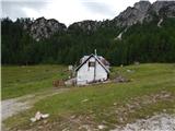 21
21 22
22 23
23 24
24 25
25 26
26 27
27 28
28 29
29 30
30 31
31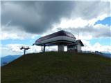 32
32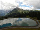 33
33 34
34
Discussion about the trail Žabnice / Camporosso in Valcanale - Florjanka / Monte Florianca