 | Kostanjevica na Krasu - Fajti hrib
Fajti, according to some records also Fajti hrib, is a 433 m high peak located in the ridge of the Black Hills. The summit, which is known mainly...
1 h 10 min |
 | Ljubljana (Štepanja vas) - Črni hrib (Golovec)
Črni hrib is a 440 m high hill located in the central part of Golovec. The so-called Path of Remembrance and Comradeship leads over the top, wher...
50 min |
 | Ljubljana (Botanični vrt) - Mazovnik (Golovec)
At 450 m, Mazovnik is the highest peak of Golovec, a hill located in the south-eastern part of Ljubljana. Golovec was unforested until the end of...
1 h 5 min |
 | Ljubljana (Štepanja vas) - Mazovnik (Golovec)
At 450 m, Mazovnik is the highest peak of Golovec, a hill located in the south-eastern part of Ljubljana. Golovec was unforested until the end of...
1 h |
 | Podgrad - Lazarjev vrh
Lazarjev vrh is a 452-metre-high peak above the confluence of the Sava, Ljubljanica and Kamniška Bistrica rivers, east of Podgrad. The summit, wh...
50 min |
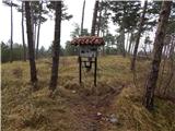
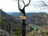
 | Kostanjevica na Krasu - Veliki vrh (Črni hribi)
Veliki vrh is a 463 m high peak located in the ridge of the Black Hills. The summit, where the registration box is located, has no view due to th...
1 h 15 min |
 | Dragomer (OŠ Log-Dragomer) - Strmca (čez Strmec)
Strmca is a lesser-known and forested hill located between Brezje pri Dobrovi and Log pri Brezovici. There is no view from the top due to the for...
1 h 10 min |
 | Stoperce - Škrbatnica
...
50 min |
 | Ruše - Kluže
...
45 min |
 | Sveti Mihovil (nad Komižo) - Mali Hum
...
50 min |
 | Gojače - Školj Svetega Pavla above Vrtovin (via water tower)
The St Paul's Collegium is located on a lookout above the village of Vrtovin, west of Ajdovščina. From the church, near which the registration bo...
1 h |
 | Tremerje - Kamčič (on the ridge of Mali Slomnik)
Kamčič is a vegetated peak in Posavsko hribovje, located north of Šmohor, between Kotečnik on the left and Veliki Slomnik on the right. It can be...
1 h 15 min |
 | Liboje - Kamčič (via organic farm Kralj - northern approach)
Kamčič is a vegetated peak in Posavsko hribovje, located north of Šmohor, between Kotečnik on the left and Veliki Slomnik on the right. It can be...
45 min |
 | Podgrad - Debenji vrh
Debenji vrh, also Debni or Deben vrh, is the highest peak of Kašeljski Hill, a small mountain range located between the valley of Besnica and the...
1 h |
| Podgrad - Debenji vrh (via old castle Osterberg)
Debenji vrh, also Debni or Deben vrh, is the highest peak of Kašeljski Hill, a small mountain range located between the valley of Besnica and the...
50 min |
 | Vrzdenec - Gradišče nad Žažarjem (via Žažar)
Gradišče nad Žažarjem is a viewpoint with a large wooden cross. From the top, which also has a registration box with a stamp, you have a beautifu...
1 h |
| Vrzdenec - Gradišče nad Žažarjem (via Plesa)
Gradišče nad Žažarjem is a viewpoint with a large wooden cross. From the top, which also has a registration box with a stamp, you have a beautifu...
45 min |
 | Želimlje - Castle Stari grad above Želimlje
Castle Stari grad above Želimlje is a forested peak located between Želimlje and Rogatec above Želimlje....
50 min |
 | Podgrad - Španov vrh (Besnica)
Španov vrh is a 559-metre-high peak above the valley of the Besnica stream between Podgrad and Besnica. Just below the summit is the Borovnice hi...
50 min |
 | Bad Gleichenberg (Eichgraben Weg) - Bschaidkogel (via Mühlsteinbruch)
...
50 min |
 | Povodje - Veliki vrh (Rašica)
Veliki vrh is a 568 m high hill located to the west of Stanet Kosec Vrch. Just a few metres below the summit, which is covered with forest, is a ...
45 min |
 | Podgrad - Grmadnik
Grmadnik is a 569-metre-high peak above the valley of the Besnica stream between Podgrad and Besnica. The Borovnice hiking trail passes just belo...
55 min |
 | Celje (hanging bridge) - Hom above Celje
Hom is a forested peak located north of Košnica near Celje. There is a small bench on top of the summit next to the registration box....
1 h |
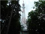
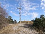 | Sežana - Zidovnik (Sedovnik) (by road)
Zidovnik is a 575m high peak located west of Sežana. The view from the summit, where some transmitters are located, is limited due to the forest ...
1 h |
 | Kamnik - Castle Stari grad Kamnik (by road)
Castle Stari grad Kamnik, sometimes called Zgornji grad (Oberstain), is located on a scenic peak to the east of Kamnik called Krniška gora (Krniš...
1 h |
 | Ruše - Lorbekov vrh
Lorbekov vrh is a 578-metre-high peak located south-west of Ruše. The peak is located in a forest, but the meadow just below the peak offers a be...
45 min |
 | Strmica - Toško Čelo (via Brezarjevo brezno)
Toško Čelo is a 590 m high hill above the village of the same name. From the top, or slightly lower down, you have a beautiful view of part of Lj...
45 min |
 | Šujica (Na Gmajni) - Toško Čelo (along the stream Ostrožnik)
Toško Čelo is a 590 m high hill above the village of the same name. From the top, or slightly lower down, you have a beautiful view of part of Lj...
55 min |
 | Šujica (Na Gmajni) - Toško Čelo
Toško Čelo is a 590 m high hill above the village of the same name. From the top, or slightly lower down, you have a beautiful view of part of Lj...
50 min |
 | Brzika - Joški vrh
Joški vrh is a 595-metre-high peak located on the northern side of Donacca Mountain. A short unmarked trail leads to the summit, which branches o...
1 h 15 min |
| Sveti Jurij - Joški vrh
Joški vrh is a 595-metre-high peak located on the northern side of Donacca Mountain. A short unmarked trail leads to the summit, which branches o...
1 h 5 min |
 | Dobrova - Vrhe above Dobrova
Vrhe is a lesser-known but important peak in the extreme SE part of the Polhograje hills. It is reached by several unmarked tracks and trails lea...
50 min |
 | Hruševo - Vrhe above Dobrova
Vrhe is a lesser-known but important peak in the extreme SE part of the Polhograje hills. It is reached by several unmarked tracks and trails lea...
1 h |
 | Ožbalt (jez na potoku Črmenica) - Turška peč (po kolovozu)
...
1 h |
 | Podlipoglav - Pugled (past the guard post)
Pugled is a 615m high peak located between Podlipoglav and Veliki Lipoglav. The view from the top of the large NOB monument is limited due to the...
50 min |
 | Podlipoglav - Pugled (on the western ridge)
Pugled is a 615m high peak located between Podlipoglav and Veliki Lipoglav. The view from the top of the large NOB monument is limited due to the...
50 min |
 | Ruše - Globokarjev vrh
...
1 h 15 min |
 | Sora - Breznik (Boben)
Breznik, aka Boben, is a 643-metre-high peak located above the right bank of the Ločnica River, specifically above the Sora, Rakovnik, Goričane a...
1 h 5 min |
| Rakovnik - Breznik (Boben)
Breznik, aka Boben, is a 643-metre-high peak located above the right bank of the Ločnica River, specifically above the Sora, Rakovnik, Goričane a...
55 min |