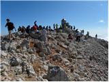
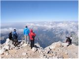
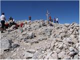
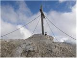
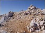
 | Aljažev dom v Vratih - Triglav (Tominšek route)
Triglav is a 2,864 m high mountain located in the heart of the Julian Alps. It is the highest mountain in Slovenia and also the highest peak in t...
6 h 10 min |
| Aljažev dom v Vratih - Triglav (via Prag)
Triglav is a 2,864 m high mountain located in the heart of the Julian Alps. It is the highest mountain in Slovenia and also the highest peak in t...
6 h 20 min |
 | Aljažev dom v Vratih - Triglav (via Plemenice)
Triglav is a 2,864 m high mountain located in the heart of the Julian Alps. It is the highest mountain in Slovenia and also the highest peak in t...
6 h 30 min |
| The Kot Valley - Triglav
Triglav is a 2,864 m high mountain located in the heart of the Julian Alps. It is the highest mountain in Slovenia and also the highest peak in t...
6 h 25 min |
| The Krma Valley - Triglav (via Kredarica)
Triglav is a 2,864 m high mountain located in the heart of the Julian Alps. It is the highest mountain in Slovenia and also the highest peak in t...
6 h 15 min |
| The Krma Valley - Triglav (via Planika and Mali Triglav)
Triglav is a 2,864 m high mountain located in the heart of the Julian Alps. It is the highest mountain in Slovenia and also the highest peak in t...
6 h |
 | The Krma Valley - Triglav (via Planika and Triglavska škrbina)
Triglav is a 2,864 m high mountain located in the heart of the Julian Alps. It is the highest mountain in Slovenia and also the highest peak in t...
5 h 55 min |
| end of road on Pokljuka - Triglav (via Kredarica)
Triglav is a 2,864 m high mountain located in the heart of the Julian Alps. It is the highest mountain in Slovenia and also the highest peak in t...
6 h 15 min |
| end of road on Pokljuka - Triglav (via Planika and Mali Triglav)
Triglav is a 2,864 m high mountain located in the heart of the Julian Alps. It is the highest mountain in Slovenia and also the highest peak in t...
6 h |
| Uskovnica (Razpotje) - Triglav (via Planika and Mali Triglav)
Triglav is a 2,864 m high mountain located in the heart of the Julian Alps. It is the highest mountain in Slovenia and also the highest peak in t...
6 h 30 min |
 | Planina Blato - Triglav (Za Kopico)
Triglav is a 2,864 m high mountain located in the heart of the Julian Alps. It is the highest mountain in Slovenia and also the highest peak in t...
8 h |
| Uskovnica (Razpotje) - Triglav (via Triglavska škrbina)
Triglav is a 2,864 m high mountain located in the heart of the Julian Alps. It is the highest mountain in Slovenia and also the highest peak in t...
6 h 25 min |
| end of road on Pokljuka - Triglav (via Planika and Triglavska škrbina)
Triglav is a 2,864 m high mountain located in the heart of the Julian Alps. It is the highest mountain in Slovenia and also the highest peak in t...
5 h 55 min |
| Rudno polje - Triglav (via Kredarica)
Triglav is a 2,864 m high mountain located in the heart of the Julian Alps. It is the highest mountain in Slovenia and also the highest peak in t...
6 h 40 min |
| Uskovnica (Lom) - Triglav (via Triglavska škrbina)
Triglav is a 2,864 m high mountain located in the heart of the Julian Alps. It is the highest mountain in Slovenia and also the highest peak in t...
6 h 30 min |
| Rudno polje - Triglav (via Dom Planika and Mali Triglav)
Triglav is a 2,864 m high mountain located in the heart of the Julian Alps. It is the highest mountain in Slovenia and also the highest peak in t...
6 h 25 min |
| Rudno polje - Triglav (mimo Doma Planika in čez Triglavsko škrbino)
Triglav is a 2,864 m high mountain located in the heart of the Julian Alps. It is the highest mountain in Slovenia and also the highest peak in t...
6 h 20 min |
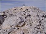
 | Aljažev dom v Vratih - Mali Triglav (via Prag)
Mali Triglav is an inconspicuous peak on the main ridge of Triglav. Despite its considerable height, few hikers choose it as an independent desti...
5 h 45 min |
| The Kot Valley - Mali Triglav
Mali Triglav is an inconspicuous peak on the main ridge of Triglav. Despite its considerable height, few hikers choose it as an independent desti...
5 h 50 min |
| Aljažev dom v Vratih - Mali Triglav (Tominšek route)
Mali Triglav is an inconspicuous peak on the main ridge of Triglav. Despite its considerable height, few hikers choose it as an independent desti...
5 h 35 min |
| The Krma Valley - Mali Triglav (via Kredarica)
Mali Triglav is an inconspicuous peak on the main ridge of Triglav. Despite its considerable height, few hikers choose it as an independent desti...
5 h 40 min |
| Rudno polje - Mali Triglav (via Kredarica)
Mali Triglav is an inconspicuous peak on the main ridge of Triglav. Despite its considerable height, few hikers choose it as an independent desti...
6 h 5 min |
| Uskovnica (Razpotje) - Mali Triglav (via Planika and Mali Triglav)
Mali Triglav is an inconspicuous peak on the main ridge of Triglav. Despite its considerable height, few hikers choose it as an independent desti...
5 h 55 min |
 | Loška Koritnica - Mangart
Mangart (also Mangrt; both spellings are grammatically correct) is a mountain that attracts a very large number of visitors in summer. The approa...
7 h |
 | Zadnja Trenta (Flori) - Jalovec (via Jalovška škrbina)
At 2,645 m, Jalovec is the sixth highest mountain in Slovenia. The summit, which drops steeply towards three alpine valleys (Loška Koritnica, Tam...
5 h 40 min |
| Zadnja Trenta (Flori) - Jalovec (via Zavetišče pod Špičkom)
At 2,645 m, Jalovec is the sixth highest mountain in Slovenia. The summit, which drops steeply towards three alpine valleys (Loška Koritnica, Tam...
5 h 45 min |
 | NC Planica - Jalovec (mimo bivaka in čez Kotovo sedlo)
At 2,645 m, Jalovec is the sixth highest mountain in Slovenia. The summit, which drops steeply towards three alpine valleys (Loška Koritnica, Tam...
6 h 10 min |
| NC Planica - Jalovec (via Jalovška škrbina)
At 2,645 m, Jalovec is the sixth highest mountain in Slovenia. The summit, which drops steeply towards three alpine valleys (Loška Koritnica, Tam...
6 h 30 min |
| Loška Koritnica - Jalovec (via Zavetišče pod Špičkom)
At 2,645 m, Jalovec is the sixth highest mountain in Slovenia. The summit, which drops steeply towards three alpine valleys (Loška Koritnica, Tam...
7 h 30 min |
| NC Planica - Jalovec (on scree and over Kotovo sedlo)
At 2,645 m, Jalovec is the sixth highest mountain in Slovenia. The summit, which drops steeply towards three alpine valleys (Loška Koritnica, Tam...
6 h 10 min |
 | Aljažev dom v Vratih - Razor (via Sovatna)
The summit lies above the alpine valley of Mlinarica. Though not spacious, it offers a very beautiful view. All the peaks above Kriški podi are c...
6 h 30 min |
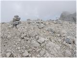
 | Aljažev dom v Vratih - Dolkova špica (eastern way)
Dolkova špica is a 2,591 m high mountain situated between Stenar and Škrlatica. From the summit, where the summit register box is located, a beau...
5 h 30 min |
| Pišnica - Dolkova špica (via Kriška stena)
Dolkova špica is a 2,591 m high mountain situated between Stenar and Škrlatica. From the summit, where the summit register box is located, a beau...
6 h 35 min |
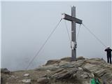
 | Gozdec - Visoki Kanin (via Zadnji dol)
Visoki Kanin is the highest peak of the Kanin Mountains. From the summit on which the cross stands, you have a beautiful view of the western Juli...
6 h |
 | Sella Nevea - Visoki Kanin (Via ferrata Rosalba Grasselli)
Visoki Kanin is the highest peak of the Kanin Mountains. From the summit on which the cross stands, you have a beautiful view of the western Juli...
6 h 15 min |
 | Gozdec - Visoki Kanin (via Dom Petra skalarja na Kaninu)
Visoki Kanin is the highest peak of the Kanin Mountains. From the summit on which the cross stands, you have a beautiful view of the western Juli...
6 h 40 min |
 | Gozdec - Visoki Kanin (Alta Via Resiana)
Visoki Kanin is the highest peak of the Kanin Mountains. From the summit on which the cross stands, you have a beautiful view of the western Juli...
7 h |
 | Gozdec - Mali Kanin (Alta Via Resiana)
Mali Kanin is the neighbouring mountain of the better-known Visoki Kanin. The summit has a beautiful view of the Kanin mountain range and the pea...
6 h 40 min |
 | V Koncu - Grintovec (via Kokrsko and Mlinarsko sedlo)
Grintovec is the highest peak in the Kamnik and Savinja Alps. It is located above the valley of Kamniška Bistrica, Suhi dol and above the valley ...
5 h 30 min |
| Suhadolnik - Grintovec (via Kokrsko and Mlinarsko sedlo)
Grintovec is the highest peak in the Kamnik and Savinja Alps. It is located above the valley of Kamniška Bistrica, Suhi dol and above the valley ...
5 h 45 min |
| Ravenska Kočna - Grintovec (via Štularjeva planina and on path Frischaufova pot)
Grintovec is the highest peak in the Kamnik and Savinja Alps. It is located above the valley of Kamniška Bistrica, Suhi dol and above the valley ...
5 h 30 min |
 | Ravenska Kočna - Grintovec (via Štularjeva planina and on path Kremžarjeva pot)
Grintovec is the highest peak in the Kamnik and Savinja Alps. It is located above the valley of Kamniška Bistrica, Suhi dol and above the valley ...
5 h 30 min |
 | Ravenska Kočna - Jezerska Kočna (Frischauf way)
Jezerska Kočna is located west of Grintovec. From the summit there is a very beautiful view towards Grintovec. The Karawanks and the Gorenjska pl...
6 h 30 min |
 | Suhadolnik - Jezerska Kočna (via Kokrsko sedlo and Dolci)
Jezerska Kočna is located west of Grintovec. From the summit there is a very beautiful view towards Grintovec. The Karawanks and the Gorenjska pl...
6 h 15 min |
| V Koncu - Jezerska Kočna (via Dolci)
Jezerska Kočna is located west of Grintovec. From the summit there is a very beautiful view towards Grintovec. The Karawanks and the Gorenjska pl...
6 h |
 | V Koncu - Jezerska Kočna (via Kokrska Kočna)
Jezerska Kočna is located west of Grintovec. From the summit there is a very beautiful view towards Grintovec. The Karawanks and the Gorenjska pl...
6 h |
| Suhadolnik - Jezerska Kočna (via Kokrsko sedlo and Kokrska Kočna)
Jezerska Kočna is located west of Grintovec. From the summit there is a very beautiful view towards Grintovec. The Karawanks and the Gorenjska pl...
6 h 15 min |
| Ravenska Kočna - Jezerska Kočna (umik Žrela and on Frischaufova pot)
Jezerska Kočna is located west of Grintovec. From the summit there is a very beautiful view towards Grintovec. The Karawanks and the Gorenjska pl...
6 h 35 min |
| Ravenska Kočna - Jezerska Kočna (via Štularjeva planina and on path Frischaufova pot)
Jezerska Kočna is located west of Grintovec. From the summit there is a very beautiful view towards Grintovec. The Karawanks and the Gorenjska pl...
6 h 30 min |
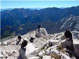
 | The Kot Valley - Rjavina (ridge way)
Rjavina is located between two Alpine valleys. The two valleys are Kot and Krma. From the summit, which has a registration book, there is a very ...
6 h 10 min |
| Aljažev dom v Vratih - Rjavina (via Prag)
Rjavina is located between two Alpine valleys. The two valleys are Kot and Krma. From the summit, which has a registration book, there is a very ...
6 h 30 min |
| Aljažev dom v Vratih - Rjavina (Tominšek route)
Rjavina is located between two Alpine valleys. The two valleys are Kot and Krma. From the summit, which has a registration book, there is a very ...
6 h 25 min |
| Dolina Krma - Rjavina (ridge path)
Rjavina is located between two Alpine valleys. The two valleys are Kot and Krma. From the summit, which has a registration book, there is a very ...
6 h 45 min |
 | Ravenska Kočna - Skuta (past the cableway and over Dolgi hrbet)
Skuta is a 2532 m high mountain located in the heart of the Kamnik-Savinja Alps. From the top, where there is a registration box and a stamp, we ...
5 h 45 min |
| Ravenska Kočna - Skuta (umik Žrela and over Dolgi hrbet)
Skuta is a 2532 m high mountain located in the heart of the Kamnik-Savinja Alps. From the top, where there is a registration box and a stamp, we ...
5 h 50 min |
| Ravenska Kočna - Skuta (via Štularjeva planina and Dolgi hrbet)
Skuta is a 2532 m high mountain located in the heart of the Kamnik-Savinja Alps. From the top, where there is a registration box and a stamp, we ...
5 h 45 min |
 | Ravenska Kočna - Kokrska Kočna (past the cableway and on Kremžarjeva pot)
Kokrska Kočna is a scenic and vast mountain between Jezersko and Suhadolnik. From the top, which has a registration box, there is a very nice vie...
5 h 30 min |
 | Suhadolnik - Kokrska Kočna (via Kokrsko sedlo)
Kokrska Kočna is a scenic and vast mountain between Jezersko and Suhadolnik. From the top, which has a registration box, there is a very nice vie...
5 h 45 min |
| V Koncu - Kokrska Kočna
Kokrska Kočna is a scenic and vast mountain between Jezersko and Suhadolnik. From the top, which has a registration box, there is a very nice vie...
5 h 30 min |
| Ravenska Kočna - Kokrska Kočna (umik Žrela and on Kremžarjeva pot)
Kokrska Kočna is a scenic and vast mountain between Jezersko and Suhadolnik. From the top, which has a registration box, there is a very nice vie...
5 h 35 min |
| Ravenska Kočna - Kokrska Kočna (via Štularjeva planina and on path Kremžarjeva pot)
Kokrska Kočna is a scenic and vast mountain between Jezersko and Suhadolnik. From the top, which has a registration box, there is a very nice vie...
5 h 30 min |
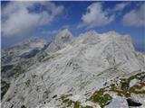
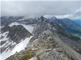
 | Pišnica - Stenar (via Križ)
Stenar is a 2501 m high peak rising steeply above the Vrata valley. From the spacious summit, where there is a registration box and a stamp, we h...
6 h 55 min |
 | Pišnica - Špik (via Koča v Krnici)
Špik is a 2472 m high mountain located in the heart of the Martuljek Group. From the top, which is clearly visible from the road leading through ...
5 h 30 min |
 | V Koncu - Brana (via Turska gora)
Brana is a mountain above Kamniško sedlo. From the spacious summit, which has a registration box and a small cross, there is a very beautiful vie...
5 h 45 min |
 | Aljažev dom v Vratih - Cmir (via Prag)
The mountain is located between two Alpine valleys between Vrata and the lesser-known Za Cmirom valley. From the top you can enjoy a beautiful vi...
6 h 30 min |
| Aljažev dom v Vratih - Cmir (Tominšek route)
The mountain is located between two Alpine valleys between Vrata and the lesser-known Za Cmirom valley. From the top you can enjoy a beautiful vi...
6 h 25 min |
 | Suhadolnik - Turska gora
The mountain is located above the Logarska Valley and the Kamniška Bistrica Valley. From the top there is a beautiful view towards the neighbouri...
6 h 15 min |
 | Planina Zajzera - Jôf di Montasio/Montaž (Via Amalia)
Jôf di Montasio is one of the most majestic mountains in the Julian Alps and with its 2753m it is the second highest. The authentic Slovenian nam...
6 h 45 min |
 | Rio Bianco - Viš/Jof Fuart (Sentiero del Centenario)
Viš is a 2666m high peak in the western Julian Alps. From the top, where the statue of St Mary and the cross stand, you can enjoy a beautiful vie...
6 h |
| Cave del Mole - Viš/Jof Fuart (Anita Goitan)
Viš is a 2666m high peak in the western Julian Alps. From the top, where the statue of St Mary and the cross stand, you can enjoy a beautiful vie...
5 h 30 min |
 | Sella Nevea - Foronon del Buinz / Špik nad Nosom (via Forcella Lavinal dell Orso)
Foronon del Buinz is a 2531 m high mountain located in the mountain ridge between Jôf di Montasio and Viš. The rocky peak offers a view of the Vi...
6 h |
 | Parking Alpspitzbahn - Alpspitze (Alpspitz Ferrata)
Alpspitze is a 2628 m high peak in the Wetterstein mountain group. The summit, on which the 1946 cross stands, offers a very beautiful view of th...
6 h 15 min |
 | Parkplatz Innerfragant - Schareck (via Fraganter Scharte)
Schareck is a 3123-metre peak above the Wurtenkees Glacier in the Goldberg Group. The summit is very well visited due to the proximity of the cab...
7 h 20 min |
 | Parkplatz Innerfragant - Alteck (via Fraganter Scharte)
Alteck is a 2942 metre high peak rising steeply above the Hochwurtenspeicher lake at the Mölltaler Glacier ski resort. From the summit, on which ...
7 h |
 | Gschnitz - Habicht (normal path past Innsbrucker Hütte (Gschnitz))
Habicht (Slovene: "kragulj") is a bald and mighty mountain rising high above the Stubai and Obertal valleys; its somewhat isolated position (it i...
5 h 30 min |
 | Railway station Hochzirl - Kleiner Solstein (on Höttinger Schützensteig)
Kleiner Solstein is the highest peak of the famous Nordkette ridge barrier, which hides the central part of the Karwendel from the valley and cre...
6 h |
 | Gozdec - Pod Kaninom (Alta Via Resiana)
...
6 h 15 min |