Rudno polje - Triglav (via Dom Planika and Mali Triglav)
Starting point: Rudno polje (1347 m)
| Lat/Lon: | 46,3458°N 13,9236°E |
| |
Name of path: via Dom Planika and Mali Triglav
Time of walking: 6 h 20 min
Difficulty: very difficult marked way
Altitude difference: 1517 m
Altitude difference po putu: 1775 m
Map: TNP 1:50.000
Recommended equipment (summer): helmet, self belay set
Recommended equipment (winter): helmet, self belay set, ice axe, crampons
Views: 7.170
 | 2 people like this post |
Access to the starting point:
From the motorway Ljubljana - Jesenice take the exit Lesce and follow the road towards Bled. At the traffic lights in Bled, the signs for Pokljuka direct you to the right. Continue through Gorje and past the abandoned ski resort Zatrnik to Rudni Polje on Pokljuka (a large parking lot, a military barracks and a shooting range).
Path description:
From the large parking lot opposite the barracks at Rudne Polje, first cross the road and then look for the start of the forest road (there are also signs for Triglav at the start of the forest road), which leads to the Viševnik ski resort. After about 10 minutes' walk along the road, you will arrive at the foot of the ski slope, where the marked trail splits into two parts. The right-hand path leads to Viševnik and Blejska koča na Lipanci, and we continue along the road for a short distance in the direction of Triglava, Vodnikov dom and Studorski Preval. When the road returns to the forest, you will see a marked path on the left, which begins to climb moderately through the forest. After a few minutes, get back on the road, which you will reach at a medium sized parking lot with space for about 20 cars (it is also possible to drive here, this will shorten the journey by about 20 minutes).
When you reach the parking lot, walk along the road for a few 10 m, and then signs will lead you slightly to the right onto a waymarked and well-trodden path that begins to climb through the forest. After a few minutes, the path lays down and gradually passes onto the relatively steep southern slopes of Plesišče (1790 m). There are a few minutes of scrambling before you reach the back of the aforementioned peak. Here the marked path turns right (straight down leads the unmarked but well-trodden path to Planina Konjščica) and descends some more. A little further on, we will see mountain pasture Konjščico below us on the left. Our path then stops descending and passes out of the forest between dwarf pines. The path that climbs again then leads us under steep rocky cliffs and soon afterwards leads us to a crossroads where we join the path with mountain pasture Konjščica. There is a short climb and the path leads us to a beautiful valley called Jezerce, where the path is laid. Here there are also signposts which direct us to the left (Viševnik and Blejska koča on the right).
An easy walk follows to a signpost marking the central area of the TNP, and then the path starts to climb moderately along the torrent (initially a small spring). The path goes higher up to the right side of the torrent (as seen from the direction of ascent) and then climbs crosswise to Studorski Prevala.
From the prevala, from where a beautiful view of the Bohinj side opens up, continue straight ahead (left Ablanca, right Veliki Draški vrh and sharp right Srenjski preval) along the path, which begins to descend and after a few steps turns to the right. There is a short descent, and then the path continues to cross, first the slopes below Veliki Draški vrh and later Tosc. When we reach the unmarked southern slopes of Tosc, we will come to a small crossroads where an unmarked trail branches off to the right to Tosc (the branch is marked). Just a few steps further on, the trail from Uskovnica almost imperceptibly joins us from the left.
Continue straight ahead along the scenic route, which begins to turn increasingly to the right, passing onto the increasingly steep slopes of Tosc. Further on, you reach an artificially carved rock ledge, over which a wide path leads, exposed to falling rocks (beware - an active boulder!). Cross the ledge in a gentle descent, then turn left and climb briefly on a slightly narrower path. Further on, the path flattens out and switches to less steep slopes. Just a little further on, we come to a marked crossroads where the path from the Voje valley joins us from the left. Continue straight on towards Vodnikov dom (slightly left Velo polje) along the gently sloping path, which soon opens up a fine view of Triglav. The way ahead returns under the slopes of Tosc and, crossing the scree, leads us in a few minutes to Vodnikov dom in Velo Polje.
From home, continue straight in the direction of Triglav (right up Bohinjska vratca). The path continues to climb moderately and crosses the slopes below Vernar. Soon we come across the first steel cable, which helps us to "overcome" the short ledge. The way forward climbs on scree and then leads us to a steep rock jump. A well-protected path leads us up steep steps to the top of this jump. There are a few metres of scrambling up the steep slope, and then the path leads to the open areas near Konjsko sedlo , which is reached after a short descent.
From the saddle, continue left in the direction of Planika (straight ahead Kredarica and Staničev dom, right Krma) along a relatively steep path that climbs crosswise to the west. Higher up, the increasingly scenic path leads to an undistinguished ridge, where it turns to the right and transiently lays down a little. The marked path then passes a larger sinkhole on the right and then starts to turn to the left. After about 10 minutes of ascent, the path leads to the Planika lodge below Triglav.
From Planika, continue along the right side of the mountain home along the marked path in the direction of Triglav (left Triglav over Triglav notch, right Kredarica). The way ahead first descends slightly and then gradually begins to climb. After a few minutes of easy walking, you reach a short rocky section where you cross a slightly exposed ledge. The path ahead turns slightly to the right and from the rocky cliffs it turns into a rubbly world, over which you climb to enter the climbing section.
A marking visible from afar directs us to a distinct ravine, through which we climb with the help of a rope to a beautiful viewpoint. The path turns left, climbs steeply at first, and then continues along the rugged rocks. Occasionally very steep and in all the more difficult places well guarded, the path leads us higher up to the ridge of the Mali Triglav, where we join a slightly more difficult path from Kredarica on the right.
Continue straight along the ridge path, which leads us to the top of Mali Triglav in a few 10 steps of further walking. From Mali Triglav, from where we have a nice view of the summit and most of the path ahead, the path descends slightly and then leads us to an undistinguished saddle between the two peaks. The path ahead begins to climb again, along a well-protected ridge path. This very scenic and, in some parts, very steep path is then followed all the way to the top of Triglava.
Starting point - Studorski preval 2:20, Studorski preval - Vodnikov dom 1:00, Vodnikov dom - Planika 1:30, Planika - Triglav 1:30.

Pictures:
 1
1 2
2 3
3 4
4 5
5 6
6 7
7 8
8 9
9 10
10 11
11 12
12 13
13 14
14 15
15 16
16 17
17 18
18 19
19 20
20 21
21 22
22 23
23 24
24 25
25 26
26 27
27 28
28 29
29 30
30 31
31 32
32 33
33 34
34 35
35 36
36 37
37 38
38 39
39 40
40 41
41 42
42 43
43 44
44 45
45 46
46 47
47 48
48 49
49 50
50 51
51 52
52 53
53 54
54 55
55 56
56 57
57 58
58 59
59 60
60 61
61 62
62 63
63 64
64 65
65 66
66 67
67 68
68 69
69 70
70 71
71 72
72 73
73 74
74 75
75 76
76 77
77 78
78 79
79 80
80 81
81 82
82 83
83 84
84 85
85 86
86 87
87 88
88 89
89 90
90 91
91 92
92 93
93 94
94 95
95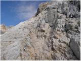 96
96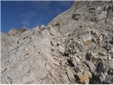 97
97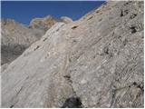 98
98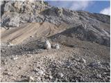 99
99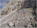 100
100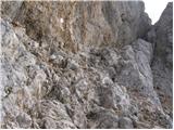 101
101 102
102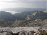 103
103 104
104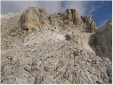 105
105 106
106 107
107 108
108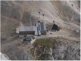 109
109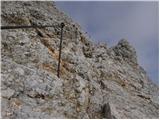 110
110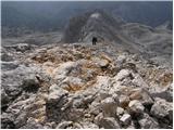 111
111 112
112 113
113 114
114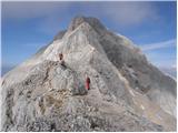 115
115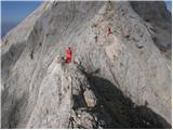 116
116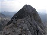 117
117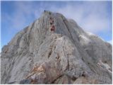 118
118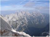 119
119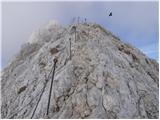 120
120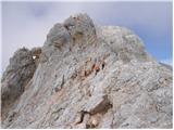 121
121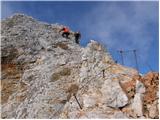 122
122 123
123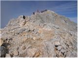 124
124 125
125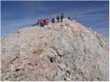 126
126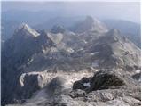 127
127 128
128
Discussion about the trail Rudno polje - Triglav (via Dom Planika and Mali Triglav)
|
| Lunca3. 08. 2023 14:08:30 |
Kaksna pa je cesta z Rudnega polja do manjsega parkirisca? Hvala
|
|
|
|
| 1muha3. 08. 2023 14:33:36 |
|
|
|
|
| Lunca3. 08. 2023 17:53:38 |
|
|
|