 | Rašica - Rašica (Vrh Staneta Kosca) (by road)
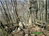
Vrh Staneta Kosca, better known as Rašica, is located north of Ljubljana, specifically above the villages of Rašica and Dobeno. From the top of t...
55 min |
| Rašica - Rašica (Vrh Staneta Kosca) (footpath)
Vrh Staneta Kosca, better known as Rašica, is located north of Ljubljana, specifically above the villages of Rašica and Dobeno. From the top of t...
55 min |
 | Spodnje Dobeno - Rašica (Vrh Staneta Kosca)
Vrh Staneta Kosca, better known as Rašica, is located north of Ljubljana, specifically above the villages of Rašica and Dobeno. From the top of t...
50 min |
 | Preval Prosca - Ključ
Ključ is a forested peak located north of Brezje pri Dobrovi and south of Dolenje vas. There is no view from the top where the registration box w...
1 h |
 | Sveti Urh - Ključ
Ključ is a forested peak located north of Brezje pri Dobrovi and south of Dolenje vas. There is no view from the top where the registration box w...
1 h |
 | Zazid - Jampršnik
Jampršnik is a little-known and even less visited peak located in the mountain chain southwest of Črni Kalo. Despite its modest height, the summi...
1 h |
 | Gora - Trstelj
Trstelj is the highest peak in the Black Hills ridge. The view from the vast summit, where the TV transmitters stand, is split in half. From the ...
50 min |
 | border crossing Lipica - Kokoš (steep way)
Koča na Kokoši is located at the top of Jirmanec, just 5 minutes away from the forested Kokoša. The summit, located south of the Lokavsko polje a...
50 min |
| border crossing Lipica - Kokoš (by road)
Koča na Kokoši is located at the top of Jirmanec, just 5 minutes away from the forested Kokoša. The summit, located south of the Lokavsko polje a...
1 h |
 | Lipica (Škibini) - Kokoš
Koča na Kokoši is located at the top of Jirmanec, just 5 minutes away from the forested Kokoša. The summit, located south of the Lokavsko polje a...
50 min |
 | Povir - Stari tabor
Stari tabor is a scenic peak located west of Divača, north of Lokev and south of the village of Povir. From the summit, where the stamp and the r...
1 h 10 min |
 | Povir - Stari tabor (harder path)
Stari tabor is a scenic peak located west of Divača, north of Lokev and south of the village of Povir. From the summit, where the stamp and the r...
1 h 15 min |
 | Šober (Log) - Tojzlov vrh
Tojzlov vrh is a forested hill located in the eastern part of Kozjak. On the top of the hill stands a small stone monument to the National Libera...
50 min |
 | Križevska vas - Murovica (circular path)
Murovica is a popular excursion point, accessible from the Posavina side, Domžale or from the Moravška valley. There is a bench and a registratio...
50 min |
 | Preval Prosca - Visoki hrib
Visoki hrib is a 602 m high hill located south of Polhov Gradec. The summit, partly covered by forest, offers a beautiful view, especially to the...
50 min |
 | Repnje - Smledniški hrib (Stari grad)
The Old Castle (also Smlednik Castle) is located on a small hill south-west of Valburg. A few years ago, the castle was rebuilt and the nearby tr...
1 h 15 min |
 | Ortnek - Sveti Gregor on Slemena
Sveti Gregor is a settlement located on the scenic ridges. In the middle of the settlement is the parish church of St. Gregory the Great, and nea...
1 h 10 min |
 | Gaber pri Semiču - Smuk (via Semenič)
Smuk is a 545-metre-high peak located above Semič. On the top there is the Church of St. Lawrence, a hunting lodge, and a little further away the...
1 h 10 min |
| Gaber pri Semiču - Smuk (via Smuška cesta)
Smuk is a 545-metre-high peak located above Semič. On the top there is the Church of St. Lawrence, a hunting lodge, and a little further away the...
50 min |
 | Ressnig - Aussicht Petelinz
Aussicht Petelinz is located north-east of Borovel / Ferlach and north or directly above the river Drava / Drau. From the lookout point where the...
1 h |
 | Šahovec - Trebni vrh (Baragova pot)
Trebni vrh is a 581-metre-high hill located south or south-west of Trebnje. On the top of the forested hill there is a bench, and near it there i...
1 h 5 min |
 | Brezje pri Dobrovi - Vrh (Debeli hrib) (via Strmca)
The summit is a 540 m high hill located on the Debeli hrib ridge, a ridge situated between the Ljubljana Marshes and the Horjulščice River valley...
1 h 15 min |
| Vratca - Štanjel (Sveti Danijel) (Vratca - Sv. Danijel (Štanjel))
Štanjel (Sveti Danijel) is located east of Škabrijel (646 m). On the summit are the remains of WWI positions and trenches. On the top there is a...
1 h |
 | Špitalič pri Slovenskih Konjicah - Babček
Babček, an undistinguished peak on the mountain trail between Konjiška Gora and Boč. An asphalt road leads practically under the peak itself. The...
50 min |
 | Žička kartuzija - Babček (via crossing Podgranček)
Babček, an undistinguished peak on the mountain trail between Konjiška Gora and Boč. An asphalt road leads practically under the peak itself. The...
1 h 10 min |
 | Žička kartuzija - Babček
Babček, an undistinguished peak on the mountain trail between Konjiška Gora and Boč. An asphalt road leads practically under the peak itself. The...
1 h 10 min |
 | Dom Frata - Ostri vrh (above Globodol)
Ostri vrh is a 523 m high peak located between Vrbovec, Rdeči Kal, Gorenji, Sredni and Dolenji Globodol, Dolni and Gorni Ajdovec and Podlipa. The...
1 h 20 min |
 | Čatež - Bajturn (Zaplaški hrib) (on north slope)
At 609 metres, Bajturn or Zaplaz Hill is the highest peak in the municipality of Trebnje. At the top there is a nice bench with a table, a box wi...
50 min |
 | Radovljica - Lipnica Castle (Pusti grad above Lipnica) (on natural learning trail)
Castle Lipniški grad or Pusti grad above Lipnica (Waldenberg in German) is located on a lookout over the Sava and Lipnica watercourses, more prec...
1 h 20 min |
 | Zreče (Terme Zreče) - Brinjeva gora (above Zreče) (via farm Pudgrošek)
Brinjeva gora is a remarkable hill located between Zreče and Oplotnica. Brinjeva gora is famous for its several churches, which are located in a ...
50 min |
 | Zreče (Terme Zreče) - Brinjeva gora (above Zreče) (via Golika)
Brinjeva gora is a remarkable hill located between Zreče and Oplotnica. Brinjeva gora is famous for its several churches, which are located in a ...
1 h |
 | Liboje - Kamčič (via organic farm Kralj - southern approach)
Kamčič is a vegetated peak in Posavsko hribovje, located north of Šmohor, between Kotečnik on the left and Veliki Slomnik on the right. It can be...
1 h 10 min |
 | Velenje (Stari trg) - Veliko Gradišče
Gradišče is a hill above Pesje near Velenje. It has two peaks, Veliko and Malo Gradišče. Veliko Gradišče is located to the west of the Church of ...
1 h |
 | Zreče (Terme Zreče) - Sveti Martin (Zlakova) (on PP1)
St Martin's Church is situated on a lookout on the outskirts of Zlakova. From the church you can enjoy a beautiful view of the Pohorje, Brinjeva ...
55 min |
 | Zreče (Terme Zreče) - Golika
Golika is a 609-metre-high peak on Brinjeva Gora, on which the Church of St Neže stands....
50 min |
 | Borovic (road on Hum) - Sveti Duh (Hum) (past Titova špilja)
...
50 min |
 | Buzet Railway Station - Pilj (nad Buzetom)
...
1 h |