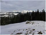
 | Črni Kal - Blegoš (direct way)
Blegoš is a 1,562-metre-high mountain located between the Selška Sora and Poljanska Sora rivers. From the grassy summit, where there is a stamp a...
1 h 10 min |
 | Črni kal - Blegoš (via Prva ravan)
Blegoš is a 1,562-metre-high mountain located between the Selška Sora and Poljanska Sora rivers. From the grassy summit, where there is a stamp a...
1 h 20 min |
 | Bohinjsko sedlo - Možic (direct way)
Možic is a 1,602 m high peak located west of Soriška Planina. At the very summit there is an old military bunker bearing the name of the peak and...
1 h 15 min |
 | Vrh Bače - Možic
Možic is a 1,602 m high peak located west of Soriška Planina. At the very summit there is an old military bunker bearing the name of the peak and...
1 h |
 | Volovljek - Kranjska reber
Kranjska reber, also known as Vrh Kašne planine (1435 m), is a mountain of volcanic origin. From the summit, which has a registration box with a ...
1 h 20 min |
 | End of road - Lepenatka
Lepenatka is a grassy peak located south of the 1557-metre-high Rogatec. From the summit, which has a summit register box and stamp, there is a b...
1 h |
 | Leška gmajna - Lepenatka
Lepenatka is a grassy peak located south of the 1557-metre-high Rogatec. From the summit, which has a summit register box and stamp, there is a b...
1 h 15 min |
 | Tonkina koča na Vršiču - Vršič vrh
Vršič is a 1,737-metre-high mountain situated between the Poštarski dom hut and the Vršič pass. From the summit, where there is a registration bo...
1 h |
 | Bohinjsko sedlo - Dravh (via Lajnar)
Dravh is a 1,547-metre-high peak situated between Sorica and Soriška Planina. From the unforested summit a beautiful view opens across the Škofja...
1 h |
 | Črni Kal - Koprivnik (via Romovec)
Koprivnik is a 1393-meter-high mountain located between Blegoš and Mladi vrh. From the summit, which has a registration box and a stamp, the view...
1 h |
 | Tonkina koča na Vršiču - Sovna glava (on old road)
Sovna Glava is a 1750-meter-high grassy peak situated between Prisank and the Vršič Pass. From the summit, there is a nice view of the peaks risi...
1 h 10 min |
 | Pod Hlipovcem - Komen
At 1684 meters, Komen is the highest peak in the Smrekovec mountain range, which borders between Styria and Carinthia. In good weather, the summi...
55 min |
 | Kolarica - Veliki Travnik (Turnovka)
Veliki Travnik, also known as Turnovka by the locals, is located on the western edge of the Smrekovec mountain range. From the summit, which has ...
1 h 5 min |
 | Rifugio Pelizzo - Monte Mataiur/Matajur (via Dom na Matajure)
Matajur is a panoramic mountain located on the border between Slovenia and Italy. From the summit there is a beautiful view of Kobariški or Bregi...
55 min |
 | Rifugio Pelizzo - Monte Mataiur/Matajur (via Fonte Skrila)
Matajur is a panoramic mountain located on the border between Slovenia and Italy. From the summit there is a beautiful view of Kobariški or Bregi...
1 h 15 min |
 | Prvine - Črni vrh (Čemšeniška planina)
Črni vrh is the highest peak of Čemšeniška planina and, at 1,204 m, the second-highest peak in Posavsko hribovje. The summit has a logbook box bu...
1 h |
 | Ljubelj - Polna peč
Polna peč (also marked as Ravna peč on maps) is situated above the Ljubelj tunnel. From the somewhat precipitous summit there is a nice view of t...
1 h 15 min |
 | Lome - Javornik above Črni vrh
Javornik is a forested peak located southeast of Črni Vrh. In 1972, a lookout tower was erected on the summit, rising above the treetops to provi...
1 h |
| Črni Vrh (Grom) - Javornik above Črni vrh
Javornik is a forested peak located southeast of Črni Vrh. In 1972, a lookout tower was erected on the summit, rising above the treetops to provi...
1 h 10 min |
 | Preval Vrh Ravni - Kojca
Kojca is a panoramic peak rising south of Baška grapa. From the summit, where there is a haystack, fine views extend over the Lower Bohinj Mounta...
1 h 20 min |
 | Podkraj - Sveti Duh (Hrušica)
The Church of the Holy Spirit is located just a few meters below the summit of Sveti Duh on the slopes of the forested Hrušica, in the range betw...
1 h 15 min |
 | Koča na planini Stador - Kobilja glava
Kobilja glava is a 1,475-meter-high peak located east of Tolmin. From the summit, where a cross stands, there is a beautiful view of Krn, the ran...
1 h 15 min |
 | Torka - Gladki vrh (Ratitovec)
Gladki vrh (Ratitovec), at 1,667 meters, is the most visited peak in the Ratitovec range. From its bare summit, which features a panorama board, ...
1 h 20 min |
 | Pod Peco/Koprein-Petzen - Topitza
Topica, or Topitza in German, is a 1649-meter-high peak situated northeast of Železna Kapla. From the summit, where a cross stands, a nice view o...
1 h 15 min |
| Podkraj - Streliški vrh (Hrušica) (west path)
Streliški vrh is a 1,266 m high mountain in the central part of forested Hrušica. From the partly forested summit, a nice view opens only to the ...
1 h 20 min |
 | Kalce - Mali Javornik (Javorniki)
Mali Javornik is a 1219 m high mountain located in the forested ridge of Javorniki. There is no view from the summit itself due to the forest, bu...
1 h |
 | Raspet - Kopa (Cimprovka)
Kopa is a 1360 m high peak or panoramic promontory from which a nice view opens up on Cerkno, the hills surrounding it, Ratitovec, Trnovski gozd,...
1 h 10 min |
 | Bohinjsko sedlo - Slatnik (southeastern peak) (via Lajnar)
Slatnik (southeastern peak) is a panoramic mountain that rises steeply above Baška grapa on one side and descends more gently toward Soriška plan...
1 h 5 min |
| Bohinjsko sedlo - Slatnik (southeastern peak) (past barracks)
Slatnik (southeastern peak) is a panoramic mountain that rises steeply above Baška grapa on one side and descends more gently toward Soriška plan...
1 h 10 min |
 | Avsa - Srednji vrh (on Matajur) (old path)
Srednji vrh is a 1,320-meter-high grassy peak located in the Matajur mountain range. From the summit, a paragliding takeoff point, there is a fin...
1 h 20 min |
 | Feistritzsattel - Arabichl
Arabichl is a panoramic peak situated above the eponymous ski lift. From the summit, a splendid view opens up of the Wechsel group, Stuhleck, and...
1 h 20 min |
 | Teichalm (Angerwirt) - Osser
Osser is a 1548-meter-high peak situated above the Teichalm plateau. From the summit, where a cross stands, a beautiful view opens up over the su...
1 h 20 min |
 | Pension Camping Holzmeister - Osser
Osser is a 1548-meter-high peak situated above the Teichalm plateau. From the summit, where a cross stands, a beautiful view opens up over the su...
1 h 15 min |