Črni Kal - Koprivnik (via Romovec)
Starting point: Črni Kal (1103 m)
| Latitude/Longitude: | 46,1724°N 14,1243°E |
| |
Route name: via Romovec
Walking time: 1 h
Difficulty: easy marked way
Elevation gain: 290 m
Elevation difference along the route: 315 m
Map: Škofjeloško in Cerkljansko hribovje 1:50.000
Recommended equipment (summer):
Recommended equipment (winter): ice axe, crampons
Views: 7.194
 | 2 people like this post |
Access to starting point:
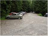
From Škofja Loka we drive towards Gorenja vas, but only to the village Poljane nad Škofjo Loko. Here we continue right in the direction of the village Javorje, on an ascending road which higher brings us to the mentioned village. In the mentioned village, from where also the road from Zaprevala joins, we continue left in the direction towards Blegoš (the crossroads are well marked). The road, which then crosses a few hamlets, higher brings us to a crossroad of multiple roads (Črni Kal), where there is also a somewhat larger parking lot. At the parking lot we notice signposts for Blegoš and Koprivnik.
Route description:
From the parking lot, we head on a cart track in the direction of Koprivnik. After a few 10 steps of walking we will notice signposts by the path, which direct us right (straight Martinj vrh) on an initially poorly visible footpath that steeply ascends a quite overgrown slope. The path ahead becomes more distinct and quickly brings us to the western ridge of Romovec. Further the path ascends even steeper, then flattens and quickly brings us to the vegetated summit of Romovec.
A short descent follows and the path, which all the time runs through the forest, brings us to a pleasant bench by which we notice a logbook box. We continue straight on a level path, which a little further joins a wide cart track. We follow the cart track in the direction of Koprivnik (right downwards Žetina), which gradually starts to ascend more steeply. At the spot where the cart track starts to be overgrown by high grass, we will on the right side notice an initially poorly visible but marked footpath which branches off to the right from the cart track. Further we ascend through initially very dense forest, on a path which higher brings us to partly panoramic slopes, from which a view opens up on the nearby Blegoš. A little further the steepness eases and the path through a blueberry patch quickly brings us to the summit of Koprivnik.

Along the route: Romovec (1247m)
Photos:
 1
1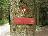 2
2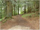 3
3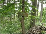 4
4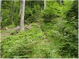 5
5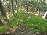 6
6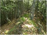 7
7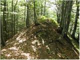 8
8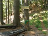 9
9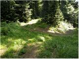 10
10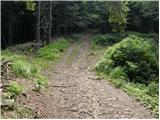 11
11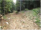 12
12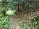 13
13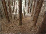 14
14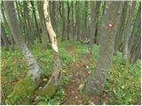 15
15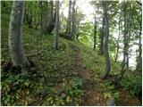 16
16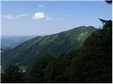 17
17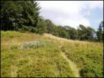 18
18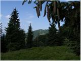 19
19 20
20
Discussion about the trip Črni Kal - Koprivnik (via Romovec)
|
| di1. 10. 2024 18:17:08 |
- If you follow picture 2: The path goes (steeply uphill) and not in the direction of the signpost (probably also possible to go left around - just like right around under the summit).
- Romovec: digital map shows it is a forepeak
- Path continuation to Koprivnik: marking is not optimal, path not yet trodden in places
- Continuation towards Mladi vrh also not well marked, several forks (and you search for the right one).
|
|
|
|
| jozee8. 06. 2025 09:08:48 |
The condition of the markings is still unchanged,
picture 2: the path in the direction of the signpost leads you after about 10 minutes to the path and to the fixed rope. Then it starts descending. Where does this path lead, which also has some old markings (Certainly not the path over Romovec).
The correct path starts right from the parking lot, but there is no sign for it, nor are there markings at the beginning. As if a professional hunter marked the path.
At the top there is no marking for the path towards Mladi vrh.
When walking in the opposite direction, from the bench onwards there is a new marking with the sign Loške poti, but it is misleading. This path does not go over Romovec. Correct is straight uphill, as indicated by the old sign on the ground.
In many places in between there are too many markings (old, new, small)
|
|
|
To post a comment you must log in:
If you do not yet have a username, you must first
register.