Lome - Javornik above Črni vrh
Starting point: Lome (830 m)
| Latitude/Longitude: | 45,9001°N 14,0806°E |
| |
Walking time: 1 h
Difficulty: easy marked way
Elevation gain: 410 m
Elevation difference along the route: 410 m
Map: Nanos 1:50.000
Recommended equipment (summer):
Recommended equipment (winter):
Views: 35.679
 | 3 people like this post |
Access to starting point:
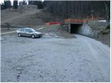
From Logatec we drive towards Idrija or vice versa. In the village Godovič we turn left (from the Logatec side, from the Idrija side right) in the direction of Črni vrh and Col. We follow this road to the turn-off for the village Lome (ski slope Javornik), which is situated 500 meters before the village Črni vrh. Here we turn left and the road soon brings us to the next crossroad, where we continue right in the direction of Gornje Lome (straight ahead to Spodnje Lome). We further follow the road to the parking lot at the ski center Javornik.
From the Primorska side we drive to Ajdovščina, from where we continue towards Col and Črni vrh. 500 meters after the village Črni vrh, the road branches off to the right towards the village Lome. Further, follow the above description.
Route description:
From the parking lot, we continue past the last house in the village on a marked cart track which ascends diagonally across part of the ski slope. The cart track then goes into the forest, where it moderately ascends. During the ascent on the right side we notice an artificial lake intended for snowmaking on the ski slope. After that, the cart track makes a sharp left turn and a little higher joins the forest road, which we follow to the left. After a few steps of walking, we leave the road and head right onto a steep path in the direction of Javornik. The very steep path soon brings us to a cart track near the intermediate station of the two-seater chairlift. Here we continue right and follow the cart track, which has quite a few junctions. All junctions are well marked so that there are no problems with orientation. A little further, we join a wide cart track which comes from Črni vrh.
We continue left and in a gentle ascent after a few minutes we reach Pirnatova koča on Javornik.
From the cottage, we continue right across the meadow upwards in the direction of the tower on Javornik. After a few tens of meters of walking, the path goes into the forest, where it moderately ascends. When we come out of the forest we cross a shorter panoramic slope, then just a little below the summit the path goes into the forest again. A gentle ascent follows through the forest to the summit, where we notice a lookout tower. If we desire a view, we ascend to the top of the tower on our own responsibility, from which a nice view opens up.

Photos:
 1
1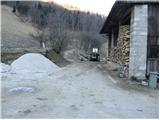 2
2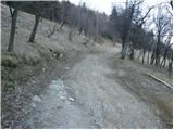 3
3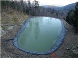 4
4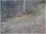 5
5 6
6 7
7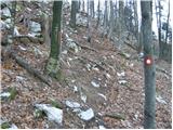 8
8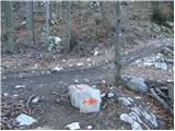 9
9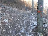 10
10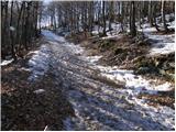 11
11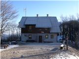 12
12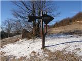 13
13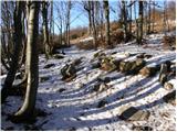 14
14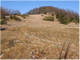 15
15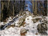 16
16 17
17
Discussion about the trip Lome - Javornik above Črni vrh
|
| Gost26. 01. 2008 |
We hiked this about a year ago, it was quite enjoyable, but the hill doesn't ease up even once, it feels like we ground our knees the whole way.
|
|
|
|
| Gost29. 01. 2008 |
We went on this trail on Saturday. It didn't seem difficult to me, and I'm not in great shape. But it was really a nice outing with sunshine and beautiful views.
|
|
|
|
| Gost4. 02. 2008 |
but Lome are the best.... ski slope, parties for all occasions, the dog Medo and friendly locals...what more could you want
|
|
|
|
| jerry24. 11. 2008 |
The trail is beautiful and well marked, suitable in all seasons. I would only complain about the "principledness" of the caretaker of Pirnatova koča. On our question whether he would let us in with the dog, he said he'd rather not (which he of course has every right to), but just a few minutes later he had no objections to a dog of exactly the same size and even breed! So much for friendliness!
|
|
|
|
| možiček12. 03. 2014 |
Does anyone know if there's a stamp at the top by the tower? Thanks!
|
|
|
|
| MarijanB12. 03. 2014 |
The stamp is placed on one leg of the tower, at least last year it was still there. LP
|
|
|
|
| Lunca23. 07. 2014 |
The stamp is still there.
|
|
|
|
| di6. 05. 2015 |
The path is partially neglected and poorly marked in places.
|
|
|
|
| Kleemen28. 03. 2020 |
Where exactly is the starting point? I went through the whole Lome further from the parking lot (sign on the right, under the ski lift) to the top and turned back at the farm there. There was no marking or sign for the starting point at the parking lot either. 
|
|
|
|
| GregorD29. 03. 2020 |
You go straight through the farmyard on the cart track. So far right into the forest, if looking towards the top of the ski slope.
|
|
|
|
| Kleemen29. 03. 2020 |
Oh haha, then I turned back just before the ski lift. Because I looked at the pictures from the description and there was no sign of that parking lot anywhere, except the lower one where the sign is marked - from the ski slope. Thanks for the info. I'll come next time. 
|
|
|
|
| di29. 03. 2022 19:51:19 |
I've walked this path several times (I even see that I wrote a "complaint" in 2015), which is mainly characterized by getting lost from the marked path - although it's a "transversal" point, even for several hiking circuits.
|
|
|
|
| D0men13. 09. 2022 12:30:36 |
The tower at the summit is no longer intact and is closed.
A new structure is needed.
|
|
|
|
| skiro12312. 01. 2025 18:32:33 |
The tower at the top looks renovated, or rather one can climb it, but it's noted that use is at one's own risk.
|
|
|
|
| plaNinaPirsMajcen21. 12. 2025 17:58:34 |
Hi,
some video impressions from our hike in Primorska.
https://youtu.be/aiCaFR6HG20?si=X-_ryJ5Oc4N5qTsU
The first part of the video is the ascent to Mali Golak, the path to Javornik described above from 2.37 minutes onwards.
The path was muddy. The tower is indeed renovated, but climbing it wasn't pleasant for me.
Javornik rewarded us with a panorama dressed in pastel shades of sunset. Beautiful.
Best, Nina
|
|
|
To post a comment you must log in:
If you do not yet have a username, you must first
register.