 | Mlinše - Zasavska Sveta gora
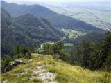
Zasavska Sveta Gora is a popular excursion destination located between Litija and Izlake. From the summit, where the parish church of the Nativit...
1 h 30 min |
 | Vidrga - Zasavska Sveta gora (on forest footpath)
Zasavska Sveta Gora is a popular excursion destination located between Litija and Izlake. From the summit, where the parish church of the Nativit...
1 h 30 min |
| Vidrga - Zasavska Sveta gora (on a cart track)
Zasavska Sveta Gora is a popular excursion destination located between Litija and Izlake. From the summit, where the parish church of the Nativit...
1 h 30 min |
 | Mala voda - Kožljek
Kožljek is a 788 m high peak located west of Koren, more precisely above the village of Samotorica. From the summit, where there are several benc...
1 h 15 min |
 | Mala voda - Koreno
Koreno (also known as Korena) is a 729 m high hill located north of Horjul. From the summit, which features a large cross, the church of St. Moho...
1 h 15 min |
 | Water storage Žegnani studenec - Vaško
Vaško is a little-known mountain in the southeastern ridge of Dobrča. From the summit, there is a nice view toward Jelovica and the Julian Alps. ...
1 h 5 min |
 | Hotovlja - Bukov vrh (by road)
Bukov vrh, where the Church of Our Lady of Sorrows stands, is located in the northwestern part of Polhograjsko hribovje. From the summit, there a...
1 h 30 min |
 | Podgorje - Kojnik (via hunting cottage)
Kojnik is a partly forested peak located in the southern part of Podgorski Kras near the Slovenian-Croatian border. From the summit, which has a ...
1 h 30 min |
 | Planina - Petričev hrib
Petričev hrib is a peak north of Postojna and west of Planina. From the summit, which has a logbook box, there is a nice view of the Notranjska h...
1 h 30 min |
 | Tržič - Kamnek (Milanova pot)
Kamnek (Kamnik on maps, also sometimes Kamnjek) is a panoramic peak above Tržič....
1 h 5 min |
 | Tržič (Slap) - Kamnek (via Dobrivc)
Kamnek (Kamnik on maps, also sometimes Kamnjek) is a panoramic peak above Tržič....
1 h |
 | Lučine - Sivka
Sivka is a grassy peak at the far western end of Polhograjsko hribovje. On clear days, it offers breathtaking views from Snežnik across Javorniki...
50 min |
 | Prelesje - Sivka
Sivka is a grassy peak at the far western end of Polhograjsko hribovje. On clear days, it offers breathtaking views from Snežnik across Javorniki...
1 h |
| Novi Lazi - Livoldski vrh
Livoldski vrh is a forest-covered hill located on the southeastern part of Stojna. The summit has a logbox and stamp....
1 h 10 min |
 | Planina - Grmada (Planinska gora)
Grmada is an 873-meter-high peak rising west of Planinsko polje. Although the summit is forested, a viewpoint just below it offers a stunning vie...
1 h |
 | Planina (Dolnja Planina) - Grmada (Planinska gora) (via Zavrtniki)
Grmada is an 873-meter-high peak rising west of Planinsko polje. Although the summit is forested, a viewpoint just below it offers a stunning vie...
1 h 5 min |
| Planina (Dolnja Planina) - Grmada (Planinska gora) (via Sv. Duh)
Grmada is an 873-meter-high peak rising west of Planinsko polje. Although the summit is forested, a viewpoint just below it offers a stunning vie...
1 h 5 min |
 | Olševek - Štefanja gora (via Apnišče)
Štefanja gora, where the Church of St. Stephen stands, is located above Cerklje na Gorenjskem. Just a few tens of meters below the summit lies th...
1 h 15 min |
 | Preddvor - Štefanja gora (on footpath)
Štefanja gora, where the Church of St. Stephen stands, is located above Cerklje na Gorenjskem. Just a few tens of meters below the summit lies th...
1 h 20 min |
 | Poljana - Smolnik
Smolnik is a steep 1075-meter-high peak a solitary summit below Valvasorjev dom hut rising above the Zavrh (Završnica) valley, with views of St...
1 h 15 min |
 | Poljana - Smolnik (steep path)
Smolnik is a steep 1075-meter-high peak a solitary summit below Valvasorjev dom hut rising above the Zavrh (Završnica) valley, with views of St...
1 h |
 | Polhov Gradec (Božna) - Mala Grmada (via Sveta Uršula)
Mala Grmada is an 853-meter-high peak located southwest of the slightly higher Polhograjska Grmada. From the summit, a beautiful view opens up ov...
1 h 10 min |
 | Bohinjska Češnjica - Rudnica
Rudnica is a panoramic mountain located between the Lower and Upper Bohinj Valleys. From the summit, where there is a register box with a stamp a...
1 h 30 min |
| Srednja vas (Senožeta) - Rudnica
Rudnica is a panoramic mountain located between the Lower and Upper Bohinj Valleys. From the summit, where there is a register box with a stamp a...
1 h 30 min |
 | Nemilje - Sveti Mohor (Zabrekve)
The Church of St. Mohor is located on a 952 m high hill between Zgornja Besnica and Selci. From the church or its nearby surroundings, there is a...
1 h 20 min |
 | Njivica - Sveti Primož in Felicijan (Jamnik)
The Church of St. Primož and Felicijan at Jamnik is located on a scenic grassy ridge rising between Kropa and Podblica. From the church or its ne...
1 h 10 min |
 | Brezovica - Sveti Primož in Felicijan (Jamnik)
The Church of St. Primož and Felicijan at Jamnik is located on a scenic grassy ridge rising between Kropa and Podblica. From the church or its ne...
1 h 20 min |
| Češnjica pri Kropi - Sveti Primož in Felicijan (Jamnik) (via Berigla)
The Church of St. Primož and Felicijan at Jamnik is located on a scenic grassy ridge rising between Kropa and Podblica. From the church or its ne...
1 h 20 min |
 | Nemilje - Sveti Primož in Felicijan (Jamnik) (on marked path)
The Church of St. Primož and Felicijan at Jamnik is located on a scenic grassy ridge rising between Kropa and Podblica. From the church or its ne...
50 min |
 | Rodik - Sveti Socerb (Artviže)
The Church of St. Socerb is located on a panoramic hill above the village of Artviže, which at 817 meters is the highest peak of the Brkini. From...
1 h 20 min |
 | Ribenski most - Tolsti vrh (Talež)
Tolsti vrh is an 883 m high hill located south of Bled, more precisely above the Talež hunting lodge. From the summit, which descends steeply tow...
1 h 15 min |
 | Selski most - Tolsti vrh (Talež)
Tolsti vrh is an 883 m high hill located south of Bled, more precisely above the Talež hunting lodge. From the summit, which descends steeply tow...
1 h 15 min |
 | Trojane - Lipovec
Lipovec is an 848-meter-high peak located above the pastures of Lipovec. On clear days, the summit offers views of the Posavsko hribovje, Kum, Me...
1 h 30 min |
 | Jasen - Ahac
Ahac (or Sv. Ahac) is a 799-meter-high peak located east of Ilirska Bistrica. The summit hosts a summit logbox, a cross, and ruins of the former ...
1 h |
| Vrbovo - Ahac
Ahac (or Sv. Ahac) is a 799-meter-high peak located east of Ilirska Bistrica. The summit hosts a summit logbox, a cross, and ruins of the former ...
1 h |
 | Tržič (Čegelše) - Veliki vrh above Završnik
Veliki vrh above Završnik is a 968 m high mountain located in the Pirmance ridge, north to northeast of Tržič. From the grassy summit, which feat...
1 h 20 min |
| Podljubelj - Veliki vrh above Završnik
Veliki vrh above Završnik is a 968 m high mountain located in the Pirmance ridge, north to northeast of Tržič. From the grassy summit, which feat...
1 h 20 min |
 | Brezje nad Kamnikom - Vovar (western way)
A viewless hill in front of the Kamnik mountains. In recent times, due to storms, it is crisscrossed with cart tracks for log extraction.Below th...
1 h |
| Brezje nad Kamnikom - Vovar (northern way)
A viewless hill in front of the Kamnik mountains. In recent times, due to storms, it is crisscrossed with cart tracks for log extraction.Below th...
1 h |
 | Žiri - Javorč
Javorč is a 901-meter-high peak located northeast of Žiri. The summit, featuring a logbox with a logbook, lies at the edge of a larger clearing, ...
1 h 15 min |
 | Babni Vrt - Gradišče (Pustinjak) (through forest and past Sveti Lovrenc)
Gradišče or Pustinjak (also Gradišče nad Bašljem) is an 871-meter-high peak located above the Belica stream, which lies below the 2,132-meter-hig...
1 h 15 min |
 | Col - Špiček (Špečk)
Špiček (locals call it Špečk) is a peak located north to north-east of Col. A cross on the summit honors St. Hubert and commemorates the first an...
55 min |
 | Col - Špiček (Špečk) (via Križna gora)
Špiček (locals call it Špečk) is a peak located north to north-east of Col. A cross on the summit honors St. Hubert and commemorates the first an...
1 h 10 min |
 | Col - Križna gora above Col (via Špiček)
Križna gora is a 957-meter-high peak located north of Col. From the summit, which is forested on the northern side, beautiful views open up to th...
1 h 10 min |
 | Col - Križna gora above Col
Križna gora is a 957-meter-high peak located north of Col. From the summit, which is forested on the northern side, beautiful views open up to th...
55 min |
 | Olševek - Apnišče (west path)
Apnišče is a 740 m high mountain between Možjanca and Štefanja gora. It is the highest point of the Šenčur municipality. The forested summit offe...
55 min |
 | Olševek - Apnišče (via Šterna)
Apnišče is a 740 m high mountain between Možjanca and Štefanja gora. It is the highest point of the Šenčur municipality. The forested summit offe...
55 min |
| Adergas - Apnišče (via Šterna)
Apnišče is a 740 m high mountain between Možjanca and Štefanja gora. It is the highest point of the Šenčur municipality. The forested summit offe...
1 h |
 | Preddvor - Apnišče (on footpath)
Apnišče is a 740 m high mountain between Možjanca and Štefanja gora. It is the highest point of the Šenčur municipality. The forested summit offe...
1 h 15 min |
 | Blejska Dobrava (cemetery) - Hom at Bled (via Katarina)
Hom is an 834-meter-high hill rising north above the villages of Zasip and Podhom near Bled, or south of the village Blejska Dobrava near Jesenic...
1 h 25 min |
 | Blejska Dobrava (cemetery) - Hom at Bled (on east slope)
Hom is an 834-meter-high hill rising north above the villages of Zasip and Podhom near Bled, or south of the village Blejska Dobrava near Jesenic...
1 h 5 min |
 | Poljane (Spodnje Gorje) - Boršt (by road)
Boršt is a 931-meter-high vegetated peak located 4 km northwest of Bled, or east of the Mežakla Plateau. Between it and the neighboring peak Hom ...
1 h |
 | Kočna - Boršt (via Vrše)
Boršt is a 931-meter-high vegetated peak located 4 km northwest of Bled, or east of the Mežakla Plateau. Between it and the neighboring peak Hom ...
1 h 20 min |
 | Trate (Blejska Dobrava) - Boršt
Boršt is a 931-meter-high vegetated peak located 4 km northwest of Bled, or east of the Mežakla Plateau. Between it and the neighboring peak Hom ...
1 h |
 | Ukova (Jesenice) - Mirca (via Pekova plan'ca)
Mirca (Merca in dialect) is one of the peaks in the southern Karawanks at an elevation of 1025 meters. It rises north above the center of Jesenic...
1 h 20 min |
 | Murova - Mirca
Mirca (Merca in dialect) is one of the peaks in the southern Karawanks at an elevation of 1025 meters. It rises north above the center of Jesenic...
1 h 10 min |
 | Jeršiče - Baba (at Javorniki)
Baba is a 1,085-meter-high peak located between the Javorniki ridge and Sveta Trojica. From its grassy summit, nice views open up to the Javornik...
1 h 30 min |
 | Bele Vode (Kovač) - Sveti Križ above Bele Vode (on south ridge)
The Church of St. Cross is located on Kriška gora, formerly called Oslovska gora. Kriška gora rises above Beli Vodi, or above the streams Ljubija...
1 h 10 min |
 | Mežica - Andrejev vrh (by cart track)
Andrejev vrh is a forest-covered peak located between Mežica and Leše. On the summit there is a bench and a summit register box with a logbook....
1 h 15 min |
| Mežica - Andrejev vrh (past the chapel)
Andrejev vrh is a forest-covered peak located between Mežica and Leše. On the summit there is a bench and a summit register box with a logbook....
1 h 20 min |
| Leše - Andrejev vrh (past Leše churches and on cart track)
Andrejev vrh is a forest-covered peak located between Mežica and Leše. On the summit there is a bench and a summit register box with a logbook....
1 h 30 min |
 | Selca - Sveti Križ above Selca
The Church of the Holy Cross above Selca is situated on a panoramic hill from which a beautiful view opens up over part of the Škofjeloško hribov...
1 h 15 min |
| Železniki - Sveti Križ above Selca (via Štalca)
The Church of the Holy Cross above Selca is situated on a panoramic hill from which a beautiful view opens up over part of the Škofjeloško hribov...
1 h 15 min |
 | Senično - Planica (Paragliding site Gozd) (gentle path)
Planica is a 926-meter peak located above the village of Gozd. From the summit, where the JPK Kriška gora cottage stands, a nice view opens up ov...
1 h 15 min |
| Senično - Planica (Paragliding site Gozd) (steep path)
Planica is a 926-meter peak located above the village of Gozd. From the summit, where the JPK Kriška gora cottage stands, a nice view opens up ov...
1 h 10 min |
| Pristava - Planica (Paragliding site Gozd)
Planica is a 926-meter peak located above the village of Gozd. From the summit, where the JPK Kriška gora cottage stands, a nice view opens up ov...
1 h 20 min |
 | Šenturška Gora - Prgozdnik (Martinova pot)
Prgozdnik is a 1013 meters high peak, which is situated on the eponymous ridge, between the settlements Ambrož pod Krvavcem, Šenturška Gora, Apno...
1 h 5 min |
 | Apno - Prgozdnik (Martinova pot)
Prgozdnik is a 1013 meters high peak, which is situated on the eponymous ridge, between the settlements Ambrož pod Krvavcem, Šenturška Gora, Apno...
1 h 10 min |
 | Škofja Loka - Vrh soteske (Križna gora)
Vrh soteske is a 735 meters high peak, which is situated on the southwestern part of Križna gora. From the top, which is overgrown by the forest,...
1 h 25 min |
| Vešter - Vrh soteske (Križna gora)
Vrh soteske is a 735 meters high peak, which is situated on the southwestern part of Križna gora. From the top, which is overgrown by the forest,...
1 h 15 min |
 | Šentviška Gora - Črvov vrh
Črvov Vrh, also known as Črvov Grič, is the highest peak of the Šentviška Planota at 974 metres. The plateau rises above the right bank of the Id...
1 h 10 min |
 | Šentviška Gora - Bukovski vrh
Bukovski Vrh (918 m) lies above the settlement of Bukovski Vrh, more precisely above the Pri Pircu homestead. From the grassy summit there is a f...
1 h 30 min |
 | Hotavlje - Vrh Slajke
Vrh Slajke is a 790-metre hill above Hotavlje, specifically above the right bank of the Kopačnica. From the summit, where an antenna tower stands...
1 h 15 min |
| Hotavlje - Vrh Slajke (via Bela)
Vrh Slajke is a 790-metre hill above Hotavlje, specifically above the right bank of the Kopačnica. From the summit, where an antenna tower stands...
1 h 30 min |
| Podgora - Vrh Slajke
Vrh Slajke is a 790-metre hill above Hotavlje, specifically above the right bank of the Kopačnica. From the summit, where an antenna tower stands...
1 h 25 min |
 | Ledinica - Krog (Ledinski grič)
Krog is a 940-metre-high peak on the western part of the Ledinski grič ridge, between the streams Jerešča and Ledinščicaboth left tributaries of ...
1 h 15 min |
 | Selca - Lepo brdo
Lepo brdo is a 778-metre hill rising above the Selca and Studeno settlements....
1 h |
 | Veliko Tinje - Repnikov vrh
Repnikov vrh is a 988-meter-high peak on Pohorje, located between Planina pod Šumikom and Urh. The summit is in the middle of the forest, along a...
1 h 25 min |
 | Zreče (Terme Zreče) - Golek (steep path)
Golek is a 769-meter-high peak located northwest of Zreče. The summit has a logbook box with book and stamp, plus a bench; a short distance (a fe...
1 h 20 min |
 | Übelbach - Schankkogel
Schankkogel is, with its 1049 meters, the highest peak of the Notberg hill near the settlement of Guggenbach (close to Übelbach) in Steiermark.Be...
1 h 30 min |
 | Übelbach - Schankkogel (steep path)
Schankkogel is, with its 1049 meters, the highest peak of the Notberg hill near the settlement of Guggenbach (close to Übelbach) in Steiermark.Be...
1 h 30 min |
 | Deutschfeistritz - Parmaseggkogel (via Kugelberg)
Parmaseggkogel is a 785-meter-high peak between the town of Deutschfeistritz and the municipality of Frohnleiten, northwest of Graz.A cross and s...
1 h 15 min |