 | Koča pod slapom Rinka - Mrzla gora
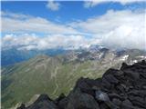
This hard-to-reach mountain is located on the border with Austria in the Kamnik and Savinja Alps. From the top you can enjoy a beautiful view of ...
4 h 30 min |
 | Trate / Johannsenruhe - Hochstuhl/Stol (climbing way)
At 2236 m, Stol is the highest peak in the Karavanke Mountains. From the summit, which has a registration box and a stamp, we have a beautiful vi...
3 h 20 min |
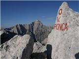
 | Dom v Tamarju - Zadnja Ponca / Ponza di Detro
Zadnja Ponca is a 2242m high peak located on the narrow and precipitous Ponc ridge. The summit, which is not accessible to everyone, offers a bea...
4 h |
 | Koča pod slapom Rinka - Turska gora (via Kotliči)
The mountain is located above the Logarska Valley and the Kamniška Bistrica Valley. From the top there is a beautiful view towards the neighbouri...
4 h 30 min |
 | Koča pod slapom Rinka - Turska gora (via Turski žleb)
The mountain is located above the Logarska Valley and the Kamniška Bistrica Valley. From the top there is a beautiful view towards the neighbouri...
4 h 15 min |
 | Dom v Tamarju - Visoka Ponca
Visoka Ponca is located on the border with Itali and has beautiful views of the mountains above the Tamar Valley and the Italian Julian Alps. Jal...
4 h |
 | Reißkofelbad - Reißkofel (via bivouac)
Reißkofel is a 2371 metre high mountain in the Zilj Alps. The summit on which the cross stands also has a registration box. The view from the top...
4 h 30 min |
 | Koča pod slapom Rinka - Štajerska Rinka (via Turski žleb)
Štajerska Rinka is a 2374 m high mountain rising steeply above Okrešl, more precisely to the east of the more visited Koroška Rinka. From the top...
4 h 45 min |
 | Ravenska Kočna - Štajerska Rinka (Slovenska pot)
Štajerska Rinka is a 2374 m high mountain rising steeply above Okrešl, more precisely to the east of the more visited Koroška Rinka. From the top...
4 h 30 min |
| Ravenska Kočna - Štajerska Rinka (via Žrelo)
Štajerska Rinka is a 2374 m high mountain rising steeply above Okrešl, more precisely to the east of the more visited Koroška Rinka. From the top...
4 h 30 min |
| Ravenska Kočna - Štajerska Rinka (hunting path)
Štajerska Rinka is a 2374 m high mountain rising steeply above Okrešl, more precisely to the east of the more visited Koroška Rinka. From the top...
4 h 45 min |
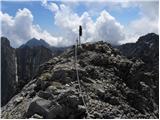
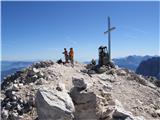
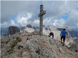
 | Ruski križ - Križ
Križ is a 2140 m high mountain located north-east of the Kriški Podi. From the top, where there is a registration box with a stamp, you have a be...
4 h 45 min |
 | Pecol - Cima di Terrarossa (Leva)
Cima di Terrarossa is a scenic peak located between Jôf di Montasio and Viš. From the summit, which is often full of ibex, you can admire the hig...
4 h 30 min |
 | Koča pod slapom Rinka - Koroška Rinka
Koroška Rinka (also Križ) is a 2433 m high mountain rising steeply above Lediny and Okrešlje. From the top, which has a registration box and a st...
5 h |
 | Koča pod slapom Rinka - Koroška Rinka (via Turski žleb)
Koroška Rinka (also Križ) is a 2433 m high mountain rising steeply above Lediny and Okrešlje. From the top, which has a registration box and a st...
5 h |
| Ravenska Kočna - Koroška Rinka (Slovenska pot)
Koroška Rinka (also Križ) is a 2433 m high mountain rising steeply above Lediny and Okrešlje. From the top, which has a registration box and a st...
4 h 15 min |
| Belska Kočna - Koroška Rinka
Koroška Rinka (also Križ) is a 2433 m high mountain rising steeply above Lediny and Okrešlje. From the top, which has a registration box and a st...
4 h 45 min |
| Ravenska Kočna - Koroška Rinka (via Žrelo)
Koroška Rinka (also Križ) is a 2433 m high mountain rising steeply above Lediny and Okrešlje. From the top, which has a registration box and a st...
4 h 15 min |
| Ravenska Kočna - Koroška Rinka (hunting path)
Koroška Rinka (also Križ) is a 2433 m high mountain rising steeply above Lediny and Okrešlje. From the top, which has a registration box and a st...
4 h 30 min |
 | Gozdec - Vrh Laške Planje
Vrh Laške Planje (Lasca Plagna) is a 2,448-metre-high peak located on the border ridge between Itali and Slovenia. From the top, you can enjoy a ...
5 h |
 | Koča pod slapom Rinka - Kranjska Rinka (via Turski žleb)
Kranjska Rinka is the highest of all Markets. From the top, which has a registration book, you have the best view towards Skuti. The rest of the ...
5 h 5 min |
| Ravenska Kočna - Kranjska Rinka (Slovenska pot)
Kranjska Rinka is the highest of all Markets. From the top, which has a registration book, you have the best view towards Skuti. The rest of the ...
4 h 35 min |
| Belska Kočna - Kranjska Rinka
Kranjska Rinka is the highest of all Markets. From the top, which has a registration book, you have the best view towards Skuti. The rest of the ...
5 h 5 min |
| Ravenska Kočna - Kranjska Rinka (via Žrelo)
Kranjska Rinka is the highest of all Markets. From the top, which has a registration book, you have the best view towards Skuti. The rest of the ...
4 h 35 min |
| Ravenska Kočna - Kranjska Rinka (hunting path)
Kranjska Rinka is the highest of all Markets. From the top, which has a registration book, you have the best view towards Skuti. The rest of the ...
4 h 50 min |
 | Lienzer Dolomitenhütte - Kleine Gamswiesenspitze
Kleine Gamswiesenspitze is a steep and sharp mountain located near the larger Große Gamswiesenspitze. The precipitous summit offers a beautiful v...
3 h 30 min |
 | Aljažev dom v Vratih - Begunjski vrh (Tominšek route)
Begunjski vrh is a 2461 m high mountain located in the heart of the highest mountains in the Julian Alps. From the top, which has a registration ...
4 h 50 min |
 | Rifugio Cercena - Cima Montanel
Cima Montanel is a 2,461-metre-high peak overloking the Piave Valley in the Carnioan Pre-Alps. The summit on which the cross is erected is a rema...
4 h 40 min |
| Rifugio Padova - Cima Montanel (via Forcella di Crodon)
Cima Montanel is a 2,461-metre-high peak overloking the Piave Valley in the Carnioan Pre-Alps. The summit on which the cross is erected is a rema...
4 h 50 min |
 | Edelweiss - Monte Volaia / Wolayer Kopf (path 176)
Italian Monte Volaia, German Wolayer Kopf is a 2470 m high peak in the main ridge Carnic Alps west of the highest peak Monte Coglians in the subg...
3 h 45 min |
| Collina - Monte Volaia / Wolayer Kopf (path 141)
Italian Monte Volaia, German Wolayer Kopf is a 2470 m high peak in the main ridge Carnic Alps west of the highest peak Monte Coglians in the subg...
4 h |
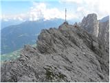
 | Ruski križ - Špik (via Koča v Krnici)
Špik is a 2,472 m high mountain located in the heart of the Martuljek Mountains. From the top, which is clearly visible from the road leading thr...
5 h |
 | Ravenska Kočna - Dolgi hrbet (past the cableway and on Frischaufova pot)
Dolgi Hrbet is located between Grintovec and Skuta. The precipitous peak offers a beautiful view of the heart of the Kamnik and Savinja Alps. Dol...
5 h |
 | Ravenska Kočna - Dolgi hrbet (umik Žrela and on Frischaufova pot)
Dolgi Hrbet is located between Grintovec and Skuta. The precipitous peak offers a beautiful view of the heart of the Kamnik and Savinja Alps. Dol...
5 h 5 min |
| Ravenska Kočna - Dolgi hrbet (via Štularjeva planina and on path Frischaufova pot)
Dolgi Hrbet is located between Grintovec and Skuta. The precipitous peak offers a beautiful view of the heart of the Kamnik and Savinja Alps. Dol...
5 h |
 | Lienzer Dolomitenhütte - Große Gamswiesenspitze (Normalweg)
Große Gamswiesenspitze is a 2488 m high mountain located in the heart of the Lienz Dolomites. From the summit, which has a sign-in box, you can e...
3 h 30 min |
 | Aljažev dom v Vratih - Triglavski dom na Kredarici (Tominšek route)
Triglavski dom na Kredarici is Slovenia's highest mountain hut. It is open all year round but only on an emergency basis out of season. From the ...
4 h 50 min |
 | Pecol - Foronon del Buinz / Špik nad Nosom (Ceria Merlone)
Foronon del Buinz is a 2531 m high mountain located in the mountain ridge between Jôf di Montasio and Viš. The rocky peak offers a view of the Vi...
3 h 45 min |
 | Klammbrückl - Weittalspitze (Allmaier Toni Weg)
Weittalspitze is a 2,539-metre-high peak in the Lienz Dolomites. The summit is located south of the mountain pasture Kerschbaumeralm. From the su...
4 h 30 min |
 | Ravenska Kočna - Jezerska Kočna (past the cableway and on Kremžarjeva pot)
Jezerska Kočna is located west of Grintovec. From the top there is a very nice view towards Grintovec. Karawanks and the Gorenjska plain are also...
5 h |
| Ravenska Kočna - Jezerska Kočna (umik Žrela and on Kremžarjeva pot)
Jezerska Kočna is located west of Grintovec. From the top there is a very nice view towards Grintovec. Karawanks and the Gorenjska plain are also...
5 h 5 min |
| Ravenska Kočna - Jezerska Kočna (via Štularjeva planina and on path Kremžarjeva pot)
Jezerska Kočna is located west of Grintovec. From the top there is a very nice view towards Grintovec. Karawanks and the Gorenjska plain are also...
5 h |
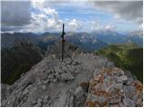
 | Vršič - Prisank / Prisojnik (ridge way)
Prisank is a 2547 m high mountain located above the valleys of Mlinarica, Krnica and Suha Pišnica. From the top of the peak, where the registrati...
3 h 30 min |
| Vršič - Prisank / Prisojnik (Kopiščarjeva pot)
Prisank is a 2547 m high mountain located above the valleys of Mlinarica, Krnica and Suha Pišnica. From the top of the peak, where the registrati...
3 h 50 min |
 | Koča na Gozdu - Prisank / Prisojnik (Hanzova pot)
Prisank is a 2547 m high mountain located above the valleys of Mlinarica, Krnica and Suha Pišnica. From the top of the peak, where the registrati...
5 h |
| Erjavčeva koča na Vršiču - Prisank / Prisojnik (Kopiščarjeva pot)
Prisank is a 2547 m high mountain located above the valleys of Mlinarica, Krnica and Suha Pišnica. From the top of the peak, where the registrati...
4 h |
| Erjavčeva koča na Vršiču - Prisank / Prisojnik (ridge path)
Prisank is a 2547 m high mountain located above the valleys of Mlinarica, Krnica and Suha Pišnica. From the top of the peak, where the registrati...
3 h 45 min |
 | Erjavčeva koča na Vršiču - Prisank / Prisojnik (via Kajzljeva škrbina)
Prisank is a 2547 m high mountain located above the valleys of Mlinarica, Krnica and Suha Pišnica. From the top of the peak, where the registrati...
5 h |
| Vršič - Prisank / Prisojnik (via Kajzljeva škrbina)
Prisank is a 2547 m high mountain located above the valleys of Mlinarica, Krnica and Suha Pišnica. From the top of the peak, where the registrati...
4 h 45 min |
 | Rifugio Tolazzi - Monte Capolago / Seekopf
Monte Capolago is a very scenic mountain located on the border between Austria and Itali, directly above Lake Wolayer See. From the top, you have...
3 h 45 min |
 | Sella Nevea - Visoki Kanin (Via ferrata Divisione Julia)
Visoki Kanin is the highest peak of the Kanin Mountains. From the summit on which the cross stands, you have a beautiful view of the western Juli...
4 h 45 min |
 | Maria Waldrast - Lämpermahdspitze (pot preko severnega grebena)
Lämpermahdspitze is a slightly lesser-known mountain, located to the south of the famous and popular Serles. Despite its lower altitude and lower...
3 h 15 min |
 | Lienzer Dolomitenhütte - Teplitzer Spitze
Teplitzer Spitze is a 2613 m high mountain located south-west of Lake Laserzsee. From the small, spacious summit, we have a beautiful view of the...
3 h |
 | Axamer Lizum - Marchreisenspitze (Lustige Bergler Steig)
Marchreisenspitze is a beautifully shaped and remotely recognisable mountain and one of the main peaks in the Kalkkögel, the northern bastion of ...
3 h 30 min |
 | Colfosco - Sassongher
Cima Sassongher or Sassongher Spitze is a 2,665-metre-high mountain rising steeply above Alta Badia. The mountain is located in the Puez mountain...
3 h 30 min |
 | Pri Mlinču - Mangart (slovenska pot)
Mangart (also Mangrt, both spellings are grammatically correct) is a mountain that receives a very high number of visitors in summer. Access to t...
4 h 45 min |
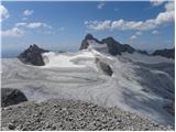
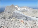
 | Türlwandhütte - Hunerkogel
Hunerkogel is a 2685 metre high peak above the Schladminger Glacier. From the top you have a beautiful view of the peaks above the glacier, and y...
4 h |
 | Capanna Alpina - Vallon Bianco
Vallon Bianco (Valun Blanch in Ladin) is a 2688 metre high peak above the Valle di Fanes and Val Travenanzes. From the top, where a small cross a...
4 h 20 min |
| Sant'Uberto - Vallon Bianco
Vallon Bianco (Valun Blanch in Ladin) is a 2688 metre high peak above the Valle di Fanes and Val Travenanzes. From the top, where a small cross a...
5 h 5 min |
| Rifugio Pederü - Vallon Bianco
Vallon Bianco (Valun Blanch in Ladin) is a 2688 metre high peak above the Valle di Fanes and Val Travenanzes. From the top, where a small cross a...
4 h 40 min |
 | Lienzer Dolomitenhütte - Galitzenspitzen
Galitzenspitzen is a 2710 m high mountain located in the ridge between the Roter Turm and the highest peak Lienz Dolomites Große Sandspitze. The ...
4 h |
 | Alba di Canazei - Colac (path 646)
Colac is a 2715 m high mountain located in the west of the Marmolada mountain group. From the summit on which the cross stands, there is a beauti...
4 h |
 | Klammbrückl - Spitzkofel
Spitzkofel is a 2,717-metre-high mountain in the Lienz Dolomites. From the top, where a large cross stands, you have a very nice view of the whol...
5 h |
 | Lienzer Dolomitenhütte - Laserzkopf
Laserzkopf is a 2718 m high mountain located near the highest peak of the Lienz Dolomites. From the top with a cross, you have a beautiful view o...
3 h 30 min |
 | Türlwandhütte - Kleiner Gjaidstein (via Hunerscharte)
Kleiner Gjaidstein is a 2735 m high peak in the Dachstein mountain group. The peak is located on a ridge between the Schladminger Glacier and the...
4 h 30 min |
 | Prebersee - Roteck
Roteck is a 2742m high peak located north of the Tamsweg in the heart of the Low Tatras. From the summit on which the cross stands, there is a be...
4 h |
 | Piano Fiscalino / Fischleinboden - Monte Paterno (Ferrata De Luca-Innerkofler)
Monte Paterno is a 2744 metre high lookout. The view from the top is spectacular on all sides, with the Tri Cine/Tre Cime to the west standing ou...
4 h 10 min |
 | Rifugio Tolazzi - Pilastro del Coglians (via Rifugio Marinelli)
Pilastro del Coglians is a 2750 m high peak located east of Monte Coglians on the border between Austria and Itali. There is also a registration ...
3 h 55 min |
 | Pecol - Jôf di Montasio/Montaž (over Pipan's ladder)
Jôf di Montasio is one of the most majestic mountains in the Julian Alps and with its 2753m it is the second highest. The authentic Slovenian nam...
3 h 30 min |
 | Pecol - Jôf di Montasio/Montaž (via Findenegg couloir)
Jôf di Montasio is one of the most majestic mountains in the Julian Alps and with its 2753m it is the second highest. The authentic Slovenian nam...
3 h 45 min |
 | Lienzer Dolomitenhütte - Große Sandspitze (Ari Schübel)
At 2772 m, Große Sandspitze is the highest peak in the Lienz Dolomites. From the summit, which has a sign-in box, we have a wonderful view of the...
3 h 45 min |
 | Capanna Alpina - Furcia Rossa III
Furcia Rossa III is a 2791 m high peak in a slightly more secluded ridge over which the Fridensweg / Via della pace leads. At the top, next to th...
4 h 30 min |
| Rifugio Pederü - Furcia Rossa III
Furcia Rossa III is a 2791 m high peak in a slightly more secluded ridge over which the Fridensweg / Via della pace leads. At the top, next to th...
4 h 50 min |
 | Türlwandhütte - Hoher Gjaidstein (via Hunerscharte)
Hoher Gjaidstein is a 2,792-metre-high peak in the Dachstein mountain group. The peak is located on a ridge between the Schladminger Glacier and ...
5 h |
 | Passo di Costalunga / Karerpass - Cima Latemar / Latemarspitze
Cima Latemar (also Schenon Latemar, German Latemarspitze) is a 2800 m high peak in the Latemar mountain group. The summit, on which a large cross...
3 h 40 min |
| Passo di Costalunga / Karerpass - Cima Latemar / Latemarspitze (via Malga Vallace)
Cima Latemar (also Schenon Latemar, German Latemarspitze) is a 2800 m high peak in the Latemar mountain group. The summit, on which a large cross...
3 h 50 min |
 | Passo di Costalunga / Karerpass - Roda di Vael / Rotwand (via Passo dal Vaiolon)
Roda di Vael (German: Rotwand) is a 2806 metre high mountain in the Catinaccio (Rosengarten) mountain group. The mountain is mainly known for its...
4 h |
 | Ristorante Pietofana - Cima Formenton (via Rifugio Pomedes)
Cima Formenton is a 2830 m high peak in the Tofana mountain group. The mountain is located to the north of the better known Tofana di Dentro, and...
5 h 5 min |
 | Türlwandhütte - Kleiner Koppenkarstein (via Hunerscharte)
Kleiner Koppenkarstein is a 2,832-metre-high peak in the Dachstein mountain group. The unremarkable peak is located in the Koppenkarstein ridge, ...
4 h 15 min |
 | Türlwandhütte - Großer Koppenkarstein (via Hunerscharte)
Großer Koppenkarstein is a 2865 metre high mountain in the Dachstein mountain group. It is located above the Schladminger Glacier. From the top w...
4 h 50 min |
 | Parking Erichhütte - Hoher Kopf (path 432)
Hocher Kopf is located in the Berchtesgaden Alps, west of the highest peak, Höchkonig. The summit is well visited, especially because of the Köni...
4 h 45 min |
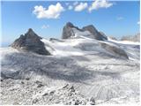
 | Obermoos - Zugspitze (Stopselziehersteig)
At 2962 metres, Zugspitze is the highest peak in the Wetterstein mountain group and the highest peak in Germany. The mountain is located south of...
5 h |
 | Piano Fiscalino / Fischleinboden - Croda Rossa di Sesto (Via Ferrata Croda Rossa)
Croda Rossa di Sesto (German: Sextner Rotwand, also Zehner) is a 2,965-metre-high mountain in the Sexten Dolomites (Dolomiti di Sesto). The mount...
5 h |
 | Rifugio Pederü - Cima Nove / Neunerspitze
The Italian Cima Nove or Sasso delle Nove, the German Neuner or Neunerspitze, the Ladin Sas dles Nü or Nönör is a 2,968-metre high peak in the Fa...
4 h 50 min |
 | Seichenbrunn - Glödis
Glödis or Glödisspitze is a 3206 metre high mountain in the Schober mountain group in the High Tauern National Park (Nationalpark Hohe Tauern). F...
5 h |