 | Jezero - Krim (via Ledenica)
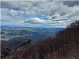
Krim is a 1107 m high mountain rising south of the Ljubljana Marshes. From the top of the mountain, where the mountain lodge and a number of tran...
2 h 30 min |
 | Strahomer - Krim (via Strmec)
Krim is a 1107 m high mountain rising south of the Ljubljana Marshes. From the top of the mountain, where the mountain lodge and a number of tran...
2 h 10 min |
| Strahomer - Krim (via Kramarca)
Krim is a 1107 m high mountain rising south of the Ljubljana Marshes. From the top of the mountain, where the mountain lodge and a number of tran...
2 h 10 min |
 | Vrbljene - Krim
Krim is a 1107 m high mountain rising south of the Ljubljana Marshes. From the top of the mountain, where the mountain lodge and a number of tran...
2 h 15 min |
| Tomišelj - Krim
Krim is a 1107 m high mountain rising south of the Ljubljana Marshes. From the top of the mountain, where the mountain lodge and a number of tran...
2 h 15 min |
| Jezero - Krim (via homestead Špelin)
Krim is a 1107 m high mountain rising south of the Ljubljana Marshes. From the top of the mountain, where the mountain lodge and a number of tran...
2 h 20 min |
 | Trbovlje - Kum (via Čebulova dolina)
At 1220 metres, Kum is the highest peak of Posavsko hribovje. Because it rises above Zasavje, some people call it the Zasavje Triglav. On the sum...
3 h 30 min |
 | Zidani Most - Kum (through Škratova dolina (old path))
At 1220 metres, Kum is the highest peak of Posavsko hribovje. Because it rises above Zasavje, some people call it the Zasavje Triglav. On the sum...
3 h |
 | Hrastnik (Podkraj) - Kum (via Matca)
At 1220 metres, Kum is the highest peak of Posavsko hribovje. Because it rises above Zasavje, some people call it the Zasavje Triglav. On the sum...
2 h 55 min |
| Zidani Most - Kum (through Škratova dolina (new path))
At 1220 metres, Kum is the highest peak of Posavsko hribovje. Because it rises above Zasavje, some people call it the Zasavje Triglav. On the sum...
3 h 5 min |
 | Lozice - Vojkova koča na Nanosu
Vojkova koča is located on the southern edge of the Nanoše plateau, close to Pleše, a peak that is clearly visible from the motorway. From the hu...
2 h 45 min |
| Hrašče - Vojkova koča na Nanosu (via Brižnik)
Vojkova koča is located on the southern edge of the Nanoše plateau, close to Pleše, a peak that is clearly visible from the motorway. From the hu...
3 h |
| Hrašče - Vojkova koča na Nanosu (past troughs)
Vojkova koča is located on the southern edge of the Nanoše plateau, close to Pleše, a peak that is clearly visible from the motorway. From the hu...
3 h |
 | Stomaž - Veliki Modrasovec
Veliki Modrasovec is located in the southern part of the Trnovo Forest near Predmeja. On the top of the hill is an old military building which yo...
2 h 35 min |
 | Hrastnik - Mrzlica (via Klobuk)
Mrzlica has become an extremely popular excursion point in the last few years, especially for visitors from the Savinjska Valley and Zasavje. At ...
3 h |
| Hrastnik - Mrzlica (via Ravne)
Mrzlica has become an extremely popular excursion point in the last few years, especially for visitors from the Savinjska Valley and Zasavje. At ...
3 h |
 | Trbovlje - Mrzlica
Mrzlica has become an extremely popular excursion point in the last few years, especially for visitors from the Savinjska Valley and Zasavje. At ...
2 h 30 min |
 | Stomaž - Mala gora
Mala gora is a plateau on the slope of the Chavn. A hut is located at an altitude of 1034 metres. Mala gora is known for its flowers, which are u...
2 h |
 | Izlake - Črni vrh (Čemšeniška planina)
Črni vrh is the highest peak of Čemšeniška mountain pasture and with a height of 1204 m it is the second highest peak in the Posavje - Zasavje hi...
3 h |
 | Source of Hubelj - Sinji vrh (via Otliško okno)
Sinji vrh is a scenic mountain located between Col, Ajdovščina and Predmeja. From the top, you can enjoy a beautiful view over most of western Sl...
2 h 15 min |
 | Jamce - Sinji vrh (eastern path via Škraplje)
Sinji vrh is a scenic mountain located between Col, Ajdovščina and Predmeja. From the top, you can enjoy a beautiful view over most of western Sl...
2 h 55 min |
 | Cerkno - Bevkov vrh
Bevkov vrh, which is a point on the Slovenian mountain trail, is located between Cerkno and Spodnja Idrija. The summit is covered with forest and...
2 h 50 min |
| Straža - Želin - Bevkov vrh
Bevkov vrh, which is a point on the Slovenian mountain trail, is located between Cerkno and Spodnja Idrija. The summit is covered with forest and...
2 h 45 min |
 | Spodnja Idrija - Jelenk (easy way)
Jelenk is a mountain between the valley of the Idrijca River, above which it rises steeply, and the valley of the Kanomljica River. The summit, w...
2 h |
 | Zidani Most - Veliko Kozje
Veliko Kozje is a peak located west of Zidanega Most. From the summit, which has a registration box, there is a beautiful view of Zasavska and Po...
2 h 30 min |
 | Gračnica - Veliko Kozje
Veliko Kozje is a peak located west of Zidanega Most. From the summit, which has a registration box, there is a beautiful view of Zasavska and Po...
2 h |
 | Spodnja Rečica - Gozdnik (via Tolsto)
Gozdnik is a hill rising steeply above the village of Zabukovica. There is no view from the top, due to the forest, but there is a bivouac on it,...
3 h 20 min |
 | Kozje - Veliki Javornik (Bohor) (via Koprivnik)
Veliki Javornik is the highest peak of Bohor at 1023m. Although the peak is unspoilt and there are no higher hills far around, there is no view f...
2 h 45 min |
 | Ruše - Žigartov vrh
At 1346m, Žigartov vrh is the highest peak in the eastern part of Pohorje. An "observation" tower used to stand on the summit, but was erected on...
3 h 15 min |
 | Kotišina - Vošac
Vošac is a 1422m high peak located on the south side of Biokovo above Makarska. From the summit, on which the mountain lodge stands, there is a v...
3 h |
 | Cerkno - Ermanovec (via Kladje)
Ermanovec is a 1026 m high peak located between Cerkno and Gorenjska vasja, specifically above Sovodnje and Trebija. Just a few steps away from t...
2 h 55 min |
| Cerkno - Ermanovec (via Planina pri Cerknem)
Ermanovec is a 1026 m high peak located between Cerkno and Gorenjska vasja, specifically above Sovodnje and Trebija. Just a few steps away from t...
3 h |
 | Gojače - Veliki Rob
Veliki Rob is a scenic peak located between Kuclje (1237m) and Čavno (1185m). From the summit on which the cross is located, there is a beautiful...
3 h 30 min |
 | Trbovlje - Sveta planina (Partizanski vrh)
Sveta planina, also Partizanski vrh, is a 1011 m high mountain located between Čemšeniška mountain pasture and Mrzlica. From the top, where a sma...
2 h |
 | Cerkno - Štor (via Kladje)
Štor is a 1005 m high peak located directly above the Ermanovec Cottage. The peak itself is covered with forest, but from the meadow, which is on...
2 h 40 min |
| Cerkno - Štor (via Planina pri Cerknem)
Štor is a 1005 m high peak located directly above the Ermanovec Cottage. The peak itself is covered with forest, but from the meadow, which is on...
2 h 45 min |
 | Cerkno - Medrce (via Labinjske lehe)
Medrce is a 1410 m high peak located between Porezno and Hum. From the top, where the old bunker is located, we have a beautiful view of Kojca, P...
3 h 25 min |
 | Straža - Vrhovec
Vrhovec 1079 m (also Lokvarski vrh) high grassy peak located south of the Šebrelje plateau. From the top, where there is a panoramic signboard, y...
3 h 30 min |
 | Zagreb (Šestine) - Sljeme (path HPD (path 52))
...
2 h 15 min |
 | Zidani Most - Sveta Marija (Ključevica)
The Church of St Mary is located on a hill called Ključevica, which rises 1067 metres above sea level. From the top, which is partly covered with...
2 h 30 min |
 | Railway station (Most na Soči) - Veliki vrh (above Lom)
Veliki vrh is located in the NE part of the Banjška plateau, rising above the Čepovan valley, the valley of the Soča River and the valley of the ...
3 h 15 min |
 | Gornja Brela (Subotišće) - Bukovac
...
2 h 30 min |