 | Preval - Polhograjska Grmada
Polhograjska Grmada is an 898 m high peak located in the heart of the Polhograjski Dolomiti. The summit, which has a registration box with a stam...
2 h 45 min |
 | Preval - Sveti Jakob
The Church of St James is located on a hill north of the village of Topol near Medvode. From the top, where there is a registration box with a st...
2 h 5 min |
 | Žlebe - Sveti Jakob (via Turnice)
The Church of St James is located on a hill north of the village of Topol near Medvode. From the top, where there is a registration box with a st...
2 h |
| Žlebe - Sveti Jakob (via Jeterbenk)
The Church of St James is located on a hill north of the village of Topol near Medvode. From the top, where there is a registration box with a st...
2 h 15 min |
 | Slavkov dom na Golem Brdu - Sveti Jakob
The Church of St James is located on a hill north of the village of Topol near Medvode. From the top, where there is a registration box with a st...
2 h 5 min |
 | Topol - Tošč (via Grmada)
Tošč, which became the highest peak of Polhograjsko hribovje decades ago when Pasja ravan was lowered by 9 m by the Yugoslav army, is located nor...
2 h 15 min |
| Topol - Tošč (direct way)
Tošč, which became the highest peak of Polhograjsko hribovje decades ago when Pasja ravan was lowered by 9 m by the Yugoslav army, is located nor...
2 h |
 | Petačev graben - Tošč (via Sveta Jedert)
Tošč, which became the highest peak of Polhograjsko hribovje decades ago when Pasja ravan was lowered by 9 m by the Yugoslav army, is located nor...
1 h 50 min |
 | Zgornja Besnica (Podrovnik) - Sveti Jošt above Kranj (via Gaber)
Sveti Jošt above Kranj, is a hill located to the west of the slightly lower Šmarjetna Gora. From the top, where the Church of St. Jošto and the J...
2 h 30 min |
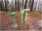
 | Preval - Jeterbenk
Jeterbenk is a 774 m high peak located between Slavko's home at Gole Brdo and Katarina (Topol village). From the top, where there is a large cros...
2 h 5 min |
 | Vrzdenec - Koreno (via Samotorica)
Koreno also Koreno is a 729 m high hill located north of Horjul. From the top, where there is a large cross, the Church of St. Mohorj and Fortuna...
1 h 45 min |
 | Kandrše (Trata) - Limbarska gora
Limbarska gora is located north-east of Moravce. From the top there is a beautiful view of the surrounding peaks and in good weather you can also...
3 h 15 min |
 | Žiri - Vrh Svetih Treh Kraljev
The Church of the Holy Three Kings is situated on a lookout above the village of Vrh Svetih Treh kraljev. From the top, which has an observation ...
2 h 30 min |
 | Veliko Trebeljevo - Janče
Janče is a 792-metre-high peak located between the Sava River and the valley of the Besnica Stream. From the top, where the mountain lodge stands...
2 h 15 min |
 | Sveta Trojica - Cicelj
Cicelj is a forested peak located between Moravče and the village of Senožeti. There is no view from the top, which has a bench and a registratio...
1 h 45 min |
 | Zaplana (Prezid) - Ulovka
Ulovka is the peak between Zaplana and the Shelter at Mountain pasture above Vrhnika. From the top, which is reached by ski lifts, there is a nic...
1 h 45 min |
 | Katarija - Slivna (Pivkelj)
Slivna or Pivkelj (also Pivkelj turn) as this peak is also called is located south of Limbarska Gora. Pivkelj is also the highest point of the Mo...
1 h 55 min |
 | Moravče - Slivna (Pivkelj)
Slivna or Pivkelj (also Pivkelj turn) as this peak is also called is located south of Limbarska Gora. Pivkelj is also the highest point of the Mo...
2 h 30 min |
| Kandrše (Trata) - Slivna (Pivkelj) (via Sveti Florjan)
Slivna or Pivkelj (also Pivkelj turn) as this peak is also called is located south of Limbarska Gora. Pivkelj is also the highest point of the Mo...
2 h 20 min |
| Kandrše (Trata) - Slivna (Pivkelj) (via GEOSS)
Slivna or Pivkelj (also Pivkelj turn) as this peak is also called is located south of Limbarska Gora. Pivkelj is also the highest point of the Mo...
2 h |
 | Col - Sinji vrh (west path)
Sinji vrh is a scenic mountain located between Col, Ajdovščina and Predmeja. From the top, you can enjoy a beautiful view over most of western Sl...
3 h 10 min |
 | Trpčane - Koča na Kozleku
The hut is located south-west of Ilirska Bistrica, just a few metres below the top of Kozlek. From the top, the view is only to the south and wes...
1 h 45 min |
 | Ledinica - Sivka
Sivka is a forested peak located west of Žiri and north of Idrija. On the summit there is a stamp of the Slovenian mountain trail and a registrat...
1 h 50 min |
| Sovodenj - Sivka
Sivka is a forested peak located west of Žiri and north of Idrija. On the summit there is a stamp of the Slovenian mountain trail and a registrat...
2 h |
 | Brzika - Donačka gora
Donačka gora is a peak located north of Rogatec. The peak, which geographically belongs to Karawanks, offers a beautiful view of the surrounding ...
1 h 45 min |
 | Črešnjice - Stolpnik (Črešnjice - Stolpnik - Sojek)
At 1012 m, Stolpnik is the highest peak of the Konjiška Gora, a mountain range stretching south-west from Slovenske Konjice. A 25 m high lookout ...
2 h 30 min |
 | Planina pri Sevnici - Skalica (Bohor) (via hunting lodge Bohor)
Skalica is a less known peak in the western part of Bohor. From the summit, which has a registration box, there is a beautiful view to the south ...
2 h |
 | Planina pri Sevnici - Koprivnik (Bohor)
Koprivnik or Veliki Koprivnik is one of the many peaks in Bohor. It is located between Koča na Bohorju and Veliki Koprivnik. From the top of the ...
2 h |
 | Lašče - Sveti Peter
Sveti Peter is a partially vegetated peak in the Dry Krajina above the village of Dvor. On the top there is a small shelter (usually open on Sund...
1 h 45 min |
 | Preval - Rog
The Rog is a 798 m high peak located above the village of Topole, just 10 minutes from St Catherine's Church. From the top of the hill, where a l...
1 h 55 min |
 | Velike Lašče - Kamen vrh (čez Gornje Retje in Grmado)
Kamen vrh is a scenic peak located on the northern outskirts of Mala Gora. From the top, surrounded by low bushes, there is a beautiful view of p...
2 h 35 min |
 | Dule - Grmada on Mala gora
Grmada (also Grmada nad Ortnek) is an 887 m high peak located above the village of Vrh pri Poljanah in the Mala Gora mountain range. Just a few m...
2 h |
 | Velike Lašče - Grmada on Mala gora (čez Gornje Retje)
Grmada (also Grmada nad Ortnek) is an 887 m high peak located above the village of Vrh pri Poljanah in the Mala Gora mountain range. Just a few m...
2 h |
| Velike Lašče - Grmada on Mala gora (čez Kamen vrh)
Grmada (also Grmada nad Ortnek) is an 887 m high peak located above the village of Vrh pri Poljanah in the Mala Gora mountain range. Just a few m...
2 h |
 | Ortnek - Stene svete Ane
Stene svete Ane is a vegetated peak located near the mountain hut at Sveti Anna on Mali gora. A small observation tower stands on the summit, whi...
2 h 30 min |
 | Ernejčkov graben - Sivka
Sivka is a grassy peak located in the westernmost part of the Polhograje Hills. In good weather, the peak offers a magnificent view from Snežnik ...
2 h |
 | Ljubljanica - Sivka
Sivka is a grassy peak located in the westernmost part of the Polhograje Hills. In good weather, the peak offers a magnificent view from Snežnik ...
2 h 25 min |
 | Kočevje - Livoldski vrh (Grajska way)
Livoldski vrh is a forested peak located in the south-eastern part of Stojna. The summit has a registration box and a stamp....
1 h 45 min |
 | Pristavlja vas - Pristava above Stična
Pristava above Stična is a small village located on a scenic hill north of Stična. A little above the village, by the Partisan House, there is a ...
1 h 45 min |
 | Dom pod Reško planino - Sveta planina (Partizanski vrh)
Sveta planina, also Partizanski vrh, is a 1011 m high mountain located between Čemšeniška mountain pasture and Mrzlica. From the top, where a sma...
2 h 5 min |
 | Jezersko polje - Rudnica
Rudnica is a scenic mountain located between the Lower and Upper Bohinj Valley. From the top, where there is a registration box with a stamp and ...
1 h 45 min |
 | Zavrh pri Trojanah - Golčaj
Golčaj is a 690 m high hill rising south of Blagovica. On the top, which has a registration box and a stamp, stands the NOB monument, and a few 1...
2 h 30 min |
 | Trojane - Špilk
Špilk is a 956 m high peak located north of Blagovica. On the summit, which is mostly forested, PD Blagovica has built a small bivouac with a ben...
2 h 30 min |
 | Trojane - Špilk (past the cross Na Kočni)
Špilk is a 956 m high peak located north of Blagovica. On the summit, which is mostly forested, PD Blagovica has built a small bivouac with a ben...
2 h 15 min |
 | Mislinja - Fričev vrh (via Završe)
Fričev vrh is an 881 m high hill located south of Mislinja Dobrava. There is no view from the top, which has a registration box with a registrati...
2 h |
 | Zazid - Golič (via Lipnik)
Golič is a grassy ridge stretching from Kojnik to the Slovenian-Croatian border and continuing to Žbevnica on the Croatian side. Due to the relat...
2 h 30 min |
 | Podgorje - Golič (via hunting cottage)
Golič is a grassy ridge stretching from Kojnik to the Slovenian-Croatian border and continuing to Žbevnica on the Croatian side. Due to the relat...
2 h 40 min |
 | Sovodenj - Štor (razgledna pot)
Štor is a 1005 m high peak located directly above the Ermanovec Cottage. The peak itself is covered with forest, but from the meadow, which is on...
1 h 45 min |
| Dolenji Novaki (Pod Kovkom) - Štor
Štor is a 1005 m high peak located directly above the Ermanovec Cottage. The peak itself is covered with forest, but from the meadow, which is on...
3 h |
 | Zgornja Besnica (Podrovnik) - Sveti Mohor (Zabrekve)
The Church of St. Mohor is situated on a 952 m high hill, between Zgornja Besnica and Selce. From the church, or its immediate surroundings, we h...
1 h 45 min |
 | Zazid - Kavčič (via Lipnik)
Kavčič is a grassy peak located above the village of Rakitovec on the Slovenian Croatian border. From the top, where there are two crosses and a ...
2 h 30 min |
 | Zazid - Nadglavinjak (via Lipnik)
Nadglavinjak is a lesser known peak located southeast of Golič. From the unmarked and grassy peak, we have a beautiful view of Slavnik, Čičarija,...
2 h 10 min |
 | Sveti Mavricij - Sveti Socerb (Artviže)
The Church of St. Socerbo is situated on a hill overloking the village of Artviže, which is the highest peak in Brkina with its 817 m. The church...
2 h 15 min |
 | Kopačnica - Veliki vrh (Lajše)
Veliki vrh is an almost 900 m high peak rising south of Cerkno. From the top, where there are several television and radio transmitters covering ...
2 h 50 min |
 | Sovodenj - Škofje (through Miklavževa grapa)
Škofje is a 973 m high peak located above the villages of Čeplez, Planina pri Cerknem and Podpleče. The peak itself, on which stands a small conc...
2 h 55 min |
| Sovodenj - Škofje (razgledna pot)
Škofje is a 973 m high peak located above the villages of Čeplez, Planina pri Cerknem and Podpleče. The peak itself, on which stands a small conc...
3 h 15 min |
| Dolenji Novaki (Pod Kovkom) - Škofje
Škofje is a 973 m high peak located above the villages of Čeplez, Planina pri Cerknem and Podpleče. The peak itself, on which stands a small conc...
2 h |
 | Sovodenj - Loncmanova Sivka (Mrzli Vrh)
Loncmanova Sivka is a scenic peak located above the village of Mrzli Vrh above Žirmi. From the uncultivated peak, in good weather, we can enjoy v...
2 h |
 | Vinska Gora - Ramšakov vrh (easy path)
Ramšakov vrh is the highest point of the circular route around Vinská Gora. On the 970 m high summit, besides the bench, there is a registration ...
2 h |
 | Vinska Gora - Ramšakov vrh (via farm Vodošek)
Ramšakov vrh is the highest point of the circular route around Vinská Gora. On the 970 m high summit, besides the bench, there is a registration ...
2 h |
 | Krače - Pleše
Pleše is an 866 m high peak located between the Marela Ski Resort and Zasavska Sveta Gora. From the top, where the NOB monument is located, you h...
1 h 45 min |
 | Tržič - Veliki vrh above Završnik (via Kamnek)
Veliki vrh above Završnik is a 968 m high mountain located in the Pirmance ridge, north to north-east of Tržič. From the grassy summit, where the...
1 h 45 min |
 | Greuth - Große Muschenig (via Maria Elender Alm)
Große Muschenig, or after German. Große Muschenig is a 1021-metre-high peak located on the Austrian side of Karawanks, more precisely between the...
1 h 45 min |
| Greuth - Große Muschenig (via Hasengraben)
Große Muschenig, or after German. Große Muschenig is a 1021-metre-high peak located on the Austrian side of Karawanks, more precisely between the...
1 h 45 min |
 | Gorenja vas - Javorč (via Jermanca)
Javorč is a 901-metre-high peak located to the north-east of Žiri. The summit, where the registration box with the registration book is located, ...
2 h |
 | Planina pri Sevnici - Debeli vrh (Bohor)
Debeli vrh is a 921-metre-high peak on Bohor between Veliki Koprivnik and Oslice. It is overgrown with dense forest, so there are no views. There...
2 h 30 min |
 | Planina pri Sevnici - Brest (Bohor) (via Škofov travnik)
Brest is a peak on Bohor although it loks more like a saddle. It is an important intersection of the Bohor trails. It lies between Oslica, which ...
2 h 35 min |
| Planina pri Sevnici - Brest (Bohor) (northern path)
Brest is a peak on Bohor although it loks more like a saddle. It is an important intersection of the Bohor trails. It lies between Oslica, which ...
2 h 20 min |
 | Brzika - Plešivec (pri Boču)
Peace, silence, rugged terrain... the characteristics of a peak at the "crossroads" of many routes between the Maribor, Celje and Ptuj areas. Ple...
2 h 15 min |
 | Lovrenc na Pohorju - Hlebov vrh (Rdeči Breg)
The Red Bank stretches between the Radoljna Gorge in the east, the Drava River in the north and the Velka Stream in the east. It is separated fro...
2 h 10 min |
 | Lovrenc na Pohorju - Hlebov vrh (Rdeči Breg) (via Povh and Brabar)
The Red Bank stretches between the Radoljna Gorge in the east, the Drava River in the north and the Velka Stream in the east. It is separated fro...
2 h 30 min |
| Lovrenc na Pohorju - Hlebov vrh (Rdeči Breg) (via Kapus)
The Red Bank stretches between the Radoljna Gorge in the east, the Drava River in the north and the Velka Stream in the east. It is separated fro...
2 h 40 min |
 | Col - Podrta gora above Ajdovščina
Podrta gora above Ajdovščina, also called the Broke Mountain above Šturje, is a mountain rising above the Vipava valley. Some time ago, a large c...
1 h 45 min |
 | 18th hairpin turn of road on Strma Reber - Loška stena
Loška stena is located above the Upper Kolpa Valley, specifically above the villages of Grintovec pri Osilnici, Ložec and Ribjek. From the top of...
2 h 25 min |
 | Terme Topolšica - Lomek (Lom)
Lom, with its highest peak Lomek (884 m), is an peak of karst origin, located above the tourist and health resort of Topolšica. From the top, you...
1 h 50 min |
 | Paka pri Velenju - Visoko
Visoko is an easily accessible grassy plateau located south of Paško Kozjak. On the top stands a monument to the fallen fighters of the 14th NOV ...
1 h 45 min |
 | Ledinica - Planinska koča Mrzl'k
Planinska koča Mrzl'k is located just a few metres below the summit of Mrzlik. The hut offers a beautiful view of the neighbouring Mrzli vrh (Lon...
1 h 45 min |
| Žiri - Planinska koča Mrzl'k
Planinska koča Mrzl'k is located just a few metres below the summit of Mrzlik. The hut offers a beautiful view of the neighbouring Mrzli vrh (Lon...
2 h |
 | Ledinica - Planinska koča Mrzl'k (via Jarčja Dolina)
Planinska koča Mrzl'k is located just a few metres below the summit of Mrzlik. The hut offers a beautiful view of the neighbouring Mrzli vrh (Lon...
1 h 45 min |
 | Radeljski prelaz - Sveti Pankracij (Radelca) (Austrian path)
The Church of St Pancras on Radelca is located on the border ridge between Slovenia and Austria, but since 1966, following an inter-state agreeme...
3 h |
| Radeljski prelaz - Sveti Pankracij (Radelca) (via Sveti Urban)
The Church of St Pancras on Radelca is located on the border ridge between Slovenia and Austria, but since 1966, following an inter-state agreeme...
3 h 15 min |
 | Radlje ob Dravi - Sveti Anton na MP Radelj / St. Anton am Radlpaß (via old castle)
The Church of St Anton at Border crossing Radelj / St Anton am Radlpaß is located on the Austrian side of the Kozjak Mountains, on a 720-metre-hi...
2 h 15 min |
 | Trebija - Vrhovski grič (via Sveti Pavel)
Vrhovski grič is a scenic hill located along the marked Trebija - Ermanovec trail. The grassy summit offers a beautiful view of the surrounding h...
1 h 45 min |
 | Lovrenc na Pohorju - Klančnik (Glančnik) (via Kapus)
Klančnik, also known as Glančnik on some maps, is an 877-metre-high peak located above the right bank of the Drava River, just a few minutes away...
2 h |
 | Lovrenc na Pohorju - Klančnik (Glančnik) (via Povh, Brabar and Hudej)
Klančnik, also known as Glančnik on some maps, is an 877-metre-high peak located above the right bank of the Drava River, just a few minutes away...
2 h 25 min |
| Janževski Vrh (Uran) - Klančnik (Glančnik) (via Sveti Ignacij)
Klančnik, also known as Glančnik on some maps, is an 877-metre-high peak located above the right bank of the Drava River, just a few minutes away...
2 h |
 | Deutschfeistritz - Schartnerkogel (on road)
Schartnerkogel is a 931m high hill above the town of Deutschfeistritz (German Bistritz) in the western part of the Graz mountain range. A cross s...
2 h |
 | Prelaz Vrhe - Maceljska gora (via source of Sotla)
...
1 h 50 min |