 | Koča pri Savici - Kanjavec (via Triglavska jezera)
Kanjavec is a 2,569-meter-high mountain located between Dolič and Hribarice. From the summit, which has a logbook box and a stamp, a beautiful vi...
6 h 30 min |
 | Sele-Zvrhnji Kot (Male) / Zell-Oberwinkel (Male) - Loibler Baba/Košutica (over Hajnževo sedlo)
Košutica (also known as Ljubeljska Baba) is a panoramic mountain north of the western ridge of Košuta. From the summit, marked by a small cross a...
4 h 15 min |
 | Na Razpotju - Planjava
Planjava is a smaller mountain group east of Kamniško sedlo. It has two peaks eastern and western. The marked path leads to the eastern peak, wh...
5 h |
 | Mače - Storžič
Storžič is a 2132 m high mountain located in the western part of the Kamnik-Savinja Alps. From the summit, where there is a cross, a beautiful vi...
4 h |
 | Križe - Storžič (via Psica)
Storžič is a 2132 m high mountain located in the western part of the Kamnik-Savinja Alps. From the summit, where there is a cross, a beautiful vi...
6 h |
| Laško - Storžič (via Sveti Lovrenc and over Bašeljski preval)
Storžič is a 2132 m high mountain located in the western part of the Kamnik-Savinja Alps. From the summit, where there is a cross, a beautiful vi...
4 h 30 min |
| Bašelj - Storžič (via Sveti Lovrenc and over Bašeljski preval)
Storžič is a 2132 m high mountain located in the western part of the Kamnik-Savinja Alps. From the summit, where there is a cross, a beautiful vi...
5 h 5 min |
| Bašelj - Storžič
Storžič is a 2132 m high mountain located in the western part of the Kamnik-Savinja Alps. From the summit, where there is a cross, a beautiful vi...
4 h |
| Bašelj - Storžič (via hospital Košuta)
Storžič is a 2132 m high mountain located in the western part of the Kamnik-Savinja Alps. From the summit, where there is a cross, a beautiful vi...
4 h 10 min |
| Spodnja Kokra - Storžič
Storžič is a 2132 m high mountain located in the western part of the Kamnik-Savinja Alps. From the summit, where there is a cross, a beautiful vi...
5 h 45 min |
| MHE Zabukovec - Storžič (via Bašeljski preval)
Storžič is a 2132 m high mountain located in the western part of the Kamnik-Savinja Alps. From the summit, where there is a cross, a beautiful vi...
4 h |
 | Dom v Kamniški Bistrici - Brana
Brana is a mountain above Kamniško sedlo. From the spacious summit, which has a registration box and a small cross, there is a very beautiful vie...
5 h |
 | Belca - Mittagskogel/Kepa
Kepa (also Jepa, German: Mittagskogel) is a panoramic mountain in the western Karavanke, located on the border ridge between Slovenia and Austria...
4 h 15 min |
 | Podrožca / Rosenbach - Mittagskogel/Kepa
Kepa (also Jepa, German: Mittagskogel) is a panoramic mountain in the western Karavanke, located on the border ridge between Slovenia and Austria...
5 h 10 min |
| Čemernica / Tschemernitzen - Mittagskogel/Kepa
Kepa (also Jepa, German: Mittagskogel) is a panoramic mountain in the western Karavanke, located on the border ridge between Slovenia and Austria...
5 h 5 min |
 | Na Razpotju - Ojstrica (via Škarje)
Ojstrica, named for its sharp shape, rises steeply above Korošica, the Logarska Dolina valley, and Robanov Kot. From the summit, which has a regi...
4 h 15 min |
 | Pred Belo - Ojstrica
Ojstrica, named for its sharp shape, rises steeply above Korošica, the Logarska Dolina valley, and Robanov Kot. From the summit, which has a regi...
6 h 45 min |
 | Robanov kot - Ojstrica (via Mala Ojstrica)
Ojstrica, named for its sharp shape, rises steeply above Korošica, the Logarska Dolina valley, and Robanov Kot. From the summit, which has a regi...
5 h 15 min |
 | Pred Belo - Ojstrica
Ojstrica, named for its sharp shape, rises steeply above Korošica, the Logarska Dolina valley, and Robanov Kot. From the summit, which has a regi...
6 h 45 min |
| Robanov kot - Ojstrica (via Kocbekov dom)
Ojstrica, named for its sharp shape, rises steeply above Korošica, the Logarska Dolina valley, and Robanov Kot. From the summit, which has a regi...
5 h 45 min |
 | Koča pri Savici - Mala Tičarica
Mala Tičarica is a highly panoramic mountain above the Twin Triglav Lakes. From the summit there is a beautiful view toward the Koča pri Triglavs...
4 h 10 min |
 | Koča pri Savici - Tolminski Kuk (via Vrh Planje)
Tolminski Kuk is the highest peak in the Bohinj-Tolmin mountains. The summit, equipped with a registration box, offers a very beautiful view. Fro...
6 h |
 | Koča pri Savici - Zasavska koča na Prehodavcih
The Zasavska koča na Prehodavcih mountain hut is located on a panoramic rise above the Valley of the Triglav Lakes. From the hut, open in the sum...
5 h 10 min |
 | Možnica - Jerebica
Jerebica is a mountain located on the border between Slovenia and Italy, between the Možnica and Jezerska valleys. From the summit, where there i...
5 h |
 | Koča pri Savici - Veliko Špičje
Veliko Špičje is the highest peak in the ridge from Travnik to Zasavska koča. From the top, there is a very nice view of the Komna plateaus, the ...
5 h 40 min |
| Trenta - Veliko Špičje
Veliko Špičje is the highest peak in the ridge from Travnik to Zasavska koča. From the top, there is a very nice view of the Komna plateaus, the ...
6 h 30 min |
 | Koča pri Savici - Mala Zelnarica (via Štapce)
Mala Zelnarica is a 2310-meter-high peak situated between the Valley of the Triglav Lakes and the Za Kopico Valley. From the summit, which has a ...
5 h 55 min |
 | Koča pri Savici - Mala Zelnarica (via Vrata)
Mala Zelnarica is a 2310-meter-high peak situated between the Valley of the Triglav Lakes and the Za Kopico Valley. From the summit, which has a ...
6 h 40 min |
 | Valbruna - Jof di Miezegnot/Poldašnja špica (via Planina Ravne)
Poldašnja špica is the easternmost two-thousander in the Malborghetto mountains group (Monti di Malborgheto). From the mountain, which has many r...
3 h 45 min |
| Valbruna - Jof di Miezegnot/Poldašnja špica (via Planina Strehica)
Poldašnja špica is the easternmost two-thousander in the Malborghetto mountains group (Monti di Malborgheto). From the mountain, which has many r...
4 h |
 | Malborghetto - Jof di Miezegnot/Poldašnja špica
Poldašnja špica is the easternmost two-thousander in the Malborghetto mountains group (Monti di Malborgheto). From the mountain, which has many r...
4 h |
 | Bagni di Lusnizza - Cima Alta (Due Pizzi)
Dve špici (Due Pizzi) comprise two peaks in the Naborjet mountains group, namely Cima Alta (2046 m) and Cima Vildiver (2008 m). Both peaks have a...
4 h |
| Malborghetto - Cima Alta (Due Pizzi) (path 605)
Dve špici (Due Pizzi) comprise two peaks in the Naborjet mountains group, namely Cima Alta (2046 m) and Cima Vildiver (2008 m). Both peaks have a...
4 h 25 min |
 | Ovčja vas / Valbruna - Kamniti lovec / Cima del Cacciatore
Kamniti lovec is a popular excursion point above Trbiž. Due to the short approach, shortened by the cable car to Višarje, it is well visited. Two...
4 h |
 | Soča - Bavški Grintavec
Bavški Grintavec is a mighty mountain rising steeply above the Bavšica, Zadnja Trenta, and Soča valleys. All approaches to the summit are long, a...
5 h 30 min |
 | Na Razpotju - Krofička (marked way)
Krofička (or Grofička according to some records) is a peak located northeast of Ojstrica. From the summit, which steeply descends towards Logarsk...
3 h 40 min |
 | Reklanska dolina - Sart / Žrd
Žrd, or Monte Sart in Italian, is a panoramic mountain located on the northwestern ridge of the Kanin mountains. The summit, which has a logbook ...
5 h 15 min |
 | Solbica / Stolvizza - Sart / Žrd (via Ricovero Igor Crasso)
Žrd, or Monte Sart in Italian, is a panoramic mountain located on the northwestern ridge of the Kanin mountains. The summit, which has a logbook ...
6 h |
 | Unterpirkach - Hochstadel (Dreitörlweg)
Hochstadel is a 2,681-meter peak in the eastern part of the picturesque Lienz Dolomites. From the summit, where a large cross commemorates those ...
6 h 50 min |
 | Hinterstoder - Großer Priel
Großer Priel, at 2515 meters, is the highest peak in the Totes Gebirge mountain group. From the summit, where a large red cross stands, there is ...
5 h 15 min |
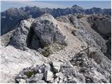
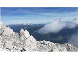
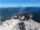 | Parking Alpspitzbahn - Alpspitze (Ostgrat)
Alpspitze is a 2628-meter-high peak in the Wetterstein mountain group. From the summit, where a cross from 1946 stands, there is a very nice view...
6 h 15 min |
 | Parking Alpspitzbahn - Bernadeinkopf (via Osterfelderkopf)
Bernadeinkopf is a 2143-meter-high peak in the Wetterstein mountain group. From the summit, where a cross stands, there is a very nice view of th...
5 h 30 min |
 | Val Aupa - Sernio (via normale)
Sernio (Ital. Monte Sernio / Furlan: Serenât or Crete di Seregnò) is a 2,187 m high mountain in the Carnic Alps in Italy, between the Aupa river ...
4 h 30 min |