Na Razpotju - Krofička (marked way)
Starting point: Na Razpotju (770 m)
| Latitude/Longitude: | 46,392°N 14,6273°E |
| |
Route name: marked way
Walking time: 3 h 40 min
Difficulty: difficult marked way
Elevation gain: 1313 m
Elevation difference along the route: 1313 m
Map: Kamniške in Savinjske Alpe 1:50.000
Recommended equipment (summer): helmet
Recommended equipment (winter): helmet, ice axe, crampons
Views: 82.627
 | 3 people like this post |
Access to starting point:
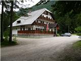
We drive to Luče (to here from Mozirje or over Kranjski rak) and continue towards Logarska dolina. Soon after the village Solčava we come to the crossroads, where the road to Logarska dolina branches off to the left. We turn left towards Logarska dolina (toll payment) and drive on the road to the signs for the mountain hut at Klemenča jama. We park on the parking lot near the guesthouse Na Razpotju. In front of the guesthouse parking is allowed only for guests.
Route description:
From the parking lot, we head onto the forest road in the direction of Klemenča jama. After a few minutes of walking, a wide path branches off to the left towards Klemenča jama. We take this path, which starts to ascend. A quite steep path soon brings us to steep slopes, where with the help of a steel cable we cross a slightly exposed gully. The path, which continues ascending, soon brings us to the spot where a wall blocks the path. In front of us we see a cave and above it a marking that directs us into the cave. When we step into the cave, we see that it is not a cave, but a nicely made tunnel through which we continue. In the tunnel, a steel cable assists us, which we need more on the descent than on the ascent. On the other side, along a wide path in a gentle ascent, we cross an exposed ledge. The path ahead goes into the forest and continues ascending steep slopes that are dangerous for slipping when wet. Ahead, over a small bridge, we cross another gully, then the path brings us to a less steep section, where the path from Dom Planincev joins. We continue slightly upwards along a wide path that soon takes us out of the forest. Only a short ascent on a grassy slope to the mountain hut Koča na Klemenči jami follows.
From the hut, we continue left in the direction of Krofička and Strelovec along the path that goes into the forest and after 10 minutes of moderate ascent brings us to the larch whose circumference at 130 cm height is 464 cm, and diameter 147 cm. At the larch, the marked path turns left and shortly ahead crosses a clearing that is full of flowers in summer. Ahead, the path goes into the forest and ascends along a nicely made path that after one hour of walking from the hut brings us to the next junction. We continue straight in the direction of Krofička (left Strelovec) along the path that slowly turns somewhat more to the right. The path then gradually transitions from the forest to bush-covered slopes that become steeper meter by meter. When the last larches disappear from the path, we reach technically more demanding sections. A well-secured path first leads over short wooden steps, after which with the help of a steel cable we ascend a gravelly slope that soon brings us to a gully exposed to falling rocks (helmet). We ascend steeply through the gully with the help of a steel cable, then turn left and continue along a slightly exposed ledge that quickly brings us to the last steep part of the path. Ahead, with the help of pegs in a few minutes, we ascend to the summit of Krofička.
Na Razpotju - Klemenča jama 1:10, Klemenča jama - Krofička 2:30.

The trip can be extended to the following destinations: Matkov kot
Photos:
 1
1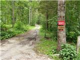 2
2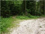 3
3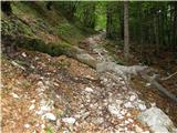 4
4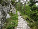 5
5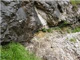 6
6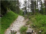 7
7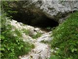 8
8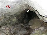 9
9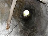 10
10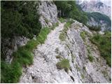 11
11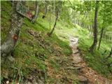 12
12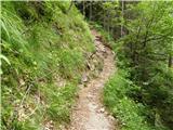 13
13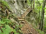 14
14 15
15 16
16 17
17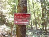 18
18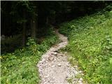 19
19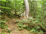 20
20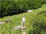 21
21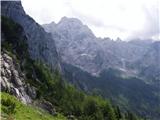 22
22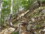 23
23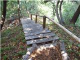 24
24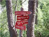 25
25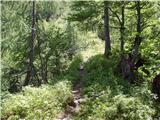 26
26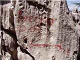 27
27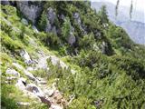 28
28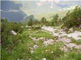 29
29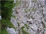 30
30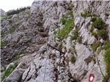 31
31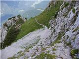 32
32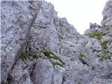 33
33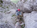 34
34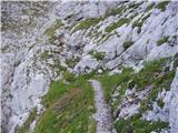 35
35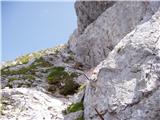 36
36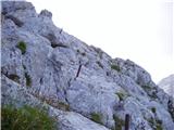 37
37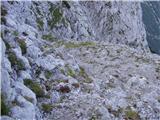 38
38 39
39
Discussion about the trip Na Razpotju - Krofička (marked way)
Show older messages
|
| klavdipo20. 07. 2008 |
Today I did this tour and it's really super. It's a fairly little-visited mountain, the path is good and nicely secured plus exceptional view from the top especially on Robanov kot and the north face of Ojstrica. I recommend it to all mountain gourmets!
|
|
|
|
| bobo24. 09. 2008 |
on Saturday 27.9. I plan to go to the summit. does anyone have any info about the path? any snow on the path, maybe some other danger on the path?
best regards,
|
|
|
|
| canislupus26. 09. 2008 |
why not call the hut? They would give you suitable information.
best regards, gornica
|
|
|
|
| damijanp2. 10. 2008 |
On Tuesday, 30.9., I set off from the House of Mountaineers to Krofička. At about 1800m, the first snow patches appear (the northern side of Ojstrica has snow even lower, as the sun practically doesn't shine on it during the day).
Snow on the path towards the summit
Beautiful view of the surrounding peaks
A little below the summit, right below the top of the gully, it was quite icy, so I preferred to turn back.
Below the summit
I completed the trip with a visit to Strelovec, where the sun was pleasantly shining.
|
|
|
|
| bandy25. 05. 2009 |
Can someone tell me what the current conditions are like on the described path? Thanks
|
|
|
|
| rozka25. 05. 2009 |
A week ago it was still all covered in snow, the problem is only that the markers are under the snow and it's hard to hit the right path... otherwise I think there's no problem getting up with gear. Good luck!
|
|
|
|
| agopes6. 08. 2009 |
On Saturday I plan to go to Krofička.
What are the conditions like? Is there still any snow?
|
|
|
|
| geppo6. 08. 2009 |
You can visit this mountain without worry!
Best regards
|
|
|
|
| sergejom29. 10. 2009 |
Could someone hint if it's better to go up the marked path and down the hunting trail or vice versa? Or should I ask differently which one is more demanding?
|
|
|
|
| sergejom29. 10. 2009 |
Can someone tell me if it's better to go up the marked path and down the hunting path or vice versa? Or to put it differently, which one is more demanding?
|
|
|
|
| medo*29. 10. 2009 |
Both are steep and demanding - so if you know the path, it might still be possible to decide which one up and which one down. Otherwise, it might be better to first find the passages on the hunting path to the top.
|
|
|
|
| MatevžRebernak7. 06. 2010 |
Does anyone perhaps have any information about the condition of the trail?
Regards
|
|
|
|
| geppo8. 06. 2010 |
Probably a small snowfield awaits you just before the summit. It usually lingers there until mid-June.
|
|
|
|
| Lisa24. 06. 2010 |
Geppo, I know you'll be able to tell it well from first hand. What is the path to Krofička like for a hiker without experience.... Since I haven't been to Krofička myself, I don't know how suitable the path to Krofička is for a beginner. Please help...
Thanks and best regards.
|
|
|
|
| geppo24. 06. 2010 |
To be honest, I wouldn't recommend the path to Krofička to a hiker without experience. In the company of an experienced person yes (I'm rooting for myself... he, he) but alone no.
The path is demanding in the upper part and for a mountaineer with experience it's a normal high-altitude path, but for someone it can cause trouble. It's also more sparsely equipped with safety features (too much for some). The descent requires caution - risk of slipping!!
I hope I didn't take away all your morale. There are no other easier paths up!
So, in the company of an experienced person, go to this less-visited peak that will reward you with a magnificent view!!
Best regards
|
|
|
|
| Lisa24. 06. 2010 |
You wrote this great. Thank you. It's no problem for me, but on Saturday I'll take a young lady without experience with me, so I preferred to ask how suitable/not the path is.
Next time I'll go up in different company...
Thank you.
|
|
|
|
| hiter17. 10. 2010 |
Hello everyone. Next weekend I'm heading on this path. I'm curious about the conditions, is the path suitable for me since I have slight vertigo issues,... best
Is the hut still open?
|
|
|
|
| geppo17. 10. 2010 |
Conditions for such a date (next weekend) are hard to predict!
If you have vertigo issues I advise against this path. Find something more suitable to test yourself - for example Olševo.
|
|
|
|
| garmont17. 10. 2010 |
Given today's snowfall Krofička won't be the most suitable for visiting. The path is exposed in the upper part too, so vertigo sufferers better not tackle it alone. The hut at Klemenči jama is closed.
LP
|
|
|
|
| jvali12. 08. 2011 |
On Thursday, 11 August 2011, my friend and I conquered Krofička. I first, Mojca second. At the top, besides the sun, a quite severe cold and wind awaited us, so it was really very cold for a moment. The cables were also cold, which in two sections are in poor condition and need mandatory renovation. On the descent the sun warmed us again. We had a nice hiking day; and that day Krofička was a very visited lady.
|
|
|
|
| jvali12. 08. 2011 |
ups, I'm fast, every day I'm somewhere else in the mountains, so I wrote the wrong date on Krofička we were on Wednesday, 10.08.2011. on Krofička we were on Wednesday, 10.08.2011.
|
|
|
|
| viktor.zemljic5. 09. 2011 |
Finally back to the hills a bit:
On 30.08. three hikers went for the first time on this path to Krofička.
The weather wasn't the best for views of nearby peaks, but still nice and suitable for hiking in the hills. The path described above is picturesque and well-maintained and marked, and despite the relatively quick ascent, manageable for our conditions.
|
|
|
|
| _Abuh_30. 04. 2012 |
Has anyone been up there these days? What are the snow conditions like now?
|
|
|
|
| DavidK3. 06. 2012 |
I don't know about the exact snow conditions, but today from Strelovec it was visible that there is still quite a bit of snow towards the summit.
|
|
|
|
| robi145. 06. 2012 |
Does anyone have any data or photo about current conditions on the path to Krofička.
Otherwise Strelovec is more planned, but if the weather is good and path conditions fairly normal, maybe also Krofička summit.
lp
|
|
|
|
| Irina5. 06. 2012 |
@robi14,
on Saturday PD Pošte in Telekoma has a trip to Krofička. Ask the guide if he knows the conditions. He should know since he is leading the trip. That's what I think.
Guide/contact: Roman Tratar GSM: 041 387 801
|
|
|
|
| redbull6. 06. 2012 |
conditions worth it, if ok at 2500m then surely at Strelovec 1700m and others, same for Krofička
|
|
|
|
| scorpio782. 07. 2012 |
Yesterday we conquered the summit of Krofička. Great view and the weather was wonderful too. However, I must say that on the last (climbing) section the protection is already quite "worn out". The pegs on the cables are loosening and one needs to be quite careful. There could be one more peg on the last few meters to the top, it would really be welcome for the descent. Otherwise, an excellent achievement
|
|
|
|
| kapelj9. 07. 2012 |
can I go up alone without a guide 
|
|
|
|
| garmont9. 07. 2012 |
Is this a question or a statement? If it's a question, the answer is of course yes, provided you know how to walk on marked secured paths.
|
|
|
|
| damijanp28. 07. 2012 |
Indeed (as scorpio78 wrote) some safety gear is "tired", but care is needed on descent in the upper part because there's quite a bit of loose scree on the rocks.
Otherwise it's really a nice trip - lots of flowers, no crowds on the path.
Pictures at:
Krofička
|
|
|
|
| damijanp28. 07. 2012 |
Forgot to add that today protection against annoying flies/gnats would be necessary additional gear. There are really huge numbers of them at the top. We couldn't stay more than 5 minutes. 
|
|
|
|
| pabo27. 08. 2012 |
On 25. 8. was on the summit, the aids still "tired" , caution required, but the summit is unique, wonderful views of the surrounding peaks , caution required, but the summit is unique, wonderful views of the surrounding peaks
|
|
|
|
| anej16. 06. 2013 |
Yesterday we went on a hike towards Krofička. Towards the top there is still some snow. The problem is one steep scree slope which is snowy and has to be crossed, so I still recommend winter gear. Safe journey
|
|
|
|
| banana20138. 09. 2013 |
Today we were at Krofička. The path is well secured, only at one spot the peg is pulled out, but the cable holds. It's not at a critical point. Otherwise we think there were enough pegs, although we are not experienced hikers. It was quite cold and windy at the summit.
|
|
|
|
| banana20138. 09. 2013 |
Oh, and we almost missed the old larch, as it's to the right of the path further on from Klemenče jama and we didn't see any marker. On the way back we found it
|
|
|
|
| katja872. 11. 2013 |
On Thursday, 31.10.2013, we were at Krofička.
The day was quite changeable, so we were almost the whole time in fog, no views from the summit either.
The path in the upper part is well secured, only one peg is pulled out, but the wire rope still holds.
But when we were returning to the valley, the cloud cover decreased and we even had some views of the surrounding peaks
You can see photos from the hike on the website of the Matica Murska Sobota Mountaineering Association: http://www.mojalbum.com/pdmaticams/20131031-kroficka/smerokaz-na-parkiriscu/21227176
|
|
|
|
| borutpovse4. 05. 2014 |
Has anyone been up there recently? Current conditions, snow? Thanks for info, best regards
|
|
|
|
| geppo4. 05. 2014 |
There's still snow and equipment will be needed for quite some time.
best regards
|
|
|
|
| franjo6630. 06. 2014 |
Has anyone been up there recently? Current conditions, snow? Thanks for info, best regards
|
|
|
|
| Grenaleva12. 08. 2014 |
Yesterday walked the path with 12 and 13 year old children. The path in the morning is in the shade, the sun was at the top when we returned, shining nicely and offering beautiful views of Kamniško Savinjske alpe. The path is well laid out, just below the summit where the fixed cables begin, three are loose, so it's better to hold onto the rocks. No snow anywhere on the path anymore. From the junction with a 15-minute stop at Klemenča jama we walked exactly 3 hours and a half.
|
|
|
|
| črna murka18. 08. 2014 |
Yesterday walked the path. Really no snow anywhere on the path. To Klemenča jama several water options. Path is wet and quite slippery. Larch is hidden by fallen small spruce and easily missed. Path keepers could clean it a bit as sign is hidden too. Shame, worth seeing but many miss it now.
|
|
|
|
| dkrajnc2722. 10. 2015 |
Hi.
On Sunday we plan to visit this wonderful peak. I'm interested if we have any information on how much snow there is on it?
Thanks, good luck
|
|
|
|
| Grenaleva22. 10. 2015 |
Someone described the path to Korošica and back via the circular route through Deska a few days ago, mentioning a lot of snow. Given the final steep section, I really recommend good information.
|
|
|
|
| garmont22. 10. 2015 |
The marked path to Krofička runs along the northern side, which is already snowy. Winter gear is definitely needed for the current ascent, and there will also be difficulties finding the path in the snow.
Maybe go somewhere else instead...
|
|
|
|
| dkrajnc2724. 10. 2015 |
Thanks to both of you.
Gear is definitely there, as for the snow though, I agree there was plenty a few days ago, but it has largely melted away in these days. The path is chosen, the heart says it will go, if not, that's fine too, we'll turn back and enjoy anyway
Maybe someone else with some info who was there these days? Thanks, good luck
|
|
|
|
| dprapr24. 10. 2015 |
Krofička is still quite snowy. You'll get the photo by email.
The snow mostly sinks under boots, here and there it's hard, especially on the northern side. At least that's how it was today on Mrzla gora.
Definitely have gear with you. At this time there's nothing wrong if it's in the backpack.
|
|
|
|
| Hribolazec8123. 09. 2018 |
Today did the path, it's very nice up there.
At the summit there are lots of overgrown pitons that could be cleaned up a bit, at the hut very friendly staff, great atmosphere, all praise
|
|
|
|
| Toriasti17. 07. 2019 |
Hi! This weekend I'm heading to the mountains, one of the options is also Krofička. I'm wondering, since the path to the summit is more demanding, is access with a dog possible? The female dog is used to mountains, cautious, doesn't trigger rocks, agile and in proper condition. She has already hiked several summits with me, including Ledinski, Ojstrica (descent via Mala Ojstrica) - I had more trouble myself than she did, who mastered it perfectly.
Thanks in advance for all info and advice =)
|
|
|
|
| djimuzl17. 07. 2019 |
As can be seen from the path description, the most difficult part is a little below the summit, and for a dog it's passable without problems. The real problem could be elsewhere - in possibly triggering rocks in the mentioned gully, since I doubt the little dog can control its movement in that sense - unless it's small and thus light enough to only trigger a grain of sand
|
|
|
|
| zokipoki17. 07. 2019 |
I can't help it. Dogs are not for rocks, period! There are plenty of beautiful, long paths over and to the hills where the world is friendlier for little dogs! Krofička is not for dogs! My opinion. Best regards
|
|
|
|
| malimiha17. 07. 2019 |
If the dog is used to hiking in the mountains, Krofička poses no problem. Best regards
|
|
|
|
| Ani888. 08. 2019 |
Hello. Over the weekend, my partner and I plan to climb Krofička. I already have quite some experience (Triglav, Ojstrica, Mangart, Raduha, Peča, Olševa, ...), but my partner is more of a beginner in the mountains. He has been with me to Peča, Raduha and Olševa. Is that enough for the ascent to Krofička? One alternative is Brana, but I can't judge which mountain is more suitable. I'll be glad for any advice, as I don't want to bash my head against the wall. Regards.
|
|
|
|
| drdivx8. 08. 2019 |
I think there won't be a problem, since he was on Peča and Raduha. I hope on the climbing one.
On the marked path to Krofička, as far as I remember, there are only a few meters that are more "critical". That's 30-40 meters on the descent from the summit to the path. There are also, I think, two pitons there. In wet conditions, it could be a problem. Since it's been many years since my last ascent, I'm answering from memory.
Probably someone else will give you some useful advice too.
|
|
|
|
| garmont8. 08. 2019 |
The last 100 meters of elevation are overcome with the help of steel cables. Just below the summit, pitons help us. On the descent, you need to be careful, as there is quite a bit of scree underfoot, and the depth is not negligible. But it's not particularly difficult, and this section is really short.
|
|
|
|
| michael669. 08. 2019 |
Are those steel cables newer?
|
|
|
|
| zokipoki9. 08. 2019 |
michael66, as far as I know no.
|
|
|
|
| duncy1239. 08. 2019 |
This mountain is great to me, uncrowded and wonderful. My husband and I went up two years ago and the fixed cables were mostly unusable (torn in several places). Still, you can reach the summit normally, the only problematic part is the descent from the top as drdivx already mentioned. There are about 40 meters of exposed descent, if the partner is still insecure it can be a problem. (On Peca and Raduha they probably descended via the easy path)
Personally, I think the path to Brano is easier for beginners. Happy trails however you decide.
|
|
|
|
| ločanka12. 08. 2019 |
It's a great mountain for me too, in short wonderful, as duncy123 already said. The fixed cables are still somewhat torn, but that doesn't bother. Caution is needed in the upper part especially on the way back. Some people leave their poles a bit lower. At this time, the path is full of beautiful cushions of flowers, especially Zois' bellflowers and clustered saxifrages.
The path is very suitable for the current high temperatures, as it runs on the northern side, and if you start hiking in the morning, you step into the sun just below the summit. I was also surprised by the beautiful surroundings of the Koča na Klemenči jami hut. I could sit there and enjoy. In short, a tour that doesn't disappoint!
Helmet recommended, just in case.
|
|
|
|
| jprim12. 08. 2019 |
We roamed this area last year. At that time I didn't notice anything worth praising. Maybe something has changed, we'll have to check. I still maintain that our huts pay too little attention to the environment itself. Where is that nice sign I photographed a few years ago. It's gone, as the wood has become rotten.
Best regards!
|
|
|
|
| jprim13. 08. 2019 |
@ločanka
How can you write that torn cables don't bother. Maybe not you, but what about others who also want to the summit and don't have that much experience yet. When giving an opinion, it would be good to consider all hikers. Another trail that hasn't been maintained for a long time, and how catastrophic it is especially to Klemenče jama.
Best regards!
|
|
|
|
| garmont13. 08. 2019 |
Damaged cables and pulled-out pitons are on the section of the trail which can be nicely traversed even without using them. So...
|
|
|
|
| jaz13. 08. 2019 |
Jelica Primožič very negative, grumbler and eternal critic. When we have some action, I'll invite you to it... you'll carry pitons a bit, we'll see what you say then... Best!
|
|
|
|
| jprim14. 08. 2019 |
@ jaz
I really don't care how you think. I'm just a person who sees flaws too. I can also praise. You'll find that among my posts too.
You're a volunteer in your place, I'm one elsewhere.
|
|
|
|
| mapi6029. 06. 2020 |
Has anyone hiked this trail this year? I'm wondering if there's still any snow and on which sections, and what the condition of the protections is?
|
|
|
|
| garmont29. 06. 2020 |
Yes.
No snow, protections OK.
Check under the topic "Current conditions - Krofička".
|
|
|
|
| mapi6030. 06. 2020 |
garmont, have you already hiked the path through Žrelo to Storžič? Does it seem comparable time-wise to Krofička, or is Krofička longer? I'm asking because my friend and I did our last hike last year through Žrelo up and back via Škarjev rob, and for our hiking pace it was "just barely"...
|
|
|
|
| garmont30. 06. 2020 |
Yes. It's quite comparable time-wise.
Go boldly.
|
|
|
|
| mapi606. 07. 2020 |
yesterday I walked this path, the safety gear in the summit section is impeccable, but I would recommend a helmet in this section, because despite great care, some stone flies by accidentally. If it's a day like yesterday with excellent visibility, I must say the views are phenomenal....we saw hikers on Kopinškova path, on the top of Ojstrica, on Veliki vrh, one was on Križevnik...more than 1 hour of enjoyment on the summit!!
|
|
|
|
| Enka11. 08. 2021 19:59:55 |
Interesting and varied path, the steepness doesn't let up much (all 1300 meters of ascent on just 5.5 km). The fixed protections are in excellent condition and everywhere you need them, but on the descent it shows that Krofička is not to be trifled with, due to scree and loose rocks the upper few dozen meters require a steady step. Helmet highly recommended, as hikers diligently dislodge stones. But the path is really a great choice for hot days - yesterday start just before 8 a.m., and we had shade all the way to the top, which made the ascent much easier. The lower part of the path was quite shaded even on the descent, so I don't remember a more suitable path for summer outings.
|
|
|
|
| J.P.18. 07. 2022 20:45:52 |
Trail without special features. Below the summit, it's always worth putting on a helmet and being careful on the way back.
|
|
|
To post a comment you must log in:
If you do not yet have a username, you must first
register.