Robanov kot - Ojstrica (via Mala Ojstrica)
Starting point: Robanov kot (650 m)
| Latitude/Longitude: | 46,3948°N 14,703°E |
| |
Route name: via Mala Ojstrica
Walking time: 5 h 15 min
Difficulty: difficult marked way
Elevation gain: 1700 m
Elevation difference along the route: 1750 m
Map: Kamniške in Savinjske Alpe 1:50.000
Recommended equipment (summer): helmet
Recommended equipment (winter): helmet, ice axe, crampons
Views: 53.119
 | 3 people like this post |
Access to starting point:
Through the Volovljek pass (Kranjski Rak) or from Mozirje we drive to Luče, then we follow the signs for Solčava and Logarska dolina. When we arrive in the settlement Robanov Kot, signs for the alpine valley Robanov kot direct us to the left onto a side road, along which we drive to the parking lot near the farm Roban, where we park. We can also park already 500 meters lower, where there is another organized parking lot, but we must not park on the parking lot of the pension Govc-Vršnik, because consequently there is no space for the guests of the pension.
Route description:
If we've parked on the lower parking lot we continue on the road to the parking lot at the farm Roban, and only a few meters ahead from the last parking lot, we arrive at a crossroads, where we continue straight ahead on the road where there is a barrier (right Strelovec).
The road towards Robanova planina then goes into the forest and brings us to a junction, where we continue straight ahead, further on the road (left partisan hospital 45 min).
The road then brings us out of the forest onto Robanov travnik, where a nice view opens up on the surrounding mountain walls. On the other side of the meadow, the road goes back into the forest and ascends somewhat more steeply. This is followed by crossing a pasture fence and soon after we emerge from the forest onto the panoramic Robanova planina.
From the mountain pasture we continue following the signs »Korošica, Ojstrica« and a wide path brings us into the forest already after a few meters. After a short ascent the path turns left and crosses several torrent beds. We ascend again through the forest and soon arrive at a small waterfall below the slopes of Molička peč and Velika Zelenica. Here the path turns right and begins to ascend quite steep slopes with the aid of a steel cable and some pegs. This is followed by another short ascent through the forest on somewhat gentler slopes, after which we reach a somewhat more rocky section of the path. The path then ascends for quite some time on steep slopes above the torrent gully. The path here is routed through nice passages and is very well secured with a steel cable, so the ascent does not cause major difficulties. We are also assisted on the path by numerous pegs and steps carved into the rock. This is followed by a few more steeper ascents with the aid of the steel cable and pegs, after which the path brings us to gentle slopes covered with dwarf pines. The path then through the dwarf pines in a short descent brings us to a junction, where we continue straight in the direction of Korošica (right Molička planina 10 minutes). This is followed by a short ascent and we join the path from Planina Podvežak, which after a further short traversing ascent brings us to Sedelce.
From Sedelce we continue right in the direction of Ojstrica and Mala Ojstrica on a path that starts to ascend relatively steeply and after about 20 minutes brings us to the indistinct summit of Mala Ojstrica. Here the path turns left and ascends along and on the ridge, which is occasionally quite exposed. After a while the steepness of the slopes temporarily eases, and the path then brings us to the summit slopes of Ojstrica. Here the path, which is locally exposed and well secured at key points, starts to ascend more steeply. The increasingly panoramic path then brings us after an hour and a half of walking from Sedelce to the 2350 m high summit.
Robanov kot - Robanova planina 1:00, Robanova planina - Sedelce 2:45, Sedelce - Ojstrica 1:30.

Photos:
 1
1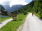 2
2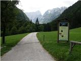 3
3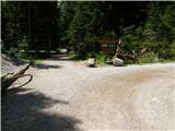 4
4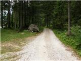 5
5 6
6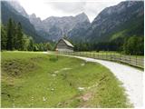 7
7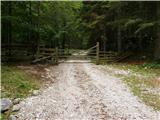 8
8 9
9 10
10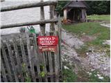 11
11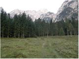 12
12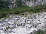 13
13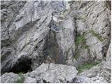 14
14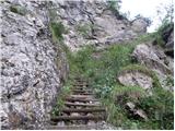 15
15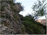 16
16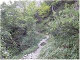 17
17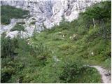 18
18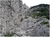 19
19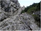 20
20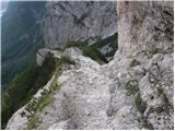 21
21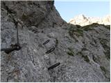 22
22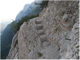 23
23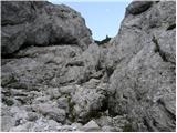 24
24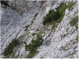 25
25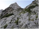 26
26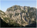 27
27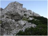 28
28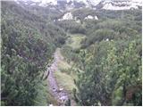 29
29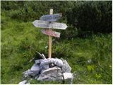 30
30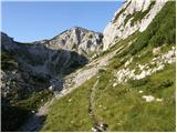 31
31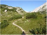 32
32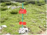 33
33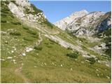 34
34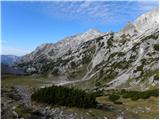 35
35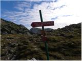 36
36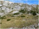 37
37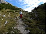 38
38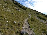 39
39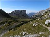 40
40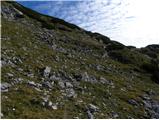 41
41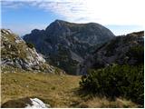 42
42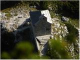 43
43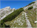 44
44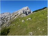 45
45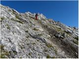 46
46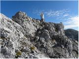 47
47 48
48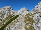 49
49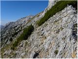 50
50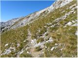 51
51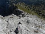 52
52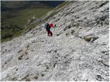 53
53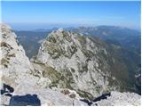 54
54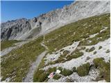 55
55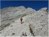 56
56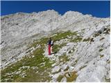 57
57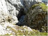 58
58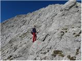 59
59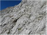 60
60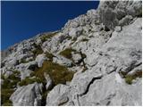 61
61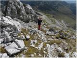 62
62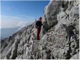 63
63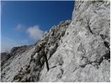 64
64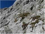 65
65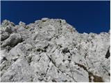 66
66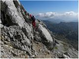 67
67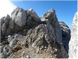 68
68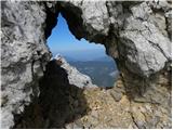 69
69 70
70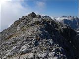 71
71 72
72
Discussion about the trip Robanov kot - Ojstrica (via Mala Ojstrica)
Show older messages
|
| Jacek8. 06. 2009 |
Is there any path from Robanov kot to Škarje and then along Kopinškova pot to Ojstrica?
|
|
|
|
| Jacek8. 06. 2009 |
Of course I meant Škrbina... 
|
|
|
|
| mosovnik9. 06. 2009 |
If you go from Roban to Škrbina between Krofička and Ojstrica, you don't go to Škarje (you'd have to descend and then under the walls of Ojstrica turn to the marked path to Škarje and further...) but at the saddle you join the marked Kopinškova, which by the way is quite demanding, especially in the upper part (watch for snowfield). From the top of Ojstrica you can return via Škarje to Klemenča jama and then choose a suitable direction back to R. kot and thus "close the loop".
Good luck.
|
|
|
|
| Jacek9. 06. 2009 |
Thanks for the reply, but I'm wondering if there's any trail from Robanov kot to Škrbina, or if it's pure pathless terrain. Any advice welcome. Has anyone tried from this side? Regards.
|
|
|
|
| geppo9. 06. 2009 |
You can reach it via the gully, but it's pure pathless terrain. No trail exists (at least I don't know of one). I don't recommend!!
Regards
|
|
|
|
| free9. 06. 2009 |
possible via Črni hriber - from Robanova planina to Krofička, then down to Škrbina? Description in Kamniško-Savinjske Alpe, Stritar, Sidarta.
|
|
|
|
| Jacek9. 06. 2009 |
Geppo, you wrote that you can get there via the gully, but what does that mean? Would I have to climb, do I need a rope, how long is that gully? And also: why don't you recommend this path?
|
|
|
|
| Jacek9. 06. 2009 |
Free, thanks for the suggestion. I've also studied this tour, but it's not the same as directly from Roban to Škrbina. This path tempts me though. Lp.
|
|
|
|
| geppo9. 06. 2009 |
Jacek, I don't recommend the path to you, because it would be irresponsible of me to advise you how to get to Škrbina!
Already from the question you asked and "mosovnik" answered, it's clear that the question is completely wrongly posed.
( Is there a path from Robanov kot to Škarje and then along Kopinškova pot to Ojstrica? )
Jacek, go from Klemenče to Škrbina and then via Kopinškova to the top of Ojstrica. You can nicely see the approaches from Roban to Škrbina and decide.
Attention!!
"mosovnik" has already warned about the snowfield a little below the summit (north side); winter gear will still be needed there for some time!!
Lp
|
|
|
|
| Jacek9. 06. 2009 |
Geppo, okay. Thanks for the friendly advice. I know Kopinškova pot, other paths too. I thought there was some easy access from Roban, because from that side it would really be interesting to climb up. I'll think about it some more. Thanks again. Lp.
|
|
|
|
| geppo9. 06. 2009 |
Easy one - unfortunately I don't know any!! I didn't use the gully for this crossing to Škrbina - but a buddy did and then I'll give you the info as I got it from him!
We plan to repeat Ute after many years - I'll also take a closer look at this variant, which is interesting. In my assessment when looking from Škrbina to Roban (already several times) it's not easy!!
Lp
|
|
|
|
| Jacek9. 06. 2009 |
Thanks again. Also for the concern. And I would really appreciate the details. Lp.
|
|
|
|
| mosovnik10. 06. 2009 |
Jacek, you're persistent. From memory: in R.kot, before the shelter, if you're as persistent as on the forum, you'll find a faint path (don't know how it is now), which steeply ascends to the right through the forest, then across grass towards Škrbina (you already see it) and in/along the gully follow natural passages (locally exposed and difficult). You have to reckon with considerable looseness (it easily flies down the gully). As said, the path (read pathless) is steep and locally very dangerous, securing recommended at the mentioned spots and full gear. Don't go alone though, because there you only have company from the local inhabitants of that, so to speak, wilderness, who can't help you if you get into trouble.
You'll probably not be satisfied with the description, but I can't give better, because it's many years since I roamed around there with buddies and now finding the path below that takes you up from R. is probably even harder (overgrown). The gully probably hasn't changed much, even then there were exposed and loose spots, now maybe at different places due to soil erosion and avalanches.
Think it over and good luck.
|
|
|
|
| Jacek10. 06. 2009 |
Wow! That's something! Many thanks. Of course I won't go alone. The description is just fine, since I know I won't find it in any guidebook. Now I'll patiently wait for the snow to melt... Lp.
|
|
|
|
| jprim15. 06. 2009 |
How are the snow conditions on this path? Is ascent possible without winter gear or not yet?
LP and thanks for the reply.
|
|
|
|
| mosovnik16. 06. 2009 |
You can encounter snow in the gullies up top. But certainly on the upper traverse, which is also quite exposed, and in this time with these conditions winter gear is MANDATORY. Verified on Saturday, otherwise on Planjava, but the upper snowfield in Kopinškova on Ojstrica deserves all attention and equipment from the visitor.
|
|
|
|
| veoniq16. 06. 2009 |
Are there still patches of snow on the path from Korošica to Ojstrica? 
Lp
|
|
|
|
| gregcs116. 06. 2009 |
The path from Korošica via Mala Ojstrica is dry and more recommended than the (gravelly and locally snowy) direct one.
|
|
|
|
| jprim16. 06. 2009 |
'Mosovnik' I don't mean the Kopinškova path, I know that even in August there is one snowfield there.
The path from Robanov kot ...
LP!
|
|
|
|
| lepenatka1. 07. 2009 |
Hi, has anyone walked through Robanov kot to Molička planina in the last few days?
Is the path dry and passable?
|
|
|
|
| lokalc16. 07. 2009 |
lepenatka, today I walked it. It is completely dry and passable, need to watch the rocks that winter left on the path (possible slips), but no panic.
|
|
|
|
| lepenatka16. 07. 2009 |
Thanks for the reply. When the heat subsides, I'll head up there and to the ridge path to Ojstrica. Lots of enjoyment in the mountains.
|
|
|
|
| saren28. 08. 2009 |
Hi, in September I plan to do this path to Ojstrica.. I'm wondering if a self-belay kit is necessary for this ascent, also adding that I'm a fairly fresh mountaineer.. I have behind me a "very difficult" climbing path on Raduha, which I did without a self-belay kit and a few smaller ascents (Okrešelj, Raduha via normal route...); I'm also asking if anyone has been on the mentioned climbing path on Raduha and this path to Ojstrica to compare them..
lp
|
|
|
|
| Tadej28. 08. 2009 |
For the ascent on the above-described path, the self-belay kit is only useful in a few places, so you don't need it. But if you plan to climb the Kopinškova path, then take it with you.
|
|
|
|
| brish11. 06. 2011 |
On 23.6. I plan to go from R. kot to Ojstrica, the next day from Korošica to Planjava and over Kamniško sedlo to Okrešelj and Logarska dolina. I'm interested in the snow patches, is the path clear? Any information welcome. Thanks for the reply and best regards.
|
|
|
|
| Paintball27. 06. 2011 |
Brish, you've probably checked conditions yourself already, but anyway. Path from Robanov kot to Ojstrica completely dry and normally passable. To Molička peč several pegs but path not overly exposed, very scenic with great views on surrounding peaks and Robanov kot.
|
|
|
|
| matic430. 06. 2011 |
When we reach the crossroads at the edge of Molička pl., we can shorten the path by turning right to the chapel (a couple minutes walk). From Kocbek shelter or chapel of St. Cyril and Methodius we can climb directly to Mala Ojstrica. The path is even marked (though more homemade).
|
|
|
|
| petra9. 09. 2011 |
My friend and I started from Robanov kot - the path is very interesting and also strenuous.
But I have to criticize the signposts a bit, there is nowhere one for Ojstrica, and the existing one is old and you can't see at all what it says!!!
|
|
|
|
| penuša14. 09. 2011 |
My husband and I also chose the path from Robanov kot via Mala Ojstrica to Ojstrica, and to Kocbekov dom. We returned the same way to Robanov kot. I agree with Petra, the path is great, interesting, and also very long.
|
|
|
|
| velkavrh17. 09. 2011 |
Today finally conquered Ojstrica via the most attractive approach - from Robanov kot. The secured path is super. This is one of the nicest secured paths we have - at least for me. It only drags from the parking lot in Robanov kot to the waterfall. Stritar has accurately counted all the pegs and measured the cables in his guidebook. Today there were huge crowds on Ojstrica and at the hut on Korošica. Today seems to be at least for now the last pleasant day for high mountains.
|
|
|
|
| mary5. 06. 2012 |
Hello! Has anyone walked this path recently and could tell if there are still any snow remnants on the path? Thanks
|
|
|
|
| mary5. 06. 2012 |
I forgot to write that I'm mainly interested in the path from Robanov kot to Sedelca..
|
|
|
|
| geppo5. 06. 2012 |
14 days ago when I went to Krofička from Robanova planina I eyed this path.
There shouldn't be any more problems on this path. We could still see snow remnants in the gullies, which have probably melted by now.
lp
|
|
|
|
| pohodnik389. 06. 2012 |
Yesterday Friday 8.6. did this tour, really interesting trail with nice views, some sections slightly damaged which is annoying on descent, otherwise from Korošica to Mala Ojstrica then to main summit no problems. No snow anywhere, weather ok just strong wind.
VIDEO
|
|
|
|
| čemšeničan10. 06. 2012 |
Hiker, you made a nice video and awakened nice memories for us of this path hiked 20 years ago when my wife and I were still boy and girl. Thank you.
Best regards and all the best
|
|
|
|
| pohodnik3818. 06. 2012 |
It's really a wonderful path, nicely solitary and remote from the "main roads" like from Podveža or through Škarje even though very demanding it's worth every step
PICTURES too
|
|
|
|
| rok.si2. 07. 2012 |
Beautiful trail, we hiked it yesterday, it's quite demanding, especially the ascent and looong descent on the slope from Sedelca to Robanova planšarija. We took quite some more time than the "promised" 5:15, but it was really hot.
As already written, there could be some more signs at junctions, markings and protections are in good condition.
If you don't have enough mileage yet (like us), head to Ojstrica with respect and count on a 12-hour tour and don't start too late!
|
|
|
|
| BibaS3. 07. 2012 |
Oh, the trail looks fantastic! Super photos, pohodnik38!
|
|
|
|
| lepenatka5. 10. 2012 |
I'm interested if anyone knows how to find the old Kocbekova pot to Ojstrica, which started above the former Kocbekova hut on Molička planina and joined the current ridge one.
Thanks.
|
|
|
|
| LidijaJesih5. 10. 2012 |
If I'm not mistaken, it is marked, namely you go to the chapel on Molička planina and from it towards Korošica. Apparently right after the first bend after a minute or two, the Kocbekova pot branches off to the right. Can't miss it.
|
|
|
|
| garmont5. 10. 2012 |
From the chapel, you climb about 50m above it, where you will notice a cave on the right. There is also a wooden sign "Kocbekova pot" that directs you to the right side along the cave. Straight ahead would continue to Korošica.
The path is marked with red paint.
Follow the path steeply to the clearing on Mala Ojstrica, where it joins the normally marked path.
|
|
|
|
| lepenatka6. 10. 2012 |
Many thanks to both for the quick reply.
|
|
|
|
| Ronaldinho8220. 06. 2013 |
Has anyone walked this path in the last few days? Is there still any snow?
Thanks
|
|
|
|
| sam-zee18. 07. 2014 |
One question - is this path suitable for a 13-year-old who doesn't have much high-altitude experience but is a skilled climber and has done 2-3 tours with some pegs and cables? She is otherwise in good condition.
How is it currently with the snow?
|
|
|
|
| franca18. 07. 2014 |
You probably know your 13-year-old best. Skill is one thing, but responsibility for oneself and the ability to maintain longer focus are another. On secured sections self-belaying is (partially) possible, but not on exposed sections of the path without protections. I went along this path a few years ago (full traverse of KS Alps) with a 12-year-old girl and a 14-year-old boy without any concerns, because we had previously done quite a few joint paths, including difficult ones.
|
|
|
|
| zokipoki7. 07. 2016 |
I would like information regarding snow on the path through the gully from Roban to Molička. I think the path is snow-free. Does anyone perhaps know? Thanks
|
|
|
|
| mailman10. 07. 2016 |
Dry, as dry as it gets. I was there end of June.
|
|
|
|
| zokipoki10. 07. 2016 |
Thanks a lot for the info
|
|
|
|
| daver27. 09. 2017 |
Hello.
I'm interested if anyone knows what the situation is on the path to Ojstrica? We plan to go this weekend, but we're a bit in doubt...
Is it snow-free?
|
|
|
|
| bperc27. 09. 2017 |
On Saturday 23. 9 the path was snowy. Call Koča and they will tell you if the snow has melted, but I don't believe so. On Saturday there was quite a lot of snow, but southern and sinking up to your waist, which can be quite strenuous and with walking along the ridge, also dangerous.
|
|
|
|
| pohodnik3818. 07. 2020 |
On Monday 13.7. I completed the mentioned path, which has no special features; the weather favored me, sunny in the morning, some cloudiness in the afternoon and no heat. Along the path I had the chance to observe animals that additionally enlivened the whole trip. The video below captures some moments from the path.
VIDEO
Best! Tone
|
|
|
|
| Spelcarocket26. 08. 2024 09:41:21 |
This trail is apparently quite unpopular up to the shelter and chapel and therefore excellent for lovers of solitude. Probably contributes the fact that the descent is down the same valley. Up to Molička planina I didn't meet anyone, same on the way back. Definitely a trail that deserves respect. Well secured, carved steps and locally crumbly details are very attractive and spice up the trip. Throughout, especially on descent, caution. From the chapel to Ojstrica it's a completely different world. Still beautiful, wild, rocky just with the addition of many co-admirers.
|
|
|
|
| Hribovc917. 09. 2024 19:17:03 |
At the start of the path there are new direction signs, the path is marked as very demanding. Perhaps the description needs correcting. The path itself is without special features, need to descend more carefully because there's a lot of scree on the path.
|
|
|
|
| gipeon19. 07. 2025 07:20:07 |
Did the trail yesterday. From Robanov kot, over Mala Ojstrica to the summit and to the hut at Korošica and back. Total 20 km and 2000m elevation gain, physically demanding tour, no SVK needed, helmet mandatory. The trail is between difficult and very difficult, but wire ropes and pegs all along. Suitable only for experienced hikers and not at all a tourist trail to Melička planina.
|
|
|
To post a comment you must log in:
If you do not yet have a username, you must first
register.