Starting point: Možnica (598 m)
| Latitude/Longitude: | 46,3904°N 13,5875°E |
| |
Walking time: 5 h
Difficulty: difficult marked way
Elevation gain: 1528 m
Elevation difference along the route: 1540 m
Map: Julijske Alpe - zahodni del 1:50.000
Recommended equipment (summer):
Recommended equipment (winter): ice axe, crampons
Views: 66.873
 | 4 people like this post |
Access to starting point:
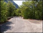
From Bovec, we drive towards the border crossing Predel, but only to the spot where the road branches off to the left into the Možnica valley (the turn-off from the main road is located immediately after the bridge over the river Koritnica, approximately 4 km after the fortress Kluže and only a little before we reach the village Log pod Mangartom). We park at the beginning of the road into the Možnica valley; further driving is prohibited.
Route description:
From the parking lot, we continue on a macadam road which first crosses a torrent stream and then ascends over avalanche slopes. Higher up, the road enters the forest, and we follow it for a good half hour to the spot where it makes a sharp right turn. Right in the middle of the turn, we leave the road which leads towards the recreational home in Možnica and continue straight on a slightly worse road in the direction of Jerebica. Only a little further ahead, the road ends, and we continue the ascent on a gently sloping mountain path. We follow this gently sloping path for approximately 20 minutes, then continue sharply right (straight unmarked path towards the head of Možnica). The path ahead steeply ascends, aided by some fixed safety gear which helps us overcome the steep rocky section. The path then flattens a little and gradually transitions to overgrown slopes, on which we then ascend (in the morning dew we will get fairly wet). The increasingly panoramic path brings us after a good 3 hours of walking to the Jezersko sedlo saddle (Ital. Sell del Lago), where we cross to the Italian side of the mountain.
Here we continue right on the still overgrown path, which higher slightly descends and then gently ascends. Further on, we cross steep grassy slopes which are mainly dangerous for slipping when wet, and behind them in a further 20 minutes we ascend to the summit of Jerebica.

Along the route: Jezersko sedlo (1720m)
Photos:
 1
1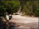 2
2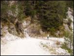 3
3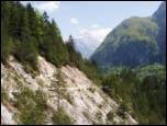 4
4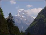 5
5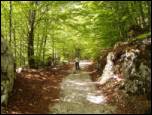 6
6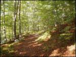 7
7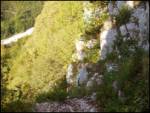 8
8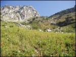 9
9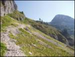 10
10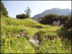 11
11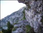 12
12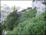 13
13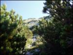 14
14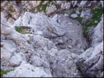 15
15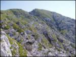 16
16 17
17
Discussion about the trip Možnica - Jerebica
|
| efes26. 08. 2009 |
This year I was up here, living hell because the Italians don't know how to fix the path
|
|
|
|
| lesnik21. 07. 2010 |
Wonderful path, especially the trail from Jezersko sedlo onwards - pure poetry. The via ferrata cable is somewhat damaged in the first part of the path (torn in one place), but the path is still safe enough.
|
|
|
|
| damijanp22. 08. 2010 |
We headed to Jerebica from the Italian side (small parking lot at the outlet of the Canale della Trincea stream) along path no. 653. On the way to Jezersko saddle there is some fallen wood and tall grass on the path (soon you're wet up to your waist). I would warn about one spot closer to the beginning, where fallen trees obscure the markings. When you enter the forest from the scree (by the way: in the morning we had to cross the stream, which was gone in the afternoon  ), turn right as marked. After about ten minutes, on the left side there is a small rock with a sign directing path 653 left uphill (the other path goes straight). After a few meters, you need to turn left again, but there is a lot of fallen wood there and we missed the marks. Instead, we went up a trodden path and after half an hour of searching higher up rejoined the path. So better before the rock with the 653 sign, turn left uphill into the forest and after a few minutes you'll be on the right path (also marked with a cairn, which we discovered on the way back ), turn right as marked. After about ten minutes, on the left side there is a small rock with a sign directing path 653 left uphill (the other path goes straight). After a few meters, you need to turn left again, but there is a lot of fallen wood there and we missed the marks. Instead, we went up a trodden path and after half an hour of searching higher up rejoined the path. So better before the rock with the 653 sign, turn left uphill into the forest and after a few minutes you'll be on the right path (also marked with a cairn, which we discovered on the way back  ). ).
Otherwise, that day on this beautiful mountain we met only two hikers ...
Pictures at the following link: Jerebica
|
|
|
|
| panoramik26. 08. 2011 |
I was on Jerebica on Sunday. The path drags on for almost 5 hours. Otherwise very varied, but it's best to start the path early in the morning because the heat kills you just when you have to cross the scree (around 1.5 hours). Mandatory to have enough water!!! I ran out at the top and it was quite a crisis. Views are beautiful far around. I think it's better to start or even end the tour on the Italian side (shade). On the path some raspberries for a treat, some snake, and from the saddle to the top slippery stones in places.
|
|
|
|
| lepenatka10. 08. 2012 |
Hi, does anyone perhaps know if Poćitniški dom v Možnici is operating and if there's a phone number.
I'm heading that way, looking for accommodation.
|
|
|
|
| ljubitelj gora20. 11. 2012 |
On Saturday I set off for Jerebica. At the starting point in Možnica it said 5 hours, on the Italian side at Rabeljsko jezero 4 hours. I start at Rabeljsko jezero. The path is technically not demanding, runs zigzag, no problems with cliffs to the saddle, further on see pictures from 12 onwards. I recommend the ascent to Jerebica as the path is very nice, from the top wonderful views that take your breath away.
http://www.youtube.com/watch?v=5BqGpjedWyA&feature=youtu.be
|
|
|
|
| limona1. 09. 2013 |
On Thursday, 29.8., we climbed to Jerebica. We decided on the shorter variant from the Italian side. We lost about 15 minutes because we didn't notice the signs for Cima del Lago in time, which are only on the left side of the road if coming from the direction of Predel. The exit from the road to the gravel parking lot is at a pronounced left bend, a few minutes drive from the end of the lake. The further path to Jerebica is excellently marked (path 653) all the way to the saddle, where it joins ours. Up to here no exposure, from the saddle to the top you need to be extra careful on some spots. Wonderful views all the time. I was surprised that this beautiful mountain is so solitary. We didn't meet a single soul the whole way up and down. The last entry at the top was 5 days before ours. We descended the same way. From the saddle downwards there's quite a stretch of slippery rocks and damp vegetation (shady side) all the way to the forest, where you step onto a soft path. We're quite average hikers, yet with all stops for drinking and snacks we took 3.5 hours to the top. Good luck!
|
|
|
|
| nisa18. 09. 2013 |
Please provide a more detailed description of access to the start of the path to Jerebica from the Italian side. I hope snow won't surprise me next week.
Thank you and best regards!
|
|
|
|
| dprapr18. 09. 2013 |
The predecessor has already described it well!
Before the bridge there is a small parking area with signs that you can't miss. From the parking lot you go along the gravel road across wide screes to the forest on the other side below the slopes of Jerebica. There the path turns further right through the forest and then left uphill. If you want a shortcut, go straight uphill along the steep forest gully and above you reach the path markers again. But if you're on this path for the first time, this variant is in my opinion more recommended for descent.
|
|
|
|
| Janiel7419. 06. 2014 |
Does anyone have info on the trail's condition? How many snow patches remain? thanks
|
|
|
|
| IgorZlodej19. 06. 2014 |
Why is snow a problem, since there were no issues getting up there even in winter.
|
|
|
|
| Janiel7420. 06. 2014 |
I don't know if this is an answer to my question....
|
|
|
|
| IgorZlodej20. 06. 2014 |
Do you think someone will go count the snowfields for you? Take appropriate gear and go. That's how it is, even chamois don't bring me information, you have to go look, otherwise it's generally known that there's still a lot of snow in the mountains this year and snowfields can be expected well into summer. That's why such questions are more or less ridiculous.
|
|
|
|
| Janiel7420. 06. 2014 |
If you think you're witty, you've made a serious mistake. The forum is for asking questions.. You can show off at home! I'm ending the debate. And thanks for the kindness.
|
|
|
|
| IgorZlodej20. 06. 2014 |
Before yesterday's slip of three on Mojstrovka, yesterday a hiker's slip under Prehodavci, injured taken to Jesenice hospital. If you don't have gear, wait another month until the snowfields melt. It's not about who is wittier, but the simple fact that there is still snow in the mountains, and for that you need appropriate equipment.
|
|
|
|
| viharnik21. 06. 2014 |
Janiel, if by chance you survive a slip without proper gear and become crippled, that "wittiness" would be your redeeming golden advice.
|
|
|
|
| CarpeDiem24718. 07. 2014 |
Based on yesterday's hike to Jerebica (from the ITA side and start where the road crosses Bele vode), I can say that 3 or 4 snowfields need to be crossed, one of which is relatively demanding to cross. This snowfield is right in the part where you have already been ascending for about half an hour from Jezerskega sedla and then a descent follows, losing at least 50 elevation meters. Carefully! 
|
|
|
|
| Grenaleva25. 07. 2016 |
Has anyone hiked from Možnica recently? How are the pegs and how long is the cable section, as the pictures attached to the route description don't show that worse part.
And it really says 5 hours below, how long is the route for average pace?
Thanks
|
|
|
|
| B225. 07. 2016 |
Whoever starts to Jerebica from Možnica follows the route description along the road. Where the marked path to Jerebica branches off from the unmarked path to the Možnica cirque, one must be careful because this spot is very poorly marked (faint mark and inscription on a stone on the ground), the unmarked path leading straight to the cirque is very trodden and can easily mislead us to follow it.
There are no pegs on the entire route, but right at the first steep sections there are two cables that help with the ascent. This section could be managed without this protection, just requiring a bit more care especially when wet. No other safety gear on the route. The tour is long and strenuous. Walking time of five hours is quite realistic - rather more than less...
|
|
|
|
| IgorZlodej25. 07. 2016 |
The cable on the traverse has been torn for years, so carefully when crossing, as there is some debris and leaves on the ledge. The handhold pegs are OK, on the southern slopes of Snežni vrh just before Jezersko saddle there was a rockfall that partially buried the path for about 20 m, loose rocks have eroded the path in a few places in the area when coming out of the forest.
If the question was posted under Forum-conditions I would attach a photo 
|
|
|
|
| B225. 07. 2016 |
Thanks Igor, you provided fresher and more useful information. I was on Jerebica about three years ago myself...
|
|
|
|
| Grenaleva26. 07. 2016 |
Great thanks, I was looking for Jerebica on the forum but couldn't find it. Shall we open a new thread? Because we plan to go up in the next few days, but still deciding from which direction, as we're sleeping 1 km away from the starting point in Možnica
|
|
|
|
| Grenaleva26. 07. 2016 |
Oh great, I've been there twice and missed it. Igor Zlodej, then please post it on the link above, thanks
|
|
|
|
| IDAS9. 08. 2017 |
8.8.2017 on Jerebica extremely nice and panoramic. From Možnica the path is well marked. The fixed cables, which are only on the lower part of the wall, hold well. But it has one small drawback, no stamp at the top.
|
|
|
|
| darinka427. 07. 2018 |
Twice on this mountain from Možnica. In autumn and summer. You meet few hikers on the way. From our side it's longer and you feel it, because you start from 600 m. From the Italian side 1000 m.
|
|
|
|
| darinka427. 07. 2018 |
Walking time from the parking lot is 5 hours not four. 4 hours is written on the next sign when you're already in the forest. The fast ones probably need less than five hours. Still, there are quite a few elevation gains.
|
|
|
|
| Tadej27. 07. 2018 |
Thanks for the warning. I've corrected it.
|
|
|
|
| Brdar6119. 06. 2019 |
Information for Jerebica visitors. 18.6. we only reached the gully where the path dips a bit-just before the saddle-where the final ascent to the summit begins. There is still a lot of snow in the gully-crossing without proper equipment is not sensible in my opinion-or can be very dangerous.
|
|
|
|
| darinka426. 06. 2019 |
Nice day yesterday, just maybe too muggy on the path. Mostly they hike from the Italian side. From ours from Možnica only four of us. Long path, steepness doesn't relent, but beautiful.
|
|
|
|
| Grenaleva11. 08. 2020 |
The path is excellently secured. Perhaps a sign is missing at the start from the starting point. Follow the path, the first sign is after less than an hour. A large fat viper crossed my path on the grassy slope, so caution is not superfluous. Perhaps the most annoying part is over the scree, but on the grassy slope there is forest fruit available. No crowds on the path, heat can quickly press in the lower part.
|
|
|
|
| darinka410. 07. 2021 22:45:59 |
Today we went with the dog up our side to Jerebica. The snow hasn't spared here either, and there's a lot of fallen trees in the forest. Probably the hunters have cleared the path and sawed the trees. The path is traceable. Only four of us came from Možnica. All the others from Rablja.
|
|
|
|
| planika7725. 05. 2022 12:10:20 |
Have the damaged protections been repaired yet or has anyone hiked recently? Is the path fully safe or very exposed somewhere without protections or with damaged ones? Thanks and best regards!
|
|
|
|
| padez25. 05. 2022 14:12:54 |
What protections? Those couple of meters of wire rope right below, even if they weren't there, as the path runs on a fairly wide ledge. It's not particularly exposed and you can grip the wall.
|
|
|
|
| darinka41. 07. 2022 21:06:23 |
On the first of July, Maks and I headed from Možnica to Jerebica. A really nice day. With views. The wind nicely cooled us on the path. Another eight female and male hikers came from Rabolj. All Slovenians. We were the only ones from Možnica.
|
|
|
|
| simon161. 11. 2022 17:10:53 |
Yesterday up this path. The fixed ropes are in good condition. On the path to the saddle I didn't meet anyone, neither going up nor down. Other hikers came from the Italian side.
|
|
|
|
| Ojstrica3327. 06. 2023 13:57:01 |
Beautiful, solitary path where we didn't meet anyone until Jezersko sedlo. At this time it's a paradise for lovers of alpine flowers.
|
|
|
|
| VanSims9. 10. 2023 14:33:22 |
The trail is scandalously marked. If the responsible PD can't be bothered to clean and maintain the trail, they could at least paint five or six marks at those few key spots. That's exactly where they're needed to follow the trail reasonably.
The trail actually goes from the first spot, where (judging by the footprints almost everyone there for the first time goes astray) into the grass (picture 9 shows the direction of the trail) and not into the forest. Then it goes obviously somewhere to the left (and it doesn't go higher to the right into the forest at another unmarked junction) and under the surrounding walls to the saddle, just before which I caught it after a tough ascent through grass and rocks.
|
|
|
|
| bo_zl25. 08. 2024 18:05:14 |
Today on this trail. My opinion is that the trail is adequately marked, you just need to look carefully for the marks, which are also on the rocks on the ground. It's true that it's a bit harder to follow in the grass, but keep your eyes peeled and it's fine. Helpful as VanSims already wrote: When the trail comes out of the forest, cross the clearing (windthrow, avalanche area) to the right. Then it makes one or two turns through the forest, then turns back into that clearing. Along this clearing the trail runs between bushes and higher grasses, finally leading us to the scree under Mesnovko. On the scree and beyond the trail is excellently visible. Today neither up nor down to the saddle where it joins the trail from Beli vodi I met a living soul. Shame for such a beautiful trail, and it's in Slovenia too. Also on Jerebica there is neither a logbook nor a stamp. Today 5 of us looked for it in vain.
|
|
|
To post a comment you must log in:
If you do not yet have a username, you must first
register.